Locally significant views within London Borough of Bexley - May 2021 - www.bexley.gov.uk
←
→
Page content transcription
If your browser does not render page correctly, please read the page content below
www.bexley.gov.uk

Locally significant views
within London Borough of Bexley

                   May 2021

                                 1
Introduction
Bexley is home to hundreds of spectacular buildings, urban spaces, and natural landscapes, all of which serve as the focal points of views.

Views are not simply points on a map and the spaces between – views are representations of sensory experiences. The identified view is the identification
of the sensory perception of the built or natural environment taken from a particular point or a series of points towards a focal point. Views are about the
interrelationship between the various components, such as the way the foreground and background frames the focal point. Views are complex, allowing
the viewer to focus on individual areas whilst remaining aware of a wider overall context. Views can be static or dynamic. Where views possess
architectural, townscape, landscape, or environmental quality, they refer to one of the most important ways that design is consumed.

Views are worth considering as part of the design process when they possess architectural, townscape, landscape, or environmental quality. This quality
could arise from the interrelationship between the component buildings of a cluster as seen from a certain angle, or the contrast between different
geometries and appearances at the junction of two streets when looked at from a third, and the unexpected glimpse of a river valley which quickly reveals
itself as one moves over the crest of a hill, all contribute to the special character of Bexley.

What is a view? The components
Views are visibility from any given point to another. The view itself is comprised of: the viewpoint; the foreground; the focal point; and the background.
The components of the viewpoint exist only in relation to one another and as part of the ‘view’.

The viewpoint is the location from which the view is taken. Every location in space is a viewpoint, because views exist all around. In the context of
significant views, however, viewpoints are often selected because they offer a vantage not found by other locations. In that sense, viewpoints are often
outputs of the other elements of the view; they represent the location from which the other elements are best seen. A viewpoint could be identified
because it is the spot from which a focal point is most visible, or from which the foreground best synchronises with the background.

The foreground is the area between the viewpoint and the focal point which is visible from the viewpoint.

Although some views are so breath-taking that people stop specially to take it in, the vast majority of all the views are dynamic. Views are usually not taken
in from a viewing platform but rather experienced as one moves through the built space, such as a curving street which continually unfolds as the viewer
walks down it or a skyline in which building forms weave and flow in and out of one another as the viewer rides past on a train.

                                                                                                                                                               2
Locally significant views
Although Bexley contains hundreds of noteworthy buildings and spaces, and each of these in turn could be viewed from any number of viewing points, only
a limited number of the most significant views are designated by local policy as locally significant views.
Locally significant views are those which highlight some of the best aspects of the borough’s built and natural environment offer a solid view of the
landmark and from which the landmark is framed by an appropriate background and foreground/middle ground. These views possess sufficient
architectural, townscape, landscape, or environmental quality.
The London Plan requires development plans to identify locally significant views and to set out what it is about the view that is significant. This document
satisfies this requirement.
This document identifies 9 views which represent the best experience of viewing landmarks within and outside the borough, in terms of the framing of the
landmarks by the foreground, middle ground, and background and the overall composition of the view. These views are designated locally significant views
in the Local Plan and are protected by local policies. These views are then protected from inappropriate development by local planning policy. Development
proposals within views will be resisted where it would have an adverse impact on the aesthetic and character of the view. Where a viewpoint is located
within a proposed development, that development must maintain inclusive public access to the viewing location and enhance the experience of the view.
The views are classified in three ways. There are shorter-range views of the urban townscape (‘Townscape Views) and longer-range views and panoramas
across substantial parts of the borough, focussed on a landmark located outside the borough boundary (‘Regional Views’). Finally, long sweeping views
which take in a variety of landscapes are also identified (‘Landscape and Panoramic Views’). Each type of view has characteristics that contribute to an
appreciation of the borough at the strategic level.
The long-range views are not tightly defined sightlines but rather broad panoramas that take in sweeping visibility over large swathes of land or buildings
from the viewpoint. The focal point is significant but might be highly distant and serves to attract the eye in the general direction thereby encouraging
viewers to take in the broader scene across the panorama. The scene itself is also unlikely to be highly detailed, but rather the foreground, middle ground,
and background is formed by the basic shapes of buildings and the landscape and how those ebb and flow across various topographies. In this sense the
long-range views provide regional context and help to position Bexley within the region. There are two types of long-range views: the Bexley Views refer to
those where the landmark is located within the borough, whilst the Regional Views are those where landmark is located outside of the borough. The
townscape views are shorter-range, appearing more tightly defined and intimate. Instead of the sweeping panoramas of long-range views, the townscape
views follow a relatively narrow viewing corridor such as along a street where buildings on either side create a sense of urban enclosure that steers the
3view. These views include the sort of compositions found in welcoming street scenes or attractive cluster of buildings, and at a range where elements such
as architectural detailing are likely to be visible. Townscape views take in Bexley’s urban landscape, usually some sort of local landmark like a church or a
public house as framed by the local streetscape. Finally, landscape views can be short- or mid-range, where the focus is on the natural landscape or an
important feature within that landscape.
The views are:
Bexley Views
Crossness Pumping Station, Belvedere from Binsey Walk, Abbey Wood
Carrack House/Bosworth House, Erith from Bexley Road, Erith
Hall Place, Bexley from North Park
Spire of St John the Evangelist, Bexley from Bexley High St, Bexley
St Paulinus Church, Crayford from Crayford High Street
Regional Views
Canary Wharf, London from Lesnes Abbey (Viewing Platform), Abbey Wood
Canary Wharf, London from Ruskin Road, Belvedere
Shooters Hill Water Tower, Shooters Hill from The Broadway, Bexleyheath
Landscape and Panoramic Views
Thames River Valley Panorama from Ruskin Road, Belvedere
Crayford Marshes towards Queen Elizabeth II Bridge from London Loop Path, Crayford Ness
This document describes each of these views including the features that contribute to their significance.
Identification of locally significant views: the methodology
The Views were identified through a robust process that established the best view of a series of key landmarks and vistas in terms of visibility of the focal
point, the context presented by the foreground/middle ground and middle ground, and the framing created by the background.
Landmarks were selected to represent locations from across the borough and a variety of types. Landmarks include heritage assets, buildings or landscape
features widely recognised by local people, or buildings or structures of other significance.
4Specialist software Vu.City thoroughly mapped every location from which the landmarks were visible, using a method termed Identifying zones of
theoretical visibility. The mapping relied upon a proprietary accurate 3D model of the area of analysis is required, including building volumes, terrain
topology, and trees. The model used for analysis by VU.CITY has a 15cm accuracy tolerance. Within the 3d model, the landmarks were selected and then
used as emitters to throw “light” (raycasts) over the surrounding scene. When this “light” (raycasts) reaches a viewing plane 1.6m off the ground (the
average human standing viewing plane) it was assumed the target building is visible from that location. The mapping also differentiated the degree of the
landmark visible from any given location, which allowed for the elimination of locations with poor visibility or where key features of the landmark were not
visible.
The ZTV processed produced maps for each landmark. The maps identified the locations from which different elements of the landmarks are assumed
visible. These locations were interrogated with advanced mapping systems and site visits; various combinations of angles and distances created unique
views of the focal point, and the built and natural features that happened to emerge within each of these views was assessed with regard to their own
historical, architectural, or natural significance as well as to their spatial relationship with one another and to the focal point. The particular view which
happened to include the most significant features and presented them in an aesthetically pleasing way in terms of the composition of the view was selected
as the protected view.
Assessing the impact of a development on a view
Locally significant views are protected by London Plan and emerging Local Plan policies.
In determining a planning application related to one of the locally significant views, the primary consideration in the assessment of the impact of a
development proposal on a view is whether the proposal would enhance or harm the features of the view which contribute to its significance or to the
composition of the view as a whole.
The initial test is whether the development is visible within the view. If so, then consideration needs to be given to the impact of the proposal on the focal
point, the foreground and middle ground, and background of the view, and to the composition of the view as a whole.
The proposal enhances the landmark if it would increase the visibility of the landmark. However, where this involves the redevelopment of a site in the
foreground which helps to frame the landmark, the increased visibility must be weighed against the loss to the overall composition of the view. The
replacement building should frame the landmark in a similar or improved way. The proposal enhances the view where it is sensitively designed to positively
respond to the established character of the foreground. Development can also enhance views by opening up new views or increasing the visibility of the
landmark.
5The proposal should be considered to harm the view if it substantially reduces the visibility of the landmark. The proposal harms the view if it blocks views
of significant features within the landmark itself. If for example the landmark is a listed building which derives its significance in part from its chimney, a
proposal which blocks views of that chimney would harm the view. The proposal harms the view if it is within the foreground and appears overly intrusive,
unsightly or prominent. Such an assessment should have regards to the character that makes up the foreground, particularly with regards to the overall
context of the view.
Development proposals in the background of a protected view should give context to the landmarks and not harm the composition of the view as a whole.
The introduction of a new feature into the background does not necessarily cause harm, depending on the existing context.
Detailed guidance on development within locally significant views, including submission requirements, will be set out in the forthcoming Design Guide SPD.
6Townscape views
This section describes the following views:
Crossness Pumping Station, Belvedere from Binsey Walk, Abbey Wood
Carrack House/Bosworth House, Erith from Bexley Road, Erith
Hall Place, Bexley from North Park
St John the Evangelist, Bexley from Bexley High St, Bexley
St Paulinus Church, Crayford from Crayford High Street
7Crossness Pumping Station, Belvedere
Focal Point Viewing Point
Beam Engine House, Crossness Pumping Binsey Walk, Abbey Wood
Station
This view takes in the Grade I listed Beam Engine House – considered one of the most important pieces of industrial heritage within London – rising in the
distance beyond Southmere Lake.
The foreground takes in a sweeping view across Southmere Lake, one of the primary water features in Thamesmead which is set within open parkland and
lined with mature and young trees. The iconic tower blocks of Thamesmead stand along the waterfront to the right, and to the immediate left is a
development site slated for new blocks proposed as part of Peabody’s comprehensive regeneration programme. Straight ahead, the eye is drawn to the
Lakeside Centre arts facility. The foreground offers a microcosm of South Thamesmead: one of the many water features that dominate this former
marshland; the concrete tower blocks that have become synonymous with this part of the borough, and the new residential development that is taking
place across the area.
Poking up behind the Lakeside Centre stands the Beam Engine House. The Grade I listed building is the centrepiece of the Crossness facility, which is a
designated conservation area.
Positive features that contribute to the view’s significance:
The iconic Southmere Lake
The Grade I listed Crossness facility
8Carrack House/Bosworth House, Erith
Focal Point Viewing Point
Upper third of Carrack and Bosworth Houses, Bexley Road from nr Lesney Park Road, Erith
Erith
This view focusses on Carrack House and Bosworth House, two tower blocks that have become landmark buildings within Erith town centre. Both
completed in 1971 as part of the regeneration scheme that saw the largely Victorian town partly replaced with modernist structures, the 14-storey
Bosworth House stands one floor taller than Carrack House.
The foreground consists of Bexley Road as it winds its way on the descent from the residential hinterland into Erith town centre. The steep drop in
topography to the north creates a sense of openness which is unbroken across the River Thames. Two tower blocks stand starkly against the expansive
sky, highlighting their wayfinding role and their significance as iconic buildings within Erith. The background consists of the open sky beyond.
Positive features that contribute to the views significance:
The winding descent of Bexley Road
The cluster of buildings which comprise Erith town centre
The open sky to the north/north-east
9Hall Place, Bexley
Focal Point Viewing Point
Hall Place House The top of the hill at North Park
This view focuses on Hall Place House, which is both Grade I listed and a Scheduled Ancient Monument sat within the Registered Park and Garden. built in
The House was built in two parts – firstly in 1537 for the former Lord Mayor of London Sir John Champneys, and then extended in 1649 by merchant Sir
Robert Austen, lending it a distinct appearance in two styles.
This view takes in the northern elevation of the House as seen from the steep hill that rises to its north. The foreground consists of the open green space
of North Park, originally part of the grounds. The view then follows the Avenue of Trees that once marked the entrance to the House. The background
consists of the lush green landscape of the Cray River Valley.
Positive features that contribute to the view’s significance:
The steep hilltop viewpoint that provides sweeping viewpoints over the river valley
The Avenue of Trees that draw the eye towards the House
The Grade I listed and SAM Hall Place
The background landscape of the Cray River Valley
10St John the Evangelist Church, Bexley
Focal Point Viewing Point
Spire of St John the Evangelist Church Bexley High Street (taken from the northern
pavement outside no. 43 High Street)
The view takes in the mild winding of the historic Bexley High Street before culminating in the striking spire of the Grade II listed St John the Evangelist
Church. The tall and slender spire – made of Bath Stone and standing 47m in height (or 49m with the weathervane) – can be seen from miles around and
has been a prominent feature of the local skyline since 1882.
The foreground consists of the urban enclosure provided by the strong building line that defines Bexley High Street. The view is tightly guided by the
historic buildings that line the high street, until it opens up to make way for a number of mature trees and the church spire.
Positive features that contribute to the view’s significance:
The Bexley Village conservation area
The sense of urban enclosure created by the historic buildings and built form of Bexley High Street
The mature trees within Golden Acre Park, which echo the nearby Green Belt
The Grade II listed church
11St. Paulinus Church, Crayford
Focal Point Viewing Point
Stone tower of St Paulinus Church, Crayford Crayford High Street nr junction with London
Road
The views takes in the curvilinear high street as it gently rises and curves away from the River Cray, culminating in the historic church that sits at the
pinnacle of the hill over the town.
St Paulinus is a Grade II* listed church originating from 1100AD. The tower itself was built in 1406 with angle buttresses, Perpendicular tracery in openings
and embattled parapet.
The foreground consists of the rising Crayford High Street, which here has a compact urban appearance framed on both sides by two-storey parades of
shops from a variety of periods. Although the quality of appearance varies, the built form is pleasing and has a strong sense of rhythm. The street makes a
gentle ascent up the hill and winds slightly to the east and then back to the west, disappearing from view behind a terrace of early Victorian workers
houses.
Positive features that contribute to the view’s significance:
The visual interest created where buildings in the foreground depart from the pattern with slightly different orientations, such as the
mock Tudor-style Dukes Head public house and the locally listed residential terrace
The sense of urban enclosure created by the building line along the High Street
The Grade II* listed church
12Regional views
This section describes the following views:
Canary Wharf, London from Lesnes Abbey (Viewing Platform), Abbey Wood
Canary Wharf, London from Ruskin Road, Belvedere
Shooters Hill Water Tower, Shooters Hill from The Broadway, Bexleyheath
13Canary Wharf Cluster 1
Focal Point Viewing Point
City Bank and HSBC, Canary Wharf Viewing platform within Lesnes Woods
This view takes in the iconic skyscrapers of Canary Wharf from the established viewing platform within Lesnes.
Purposely built from 1987 on the docklands that once hummed with fervent shipping activity, Canary Wharf takes its name from the quay where traders
unloaded cargo of fruit and vegetables imported from the Canaries and other Mediterranean Islands. Although ships no longer unload goods, the area
retains a key role in international trade, now serving as one of the most important financial centres in Europe and the world. As the location of some of the
tallest buildings in the United Kingdom and standing on side of the River Thames, Canary Wharf is visible from across London and beyond, lending it an
almost exclusive wayfinding role at the sub-regional level.
This viewpoint is taken from the viewing platform. The platform includes a bronze plaque highlighting significant buildings within the cluster. Within the
immediate foreground are the ruins of Lesnes Abbey, Grade II listed ruins and a Scheduled Ancient Monument which represents one of the most significant
archaeological and historical sites within the borough. The Lesnes Abbey had been founded in 1178 by Richard de Luci, Chief Justiciar of England, possibly as
penance for his involvement in the assassination of the Archbishop of Canterbury Thomas Beckett. Beyond the ruins emerges Abbey Wood with its fast
growing skyline.
14Canary Wharf is visible in the distance, with the buildings discernible on clearer days. Given the prominence of their height, they are set against a
background of open sky.
Positive features that contribute to the view’s significance:
The cluster of Canary Wharf as viewed from south east London
The GII/SAM ruins of Lesnes Abbey
The modern and growing skyline of Abbey Wood
15Canary Wharf Cluster 2
Focal Point Viewing Point
City Bank and HSBC, Canary Wharf Tyron Way, Sidcup near no. 49
This view of London’s Canary Wharf is significant in part because it is so unexpected: deep within outer London, at the boundary with Kent, a suburban
street offers an uninterrupted view of one of the world’s most important and recognisable business clusters. The cluster emerges in the distance as one
moves around a bend and disappears behind the next. This view of the iconic skyscrapers helps to place Sidcup and the borough within the sub-region, in
terms of its physical location as well as in terms of economic and social relationships.
The foreground consists of a mildly sloping suburban street lined with latter-20th Century semi-detached houses set back from the street by front gardens
and paved drives. It ends where Tyron Way splits into Northcote Drive and Sydney Road. The pair of houses at nos. 115-117 Northcote Drive are
orientated to face back towards the view point, providing a distinct conclusion to the foreground.
The iconic skyscrapers of Canary Wharf stand in the distance behind this pair of houses. Canary Wharf is visible from this location because of the
peculiarity of topographies created by the undulating river valleys formed by the Rivers Cray and the River Thames. This location on Tyron Way sits on
slightly elevated ground before the topography drops off and does not rise again until far out of view. As a result, the sky is interrupted only by the very
tallest of buildings, which are those at Canary Wharf. Given the prominence of their height, they are set against a background of open sky.
Positive features that contribute to the view’s significance:
16 Uninterrupted views of the Canary Wharf skyscrapers
the mild slope along Tyron Way
the building line on both sides of Tyron Way tighten the view
the pair of semi-detached houses at nos. 115-117 Northcote Drive, which provide a neat end to the foreground
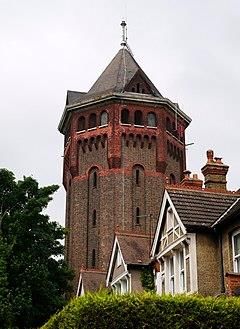
17Shooters Hill Water Tower
Focal Point Viewing Point
Shooters Hill Water Tower The Broadway at the pedestrianised area,
Bexleyheath
This view takes in the Shooters Hill Water Tower along the ancient Watling Street, showcasing its linearity and offering insight into the borough’s history
and geography.
The water tower was built in 1910 in the Gothic revival style and has since become a sub-regional landmark.
The view follows the linear Watling Street from Bexleyheath. Watling Street is an ancient route that has crossed the local area for millennia, used by the
ancient Britons and later paved as one of the main Roman roads in Britannia. The long, linear route, which connects St Albans to the historic Kentish ports
via London, was instrumental in shaping the built environment of both Welling and Bexleyheath, which developed their commercial cores on the route with
residential dwellings being constructed primarily on side streets. Watling Street remains an important route to this day.
The foreground consists of the Broadway, lined by shops and other public buildings, including notably Christchurch. The route continues to comprise the
middle ground, including as it moves up Shooters Hill, marking a transition into inner London, before culminating in the Water Tower.
Positive features that contribute to the view’s significance:
18 The linear historic Watling Street
The Grade II listed Christchurch in the foreground
The rising nature of Shooters Hill
The landmark Water Tower
19Panoramic and Landscape views
This section describes the following views:
Canary Wharf, London from Ruskin Road, Belvedere
Crayford Marshes towards Queen Elizabeth II Bridge from London Loop Path, Crayford Ness
20Thames River Valley panorama
Focal Point Viewing Point
Canary Wharf, south east London, east London Ruskin Road (looking over Clive Road),
Belvedere
This expansive panorama takes in views across the Thames River Valley.
The expansive view is afforded by the elevated viewpoint within Belvedere. Although named after a grand house of that name, the town’s name means
‘beautiful view’ in Italian.
The panorama begins to the northeast with miles of sheds and wind turbines and plant towers that constitutes the industrial heartland of east London.
Moving westward the view takes in swathes of outer London suburbia. The iconic towers of Thamesmead stand to the fore, whilst behind them emerge the
more recent ‘skyscraper apartments’ of modern Stratford. The panorama then takes in the expanse of inner east London with its periodic skyscrapers in
places like Canning Town. The panorama ends with views towards Canary Wharf, which itself seems to peek up from the ancient woodland of Lesnes
Abbey in the near foreground.
21Crayford Marshes landscape
Focal Point Viewing Point
Crayford Marshes towards Queen Elizabeth II London Loop Path within Crayford Ness
Bridge
This panorama takes in the natural landscape and human built features that constitute the Crayford Marshes.
This panorama looks out from the edge of the borough across the Crayford Marshes SSSI. The lush marshland, subdivided by water-filled ditches with
stands of reeds, and occasional hedgerows of native species, stretches to the point where the River Thames meets the River Darent. The overall character
is one of expansive openness, unbroken only by two vital pieces of regional infrastructure: the Dartford Creek Tidal Flood Barrier stands imposing nearby,
whilst the much larger Queen Elizabeth Bridge looks small and thin in the distance.
22You can also read