LOW STRESS BIKE NETWORK PLAN - Bakersfield - 81CYCLE - Kern Council of ...
←
→
Page content transcription
If your browser does not render page correctly, please read the page content below
Bakersfield
LOW STRESS BIKE
NETWORK PLAN
PROPOSAL TO CREATE A LOW-STRESS BIKEWAY
NETWORK IN THE VICINITY OF THE BAKERSFIELD
HIGH-SPEED RAIL STATION

                             ALIFORNIA
                           81CYCLE
                           COALITION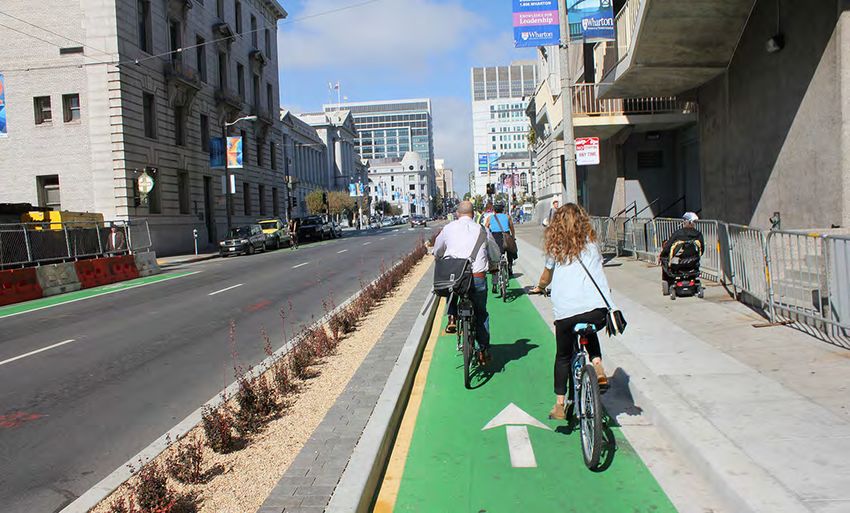
CONTENTS
Executive Summary�������������������������������������������������������������������������������������������������������������� 1
      Summary of Implementation Objectives����������������������������������������������������������������������������������������������� 1
      Recommended Projects���������������������������������������������������������������������������������������������������������������������������� 2
      Methodology���������������������������������������������������������������������������������������������������������������������������������������������� 3
      Existing Conditions ����������������������������������������������������������������������������������������������������������������������������������� 3
      Community Outreach������������������������������������������������������������������������������������������������������������������������������� 3
Introduction�������������������������������������������������������������������������������������������������������������������������� 4
      Site Area ����������������������������������������������������������������������������������������������������������������������������������������������������� 4
      Project Team���������������������������������������������������������������������������������������������������������������������������������������������� 4
      Existing Conditions ���������������������������������������������������������������������������������������������������������������������������������� 4
      Demographics and Mode Share ������������������������������������������������������������������������������������������������������������� 5
      Goals ����������������������������������������������������������������������������������������������������������������������������������������������������������� 6
      Public Health���������������������������������������������������������������������������������������������������������������������������������������������� 7
      Vision: The Low-Stress Network ������������������������������������������������������������������������������������������������������������� 8
      Methodology���������������������������������������������������������������������������������������������������������������������������������������������� 9
      Key Terms��������������������������������������������������������������������������������������������������������������������������������������������������10
      Objectives��������������������������������������������������������������������������������������������������������������������������������������������������11
Best Practices and Design Guidelines����������������������������������������������������������������������������12
      Policy Recommendations�����������������������������������������������������������������������������������������������������������������������12
      Design Guidelines �����������������������������������������������������������������������������������������������������������������������������������13
Background and Planning Context���������������������������������������������������������������������������������18
      Adopted Plans and Projects ������������������������������������������������������������������������������������������������������������������18
Existing + Adopted Network Analysis ����������������������������������������������������������������������������23
      Bike Network Analysis of The Existing Low-Stress Network��������������������������������������������������������������24
      Bike Network Analysis of the Adopted Low-stress Network ������������������������������������������������������������26
Community Outreach �������������������������������������������������������������������������������������������������������29
      Survey Analysis�����������������������������������������������������������������������������������������������������������������������������������������30
Recommended Projects ���������������������������������������������������������������������������������������������������36
      Kern Street Bike Boulevard��������������������������������������������������������������������������������������������������������������������40
      30th/Pacific Street Bike Boulevard��������������������������������������������������������������������������������������������������������42
      Gage Street Bike Boulevard��������������������������������������������������������������������������������������������������������������������44
      Potomac Avenue Bike Boulevard ���������������������������������������������������������������������������������������������������������46
      Virginia Street Bike Boulevard���������������������������������������������������������������������������������������������������������������48
      Kentucky Street Bikeway Extension �����������������������������������������������������������������������������������������������������50
      Bank Street/South Brown Bike Boulevard Extension ������������������������������������������������������������������������52
      Pine Street Bike Boulevard Westchester Extension���������������������������������������������������������������������������54
      California Avenue/99 Freeway Alternative Bikeway Connections ���������������������������������������������������56
      Future High-Speed Rail Station Local Bike Connections��������������������������������������������������������������������58
      Kern Island Canal Extension������������������������������������������������������������������������������������������������������������������60
      Acacia Avenue to the Kern River Parkway��������������������������������������������������������������������������������������������61
      Hageman Flyover Bikeway Extension ��������������������������������������������������������������������������������������������������63
      Roberts Lane Bikeway�����������������������������������������������������������������������������������������������������������������������������65
Implementation������������������������������������������������������������������������������������������������������������������66
      General Considerations of Improvements������������������������������������������������������������������������������������������66
Implementation Drivers��������������������������������������������������������������������������������������������������������������������������67
      Quick and Effective Implementation�����������������������������������������������������������������������������������������������������67
      Stakeholders and Relevant Jurisdictions ���������������������������������������������������������������������������������������������67
      Cost Estimates �����������������������������������������������������������������������������������������������������������������������������������������68
      Potential Funding Sources���������������������������������������������������������������������������������������������������������������������68
      Potential Local Funding Sources�����������������������������������������������������������������������������������������������������������72
Sources���������������������������������������������������������������������������������������������������������������������������������73
Appendix������������������������������������������������������������������������������������������������������������������������������74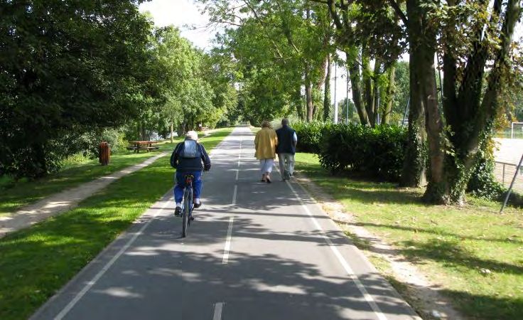
This page intentionally left blank

EXECUTIVE SUMMARY

   Executive Summary

   The arrival of high-speed rail provides a            with primary goals of equity, safety, and
   powerful economic development opportunity            sustainability. The proposal highlights best
   for Bakersfield. The neighborhoods within a          practices in accommodating travelers who
   few miles of the future High-Speed Rail (HSR)        use bikes and provides recommendations
   station can benefit from increased business          for implementing an attractive, safe, and
   activity; more jobs, including resilient jobs in     complete low-stress bicycling network in Central
   small businesses; greater investment in public       Bakersfield.
   amenities; and healthier and safer streets. This
   outcome is not guaranteed, however. Measures         This proposal includes recommendations
   that support biking and walking to and from          for the safety improvements that will most
   the station and in the vicinity of the station are   effectively provide a network of routes that
   integral to success in meeting these goals.          most Bakersfield residents would consider safe
                                                        enough to bike on. If implemented fully, the
   Supported by a Sustainable Transportation            recommendations will create transformative
   Planning grant, the project team has developed       opportunities for a wide range of Bakersfield
   recommendations to maximize the use of bikes,        residents, including seniors and children, as well
   walking, and other active or low-impact mobility     as the potential bicyclist who is ‘interested in
   modes to most effectively support the health         biking but concerned’ about safety.
   and economy of Bakersfield and other cities
   in the Central Valley. These recommendations         SUMMARY OF IMPLEMENTATION
   address what is necessary to create safe and
   comfortable, “low-stress” access between the
                                                        OBJECTIVES
   Bakersfield High-Speed Rail station and key          1. Build out Kern Active Transportation Plan
   destinations within three miles from the station.       (ATP) projects deemed low-stress first
                                                        2. Ensure all intersections and crossings are
   The recommendations prioritize resident
                                                           also low-stress when building a bike network
   access to the existing and future transit hubs

                                                               CALBIKE    | Executive Summary        |   1
FruitvalE avE

                                                                                                mt vErnon avE
                                      moHaWK St

                                                                                                caliFornia avE

                                                                                           BrundagE lanE
                                                                           union avE
                                                  oaK St

      High-Speed Rail Station                              Kern River                     0                     1   2 mi
      Adopted Low Stress Routes                            Parks
      Proposed Low Stress Routes

Figure 1. Recommended Bakersfield low-stress Network

3. Build out network quickly using quick-build                     4. Potomac Avenue Bike Boulevard
   strategies and implement best practices as                      5. Virginia Street Bike Boulevard
   funding becomes available
                                                                   6. Kentucky Street Bikeway Extension
4. Build network out in order of positive
   impact on the connectivity of the low-stress                    7. Bank Street Bike Boulevard Extension
   network                                                         8. Pine Street Bike Boulevard Westchester
5. Update Bakersfield General Plan street                             Extension
   design guidelines and standards to meet                         9. California Avenue/Highway 99 Alternative
   low-stress qualifications to National                              Bikeway Connections
   Association of City Transportation Officials                    10. Future High-Speed Rail Station Local Bike
   (NACTO) standards                                                   Connections
                                                                   11. Kern Island Canal Shared Use Path
RECOMMENDED PROJECTS                                                   Extension
1. Kern Street Bike Boulevard                                      12. Acacia Avenue Bike Boulevard
2. 30th/Pacific Street Bike Boulevard                              13. Hageman Flyover Bikeway
3. Gage Street Bike Boulevard                                      14. Roberts Lane Bikeway
                                                                          CALBIKE      | Executive Summary           |     2
METHODOLOGY                                         COMMUNITY OUTREACH
To create this proposal, the project team used      In addition to the GIS analysis, this proposal
a novel and sophisticated methodology to            relied on qualitative analysis of Bakersfield’s
analyze the effect of specific improvements. The    street network, as explained in hundreds of
method, called the Bicycle Network Analysis,        comments and conversations in an extensive
relies on the truism that a connection between      outreach process. Because of the COVID-19
two points is only as strong as the weakest link.   pandemic and shelter-in-place orders, the
                                                    project team pivoted from face-to-face
EXISTING CONDITIONS                                 engagement and moved to primarily digital or
                                                    online methods for outreach and engagement.
A typical bike trip in Bakersfield can involve
three miles of low-stress residential streets       The outreach plan utilized equitable and
combined with a quarter-mile of frightening         innovative strategies to engage residents
riding on narrow roads with fast traffic. While     who live, work, and travel within the project
Bakersfield has many miles of low-stress streets    area, focusing on residents that are typically
and bike paths, these routes primarily exist        underserved and left out of community
along the Kern River, which has a northeast         planning processes. Outreach strategies
to southwest trajectory and does not serve          included coalition-building; paid survey
residents in the southeast of Bakersfield and       administration; online survey administration
the project area. The Kern River Parkway also       with Community Based Organizations (CBOs),
lacks safe connections from existing low-           public agencies, and neighborhood groups;
stress routes, and to destinations people need      and traditional media outreach, including press
to reach, rendering it useful to a few bike         releases about the project. The project team
riders in higher socioeconomic communities          worked to overcome engagement barriers,
for transportation. Outside of the Kern River       including language and culture, disability
Parkway, there are no low-stress facilities that    access, connectivity to the internet or digital
cross the Kern River, itself a barrier.             tools, socioeconomic status, and barriers to
                                                    in-person outreach resulting from the COVID-19
Weak links in a street network are devastating      pandemic.
for safe mobility. The impact of incomplete
networks is most significant for disadvantaged      Residents shared their travel routines,
populations, who are less likely to own cars        perceptions of biking in Bakersfield, and what
due to income, age, or disability. By fixing        they needed to make biking a pleasant, safe,
specific weak links in Bakersfield’s low-stress     and frequent mode of travel. Residents also
network, planners can create connections            dropped pins in their top three barriers to
that are intuitive and safe for everyone. The       biking in the project area on a digital map.
study underlying this report reviews several
potential improvements to specific weak links
in the low-stress network. The analysis used
Geographic Information Systems (GIS) to
determine precisely which destinations will be
newly accessible thanks to each improvement.
The data illustrate the “network effect,” which
shows how fixing an intersection in one part of
town can make a park or a shopping center or
a school in another part of the city vastly more
accessible to people walking, biking, and taking
transit.

                                                           CALBIKE   | Executive Summary        |     3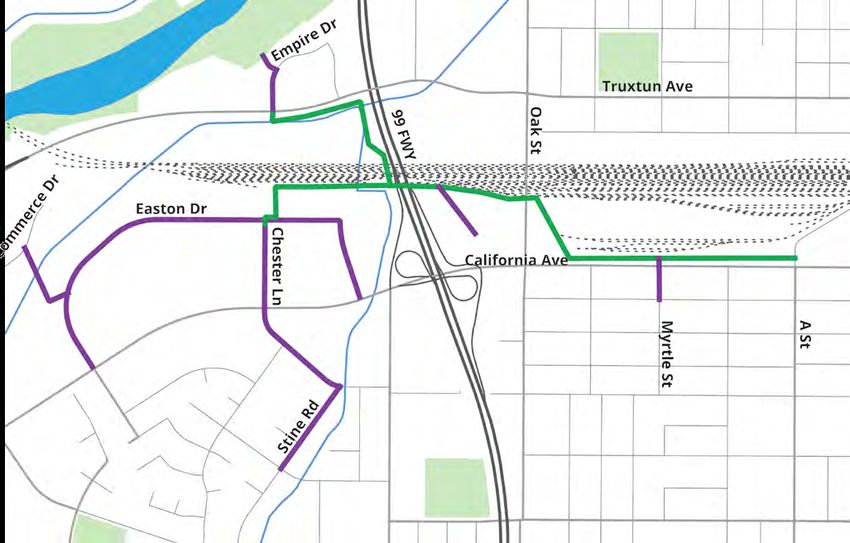
INTRODUCTION

   Introduction

   SITE AREA                                           CalBike planners work directly with Kern COG to
                                                       ensure that the project team delivers a plan that
   The project area is the bicycle travel shed (bike
   shed) around the future High-Speed Rail (HSR)       meets the needs of all stakeholders. CalBike
   station in Bakersfield, California. The project     planners also are part of the GIS analysis,
   team defines the bike shed as a three-mile          development of educational materials and
   radius around the station, or the distance          reports, outreach, and ground-truthing efforts.
   most riders can comfortably ride. The area was
   then adjusted based on the roadway network,         Bike Bakersfield is a Bakersfield-based
   cutting out or extending the three-mile radius to   nonprofit and bike kitchen that serves the
   account for major roads and excluding locations     Kern County area. Bike Bakersfield helped
   like the oil fields to which most riders would      develop the community outreach plan and
   not travel. The project area includes city land,    educational materials and conducted outreach
   unincorporated county neighborhoods, railroad       efforts in the Bakersfield project area. Bike
   property, and canal property.                       Bakersfield worked with CalBike planners to
                                                       develop recommendations and to ground-truth
                                                       suggested routes.
   PROJECT TEAM
   The Project Team in this report refers to the
   organizations described below. Funding for this
                                                       EXISTING CONDITIONS
   project comes from the CalTrans Sustainable         Even though walking rates in Bakersfield
   Transportation Planning Grant.                      are lower than the state average and driving
                                                       rates are above the state average, the city
   California Bicycle Coalition (CalBike) is           has a disproportionate number of collisions
   a statewide nonprofit organization that             resulting in serious injuries or fatalities involving
   advocates equitable, inclusive, and prosperous      pedestrians and cyclists (Bakersfield BPSP,
   communities where bicycling enables all             2020). As reported in the Kern ATP, 60% of
   Californians to lead healthy and joyful lives.      pedestrian or cyclist-involved collisions in
                                                                      CALBIKE    | Introduction        |   4
High-Speed Rail Station
                                                                           0         1         2 mi
     Kern River
     Parks

Figure 2. Site Area and Future High-Speed Rail Station

Bakersfield occurred in the central area around          with 33% of those identifying as “White alone,
the future HSR station between 2009 and 2013.            not Hispanic or Latino,” and 49.5% identifying
                                                         as Hispanic or Latino. Another 7% of residents
The project team analyzed existing conditions            identify as Black, and 7% identify as Asian.
in Bakersfield. During the two years from 2014-          The median income is $62,340, and 18.5% of
2016, according to the Transportation Injury             residents live in poverty. In Bakersfield, 80% of
Mapping System (TIMS), 233 people on a bicycle           people older than 25 have a high school degree
were injured or killed, and 346 pedestrians              or higher and 22% have a bachelor’s degree or
were injured or killed, with a total of 45 people        higher (ACS, 2019).
killed in Bakersfield. During the two years from
2017-2019, according to TIMS, 231 people on a            People living below the poverty line in
bicycle were injured or killed, 436 pedestrians
                                                         Bakersfield were more likely to take public
were injured or killed, and a total of 53 people
                                                         transportation or walk but still mostly drove to
died on Bakersfield streets.
                                                         work. Among people living below the poverty
                                                         line, 3% took public transit, and 3% walked.
DEMOGRAPHICS AND MODE SHARE
68% of Bakersfield residents identify as White,          Current street designs and land uses in
                                                                       CALBIKE   | Introduction       |     5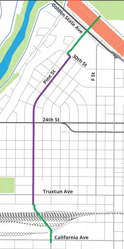
Figure 3. Pedestrian and cyclist-involved collisions in the project area between 2017 and 2019 (Source: TIMS)

Bakersfield prioritize the movement and                            the primary users of the network, to housing,
storage of cars. Conditions on the roadways                        work, recreation, and transit centers. It has
create a hostile environment for cyclists and                      the potential to boost the local economy by
pedestrians. As a result, most trips are by private                attracting tourists. Once implemented, this
automobile rather than active travel modes of                      project will safely connect disadvantaged
transportation. In 2018, 92.6% of people drove                     communities to downtown Bakersfield through a
to work, while only 1% took public transit, 0.8%                   low-stress network.
walked, and 2.1% used other means (ACS, 2018).
                                                                   Safety
GOALS                                                              The recommended projects in this report will
                                                                   promote safety for active transportation users
This project will facilitate a safe, equitable, and                throughout the Bakersfield Metropolitan area.
sustainable low-stress bike network in Central                     Current conditions and data show a serious
Bakersfield. When Bakersfield completes its                        safety issue with cycling and walking, particularly
low-stress bikeway network, as outlined in this                    in the project area. This project aims to enhance
proposal, residents and commuters will be able                     public safety for cyclists and pedestrians and
to access any point in the study area using low-                   reduce the high number of pedestrian and
stress bike routes.                                                bicyclist-involved collisions in Bakersfield.
Equity                                                             Users from ages 8-80 will feel comfortable and
Building a comprehensive low-stress bike                           safe riding anywhere within the project area
network in Bakersfield will promote equity. High-                  once the low-stress streets designs detailed in
quality bike infrastructure lowers accessibility                   this proposal are implemented. These designs
barriers for those who may not otherwise feel                      include protected crossings and intersections
safe biking, including children and seniors.                       and diverting cyclist traffic away from collector
It increases access to many cost-effective,                        streets and vehicular traffic when possible. As
healthy, and environmentally sustainable                           evidenced in cities such as Seville, low-stress
forms of transportation, including cycling and                     bicycle networks improve safety and dramatically
mass transit. It will also connect residents,                      increase bicycle ridership.

                                                                                     CALBIKE      | Introduction   |   6
Sustainability community health, and environmental
Improving the bicycle network and connecting it conditions all at the same time. In other words,
to existing and adopted transit will help build a in a time of tight budgets, limited resources,
sustainable multimodal transportation system. declining workforce numbers, and growing
It will also create more livable neighborhoods health problems creating opportunities for safe
for Bakersfield residents. By increasing active bicycling and walking can literally provide public
transportation trips and reducing automobile health practitioners with one of the biggest
trips, the project will also reduce air pollution bangs for their already-stretched buck.”
caused by single-occupancy traffic while also
alleviating vehicular traffic congestion. A well- Disinvestment in active transportation
designed bicycle network can also create a infrastructure and public reduces neighborhood
sense of place and spur new development, cohesion and negatively impacts health
promoting a denser, more vibrant urban core outcomes and mortality for residents
that is not reliant on surface parking and throughout the region. The Central Valley
vehicular traffic with a smaller carbon footprint. is a region where policymakers are quick to
invest public dollars into roads and freeways
PUBLIC HEALTH to the detriment of the quality of life in the
area. The prioritization of traditional forms
According to the 2015-2017 Community Health
of transportation also works against stated
Assessment (CHA) in Kern County, the county
goals and policies of local, state, and federal
failed to meet Healthy People 2020 targets in
governments, including:
2013 and was ranked the 56th worst county
for heart disease deaths out of 58 counties »» Greenhouse Gas reductions (GHG)
in California. Kern County has a much higher
mortality rate for diabetes and heart disease
»» Vehicle Miles Traveled reductions (VMT)
than the rest of the state. Also, the percentage »» Air quality improvements and mobile-source
of obese residents in Kern is higher than the emissions reductions
state average, and the rate of individuals at a
healthy weight is lower in Kern than the rest of »» Healthy People 2030 Framework
the state.
»» Reducing traffic deaths related to biking and
Thus, having a Central Valley zip code means walking
a resident is more likely to have poor health
outcomes and high mortality than the rest Investments in an active transportation
of the state. Many individual, societal, and network that is safe, usable, multimodal, and
environmental issues contribute to these health well-connected will enable more individuals
issues. Getting more people within a community of diverse abilities and backgrounds to try
using bicycles as a form of transportation different modes of transportation. This
will address several of the root causes of the investment will create a ripple effect in the
problem, including lack of exercise and poor air broader community and the environment. Even
quality. a moderate mode shift to more bike riding will
provide a measurable impact on individual,
Improved public health has provided the impetus societal, and environmental problems.
for transportation changes across California. Increasing biking is a single solution to an array
Quality-of-life concerns can be addressed of issues Central Valley residents face.
through robust investment in low-stress active
transportation infrastructure. A public health The transportation of the region not only
perspective helps understand and measure the impacts the health outcomes for residents but
impact of new infrastructure on residents. their economic wellbeing as well. According to
TRIP Net’s Central Valley Roads Report, “driving
According to the Safe Routes Partnership, on Central Valley roads that are deteriorated,
“Active transportation investments have congested and that lack some desirable safety
“the potential to transform individual health, features costs the average driver $1,765
CALBIKE | Introduction | 7annually in the form of additional vehicle bike lane in one neighborhood, full active
operating costs (VOC) as a result of driving on transportation networks will encourage more
rough roads, the cost of lost time and wasted residents of diverse abilities to begin bicycling.
fuel due to congestion, and the financial cost of Residents also need to be engaged in the
traffic crashes.” planning process. Community-based planning
of low-stress networks will create pathways for
The first step is policy decisions to invest in communicating important information, such
a robust, low-stress active transportation as local air quality conditions and construction
network. Active transportation gives the updates, and greater utilization of the
biggest bang for each public dollar spent infrastructure because residents were a part of
on transportation modernization because it the process.
positively impacts individual health outcomes
and the economic health outcomes of If the ride to a destination (work, parks, grocery
the community while reducing the cost of stores, schools) is too long or not connected
maintenance. Bike facilities require less through low-stress facilities, residents will opt
maintenance than traditional roadways, to drive and miss out on exercise. Therefore, a
bikeway routes along canals, railroads, and connected and convenient network is crucial. It
other existing infrastructure can be considered is essential to design low-stress bike networks
infill development that reduces construction that avoid vehicle traffic when possible and
costs, dust, and emissions. Investments in active make sure that all crossings of busy streets are
transportation infrastructure alongside facilities safe and comfortable. A well-designed bike
other than traditional roadways can also help network will encourage a mode shift to reduce
preserve fragile ecosystems. mobile-emissions pollution sources, including
traffic congestion, idling, and parking lot usage.
Single-occupancy vehicle traffic is the primary This mode shift will improve the air quality of
source of mobile emissions in the Central Central Valley communities.
Valley. The best way to remove single-
occupancy vehicular traffic is to create active To tap into cycling’s full public health potential,
transportation networks that residents want bike networks must be adjacent or connected
to use. Encouraging residents to opt out to destinations like grocery stores, parks, and
of private automobiles for transportation other community resources, without gaps in
requires engineering a system that optimizes the network. These bike networks are among
active transportation while determining the most effective ways to introduce new
and prioritizing residents’ needs. Engaging riders to safe cycling, foster continuing interest,
residents to eliminate single-occupancy and build a sense of ownership for users of
emissions can impact air quality and health community spaces while enhancing access to
outcomes related to pollution. According to essential services and shopping destinations.
Safe Routes to School, “improved air quality—
resulting from an increase in cycling modal VISION: THE LOW-STRESS NETWORK
share—reduced disability-adjusted life years
for cardiopulmonary disease caused by poor Low-stress bicycle networks have proven to be
air quality.” Safe Routes to School also found very useful in cities that have implemented them.
that “the health benefits of shifting from car Seville, Spain, is an example of a successful rapid
to bicycle was associated with greater benefits implementation of a low-stress bicycle network.
from increased physical activity (3-14 months of Rather than building disconnected segments over
life gained) compared with potential effects of time, Seville added 75 miles of low-stress bicycle
inhaled air pollution (0.8-40 days of life lost).” infrastructure in around four years, creating a
well-connected network. The project saw drastic
Regionally-connected active transportation results. Daily bike trips rose from 13,000 to
networks hold the potential for transformative 72,000 in just three years, and cycling became
health benefits for residents anywhere in the twice as safe (Calvo & Marques, 2020). We can
Central Valley. Compared to a disconnected take several key lessons from the Seville example.
CALBIKE | Introduction | 8While many factors determine stress level, METHODOLOGY
significant factors include lane count, road
People for Bikes, a non-profit organization,
width, traffic speeds, and the presence of a
created the Bicycle Network Analysis (BNA)
parking lane. The type of bicycle facility also
as a public data analysis tool to measure
impacts the user’s stress level. In general,
connectivity between places on low-stress
shared use paths, bike boulevards on low-
bicycle networks. The BNA is derived from
speed, low-volume streets, and separated bike
four factors: data collection, traffic stress
lanes tend to be lower stress, while painted bike
analysis, destination access analysis, and score
lanes on high-volume, high-speed roads tend to
aggregation. Each of these factors has a unique
be higher stress.
methodology that, when joined together,
produce numerical scores representing the
levels of stress for connections between places
within a specific boundary.
Data Collection
By utilizing OpenStreetMap and the United
States 2010 Census, the BNA gathers
information on geographic units of analysis
and population and employment data, all of
which provide a baseline of data for the rest
of the analysis. The BNA is meant for public
use. Therefore, it uses publicly available data
to ensure the accessibility of community
stakeholders. These data sources are consistent
Figure 4. Protected bicycle lanes in Seville, Spain. Photo by with their methodology, so the BNA can easily
Adriana CC BY be updated as more data is gathered.
For a network to be low-stress, not only does it Traffic Stress Analysis
need to have low-stress routes, but these routes Most bicycle transportation in cities happens
have to connect so that riders can get from one on or along existing roads. Each road has a set
destination to another without using any high- of characteristics such as the number of lanes,
stress connections. The stress level of a route speed limit, frequency of intersections, and type
is determined by its most stressful component. of bicycle facility (buffered lane, buffered lane
For example, if a route includes mostly local with parking, sharrow, etc.). Using these street
bike boulevards but requires crossing a high- characteristics, BNA evaluates these roads and
stress intersection, the route is classified as determines if cycling is considered a low-stress
high stress. For this reason, it is common to or high-stress experience.
see “islands of low-stress connectivity” that are
disconnected by barriers such as freeways, Destination Access Analysis
railroads, canals, and high-speed arterials that Access to destinations means determining
lack safe crossings. if those living in a particular area can access
opportunities, core services, recreation, retail,
A complete, low-stress network is key to ensuring transit, and other people along a low-stress
access to goods and services across the city. route. A score of 0-100 is calculated based on
Therefore, the network as a whole is prioritized the number of those destinations available.
over individual segments. To determine network
stress levels, the project team evaluated route Score Aggregation
segments and their intersections through the Scores are aggregated on both the individual
Bicycle Network Analysis (BNA) tool. BNA is an census block (and census block equivalent)
open-source tool designed to display bicycle and at the overall city level. For this study, the
stress levels at the road segment, intersection, analysis focuses mostly on census block levels of
census block, and neighborhood levels. connectivity.
CALBIKE | Introduction | 9KEY TERMS
Term Definition
This document refers to projects and infrastructure adopted through the
Kern Active Transportation Plan in 2018 (ATP) that qualify as low-stress within
Adopted the project area, as well as other relevant (funded and unfunded) outside of
the ATP that are also deemed low-stress as “adopted.” Information on these
projects is in the “Background and Planning Context” section.
Bike boulevards follow NACTO design guidance for routes on residential
streets that prioritize the safety of active transportation users, particularly
at crossings and intersections. Bike boulevard designs are often paired
Bike Boulevards with traffic calming and urban greening. Routes with sharrows can be
low-stress if they are implemented in combination with traffic calming
treatments. See Design Guidelines for more on bike boulevard and
protected bike lane design.
A bike lane is a Class II Bikeway that provides a striped, signed, and
stenciled lane for one-way travel on a street or highway. Bike lanes
typically flow in the same direction as traffic, are bordered by a solid white
line (6-8inches wide), and include painted words/symbols at intersections.
Bike Lanes
They require a minimum width of 4 feet of rideable surface with a 5-6 feet
minimum lane with paint. Bike lane design should include intersection
treatments that easily guide turning motorists and cyclists traveling
straight to avoid conflicts.
A bike path is a Class I Bikeway for travel on a paved right-of-way
completely separated from the street where motor vehicles travel. An
Bike Paths example of this is the Kern River Parkway. To fully meet low-stress criteria,
bike paths must connect to other low-stress facilities in the network and
address potential interactions with driveways, motorists, and pedestrians.
Bikeway classifications used in this report are an application of low-stress
Bikeway Classification methodology, best practices guidelines, and the City of Oakland’s Bikeway
Types to the existing classifications from the Kern Bicycle Master Plan.
A buffered bike lane requires at least a 3-foot buffer and minimum 4-foot
Buffered Bike Lane rideable space, the same as a conventional bike lane. Markings include
solid painted lines on the edges of the buffer and bike lane.
A quality of a low-stress path or road is its connectivity to other low-
Connectivity stress routes. This plan uses the BNA Score to quantify connectivity. See
definition for low-stress.
Cycle tracks have physical barriers (bollards, medians, raised curbs, etc.)
Cycle Tracks and vibrant paint to prevent encroachment by motorized traffic. They can
allow for one- or two-way cycling traffic.
Destinations are high-value locations of services that residents regularly use,
Destination
including parks, medical centers, grocery stores, job centers, and schools.
Infrastructure currently in place that is deemed low-stress by the Bike
Network Analysis tool is called “existing” in this plan. Not all current
Existing
infrastructure in the project area met the criteria for low-stress. (insert
map of all existing, with currently low-stress)
The mixing zone or junction of two or more paths that serve any form of
Intersection transportation is an intersection. See Design Guidelines for more on low-
stress intersection design.
CALBIKE | Introduction | 10A bike route that provides connections between destinations efficiently
and comfortably is classified as low-stress. The Mineta Transportation
Institute (MTI) and People for Bikes define low-stress bikeways as
Low-Stress
“providing routes between people’s origins and destinations that do not
require cyclists to use links that exceed their tolerance for traffic stress,
and that do not involve an undue level of detour.”
Unsignalized, unprotected, or unofficial intersections between the active
Minor Crossing transportation network and motor vehicle traffic are minor crossings.
Minor crossings include unmarked crosswalks and intersections.
Quick-build is a method for building bike and pedestrian safety projects
quickly and inexpensively. Quick-build projects use low-cost materials
such as paint and plastic bollards. These projects yield immediate results,
Quick-Build increase public support, and safeguard against political changes that could
sideline long-term plans. CalBike’s Quick-Build Guide lists low-cost, high
impact treatments to improve the connectivity of low-stress routes quickly
and flexibly.
The recommended projects are those that the project team has
determined are critical to complete the low-stress network in the
Recommended Bakersfield project area. These recommended projects include both
adopted projects and projects that expand on the adopted projects’ low-
stress designs.
Facilities that give pedestrians and cyclists the exclusive right of way and
are physically protected from motor vehicle traffic are shared use paths.
Shared Use Path FWHA’s design guidance on shared use paths is used for the existing,
adopted, and recommended routes in this report. See Design Guidelines
for more on shared use path design.
A targeted improvement to an intersection or crossing that will create
Spot Improvement or enhance a pedestrian and cyclist facility in a single location is a spot
improvement.
Traffic calming includes an array of methods to slow the speed of cars,
and it is required to create a genuinely low-stress bike boulevard. Speed
Traffic Calming and traffic volume management using mini traffic circles, greening, speed
bumps, traffic diversion, curb extensions, innovative parking placement
are all traffic calming measures.
OBJECTIVES 1. Build out Kern ATP Network Projects
deemed low-stress first
The project team analyzed current
transportation plans applicable to the study 2. Ensure all intersections and crossings are
area and found overlapping objectives, and also low-stress when building a bike network
adopted projects that already include the 3. Build out network quickly using quick-build
development of a complete low-stress network strategies and implement best practices as
(see Background and Planning Context). This funding becomes available
project’s vision and goals are to highlight the
4. Build network out in order of positive
existing and adopted low-stress network, thus
impact on the connectivity of the low-stress
expanding on local agencies’ work and further
network
improving biking and walking conditions.
5. Update Bakersfield General Plan street
design guidelines and standards to
meet low-stress qualifications to NACTO
standards
CALBIKE | Introduction | 11BEST PRACTICES AND DESIGN GUIDELINES
Best Practices and Design Guidelines
Low-stress guidance in this report is from the projects to inform future projects.
National Association of City Transportation Implement Quick Build Strategies
Officials’ (NACTO) Urban Street Design Guide, Quick-builds of the entire network yield
Urban Bikeway Design Guide, and Don’t Give immediate results, build public support, and
Up At the Intersection. See the Implementation safeguard against political regime changes
section for more information on design that could stall plans. CalBike’s Quick-Build
guidance and standards. The Federal Highway Guide 2020 recommends low-cost, high impact
Administration’s (FHWA) Guidance on Traffic treatments to increase bike connectivity quickly
Calming discusses the benefits and strategies and flexibly.
for implementing traffic calming measures for
low-stress facilities in neighborhoods. Create Multi-Disciplinary Teams
Ensure that designers work with operations,
POLICY RECOMMENDATIONS as operations staff will be the ones who
will maintain the system. Involve multiple
Cities that have implemented successful parties in the planning and implementation
low-stress networks have used the following process, including designers, operations staff,
strategies when planning the network: community stakeholders, and elected officials.
However, the City of Bakersfield should be the
Involve the Public primary actor.
Obtain public support for the project before
building a complete bicycle network. Make Connect Key Destinations
sure to engage traditionally marginalized and Start the network at the densest core and
underrepresented groups to get input on which already has the most existing bicycle
community needs. Continue to fully engage, not infrastructure. Then connect it outward, taking
merely reach out to the community throughout care to include neighborhoods where the most
the process, raise awareness for the project, disenfranchised communities live.
and gather ongoing feedback on completed
CALBIKE | Best Practices and Design Guidelines | 12DESIGN GUIDELINES
This report recommends three types of low-
stress bikeways: bicycle boulevards, protected
bike lanes, and shared use paths, as well as
the adoption of low-stress intersections for
all of these types. As these facility types may
vary in quality, this report recommends that
the City follow the best practices outlined by
the National Association of City Transportation
Officials (NACTO) Urban Bikeway Design Guide.
The Urban Bikeway Design Guide provides
Federal Highway Authority (FHWA) approved
design standards and was endorsed by Caltrans
in the 2014 memorandum “Design Flexibility in
Multimodal Design.” Figure 5. Intersection Treatments on a Bicycle Boulevard
Bicycle Boulevards Traffic calming measures are essential for
Bicycle boulevards have low automobile bicycle boulevards to help manage speed and
traffic volume and speeds, and they should volume. Posted speed limits should be 25 mph
be designed to prioritize bicycles over cars. or below and should be combined with targeted
Wayfinding measures such as pavement enforcement and vertical and horizontal
markings and route signage, traffic calming deflection. Vertical deflections are wide, slight
measures, crossing treatments, and green pavement elevations, such as 3- to 4-inch speed
infrastructure are all methods to prioritize bike humps, speed cushions, or raised crosswalks.
traffic. Wayfinding alone is not sufficient to Horizontal deflections narrow the roadway and
create a low-stress bike boulevard, however. include curb extensions or bulb-outs, chicanes,
It must be used in conjunction with the other median islands, and traffic circles.
measures mentioned.
As collisions are most frequent at intersections,
Street signs and pavement markings are it is vital to create protected intersections where
essential to create safe bicycle boulevards, bicycle boulevards cross high-traffic roads.
as they encourage cyclists to use designated For minor intersections between low traffic
routes and let motorists know that they should streets, the use of stop signs should be limited
drive slowly. Street signs are most effective on the bike boulevard and reoriented to the
when they have consistent, recognizable cross streets. Stop signs inhibit cyclists from
branding that provides a visual identity to the efficiently traveling because they are inefficient
bike boulevard. They should be placed roughly for a cyclist to conserve energy and often create
every 2-3 blocks throughout the route and at delays for cyclists to enter the intersection.
intersections to indicate how to remain on Limiting the use of stop signs may attract
the route. Signs placed near route turns or more motorists, so this measure must be used
junctions with other routes are decision signs, in conjunction with traffic calming measures.
and they should include directional arrows, There should be traffic control elements at
route or destination names, and distances. They every intersection, such as stop signs on cross
may also include time estimates to destinations. streets, traffic circles, and pavement markings
Signs should be used in conjunction with in the intersection.
regular pavement markings to let cyclists know
where to position themselves and remind When bicycle boulevards intersect with major
motorists that they share the road with cyclists. streets, city planners need to take additional
NACTO recommends that pavement markings measures to make motorists aware of cyclists
be at least 112 inches by 40 inches to ensure and shorten crossing distances for cyclists.
that they are visible to all road users. Advanced warning signs, intersection crossing
CALBIKE | Best Practices and Design Guidelines | 13markings, raised intersections, and warning cars from parking in the bike lane, and improve
beacons increase the visibility of cyclists. Curb user perceptions of comfort and safety.
extensions, bicycle forward stop bars, refuge
islands, and bike boxes decrease crossing Protected bicycle lanes are appropriate for
distances. At signalized intersections, separate routes that would otherwise be high stress,
bicycle signal heads can give cyclists a head including streets with high traffic volumes and
start. The specific treatments used will vary speeds as well as frequent double parking.
based on the conditions of the intersection. The lane should be at least 5-7’ wide and
clearly marked with street signs and pavement
Finally, green infrastructure helps enhance bike markings. If the barrier is a parking lane, there
boulevards. Green infrastructure elements, should be at least a 3’ buffer between the
such as street trees, bioswales, and rain parking and bike lanes to prevent collisions with
gardens, not only manage stormwater and doors, and the combined width of the bike lane
create a more pleasant environment, but they and buffer should be at least 11’. There should
can also be used in conjunction with traffic also not be parking within 30’ of intersections,
calming measures. They can be placed in and other barriers, such as concrete islands,
medians, curb extensions, and traffic circles. should be placed there instead.
Protected Bike Lanes Shared Use Paths
Protected bike lanes are one-way bicycle Shared use paths provide low-stress bicycle
paths at street level separated from traffic infrastructure suitable for children. They are
by a physical barrier, such as a parking lane, fully separated from motorized vehicles and are
raised concrete curbs, bollards, or planters. The used by both pedestrians and non-motorized
project team does not define bike lanes with vehicles such as bicycles, wheelchairs, scooters,
painted buffers to be protected, as motorists and skateboards. They can be built within a
can easily cross the buffer. Protected bike lanes highway’s right-of-way or inside an independent
reduce the risk of collisions with cars, prevent right-of-way.
Figure 6. Protected bike lane in San Francisco
CALBIKE | Best Practices and Design Guidelines | 14Bidirectional paths should be at least 10’ and at facility remains low-stress for all users. Advanced
least 12-14’ in high volume areas. Center stripe warning signs and pavement markings should
lines can help organize traffic and improve alert both path and roadway users of upcoming
safety. To ensure accessibility, shared use paths intersections, and traffic calming measures
should have a firm, slip-resistant surface and a should be implemented on the roadways to
grade less than 5%. reduce automobile speeds. Crossing distances for
path users should be kept as short as possible,
If shared use paths intersect with roadways, and where possible, high-visibility crosswalks with
extra measures must be taken to ensure that the separate bike signals should be used.
Figure 7. Shared use path
Low-stress Intersections with right-turning vehicles, and reduce signal
As intersections tend to be high conflict delay. Bike boxes should be 10-16 feet deep,
zones, intersection treatments are paramount clearly marked with pavement markings and
to creating low-stress bicycle networks. colored paint, and have a clear stop line for cars.
Treatments should increase visibility
and delineate a clear right of way. While Intersection crossing markings are pavement
appropriate treatments will vary depending markings that indicate that a bike lane is
on the specific conditions of the intersection, continued through an intersection. They are
NACTO recommends the following: bike boxes, typically dotted lines that help cyclists know
intersection crossing markings, two-stage turn where to ride, alert motorists to cyclists, and
queue boxes, median refuge islands, through remind right-turners that cyclists have priority.
bike lanes, and combined bike lane/ turn lane. Additional pavement markings, such as bike
arrows or paint, increase the visibility of
Bike boxes are designated bike areas at intersection crossing markings.
intersections in front of the traffic lane. They
are appropriate at signalized intersections and Two-stage turn queue boxes are similar to
increase the visibility of cyclists, reduce conflict bike boxes, but they are placed in areas where
CALBIKE | Best Practices and Design Guidelines | 15cyclists frequently turn across an intersection, bike lane delineation is dashed in the area where
either left from a right-side bike lane or right motorists can merge into the lane. Through lanes
from a left-side bike lane. and bike pockets give both cyclists and motorists
a clear travel path. This alerts motorists that
Median refuge islands shorten the distance that bikes may be passing them as they merge and
cyclists need to cross, calm traffic by narrowing allows all users to avoid conflict. To further
the roadway width for motorists and provide a highlight the conflict zone and increase visibility,
space for cyclists to wait for gaps in traffic. They the bicycle pocket may be painted. Combined
are often used at unsignalized intersections but bike and turn lanes, or mixing zones, are similar,
can be supplemented with bicycle signals, hybrid but instead of having a dedicated lane, the turn
beacons, or active warning beacons. lane and bike lane are combined. However, there
are pavement markings that indicate where the
Through bicycle lanes or bicycle pockets position cyclist should position themself. This increases
bicyclists at intersections with turn only lanes. motorist awareness of cyclists and encourages
They are used on streets with bike lanes, and the them to give cyclists priority.
Figure 8. Low stress protected intersection
CALBIKE | Best Practices and Design Guidelines | 16Branding, Naming, & Wayfinding pavement markings that direct cyclists to and
The low-stress bike route should follow through routes. There are three main types of
consistent design standards. Having consistent bike route signage: confirmation signs, turn
branding not only contributes to a sense of signs, and decision signs. Confirmation signs let
place but also improves safety by making the cyclists and motorists know that they are on a
bicycle network more recognizable and easy to designated bike route. They should be placed
follow for both cyclists and motorists.
every 2-3 blocks. Turn signs should be set
shortly before turns. Pavement markings are
While there are wayfinding conventions as well
as required standards defined by the MUTCD, used effectively in conjunction with or instead
there is some room for creativity. Performing of confirmation and turn signs. Finally, decision
public outreach to determine branding and signs are placed at the junctions of two or more
naming can be an effective way to engage the bikeways and should include the direction and
public and raise awareness for the network. mileage of each route. (NACTO Urban Bikeway
Route wayfinding includes signage and Design Guide, 2012).
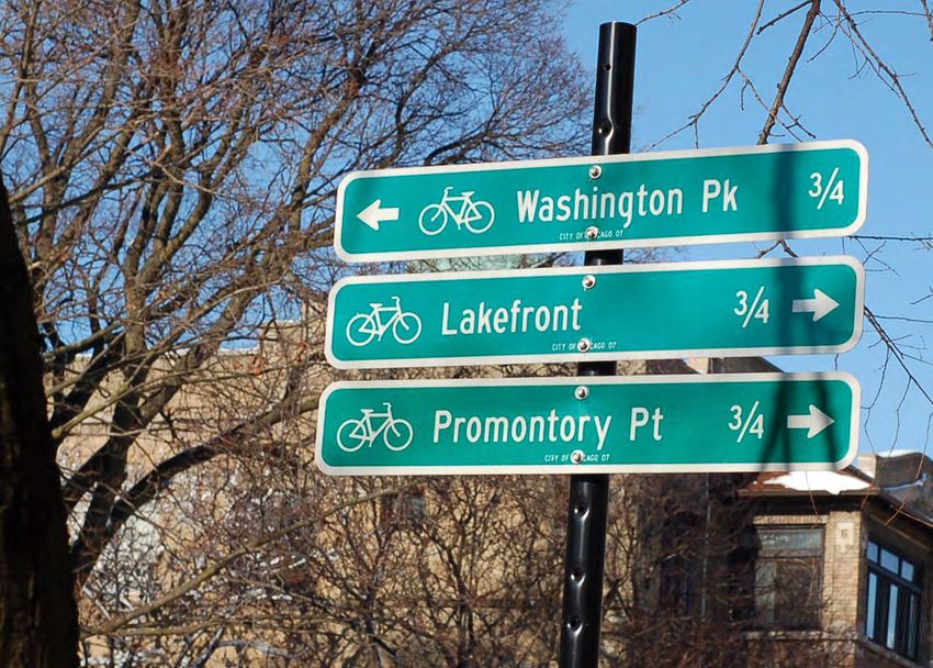
Figure 9. Directional bike sign in Chicago. Photo by Ruth Hansen CC-BY
CALBIKE | Best Practices and Design Guidelines | 17BACKGROUND AND PLANNING
CONTEXT
Background and Planning Context
ADOPTED PLANS AND PROJECTS Kern County Active Transportation Plan (2018)
The Kern County Active Transportation Plan
In the past few years, there have been several
(Kern ATP) was drafted by Alta Planning +
new plans that address transportation planning
Design for the Kern Council of Governments
in Bakersfield and Kern County as a whole.
(Kern COG). It includes plans for over 1,200
Among these are the Kern County Active
miles of updated and new bikeway projects,
Transportation Plan (2018), the Downtown
300 miles of pedestrian network improvements,
Bakersfield High-Speed Rail Station Area
potential locations of new end-of-trip facilities,
Plan (2018), and the Bakersfield Bicycle and
and spot improvements. The funding for these
Pedestrian Safety Plan (2020). These plans
projects comes from California’s Cap-and-Trade
share common objectives, including:
Program and Caltrans’s Active Transportation
1. Create a sustainable multimodal Program. Program funding allocates a minimum
transportation system that is reliable of 25% for sidewalk and bicycle network
and safe improvements in disadvantaged communities.
2. Increase connectivity to jobs,
transportation, and activity centers The Kern Active Transportation Plan (Kern ATP)
by expanding bicycle and pedestrian identifies improvements at the regional and
networks county levels, and this report focuses on both
the pedestrian (0.5-mile radius) and bicycle
3. Serve disadvantaged communities by
(3-miles radius) travel sheds of existing and
increasing mobility and transportation
adopted transit hubs. This report’s study area
access with resident needs in mind
includes pedestrian projects within a 0.5-mile
4. Create more livable communities by radius of the future HSR station and existing
creating a sense of place Amtrak stations, Golden Empire Transit (GET)
5. Boost the economy by increasing access to stations, the future GET bus rapid transit route,
jobs and businesses, lowering transportation as well as bicycle projects within a 3-mile radius
costs, and promoting development of the HSR station. Therefore, this report is
CALBIKE | Background and Planning Context | 18informed by the Kern ATP, but recommendations crossing improvements. While there needs
are only within this study area. to be some flexibility in the plan to allow for
differing conditions, guidelines on best practices
Plan Objectives would encourage cities to choose the safest
The Kern ATP focuses on serving disadvantaged possible option.
communities in California through
improvements in bicycle and pedestrian For instance, the plan lacks specificity on
infrastructure. Because 34% of Kern County how intersections will be treated and only
residents have disabilities, the plan seeks identifies one specific intersection for crossing
to improve mobility and transportation improvements. Other “crossing improvements”
accessibility for this population. It also aims to are applied to entire corridors. Several different
enhance first-last mile connections and provide crossing improvements can be made of varying
economic benefits such as lower transportation qualities.
costs, local economic development, and job
creation. Both the stress of the segment and intersection
stress are calculated in the Bike Network
Kern ATP Main Takeaways Analysis score. Therefore, to improve the
The Kern ATP has many strengths. It creates an score of the bike network specified in the Kern
extensive bike network that not only connects ATP, the design must be revised to adhere to
amenities to each other (Kern River Parkway standards that lower the stress of the network
path, future HSR, Amtrak) but also connects on pedestrians and cyclists. That change is
the larger region to transportation hubs. It necessary for the plan to have the desired
also includes many pedestrian improvements impact on the number of people who walk and
as well as suggested locations for end-of-trip bike, air quality, and mode shift goals.
facilities. The plan includes a detailed list of all
recommended bikeways and study areas with Downtown Bakersfield High-speed Rail
mileage and estimated costs, which will make it Station Area Plan (2018)
easier for communities to implement them. The The Downtown Bakersfield High-Speed Rail
plan was based on a robust outreach program Station Area Plan (Downtown Bakersfield
that included specific feedback on what Plan) aims to guide future development in
community members wanted and locations for Downtown Bakersfield in response to the future
interventions. HSR station. The plan, produced by the City
of Bakersfield in partnership with California
However, the plan also has room for High-Speed Rail Authority, lays out a broad
improvement. Despite community members vision for growth in the next 10, 20, and 30
clearly stating preferences for facilities and years. One of the primary goals of the plan is to
infrastructure that meet low-stress criteria, create a multimodal transportation system that
most of the existing facilities and adopted connects the high-speed rail station to existing
plans include bicycle paths that do not fit these and new bike and pedestrian infrastructure, the
criteria. Respondents also asked for green bike historic core, other transportation hubs, and the
lanes and complained that traffic speeds were surrounding area.
too fast, neither of which were addressed in the
final adopted plan. As with Kern COG’s Regional Downtown Bakersfield Plan Objectives
Transportation Plan, outreach was conducted The Downtown Bakersfield Plan’s objective is to
for all of Kern County and not specifically for provide best practices for development sparked
metropolitan Bakersfield. by the future construction of the high-speed
rail station. The plan aims to densify Downtown
In addition, many of the adopted changes Bakersfield both residentially and commercially,
are vague. Additions to the bicycle network to promote economic growth, to develop
are only categorized by class, and pedestrian underutilized or vacant parcels, to connect
improvements are classified as sidewalk cultural and activity centers, to establish an
improvements, corridor improvements, and “efficient, reliable, and effective” multimodal
CALBIKE | Background and Planning Context | 19You can also read