Lower Yolo Tidal Marsh Restoration Project
←
→
Page content transcription
If your browser does not render page correctly, please read the page content below

California Society for Ecological Restoration Quarterly Newsletter Fall/Winter Volume 23, Issue 3

                                                                      Lower Yolo Tidal Marsh
                                                                      Restoration Project
                                                                      by Carl Jensen, Landscape Architect, ICF International
                                                                      Photos courtesy Curt Schmutte, Curt Schmutte Consulting

                                                                      Introduction
                                                                      The State and Federal Contractors Water Agency (SFCWA) is undertaking the
                                                                      Lower Yolo Restoration project (Project) in collaboration with California
                                                                      Department of Water Resources and U.S. Bureau of Reclamation. The
                                                                      cooperative project is intended to reduce costs and help restore 8,000 acres of
                                                                      habitat as required by Biological Opinions issued by the U.S. Fish and Wildlife
                                                                      Service and National Marine Fisheries Service for continued operation of the
                                                                      State Water Project and federal Central Valley Project. SFCWA is a joint powers
                                                                      authority comprising public agencies that receive water from the State Water
                                                                      Project or Central Valley Project.
                                                                      Regulatory Context
                                                                      The Lower Yolo Restoration Project is part of a larger regional habitat restoration
Looking across Lower Yolo site from west to east during flood event   effort that has been in development for many years. Since the mid-1990s, state
in April 2012.
                                                                                                                                       continued next page

  Issue compiled by Carl Jensen
                                                     1... Lower Yolo Tidal Marsh Restoration Project
  Ecesis is published quarterly by the California
  Society for Ecological Restoration, a nonprofit    5... A Sneak Peak at SERCAL 2014 from Conference Chair Kevin Mackay
  corporation, as a service to its members.
  Newsletter contributions of all types are          6... A Big Step in the Right Direction
  welcome and may be submitted to any of the
                                                     7... Coming Soon to a Screen Near You: SERCAL Launches its New Website
  regional directors (see page 2). Articles should
  be sent as a word processing document and          Plus… 2... SERCAL Contacts 9... Noteworthy Natural Resource Events 10-11... Membership
  accompanying images sent as jpg or tif files.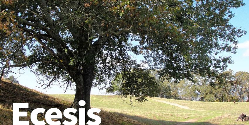
SERCAL Board of Directors
       Kevin MacKay ICF International
PRESIDENT
Kevin.Mackay@icfi.com
            Matt James Coastal Restoration
PAST PRESIDENT
Consultants matt@crcsb.com
                       RECON
PRESIDENT ELECT Pete Tomsovic
Environmental, Inc.
ptomsovic@reconenvironmental.com
       Karen Verpeet H.T. Harvey & Associates
SECRETARY
kverpeet@harveyecology.com
        Dave Hubbard Coastal Restoration
TREASURER
Consultants dave@crcsb.com

Directors
REGION 1 Ralph Vigil Restoration Resources
r.vigil@restoration-resources.net — NORTHERN
INTERIOR (Lassen, Modoc, Shasta, Siskiyou, Trinity)

REGION 2
      Harry Oakes ICF International
Harry.Oakes@icfi.com — SACRAMENTO VALLEY (Butte,
Colusa, Glenn, Lake, Sacramento, Sutter, Tehama, Yolo, Yuba)

REGION 3 Gregory Andrew Marin Municipal Water                     Looking south down the Yolo Bypass from over Interstate 80 during a flood event in April 2012.
District gandrew@marinwater.org — BAY AREA
(Alameda, Contra Costa, Marin, Napa, San Francisco, San
Mateo, Santa Clara, Solano, Sonoma)                            Lower Yolo Tidal Marsh continued
REGION 4
       Carl Jensen ICF International
Carl.Jensen@icfi.com — SAN JOAQUIN VALLEY (Amador,             agencies, federal agencies, and stakeholders have worked to develop and implement a
Calaveras, Fresno, Kern, Kings, Mariposa, Madera, Merced,      long-term program for improving the Sacramento-San Joaquin Delta’s ecosystem health.
San Joaquin, Stanislaus, Tulare, Tuolumne)                     A primary venue for that effort was the CALFED Bay-Delta Program (CALFED), which
REGION 5Pete Tomsovic RECON Environmental,                     was approved in 2000 to achieve four interrelated objectives: levee system integrity,
Inc. ptomsovic@reconenvironmental.com —                        ecosystem restoration, water supply reliability, and improved water quality.
SOUTH COAST (Los Angeles, Orange, San Diego, Ventura)
                                                               Subsequent to CALFED, the Delta Vision plan was created by then-Governor Arnold
REGION 6Mauricio Gomez South Coast Habitat                     Schwarzenegger to “develop a durable vision for sustainable management of the Delta” so
Restoration mgomez@schabitatrestoration.org
                                                               that the Delta can support environmental and economic functions important to the
— CENTRAL COAST (Monterey, San Benito, San Luis Obispo,
Santa Barbara, Santa Cruz)
                                                               people of the state of California. The Delta Vision Strategic Plan was issued in 2007 and
                                                               contains recommended strategies and actions which include: restoring tidal and riparian
REGION 7
      Ross Taylor Ross Taylor & Associates
rossntaylor@sbcglobal.net — NORTH COAST
                                                               habitats and increasing frequency of floodplain inundation, improving migratory
(Del Norte, Humboldt, Mendocino)                               corridors, addressing invasive species, relocating export diversions and implementing
                                                               conveyance improvements, revising flow standards and operating criteria, and improving
REGION 8
     David Shaw Balance Hydrologics, Inc.
dshaw@balancehydro.com — SIERRA (Alpine,
                                                               water quality. Many of these actions are now being pursued through the proposed Bay
El Dorado, Inyo, Mono, Nevada, Placer, Plumas, Sierra)
                                                               Delta Conservation Plan (BDCP).
REGION 9
      Mark Girard HRS/Dudek                                    Nearing completion of its planning phase, the BDCP is being prepared by a group of
mgirard@hrs.dudek.com — SOUTHERN INTERIOR                      local water agencies, environmental and conservation organizations, state and federal
(Imperial, Riverside, San Bernardino)                          agencies, and other interest groups in compliance with the federal Endangered Species
                                                               Act and the California Natural Communities Conservation Planning Act. When
SERCAL Guilds
                                                               complete, the BDCP will provide the basis for issuing endangered species permits for the
COASTAL HABITAT / NO. CAL
                    Will Spangler H.T. Harvey                  operation of the State Water Project and Central Valley Project over the following 50
& Associates wspangler@harveyecology.com
                                                               years. The heart of the BDCP is a long-term conservation strategy that sets forth actions
UPLAND HABITAT / NO. CAL
                    Harry Oakes ICF                            needed for a healthy Delta, building upon the framework established through the
International Harry.Oakes@icfi.com                             CALFED and Delta Vision processes. The draft biological goals and objectives in the
WETLAND & RIPARIAN / SO. CAL
                        Matt James Coastal                     BDCP call for substantial commitments to restore natural habitats, including up to
Restoration Consultants matt@crcsb.com                         65,000 acres of tidal wetland and associated estuarine and upland habitats distributed
              ____________________
                                                               across the Delta; up to 10,000 acres of seasonally inundated floodplain habitat along
                            Susan Clark Coy
      ADMINISTRATIVE DIRECTOR
                                                               major channels; and enhancement of floodplain in the Yolo Bypass.
              smclark@lightspeed.net
          2701 20th St., Bakersfield 93301                     Location
        tel. 661.634.9228 fax 661.634.9540
                                                               The Lower Yolo Project site is located at the southern end of the Yolo Bypass floodway
    NEWSLETTER EDITOR & WEBSISTER Julie St. John
                                                               directly to the north of Liberty Island and near the north end of the Cache Slough
                 julieDesign@cox.net
                                                               complex. The Yolo Bypass is a levee-protected, 59,000-acre floodplain west of the lower
   AND A HUGE THANK      YOU TO RETIRING WEBMASTER
                  Steve Newton-Reed                                    Ecesis 2 Fall/Winter 2013 Volume 23, Issue 3
Looking west across the Yolo Bypass across the project site.

Sacramento River. The 41-mile-long bypass routes Sacramento               2,134 acres will be restored, enhanced and/or preserved aquatic and
River floodwaters away from heavily developed urban and suburban          terrestrial species habitat. The highlight of the project is restoration
areas and onto minimally developed farmland. Land uses within the         of approximately 1,672 acres of tidal freshwater marsh habitat.
Yolo Bypass are managed to facilitate flood flow conveyance. Land
                                                                          The goals and objectives of the project are to:
uses within the Bypass consist of the state-owned Yolo Wildlife Area
(16,700 acres) and privately owned agricultural lands, all of which          Enhance regional foodweb productivity and export to Cache
are subject to flood flow conveyance easements that restrict                 Slough complex in support of delta smelt (Hypomesus
development. The bypass is predominantly used for annual                     transpacificus) recovery
agricultural crops and some grazing. The Yolo Wildlife Area is
managed for emergent wetland vegetation. Bordering the Yolo                  Provide rearing habitats for out-migrating salmonids
Bypass on the east is the Sacramento Deep Water Ship Channel.                Provide rearing, breeding, and refuge habitats for a broad range
The Project site contains a ranch compound in the northwest                  of aquatic and wetland-dependent species that utilize or depend
corner of the property (including small seasonal residences, barns,          upon the combination of Delta aquatic and terrestrial habitats
other outbuildings, and corrals) and irrigated pasture on the                Suitable habitat for establishment of diverse native plant
remainder of the site. The topography of the Project site is primarily       communities including rare plants
flat, with an almost imperceptible slope descending from the
northwest to the southeast. Much of the site is at elevations above          Minimize potential for colonization by Brazilian waterweed
modern mean higher high tide (+6.5 ft. NAVD881), with elevations             (Egeria densa)
ranging between +6.5 to +15 ft. NAVD88. Approximately one-                   Preserve existing topographic variability to allow for habitat
quarter of the site topography is within intertidal elevation ranges of      succession and resilience against future climate change
+2 to +6.5 ft. NAVD88. Many areas within the site are currently
pastures that have been graded to drain to agricultural drainage          Because of its location at the Sacramento-San Joaquin Delta margin,
ditches. Before being diked off for agriculture in the early 1900s, the   the Project site provides an opportunity to restore extensive
Project site likely contained a matrix of grasslands, seasonal            wetland-upland transitional habitats, and can accommodate sea
wetlands, perennial open water backwater lake features, and tidal         level rise for many decades as marsh expands landward.
marsh. The Project site is now primarily used for seasonal cattle         Design and Construction
grazing except during the rainy season, when it provides flood
conveyance capabilities as part of the Yolo Bypass. To prevent tidal      Utilizing historical ecological information recently developed by the
flooding, the hydrology of the site is intensively managed through a      San Francisco Estuary Institute, the Project seeks to utilize the site’s
series of levees, flood/drainage ditches, tide gates, flap gates, and     unique position on the landscape. According to the Institute, the
other associated infrastructure.                                          Project site historically held a uniquely rich location at the
                                                                          intersection of the Putah Creek alluvial fan, historic Yolo Basin
Goals and Objectives                                                      floodway, and north Delta tidal marshes. The proposed Project
The overall Lower Yolo property, which is owned by Westlands              seeks to partially restore some of these ecological functions in the
Water District, is approximately 3,423 acres, of which approximately      current, highly altered landscape and restore as much of the historic
                                                                          hydroperiod diversity as possible. This includes reconnecting the
1   North American Vertical Datum of 1988                                                                                        continued next page
                                                         www.sercal.org 3 Ecesis
Lower Yolo Tidal Marsh
continued

historic lake features with surrounding natural
tidal waterways and removing obstructions to
tidal inundation to allow seasonal and tidal
waters to drain slowly through the marsh plains.
The proposed Project also seeks to maximize
ecological productivity by enhancing resiliency,
diversity, and regional integration. Utilizing the
existing topography and irrigated pasture
infrastructure at the site, the proposed Project
would increase hydraulic residence time through
increased surface flow complexity and discharge
distance to receiving waters. These Project
features would maximize resiliency in the face of sea level rise and    Looking south across the Lower Yolo site with Mount Diablo in the background.
regional stressors such as changes in tides, floods, salinity mixing,
and invasive species. Depending on the seasonal and regional              tidal marsh habitat and 49 acres of riparian habitat; removing
hydrology, water would come from daily tidal exchange or from             agricultural irrigation from approximately 385 acres surrounding
seasonal inundation during flood events in the Yolo Bypass.               the restored wetlands (fringe tidal wetlands); and relocating and
                                                                          installing several water control structures and some irrigation and
Specific actions associated with the proposed Project include:
                                                                          drainage ditches. Approximately 58,000 cubic yards of soil will be
restoring approximately 1,672 acres of tidal marsh, including 4 acres
                                                                          excavated from the restoration area and stockpiled on existing
of tidal channels and swales; enhancing approximately 28 acres of
                                                                          agricultural fields in the northwest corner of the property, behind
                                                                          restricted-height levees.
                                                                          Tidal restoration and enhancement would be accomplished by
  Our many thanks to our generous                                         eliminating or moving existing water control infrastructure
    2013 conference sponsors…                                             elements or installing new elements, excavating notches in existing
                                                                          internal and perimeter berms, and creating new tidal channels and
                                                                          swales to connect restoration and enhancement areas to existing
                                                                          tidal waters adjacent to the site. High tides would be temporarily
                                                                          captured behind existing berms that are part of the irrigated pasture
                                                                          landscape that now exists on the Project site. Water will discharge
                                                                          from the site though the existing irrigated pasture ditch network via
                                                                          overland flow, and through swales that will be cut to drain the
                                                                          deepest parts the existing landscape. Depth of the swales will vary
                                                                          in order to vary the hydroperiod within the associated drainage area
                                                                          and test different residency time hypotheses. Removing irrigation
                                                                          control structures will greatly reduce the potential for fish
                                                                          stranding. In addition, grazing will be restricted within the
                                                                          restoration footprint through the seasonal use of exclusion fencing.
                                                                          Surrounding the restored wetlands will be an additional 385 acres of
                                                                          transitional uplands on which agricultural irrigation will be
                                                                          discontinued. Seasonal cattle grazing will be utilized within this
                                                                          wetland buffer zone as a vegetation management tool. To ensure
                                                                          that irrigation and drainage needs of the remainder of the site and
                                                                          of adjacent properties are maintained, the one tide gate will be
                                                                          relocated. Areas on the property that are outside of the Project
                                                                          footprint will remain in their current condition and continue to
                                                                          support agricultural operations following Project implementation.
                                                                          The final Environmental Impact Report for the project has been
                                                                          certified and regulatory permits for project construction are
                                                                          currently being reviewed by the relevant public resource agencies.
                                                                          Construction is scheduled for the summer of 2014.

                                                              Ecesis 4 Fall/Winter 2013 Volume 23, Issue 3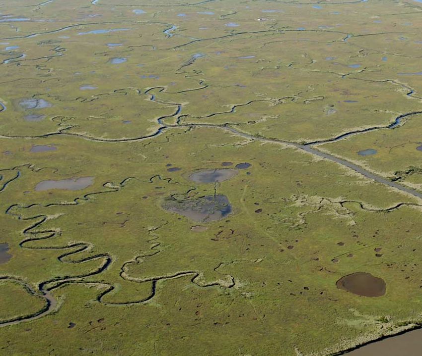
Sneak Preview: SERCAL 2014
                Please join us for SERCAL’s return to the beautiful Sonoma Valley in May 2014. We have
                a number of exciting field tours and informative technical sessions planned, including:
                Full day field tours showcasing local projects that are improving fish passage and aquatic
                habitat in the Lagunitas Creek Watershed, restoring marshes along San Francisco Bay and on the
At the          outer coast, and implementing innovative approaches for integrating habitat restoration with

Wells Fargo     agriculture, flood protection, and recreation in Marin and Sonoma Counties.

Conference      Technical Sessions bringing together speakers actively involved in:
                                                       Estuarine Restoration
Center in the                            Restoration for Special-Status Fish and Wildlife
lovely wine                              Upland Habitat Restoration and Management
country of                                        Riparian Habitat Restoration

Santa Rosa                                   Project Implementation and Monitoring
                                          Integrating Restoration and Other Land Uses

                Opportunities to meet and share perspectives with other restoration practitioners
                over coffee, lunch, and beer/wine, during local field tours, or while viewing poster presentations.
                Hope to see you there! — Kevin Mackay, SERCAL President and 2014 Conference Chair

                             Save the Dates — Tuesday May 13,
                              Wednesday May 14, & Thursday May 15

     Our many thanks to our generous 2013 conference sponsors…

                               www.sercal.org 5 Ecesis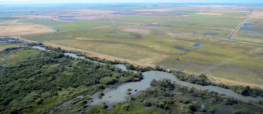
A Big Step in the Right Direction:
U.S. Army Corps of Engineers 2013 Regional Mitigation and Monitoring Guidelines
by Michelle Mattson, Southern California Biology Team Manager, ICF International. Michelle.Mattson@icfi.com

In August 2013, the South Pacific Division of the U.S. Army           complicated the effort due to the vast diversity of ecological
Corps of Engineers (Corps) released draft Regional                    conditions, aquatic resources and sometimes conflicting regional
Compensatory Mitigation and Monitoring Guidelines                     goals and state regulations that govern land and water uses. So
(Guidelines) for unavoidable impacts to aquatic resources. The        although not perfect, these Guidelines are a big step in the right
Guidelines were designed to help the regulated public and             direction.
mitigation/restoration practitioners comply with the 2008
                                                                      The Guidelines supplement the Mitigation Rule by providing
national regulations (“Mitigation Rule”). The South Pacific
                                                                      regionally-specific information and tools for developing the
Division encompasses a large geographic area — Arizona,
                                                                      twelve required elements of a Compensatory Mitigation Plan. Of
California, Nevada, Utah, New Mexico and parts of Colorado
                                                                      particular interest to SERCAL members may be Sections 3.4 and
and Texas. The Los Angeles, Sacramento, San Francisco, and
                                                                      4.2.2, Amount of Compensatory Mitigation; Section 4.3, Site
Albuquerque Districts have been working together for several
                                                                      Selection; and Section 4.4, Design, including subsections on
years to develop these Guidelines, as well as other tools to aid in
                                                                      recommendations and potential pitfalls. Historically, the amount
the identification, design, implementation, and monitoring of
                                                                      (e.g. mitigation ratio) of compensatory mitigation required by
compensatory mitigation sites. These efforts have been led by Dr.
                                                                      regulatory agencies has been inconsistent, particularly when
Daniel Swenson, North Coast Section Chief, Los Angeles
                                                                      ratios have varied greatly across districts or between regulators
District. It was an enormous effort corralling busy State and
                                                                      within a single district. Section 3.4 describes the eight variables
Federal regulators to participate in meetings and then facilitate
                                                                      Corps regulators will consider in setting mitigation
discussions between people with varying degrees of restoration
                                                                      requirements. The standardized approach for evaluating these
and mitigation experience. In addition, the large geographic area

             Our many thanks to our generous 2013 conference sponsors…

                                                           Ecesis 6 Fall/Winter 2013 Volume 23, Issue 3
variables is provided in a
                                       Coming soon to a screen near you…
separate guidance document             By the time you receive this issue of Ecesis, the new SERCAL website
referred to as the Standard
Operating Procedure for
                                       should be up and running... check it out and take it for a spin!
Determination of Mitigation            And stay tuned to sercal.org… there’s more to come!
Ratios (“Mitigation Ratio
Checklist”). The Mitigation
Ratio Checklist is a tool for
comparing the impact site to
the proposed mitigation site(s).
Supporting information is
provided for each variable in
the Guidelines, expressing why
each should be considered in
developing a mitigation plan.
These include the type,
condition, and location of the
affected jurisdictional resources
at the impact site relative to
those at the proposed
mitigation site; the risk and
uncertainty of successfully
implementing the mitigation
site; and whether the temporal
and indirect jurisdictional
impacts are adequately
addressed.
Site selection, as required in
Section 4.3, is a key part of the
process needed to restore or
establish a natural and
sustainable aquatic resource. As referenced in the Guidelines, it is   site-specific data. The design recommendations include choosing
well documented that the type of aquatic resource proposed             a location and design with buffer areas, connectivity with other
should be ecologically suitable to the location, taking into           aquatic resources or natural open space, sources of natural
consideration the physical, hydrological, and biological processes     hydrology, and soils conducive to the type of aquatic resource
needed for the aquatic resource to function naturally.                 and target vegetation community. Reference sites in proximity to
Unfortunately, this has not frequently been the practice for           the mitigation site are recommended for use in setting realistic
proposed mitigation sites. Often, mitigation sites are proposed on     performance standards and to provide a basis for comparison
landscapes that are convenient or available and cost-effective to      during site development, particularly during abnormal weather
the permittee, with little consideration to landscape position,        years or in the face of a changing climate.
physical or hydrological processes, and surrounding land uses.
                                                                       The Guidelines are intended to standardize compensatory
Based on my recent experience as a Corps regulator in the Los
                                                                       mitigation procedures throughout the SPD region by providing
Angeles District, it is my opinion that poor site selection is the
                                                                       definitions for commonly used terms and simple guidance for
primary reason for mitigation failure. These Guidelines should
                                                                       mitigation plan requirements in the Mitigation Rule. Also
help to reverse that trend.
                                                                       provided is an outline for developing mitigation plans that, if
Section 4.4 of the Guidelines discusses design and the                 followed, will address the 12 elements required by the Mitigation
development of the mitigation site work plan, including basic          Rule, and example tables for reporting data that SPD requires.
recommendations for design approach. Although it does not              These Guidelines are a substantial step in the right direction to
cover all of the information needed to design a successful             providing both regulators and the regulated public with clear
mitigation site — or an exhaustive list of all the problems that       expectations for planning and implementing successful
practitioners can experience — it does cover some of the most          compensatory mitigation.
common mistakes. There is a statement that a conceptual design
needs to provide enough site-specific data to provide the Corps
with confidence the proposed project would fulfill its objectives.
After the conceptual plan is approved, the final work plan must
include grading and planting designs which require substantial

                                                 www.sercal.org 7 Ecesis
Our many thanks to our generous 2013 conference sponsors…

                       Ecesis 8 Fall/Winter 2013 Volume 23, Issue 3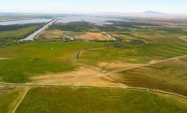
Natural                          October 18-19 Theodore Payne
                                                        Foundation Fall Plant Sale: 10459

                      Resource                          Tuxford St., Sun Valley 91325.
                                                        www.theodorepayne.org

                       Events                           October 19-20 San Elijo Lagoon
                                                        Nature Center: Not So Scary Estuary
                                                        for Kids, 1-4pm. www.SanElijo.org

                      Calendar                          October 20–November 2 Bringing
                                                        Back the Natives Garden Tour (BAY
                                                       AREA): Fall Plant Sale and Event Series.
                       Stay tuned to                   www.bringingbackthenatives.net

                       sercal.org               October 24 California Native Grasslands
                                                Association (CNGA) Workshop: Native
                                 o              Grasslands Restoration & Revegetation
                        Call for Abstracts      Projects, Lake Solano Nature Center with
                                                field visit to upland restoration site west of
                        NOV 2013 (DUE FEB 1)
                                                Winters. www.cnga.org
                                o
                                                October 26 Field Tour of Audubon Bobcat
                      Invitation to Sponsor     Ranch: www.brownpapertickets.com/
                           JANUARY 2014         event/447395
                                o               January 22-23 9th Annual California
                      Registration Brochure     Rangeland Conservation Coalition
                           FEBRUARY 2014        Summit: Oakdale. www.carangeland.org

Our many thanks to our generous 2013 conference sponsors…

                      www.sercal.org 9 Ecesis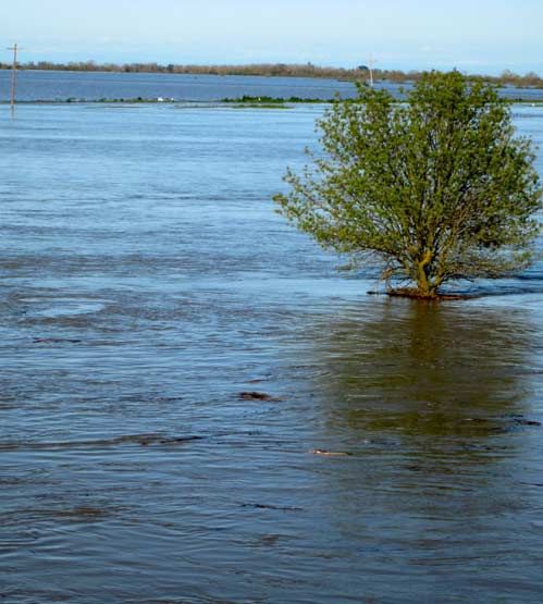
Many Thanks to Our 2013 Special Members…

                $1,000 Summit Circle
                       DUDEK Encinitas                                                  $100 Sustaining
$500 Sustaining Business              $250 Contributing Business                            Individual
                                                                                        R.C. Brody ICF
Westervelt Ecological Services        Northwest Hydraulic Consultants,
                                                                                         International Los Angeles
 Sacramento                            Inc. West Sacramento
                                                                                        Kevin MacKay ICF
Integrated Environmental              Hedgerow Farms Winters
                                                                                         International San Jose
 Restoration Services Tahoe City      E. Read & Associates Orange
                                                                                        Harry Oakes ICF
S & S Seeds, Inc. Carpinteria         Helix Environmental La Mesa                        International Sacramento
RBF Consulting Irvine                 Burleson Consulting, Inc. Folsom                  Harold C. Appleton
RECON San Diego                       URS Santa Barbara                                  Prunuske Chatham, Inc.
                                      cbec, inc., eco engineering West                  Liza Prunuske Prunuske
                                       Sacramento                                        Chatham, Inc.

 Welcome New Members
        ( AS OF 9 OCTOBER 2013)        Have you moved?
 Kjersten Walker Berkeley              Are you planning to?
 Jim Alford Sacramento                 Don’t forget to let us know your new address. Even
 Christine Moen Temecula               if you dutifully file a forwarding order, it doesn’t
                                       necessarily mean the post office will comply with
                                       that order. We are seeing more mail returned than
 Did you get your membership           ever before.
 renewal in the mail last month?
                                       Save SERCAL the time and additional postage and
 Memberships expire at the end of
                                       yourself the headache of delayed mail — send a
 every year. Beat the holiday rush     postcard or email the SERCAL Administrative Office
 — go through that stack of mail or
 go online and renew now!
                                       with your new contact information. It will make
                                       everybody happy!
                                                                                              Thank you !

          Our many thanks to our generous 2013 conference sponsors…

                                           Ecesis 10 Fall/Winter 2013 Volume 23, Issue 3
SERCAL 2014 Membership Application/Renewal Form
Annual Membership Dues SERCAL’s quarterly newsletter, Ecesis, is received
with ALL rates. Additional member benefits include:
INDIVIDUAL BUSINESS Copies of each Number of discounted
$15 STUDENT $50 NONPROFIT ORG. Category
_____________________ Ecesis issue **
____________ rates at SERCAL events
___________________
$45 REGULAR $250 CONTRIBUTING * Nonprofit Org. 2 1
$80 JOINT SERCAL +CNGA (discounted) $500 SUSTAINING * Contributing Business 3 3
$100 SUSTAINING * $1,000 SUMMIT CIRCLE * Sustaining Business 4 4
* Receive quarterly recognition in Ecesis Summit Circle 6 6
**Please list the additional names to be included on the
Ecesis mailing list in the space below this form.
________________ + _____________________ = ___________________
DUES ADDITIONAL SUPPORT TOTAL AMOUNT PAID
_______________________________________________________________________________________________________________________
NAME DATE
_______________________________________________________________________________________________________________________
COMPANY/AFFILIATION
_______________________________________________________________________________________________________________________
ADDRESS
_______________________________________________________________________________________________________________________
CITY / ZIP / COUNTY
_______________________________________________________________________________________________________________________
PHONE
_______________________________________________________________________________________________________________________
EMAIL
PAYMENT OPTIONS:
m Check enclosed (Made payable to SERCAL)
m Please charge my: m Visa mMasterCard Card No.: _ _ _ _ - _ _ _ _ - _ _ _ _ - _ _ _ _ EXP: _ _ / _ _
Card Billing Address if different than mailing address listed above:
_______________________________________________________________________________________________________________
MAIL TO: SERCAL Administrative Office, 2701 20th St., Bakersfield CA 93301
SCAN & EMAIL TO: smclark@lightspeed.net SECURE FAX: 661.634.9540
**Additional names (if applicable) to be included on the Ecesis mailing list:
www.sercal.org 11 Ecesis2701 20th Street, Bakersfield CA 93301-3334
RETURN SERVICE REQUESTED
Check the mailing label
for your membership
expiration date
Stay tuned: SERCAL 2014
See page 5 for the sneak preview!
At the Full-day Field Tours Watch your mailbox
Wells Fargo and sercal.org:
Technical Sessions
Conference Estuarine Restoration Call for Abstracts
Center in the Restoration for Special-Status Fish and Wildlife November 2013
lovely wine Upland Habitat Restoration and Management
o
Riparian Habitat Restoration
country of Call for Sponsors
Project Implementation and Monitoring
Santa Rosa Integrating Restoration and Other Land Uses January 2014
o
Opportunities to meet and
share perspectives with other Call for YOU!
restoration practitioners February 2014You can also read