MIT International Center for Air Transportation - DSpace@MIT
←
→
Page content transcription
If your browser does not render page correctly, please read the page content below
PRELIMINARY ANALYSIS OF POTENTIAL ADS-B
USER BENEFITS FOR HAWAIIAN HELICOPTER AIR
            TOUR OPERATORS

         Edward Lester, R. John Hansman

               Report No. ICAT-2007-1
                     June 2007

MIT International Center for Air Transportation
      Department of Aeronautics & Astronautics
       Massachusetts Institute of Technology
            Cambridge, MA 02139 USA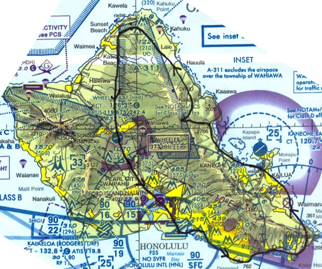
Preliminary Analysis of Potential ADS-B User Benefits for Hawaiian
                       Helicopter Air Tour Operators

                      Edward Lester, Prof. R. John Hansman

                MIT International Center for Air Transportation

                                     June 5, 2007

Motivation

In response to the September 24, 2004 crash of a Bell 206B helicopter being
operated under CFAR Part 91 by Bali Hai Helicopter Tours, Inc on the island of
Kauai in Hawaii the National Transportation and Safety Board (NTSB) issued
nine recommendations to the Federal Aviation Administration (FAA). [1]
Several of those recommendations relate to Automatic Dependent Surveillance-
Broadcast (ADS-B) technology including:

      Accelerate the implementation of automatic dependent surveillance-broadcast
      (ADS-B) infrastructure in the State of Hawaii to include high-quality ADS-B
      services to low-flying aircraft along heavily traveled commercial air tour routes.
      (A-07-25)

ADS-B ground infrastructure is currently planned to be installed in Hawaii
between 2010 and 2013 as part of the National Airspace System (NAS) wide
implementation of ADS-B. Current plans call for ADS-B coverage to be focused
on areas of existing radar coverage. However, a large majority of the
commercial air tour routes are conducted in regions outside of existing radar
coverage due to mountainous terrain and limited radar facilities. The NTSB
recommendation would therefore require a change to the ADS-B
implementation plans.

In addition the NTSB recommended mandating ADS-B equipment for air tour
operators:

      Require that Hawaii air tour operators equip tour aircraft with compatible
      automatic dependent surveillance-broadcast (ADS-B) technology within 1 year of
      the installation of a functional National ADS-B Program infrastructure in
      Hawaii. (A-07-26)

This would also require a change in ADS-B implementation. Currently, the FAA
does not plan on mandating ADS-B out equipage until around 2020, and then
only in class A, B, and C airspace. In Hawaii, only Oahu and Maui have class B or
class C airspaces, thus many air tour operators would not be required to equip
with ADS-B out under the existing plan.

                                        2 of 32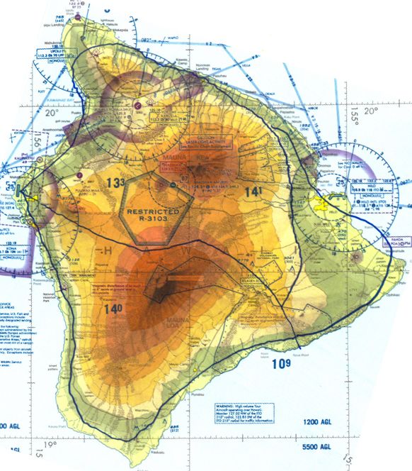
An alternative approach to address the NTSB recommendations outside an early
mandate would be to establish a Memorandum of Agreement (MOA) similar to
that currently established for the Gulf of Mexico with Helicopter Association
International (HAI). The MOA established a collaborative agreement, where the
FAA will provide ADS-B ground infrastructure and separation services for
offshore helicopters, while the HAI operators agreed to equip their helicopters
and grant use of off-shore oil platform space for ADS-B equipment. If a similar
agreement could be reached between the FAA and Hawaiian air tour operators,
the ground infrastructure could be in place and operators equipped sooner than
2020, and the ADS-B implementation could attempt to provide focused benefits
for Helicopter air tour operators.

The objective of this study is to identify helicopter air tour operator
requirements and potential ADS-B applications which would provide user
benefits sufficient to justify early equipage with ADS-B technology. In order to
identify user requirements a series of focused interviews, surveys and a flight
observation were conducted during a joint FAA / HAI Helicopter Air Tour
safety summit in Honolulu on May 22-23, 2007.

Method

User input was obtained through a survey instrument and focused interviews
with participants in the Joint FAA / HAI Helicopter Air Tour safety summit.

The conference was attended by over 50 representatives from 19 Hawaiian air
tour operators, representing a significant majority of the helicopter air tour
operators in Hawaii (80% of the operators listed on the Hawaii Visitors and
Convention Bureau website [2] attended, plus an additional 9 operators). The
participants consisted of Chief Pilots, Directors of Operations, Maintenance
Directors, Presidents, and CEOs.

ADS-B was briefed to the participants by the FAA Surveillance Broadcast
Systems program office. In conjunction with the briefing, written surveys were
distributed to the air tour operators. A copy of the survey instrument is
presented in Appendix 1. Surveys were completed by 44% of the Hawaiian
helicopter air tour operators in attendance as well as two surveys completed by
fixed-wing air tour operators in Hawaii, and one completed by a Hawaiian FSDO
inspector who is also a commercially rated helicopter and fixed-wing pilot.

Focused interviews were conducted with sixteen representatives of air tour
operators using the interview question protocol in Appendix 2 as a guide. Due
to intensive nature of the summit and the limited time to interview many of
these interviews were conducted in groups. As part of the interviews, operators
were asked to trace their typical flight routes on FAA sectional charts. A
compilation of these sketched routes can be found in Appendix 3.

                                     3 of 32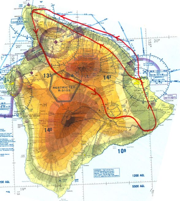
In total, feedback was collected from 84% of the Hawaiian air tour operators
present at the safety summit. The survey and interview participants are listed in
Appendix 4.
In order to assess operational considerations, a site visit and flight observations
were conduced during a typical air tour flight around the island of Oahu. The
flight was conducted on an Aerospatiale AS350BA “A-Star” helicopter, operated
by Makani Kai Helicopters departing from Honolulu International Airport
(Figure 1). During this site visit additional input was solicited from the president
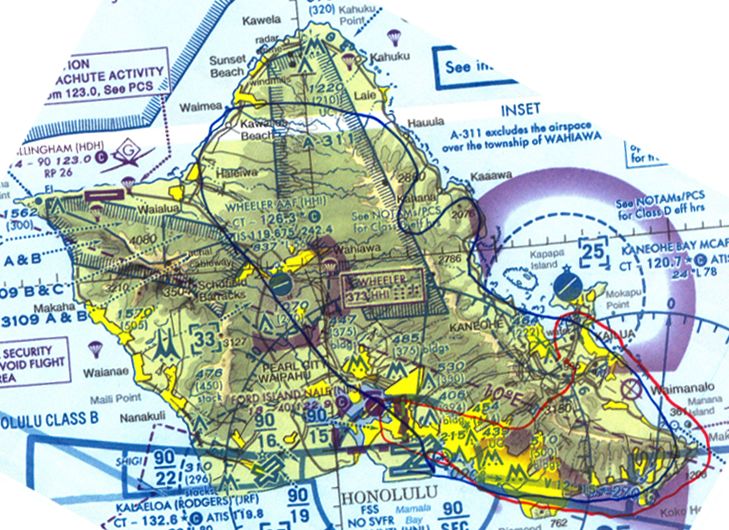
and operations manager. The flight route was typical of a normal tour and is
shown in Figure 2.
Figure 1: AS350 Helicopter Operated by Makani Kai Helicopters
4 of 32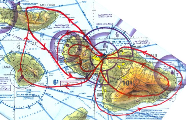
Figure 2: Standard Oahu tour route flown during the observational flight

Operational Environment

Air tour operators in Hawaii conduct their business in a unique operating
environment, based on details obtained during the interviews and field
observations. The air tours usually consist of flights of fifteen minutes to an
hour, departing and arriving from the same airport or heliport with upwards of
6 passengers. The tours are conducted primarily in Aerospatiale ES350 “A-Star”
and Bell 206 single turbine helicopters, however at least one operator uses piston
powered R44s and another uses Augusta A109 twin turbine engine helicopters.

The tours are conducted over the coast, over mountainous terrain, and in small
canyons. A sample route map for the island of Kauai can be seen in Figure 3. A
complete set of maps for routes flown by the interviewees is in Appendix 3. The
operators must also deal with the low clouds and rain which are common with
the Pacific trade-wind driven weather patterns on the Hawaiian Islands, where
moist air from the ocean is driven up the windward slopes creating a cloud layer
below a larger scale temperature inversion. [3] This causes larges amounts of

                                           5 of 32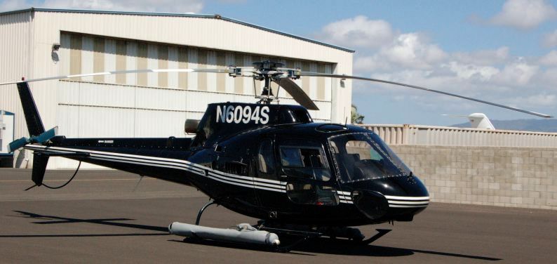
rain in some areas of the islands, with the rainiest part being Mt. Waialeale on
Kauai with an annual average rainfall of about 450 inches. This contrasts greatly
with the leeward coasts and high slopes which can see an annual rainfall of less
than 10 inches.

  Figure 3: Variety of air tour routes on Kauai. The coastal routes are used during periods of low
                            ceilings, while the inland routes are preferred.

Compounding the weather impacts on Hawaiian helicopter operators is the
minimum altitude restriction placed on Hawaiian air tour operators under CFAR
Part 136 Appendix A (formally SFAR 71). This restriction, in effect since 1996,
restricts air tour operators to a minimum altitude of 1500 feet, as opposed to the
standard minimum altitude of 300 feet for Part 135 helicopter operators (CFAR
135.203 b). While the full grounds for this rule creation were not investigated,
anecdotal accounts indicate that it was driven by both safety and noise
abatement concerns. This restriction limits the ability of tour operators to launch
with low clouds. Unfortunately the 1500’ rule may actually increase noise impact
since when the weather deteriorates, operators fly over the low, populated
coastal areas.

Based on the interviews and comments during the safety summit question and
answer period, most operators have FSDO-granted deviations from the 1500’

                                             6 of 32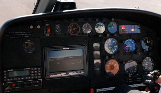
rule in certain places, allowing 1000’ or 500’ ground clearance. However, the
standard is still 1500’ for non-scenic segments of the route.

The NTSB has concerns that the “SFAR 71 altitude restrictions may increase the
potential for inadvertent encounters with could layers”, yet the NTSB
determined that there is not enough data to asses the significance of this
relationship. One operator noted that there have been 19 fatalities on the island
of Kauai alone since the enactment of SFAR 71, and directly attributes them to
the altitude restriction and the increased chance of VFR into IMC encounters.
While this obviously stretches the diverse causes of the accidents, it illustrates the
operators strong safety concerns with the 1500’ rule.

                                       7 of 32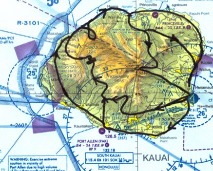
Survey Results

Benefits

In general helicopters air tour operators in Hawaii were receptive to the
implementation of ADS-B technology in Hawaii, especially after they learned
more about the technology. 100% of the survey respondents saw value in ADS-
B services (question 7, Appendix 1), but 22% wrote that the benefits would be
“limited” or “little.”

Survey participants were presented with a list of potential applications to indicate
if they would have “significant benefits”, “limited benefits”, “no benefits” from
the given application for their operation considering financial, efficiency, safety,
and other operational benefits. As can be seen in Figure 4, the applications with
strongest benefits from surveys, with 44% or more of the respondents indicating
significant benefits, are Company Flight Tracking, Increased VFR Flight
Following, Enhanced Visual Acquisition, Cockpit Assisted Visual Separation
(CAVS), and Cockpit Datalink Weather.

                                                                                                        Number of Respondents

                                                                                                    0   1     2     3     4        5   6
                          Radar ADS-B Non-Radar ADS-B
                         Out Applications Out Applications

                                                                          Company Flight Tracking
                                                                                   IFR Separation
                                                                  Increased VFR Flight Following
                                                                       Tower Surface Surveillance
                                                                 Tower Final Apch and Rwy Occ
                                                                  ATC Traffic Flow Management
                                                                        Increased Sector Capacity
                                                              Improved Company Flight Tracking
                                                                         Reduced Separation Stds
                                                                       Enhanced Visual Acquisiton
           ADS-B In CDTI

                                                                     Cockpit Surface Surveillance
            Applications

                                                                Cockpit Final Apch and Rwy Occ
                                                                       Cockpit Assited Visual Sep
                                                                Self Separation / Station Keeping
                                                             ADS-B In Datalink    Cockpit Weather
                                                               Applicatins       Cockpit Airspace

                                                                                                            Significant Benefits

    Figure 4: Survey results listing the number of respondents who marked
                    significant benefits for each application

                                                                                       8 of 32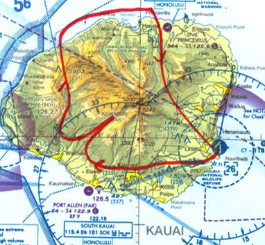
As expected, categories with IFR-only benefits, such as ATC traffic flow
management and increased sector capacity, had little appeal to the helicopter air
tour operators who operate in a VFR-only environment. Additionally, airport
applications for surface surveillance or final approach awareness are of little use
to helicopter operators.

In addition, when asked what other applications would provide benefits to the
air tour operations, respondents listed NOTAMs via datalink, two way
communications with the office (brought up by two survey respondents), make
and model of aircraft ahead for wake turbulence (from a fixed wing operator),
and tracking of aircraft for search and rescue and precautionary landings
(brought up by both an interviewee and another operator during the open
question and answer period). The communication and flight tracking
applications are analyzed in detail below in the Primary Focused Interview
Findings section.

Equipage

Approximately two thirds of operators have GPS equipped aircraft, but a
majority of those are VFR panel mounted units. The helicopter used for the
observational flight had VFR GPS, but it was not used at all by the pilot during
the air tour. No operators currently have MFDs, EFBs, or datalink weather
capabilities. Half of the operators have Mode-S transponders. Therefore, there
is almost no latent capacity to equip with ADS-B technology, besides the possible
upgrades to the Mode-S transponders for 1090-ES ADS-B out. Operators will
need to equip with GPS receivers certified to IFR standards in order to meet the
accuracy and integrity ADS-B performance requirements. Additionally,
operators will need to install certified displays for ADS-B in applications.

When asked “What are the factors which would affect your decision to
voluntarily equip with ADS-B or other avionics equipment?”, 75% of the
respondents for the question listed price or cost of avionics. In addition, 50%
listed weight as a concern. Similar responses were given to the question, “What
are the obstacles you see in equipping your fleet with ADS-B equipment?” Cost
(66% or respondents), Weight (55% or respondents), and Panel Space (55% or
respondents) were the key concerns. One participant wrote, “How much the
pilot weighs is already an issue”.

These concerns highlight the fact that operators will consider cost, size, and
weight of avionics in addition to benefits when deciding whether or not to equip.

                                      9 of 32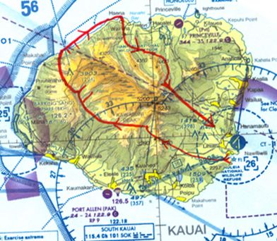
Other

A majority of the survey respondents projected that the number of air tour
operations would continue to increase in Hawaii, agreeing with the NTSB
statement that, “As Hawaii’s air tour industry continues to grow, increasing
numbers of aircraft will be flying over rugged, scenic terrain in a finite airspace.”
However, one operator noted that the number of passengers will always be
finite and the air tour industry will reach a limit. Another commented that he
wasn’t sure the number of aircraft will continue to climb. This also conflicts with
a statement by the president of a Maui-based tour operator, who wrote that the
“numbers indicate air tour in Hawaii are on the decrease not growing.” Finally,
the owner of a seaplane business in Honolulu for many years indicated that
there are a decreasing number of air tours in Oahu and fewer operators than 10
to 20 years ago. Further investigation is needed on the trends of the air tour
industry in Hawaii.

Primary Focused Interview Findings

Based on the focused interviews, the following four findings were consistent
across the all interviews and identified by at least 50% of the Hawaiian helicopter
operators interviewed.

   1. Hawaii specific weather products.

   Weather information is the greatest benefit of ADS-B technology cited by
   operators. One Director of Operations claimed that weather and lack of
   weather information are the leading causes of flight cancellations. This is
   consistent with the survey results, where all of the respondents found
   significant or limited benefits to cockpit weather information, with a majority
   selecting significant benefits.

   However, during the interviews it became apparent that the weather
   information needed by the helicopter air tour operators is not the same
   information needed for enroute fixed wing operations and reflected in the
   current ADS-B UAT datalink weather products. The METAR, TAF, and area
   forecast do not reflect the diverse and rapidly changing weather patterns in
   Hawaii. Radar and satellite images are useful for seeing approaching or
   building storms, but alone they do not provide enough data for a go/no go
   decision or in-flight decision making.

   Operators need to be able to identify weather around the corner and on the
   opposite side of an island, especially ceiling and visibility. Currently
   operators rely on sources outside of official National Weather Service
   products for obtaining weather information, obtaining a briefing from the
   flight service station, which usually consists of “VFR Not Recommended”, as
   a formality. From the ground, the operators call civilians living or working in

                                      10 of 32
key sites to ask about cloud heights and visibilities in relation to known
mountains and passes or call both military and civilian air traffic control
towers to speak with the controllers about the current local weather.
Once airborne, pilots relay informal pilot reports (PIREPs) over the common
traffic advisory frequency (CTAF), to other operators. However, these CTAF
communications are limited to line of sight communication, so reports of
weather on the other side of an island cannot be heard by the helicopters’
base of operations or even from a helicopter on one side of a ridge to the
other. This voiced based weather reporting system was observed during the
observational flight, along with details of an operator ahead waiting for a
pass to clear due to low clouds. The complex weather of the Hawaiian
Islands was also observed on the flight, with some areas of Oahu covered
with low clouds and rain (Figure 5) while others just a 15 minute flight away
(about 15 nm) had only scattered clouds (Figure 6).
Numerous operators expressed interest in the possibility of weather cameras
located in key sites for observing the weather. This came after a presentation
at the air safety summit on the FAA’s Weathercam project in Alaska, where
low cost weather cameras have been placed at key sites such as passes across
the state and the feeds are available free on the internet. Operators in Hawaii
claimed that a similar system would be invaluable in Hawaii due to the
quickly changing weather patterns and lack of weather reporting stations
along the air tour routes. Operators also suggested that if feeds from these
weather cameras could be made available to pilots in the cockpit through an
ADS-B datalink, the pilots could make better decisions about when to
continue a flight during marginal weather conditions. However, further
research needs to be done to see if there is bandwidth available on an ADS-B
datalink for transmission of images with sufficient resolution to identify
ceilings and visibilities at the weather camera locations.
11 of 32Figure 5: Low clouds and rain during the observational flight
Figure 6: Scattered clouds 15 minutes later and 15 nm away on the
observational flight
12 of 322. Voice communication enhancements installed with the ADS-B ground
infrastructure would be beneficial.
After weather information, the second most cited benefit of an ADS-B
infrastructure by operators was the potential for enhanced communication
coverage provided by ADS-B ground station installations. If ground stations
were installed to cover the low level tour routes, communication equipment
would also need to be installed to allow air traffic control (ATC) services.
Operators were less interested in talking with ATC as they were interested in
extending CTAF VHF coverage beyond line of sight in the rugged terrain to
allow communications with other helicopters for informal weather reports
and communication with the operator’s base of operations. VHF radio
repeaters could be installed at ADS-B ground stations allowing
communication beyond line of sight.
One operator was considering a satellite phone system for their helicopters
and thought that a service charge of $120 per month was reasonable for this
service. However, technical issues prevented the equipage. This indicates the
willingness of operators to find ways to communicate continuously with their
helicopters.
3. Flight tracking provides targeted benefits to air tour operators.
There is interest in the ability to track company helicopters through ADS-B
technology at the base of operations. This data could be used for flight
scheduling and observing deviations due to weather. One operator pointed
out during the question and answer period and another noted on the survey
the importance of locating helicopters quickly during precautionary or forced
off-airport landings. This search and rescue capability of ADS-B is especially
useful for helicopter operators who are not required to have Emergency
Locator Transmitters (ELTs) on board.
As the NTSB points out, ADS-B data could also be used for internal or FAA
investigations of potential altitude violations. The use of ADS-B reports by
the FAA for enforcement actions troubled at least two operators since they
claimed that pilots may just turn off the equipment to avoid enforcement.
4. Cockpit traffic displays only useful in regions of mixed flight activity with fixed
wing operators.
Hawaiian operators indicated less interest in cockpit traffic information than
cockpit weather information and enhanced voice communications. Currently
separation is based on standard air tour routes and conducted visually
through aided by of pilot position reports broadcast on the CTAF. This
voluntary voice based coordination of positions was observed during the
13 of 32observational flight. No operators currently utilize a Traffic Collision
Avoidance System (TCAS) or a Traffic Awareness System (TAS) on their
helicopters. The air tour operators maintain order by flying similar routes in
the same direction, maintaining a single file line.
The primary interest in traffic displays is in areas of mixed flight activity. As
one large operator put it, “The concern is not with other helicopter air tour
traffic but with fixed wing and military flights.” Occasionally, the helicopters
will be orderly orbiting over a scenic location like a crater, when a small
single engine fixed wing aircraft will fly right over the scenic location causing
the helicopters to “scatter”. Operators usually attribute this fixed wing
behavior to student pilots and pilots unfamiliar with the area, who don’t use
the CTAF position reporting. Operators also commented that military flights
occasionally transition the air tour routes without announcing since military
aircraft are usually only equipped with UHF communications equipment.
Military and fixed wing ADS-B equipage must be considered integral for an
ADS-B system in Hawaii to work for traffic awareness and separation.
Further study should be conducted to see if regions of mixed flight activity,
such as training areas and military routes, are under existing secondary radar
coverage so that TIS-B could be utilized to provide benefits to early adopters
of ADS-B in technology.
Other Focused Interview Observations
Applications should be tailored to VFR not IFR operations.
Helicopter operators in Hawaii operate exclusively under visual flight rules
(VFR). Thus many of the applications and benefits, such as merging and
spacing, that are proposed for fixed-wing operators in the IFR-based ATC
system, are not applicable to the VFR operations in Hawaii. This
consideration of VFR operations must be taken into account when
developing and ADS-B system in Hawaii that is of use to helicopter air tour
operators.
Both in the surveys and in the interviews, respondents, especially chief pilots,
expressed concern that the ADS-B technology would reduce the amount of
time pilots spend with their heads “out of the cockpit” maintaining attitude,
terrain separation, traffic separation, and weather separation visually, since
they would be looking at displays on the helicopter panel. Another concern,
cited by the director of the TOPS safety program for helicopters, is that
advanced cockpit technologies send the wrong message to pilots by allowing
them to get closer to IFR conditions with a false sense of comfort.
14 of 32 Select technologies should be bundled with ADS-B to encourage operator equipage.
While there does not appear to be sufficient support for voluntary ADS-B
equipage alone, when combined with other cockpit avionics, operators were
more receptive to ADS-B equipage. Based on question 15 of the survey
(Appendix 1) 44% of respondents would combine ADS-B with weather
datalink, CDTI, GPS navigation and a moving map. This is consistent with
the existing general aviation ADS-B installations done for the Capstone
project in Hawaii. A Terrain Awareness and Warning System (TAWS) was
also indicated as a bundled technology in the surveys, by only 33% of
respondents. This result is constant with interview results that found only
one operator currently has TAWS in their helicopters.
One important finding from the site visit was that many operators provide
live video footage to passengers on an instrument panel display as seen in
Figure 7. This footage comes from multiple cameras placed around the
helicopter, and is recorded for sale as a DVD to passengers after their flight.
Since panel space is so restricted in the cockpit, ADS-B moving map or
weather displays must be able to share a display with these video monitors.
The Hawaiian operator that has already equipped their helicopters with
TAWS, uses a display that can switch between video and the TAWS alerting
screen.
No operators indicated interest in Enhanced Vision System (EVS) such as
Forward-Looking InfraRed (FLIR) or with a 3D synthetic vision system. This
reflects the VFR-only operating environment of the air tours.
Figure 7: Air tour helicopter panel with video monitor
15 of 32 Operator concerns must be addressed prior to expecting any equipage.
Interview participants had a number of concerns. Like in the survey, size,
weight, and cost concerns were brought up. As pointed out earlier, some are
worried that additional avionics will keep pilots’ heads in the cockpit. One
chief pilot suggest that the avionics should be voice activated and that PIREPs
could be recorded and transmitted to other helicopters via the datalink so
that no time is spent heads down typing or reading written PIREPs. While
this may not be feasible with existing ADS-B technology, the concept
deserves researching for possible integration with future communication
technologies.
There are also concerns that ADS-B out would be used as a surveillance tool
to monitor and violate operators for CFAR 136 Appendix A minimum
altitude limit violations. It is difficult for operators to know altitude above
ground level or horizontal distance from terrain, thus the potential for strict
enforcement may cause an unwillingness of operators to equip.
Conclusions
There are ADS-B benefits to Hawaiian air tour operators, which center on useful
weather information and enhanced communication. Flight tracking and cockpit
traffic displays provide additional benefits for air tour operators. The major
concerns for operators are equipment price and the potential for FAA
enforcement actions based on surveillance data. When weighed with the
concerns, the benefits of ADS-B out or in are not enough by themselves for
widespread air tour operator voluntary equipage in Hawaii. However,
operators would be interested in voluntarily equipping with ADS-B technology if
it enabled relief from the CFAR 136 Appendix A restrictions or if it allowed the
general limit to be moved from 1500’ to 300’-500’.
Acknowledgements
The authors would like to thank all those who took the time to discuss air tour
operations and complete the survey. This study would not have been possible
without their honest comments and feedback.
References
1
Rosenker, Mark V. National Transportation Safety Board. “Safety Recommendation”. 27 Feb 2007.
1
http://www.gohawaii.com/
1
http://www5.ncdc.noaa.gov/climatenormals/clim60/states/Clim_HI_01.pdf.
16 of 32Appendix 1: Helicopter Operator Survey
17 of 32Helicopter Operator Survey
18 of 32Helicopter Operator Survey
19 of 32Helicopter Operator Survey
20 of 32Helicopter Operator Survey
21 of 32Appendix 2: Focused Interview Questions
22 of 32Focused Interview Questions
23 of 32Focused Interview Questions
24 of 32Focused Interview Questions
25 of 32Focused Interview Questions
26 of 32Appendix 3: Route Maps
Oahu
27 of 32Hawaii (Big Island)
28 of 3229 of 32
Kauai

        30 of 32
Maui
31 of 32Appendix 4: Study Participants
Survey Participants
Name Title Organization
Benjamin Fouts President Mauna Loa Helicopters
Cary Mendes Former Chief Pilot AlexAir
David Ryon FAA Inspector Hawaii FSDO
Gardner Brown Director of Operations Will Squyers Helicopter Service
Katsuhiro Takahashi Pilot, CFI Above It All, Inc
Paul Morris Sunshine Helicopters
Rick Johnson General Manager Heli USA
Steve Egger President/Owner Air Maui helicopter tours
Steve Gould President/Director of Mauiscape Helicopters
Operations
Name Title Organization
Anthony Fink Pilot, Safety Director Above It All, Inc
Casey Pauer
Chuck DiPiazza President/ Director of Air Kauai Helicopters
Operations
Chuck Lanza Operations Manager Makani Kai Helicopters
Curt Lofstedt President Island Helicopters Kauai
Dan Betencourt Lawyer
Dana Rosendal Chief Pilot Niihau Hilicopters
Darl Evans Chief Pilot Blue Hawaiian Helicopters
David Chevalier President Blue Hawaiian Helicopters
David Ryon FAA Inspector Hawaii FSDO
Eric Lincoln Director of Operations Blue Hawaiian Helicopters
Nigel Turner President/CEO Heli USA Airways
Preston Myers Safari Helicopters
Rich Johnson General Manager, Heli USA Airways
Hawaii
Richard Schuman President Makani Kai Helicopters
Robert Butler Directors TOPS Program
Tom Yessman President Liberty Helicopters
32 of 32You can also read