Mobile Wireless in Vermont - January 15, 2019 - Vermont Department of Public ...
←
→
Page content transcription
If your browser does not render page correctly, please read the page content below
Mobile Wireless in Vermont
        January 15, 2019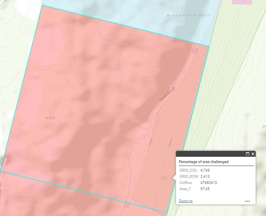
Mobile Wireless Coverage in Vermont

In October and November of 2018 The Department of Public Service (PSD) conducted a drive test of the
state of mobile wireless coverage in Vermont. The initiative was undertaken primarily to demonstrate
that good cause exists to expand the territory in the state that is deemed eligible for forthcoming
federal grants. When the test results were completed and submitted to the Federal Communications
Commission (FCC), the PSD analyzed the results to derive insights about mobile wireless service in the
state. This report describes the drive test process, provides a summary of the results, and explains how
the information was assessed by the FCC for the grant process.

FCC Mobility Phase II program

The FCC, through the Mobility Phase II program, intends to direct up to $4.53 billion in support through
reverse auctions to bidders that commit to offer mobile wireless service in eligible areas throughout the
nation. When the program was announced only a small amount of territory in Vermont was eligible for
this funding. Under the FCC rules for the program, areas without access to wireless service providing 5
Mbps will be eligible for the grants. To identify these areas, the FCC directed service providers to submit
information, on a confidential basis, depicting the area where they believe consumers have access to
service with at least 5 Mbps. The FCC identified the eligible areas as those areas where no company
asserted that it offers service at 5 Mbps or better. This process resulted in only 1,310 square kilometers
of eligible areas in Vermont, out of a total territory of approximately 25,000 square kilometers.
The FCC also authorized a process by which states could challenge asserted wireless coverage in
ineligible areas. After reviewing confidential maps submitted by providers that purport to show the
extent of coverage it was clear that many of the areas purportedly served in fact very likely lacked
service. The PSD undertook a test of all major roads in the state to determine where mobile wireless
service is actually available from a consumer perspective. The data gathered by the Department through
its participation in the challenge could render significantly more territory in Vermont eligible for this
grant process.
Drive Test Methodology

Because the primary purpose for the Department’s drive test effort was to participate in the FCC
challenge process, the PSD developed a methodology to generate data that would meet the rigorous
specifications laid out by the FCC for a challenge. The FCC developed a map that divides each state into
thousands of one-kilometer square blocks. In order to successfully challenge coverage in a block, a
challenger was required to submit results of download speed tests conducted within that block which
demonstrate speeds below 5 Mbps. Separate results had to be submitted for each provider that
allegedly serves that block, within the part of the block they purportedly serve. Moreover, the FCC
specified that to successfully challenge service in a block, a challenge must encompass 75% of the test
area, where each test point was afforded a radius of 400 meters.

Some states prepared challenges by reviewing the confidential maps submitted by the providers and
targeting testing in small areas. Other participants chose to challenge service for only individual
providers in select areas. Analysis of initial proof-of-concept tests showed that a drive test sticking to
main roads would not be very efficient at meeting the FCC requirement to test 75% of the territory of a
block. Meeting the 75% threshold would require several tests at least 400 meters apart within each
block. This could be met if the route went directly through the middle of a block. In most cases
however, the main roads transect the blocks obliquely, that is, along a side or a corner. In these blocks, a
drive test would not meet the 75% requirement. The PSD lacked time or budget to conduct a test
thoroughly enough to meet the 75% threshold on a wide basis. The PSD considered testing only small
targeted areas with a goal of testing on side roads to meet the 75% threshold in those areas. Ultimately,
the PSD decided that the results of a drive test throughout the state could provide insight beyond the
challenge process. Therefore, the PSD determined that it would conduct a drive test of all major roads
(roads that receive federal aid) even though only a portion of the transected blocks would reach the
75% threshold.

The PSD identified an Android smartphone application, G-NetTrack, that recorded the results specified
by the FCC. An initial review demonstrated that while the app recorded results for the three required
parameters (latency, signal level, and download speed) each was recorded with a different timestamp
and location. It would be difficult to put this information in the format required by the FCC for the
submission. PSD staff contacted the app developer who agreed to update the app to include all three
parameters in a data sequence with a single timestamp and location in the results log file. Deployment
of the app required the assistance of the Vermont Agency of Digital Services (ADS). ADS configured an
Internet server to host a file containing thousands of pictures. The app on the smartphones was
configured to attempt to download this file and record the results at set intervals.

The PSD configured the application to conduct a test sequence lasting 20 seconds, consisting of a 10
second download test, 5 second ping test, and a 5 second pause. The PSD acquired handsets and service
for each of the six facilities-based providers that asserted service in the state: AT&T, Sprint, T-Mobile, US
Cellular, Verizon Wireless, and VTel Wireless. The PSD configured the app to continually repeat the test
sequence on each handset while the drive tests were underway. With an average speed of 40 Miles per
hour (18 meters per second), the test every 20 seconds produced data with about 360 meters between
result locations. The product of this effort is a set of 187,506 download speed test results at locations
along all of the major roads in the state.

Statewide Results

The Department employed the one-kilometer square blocks developed by the FCC to generalize the
results. This generalization is helpful for analysis and to view the information in maps at large scales,
such as for a statewide view. For each carrier, the PSD determined the average download speed
recorded in each block using the following five-tier classification system:

    •       No service, text, voice, and data not available

    •       Spotty service, under 256 kbps, text may be possible, voice not likely

    •       OK service, up to 5 Mbps, voice, text and email likely, web browsing may be possible

    •       Good service, 5 Mbps to 10 Mbps, voice, text and web browsing likely, streaming may be

        possible

    •       Great service, more than 10 Mbps, voice, text and video streaming likely

It is important to keep in mind that while this generalization is indicative of the coverage, it is not meant
to assert the availability of such coverage throughout each block. In fact, there can be significant
variation in coverage within any block. Users should refer to the individual download speed tests visible
on the interactive maps for more precise information.
The chart below compares the average download speeds obtained by each carrier in the tests. For each
carrier, the chart lists the percentage of blocks where the average recorded download speed falls into
five different speed tiers.
Average Recorded Download Speeds (Mbps)
100% 1%
3% 4% 3% 6%
13% 15% 8% 7%
90%
25% 31%
12% 7%
80% 35%
11% 31%
70% 33%
14%
60%
18%
39%
50% 8%
51% 27%
21%
22%
40%
30% 5% 10%
44% 42%
20% 29%
30%
11% 24% 22%
10%
10%
4% 4% 4% 6% 4% 4%
0% 0%
Any Verizon AT&T T-Mobile Sprint US Cell VTel
No record 0 >00.2565 >10
Analysis of this data shows these key findings:
• The two largest carriers, AT&T and Verizon, have a similar number of blocks where they have at
least some service: 72% for Verizon and 74% for AT&T;
• 65% of the tested blocks have service from both AT&T and Verizon;
• 54% of the tested blocks are served by both AT&T and Verizon at speeds better than 0.256 kbps;
• 15% of the tested blocks have no service from either AT&T or Verizon;
• Verizon has the largest number of blocks with the highest speeds, 31% for Verizon vs. 13% for
AT&T and 15% for T-Mobile;
• There are 106 blocks served only by VTel Wireless, including 47 where the download speed was
less than 0.256 kbps.Blocks were there is no recorded speed test for that carrier are the result of the nature of the drive test. While the drive test recorded data for all carriers along the same routes, the tests were not exactly synchronized, so not all carriers have results in all blocks. Vermont FCC Challenge Submittal The FCC employed an automated process to review the results of the drive test submitted by the PSD. In order to challenge service in a given one-kilometer block, challengers were required to submit download speed tests within the asserted coverage area in that block for each carrier that asserted coverage. The process identified 4,186 blocks where the challenge was successful. Of these, 789 blocks met the requirement to test 75% of the block. In another 3,397 blocks, the challenge was only provisionally accepted because the tests submitted covered less than 75% of the block. The process rejected the challenge in 1,879 one-kilometer blocks. Of these rejected blocks, 1,607 were apparently rejected because all of the tests for all carriers that asserted service in that block exceeded 5 Mbps. Another 272 blocks had tests that demonstrated less than 5 Mbps, (including 194 blocks showing no service at all) but were rejected because the specific location of the tests fell outside of the company’s asserted coverage area. Many of these rejected blocks are adjacent to the identified Eligible Area. The table below depicts the quantity of blocks and the quantity of E-911 Business and residential buildings within these blocks for different categories of blocks. Category Blocks PCT Buildings PCT Challenge accepted (75% tested) 789 3% 23,087 8% Challenge provisional (
Interactive Map
The Department prepared an interactive map service depicts mobile wireless coverage for each of the
six facilities based providers operating in Vermont: AT&T, Sprint, T-Mobile, US Cellular, Verizon
Wireless, and VTel Wireless. The map is accessible on the Department website.

Use the two buttons in the upper right to navigate the site:

    •          Layer button, to select between providers

    •              Legend button, an explanation of the colors

The layer for each provider includes two maps: a coverage map with information prepared by the
service provider, and the results of a drive test conducted by the Vermont Department of Public
Service in October and November, 2018.

COVERAGE MAP: The coverage maps, shown in pink           , were submitted by the provider to the
Federal Communications Commission and indicate where the provider believes consumers should
expect to receive data service with at least 200 kbps, as of December 31, 2017. This publicly
available information was downloaded from the FCC website; it was produced by the individual
providers and the PSD makes no claim about its accuracy. For VTel Wireless, users may optionally
enable the VTel Wireless ARRA service territory map by clicking Layer button, then the right arrow
next to VTel.

DRIVE TEST MAP: PSD staff employed the android smartphone application G-NetTrack to conduct
download speed tests at approximately 300 meter intervals along all federal-aid highways. The
results of the drive tests are show with five colors, as follows:

    •       No service, text, voice, and data not available

    •       Spotty service, under 256 kbps, text may be possible, voice not likely

    •       OK service, up to 5 Mbps, voice, text and email likely, web browsing may be possible

    •       Good service, 5 Mbps to 10 Mbps, voice, text and web browsing likely, streaming may be

        possible

    •       Great service, more than 10 Mbps, voice, text and video streaming likely

The drive test data is presented in two formats, depending on the scale of the map (how far the user
zooms in or out):
   • DATA TEST POINTS: When zoomed-in to a neighborhood scale, the service depicts the results
        of the 187,000 individual data tests. Clicking on an individual point will provide the
        information from that test, including the timestamp, the download speed (in Mbps), the
        latency (the round-trip time for a request to a website, in milliseconds), and the signal
        strength (RSRP in dBm).
   • AVERAGE SPEED BLOCKS: When zoomed-out beyond the neighborhood scale, the map depicts
        blocks, one kilometer square, that show the average of the download speeds recorded within
        that block. This generalization of information provides users an indication of coverage in a
        neighborhood when viewed at different scales. THIS DOES NOT INDICATE SERVICE
        THROUGHOUT A BLOCK. Users should zoom-in to view the individual download speed test
        points and judge accordingly.

In addition to the data for each individual provider, the Layer button       allows users to select two
additional views:
The COMPOSITE layer depicts the blocks that contain download tests, color coded by the average of all of the tests, for all carriers, conducted in that block. This includes data for all carriers, and thus masks variation in coverage between individual providers. Clicking on an individual block will show the average results for each provider in that block. Results listing "999.000" indicate no test was conducted for that carrier in that block. The CHALLENGE layer depicts the status of each block in the submission of the PSD in the FCC Mobility Fund Phase II Challenge process. Blocks are depicted in one of three colors. Blue blocks are where the challenge was rejected, either because a.) the block is already largely eligible, or b.) because no tests below 5 Mbps were submitted. Blocks that are red and pink were accepted because tests with results less than 5 Mbps for each carrier that asserted coverage were submitted. Blocks in red met the requirement for testing 75% of the block. The challenge for the blocks in pink may be considered but did not meet the 75% territory requirement. This layer also includes the original "eligible area" in purple , areas where no carrier asserted that it provides service.
Difficulty meeting the 75% threshold:

Of the 4,186 tested blocks, 3,397 did not meet the 75% threshold. Here are some examples that
demonstrate the difficulty of meeting this requirement.

For instance, see Grid_Col 4,768 / Grid_Row 2,413. The PSD challenge for this block was accepted and
the challenged area was calculated to be 57.65%. The PSD tests were all along the main road, Route 12.
There are no other roads in this block, and the steep terrain would make additional testing in this cell by
hiking treacherous. Moreover, the buildings in the area would be along the roads, so testing the area of
the block lacking roads is highly inefficient.
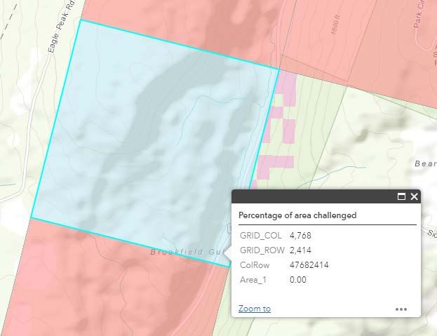
Blocks rejected because the tests were “Outside Challengeable areas of a block”

Of the 1,879 blocks where the tests were deemed invalid, 194 were blocks where the tests demonstrate
no service from any carrier, and 78 show service less than 5 Mbps from any carrier. These were likely
rejected because the tests were not conducted within the “challengeable” area of a block. That is, the
tests need to be conducted not only within the block, but for each carrier, the test must be conducted
within the portion of the block that the carrier claimed it served. This is problematic if the carrier
asserts that it serves a part of a block with no roads.

For example see Grid_Col 4768 / Grid_Row 2414. Most of the cell is allegedly served, and is thus
ineligible, with just a few pixels that lack asserted coverage. By chance the PSD tests in this cell fell
within these few pixels.
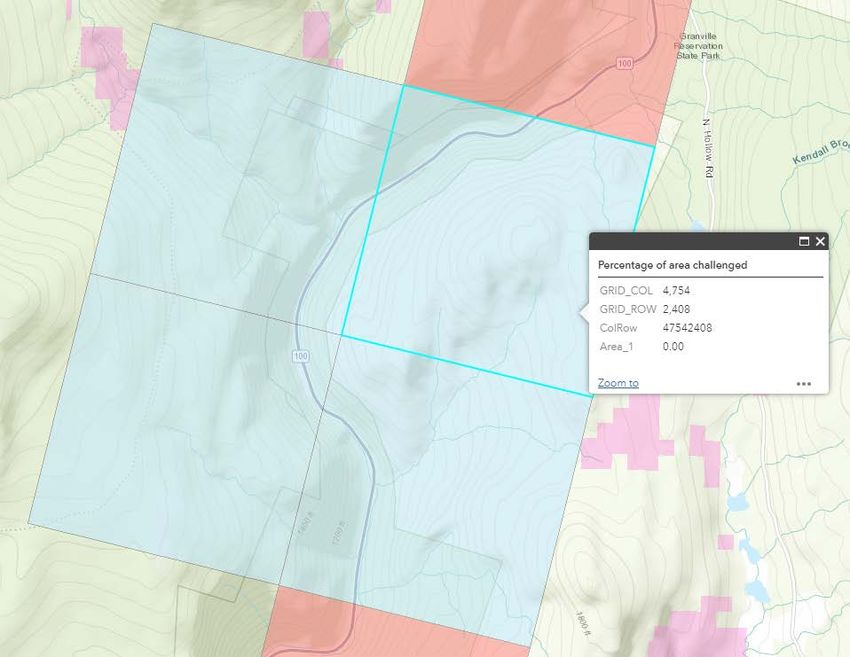
As an another example, see the four blocks around Grid Col 4753, Grid_Row 2408. The tests were all
along the roads in Eligible areas, while the area with asserted coverage lies in the roadless areas on the
hills above.
You can also read