Modelling urban spatial change: a review of international and South African modelling initiatives - GCRO
←
→
Page content transcription
If your browser does not render page correctly, please read the page content below
06
                             Modelling urban
      s i o n a l p a p er

                             spatial change:
                             a review of international
OcC a

                             and South African modelling
                             initiatives

                                        Chris Wray, Josephine Musango
                                        and Kavesha Damon
                                        Gauteng City-Region Observatory

                                        Koech Cheruiyot
                                        NRF: SARChI Chair in Development
                                        Planning and Modelling at Wits

                                        August 2013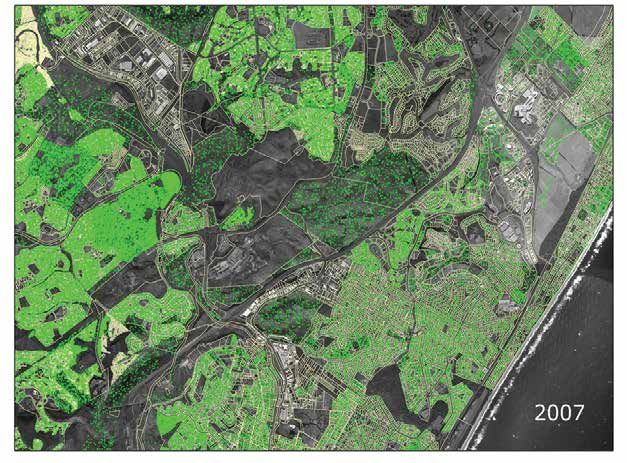
ISBN Number: 978-0-620-58368-8
Modelling urban
      s i o n a l p a p er

                                                     spatial change:
                                                     a review of international
OcC a

                                                     and South African modelling
                                                     initiatives

                                                                                    Chris Wray, Josephine Musango
                                                                                    and Kavesha Damon*
                                                                                    Gauteng City-Region Observatory

                                                                                    Koech Cheruiyot#
                                                                                    NRF: SARChI Chair in Development
                                                                                    Planning and Modelling at Wits

                                                                                    August 2013

*
               Chris Wray is a Senior Systems Analyst at GCRO, Josephine Musango was a Senior Researcher at GCRO and is now based at the University of
               Stellenbosch, Kavesha Damon was a GIS intern at GCRO and is now based at SEFSA.
#
               Koech Cheruiyot was a Postdoc at the National Research Foundation: South African Research Chairs Initiative (NRF: SARChI), Chair in Devel-
               opment Planning and Modelling hosted at the University of the Witwatersrand, Johannesburg (Wits), and is now a Senior Researcher at GCRO.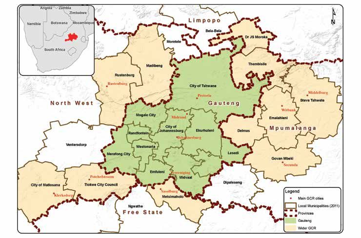
Disclaimer
The views or opinions presented in this document are solely those of the author/s and do not necessarily
represent those of the Gauteng City-Region Observatory or any of its partners.
Executive summary
The purpose of this report is to examine international and South African urban modelling projects that
monitor or simulate urban spatial change. Urban land use modelling involves testing spatial location
theories and interactions between various land uses, actors, and other related activities in urban settings.
As such, urban growth and land use change models have the potential to become important tools for
urban spatial planning and management.

The research addressed the following questions:

•   What aspects or components of urban spatial change are being modelled internationally and within
    South Africa?
•   What urban models were used since 2000 and by whom?
•   What data and software are utilised for the various modelling projects?
•   What modelling methodology, software and visualisation tools might be appropriate for monitoring
    or simulating urban spatial change in the South African context, specifically in the Gauteng City-
    Region (GCR)?
At the international level, the report documents five main urban modelling categories: land use
transportation (LUT), cellular automata, urban system dynamics, agent-based models (ABMs) and
spatial economics/econometric models (SE/EMs). These models can be described as follows:

•   LUT models, developed and improved over the last four decades, view urban structures as reciprocal
    relationships between land use and transport. These models are based on the premise that transport
    planning decisions affect land use development and vice versa. A variety of LUT models are used to
    explain and predict land use and transport relationships.
•   Cellular automata models apply a set of transition rules on a two-dimensional grid of cells where each
    cell represents a land use and the change in land use is based on the state of the neighbouring cells.
    Cellular automata models have been widely applied in modelling land use growth, although in some
    cases is considered too simplistic for modelling complex systems.
•   System dynamics models, introduced in the 1960s, treat urban systems as complex, dynamic, and self-
    organising entities. System dynamics models therefore appreciate the complex interactions that
    exist within urban systems, such as transport networks, housing infrastructure, water and energy
    supply networks and social networks. A specific strength of system dynamics is its representation of
    temporal processes.
•   ABMs and microsimulation, based on individual behaviours of actors in an urban system, emerged in
    the past two decades and have been used, especially by scientists in urban and geospatial studies, as
    effective paradigms for framing the underlying problems of complex and dynamic processes. These
    models are credited for representing individual agents’ actions and behaviour and aggregating them
    in space.
•   SE/EMs focus on demography and household-driven demand-supply relations in urban regions,
    such as housing market developments. SE/EMs rarely consider the environment and feedback loops
    to the original driver.

                                                                                                               i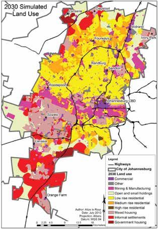
A full list of the above models that were reviewed are summarised in Annexure A. This report reveals
     that instances exist where these models are integrated and overlap, for example, UrbanSim modelling
     software incorporates LUT models and ABMs.

     Within South Africa, the report documents urban spatial change and growth modelling initiatives, a
     number of which do not strictly fall into international categories as noted above. Except for the UrbanSim
     project, with the Gauteng model still being developed, and limited academic research utilising cellular
     automata simulation, the bulk of existing modelling initiatives are primarily geographic information
     systems (GIS)-based and/or linked to spread sheets containing demographic or housing projections.
     Remote sensing research focusing on historical land cover change was also prevalent.

     As such, the South African urban modelling typologies are categorised differently from the international
     typologies and include a broader range of urban modelling techniques. Typologies used are the following:
     provincial government modelling initiatives in Gauteng; municipal government modelling initiatives;
     other government-funded modelling research; and academic modelling research. The various modelling
     initiatives described and summarised in Chapter 4 and Annexure B are by no means a comprehensive
     review of all urban spatial change modelling projects in South Africa, but provide a broad indication of
     the types of urban spatial change modelling underway. Importantly, the models may form the basis for
     more accurate and sophisticated urban modelling projects in the future.

     This report also identifies key urban modelling opportunities and challenges for short- to long-term
     planning in the GCR and South Africa.

     Urban modelling opportunities
     Several short-, medium- and long-term planning initiatives currently underway, such as the provincial
     G2055 project and Joburg Growth and Development Strategy (GDS) 2040, lend themselves to urban
     modelling in the GCR.

     Establishing a growth forecasting and spatial planning unit
     The draft Gauteng Growth Management Strategy proposes a comprehensive growth forecasting
     and spatial modelling exercise for the province as a whole, as well as individual municipalities. The
     establishment of a growth forecasting and spatial modelling unit presents an excellent opportunity to
     embed spatial modelling and coordinated planning in government policy and practice.

     Extending current urban planning models
     There is potential to refine existing models to serve as a starting point for informing long-term planning,
     rather than duplicating efforts. This should include improving the process of developing, extending,
     and applying models and supporting their effective use in long-term projects, such as G2055 and the
     growth development strategies of individual municipalities. In particular, this should entail improving
     data collection and quality, mutual agreements on the use of a common set of population projections, and
     entrenching participatory processes in modelling work. Utilising the Council for Scientific and Industrial
     Research’s (CSIR) UrbanSim project as an integrated modelling platform for the GCR will ensure that the
     significant amount of money, skills and time invested do not go to waste. This is, however, dependent on
     overcoming the current data issues affecting the Gauteng model.

ii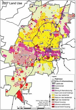
Improving an understanding of the role models play in testing policy scenarios
It is important to emphasise that while models are intended to inform policy, they are not crystal balls
that can magically predict the future. Models should rather be understood as presenting opportunities
for testing the different implications of various policy scenarios. This necessitates a careful selection of the
scenarios to be tested. The involvement of stakeholders during the entire modelling process is therefore
of utmost importance.

The on-going development and availability of cross-sectional, time series and
other data
In line with the GCR’s modelling priorities (see Annexure D), a number of factors, such as the availability
of three sets of Census data (1996, 2001 and 2011) and ‘Quality of Life’ (QoL) Survey data (2009, 2011,
2013) for the first time, provide an opportunity to revise and recalibrate the models with accurate and
up-to-date demographic variables. From such processes, trends analysis and projections are now also
possible.

Development of common modelling platforms
The planned operationalisation of the Gauteng-wide GIS platform, or GeoGCR spatial database by the
Gauteng Planning Commission (GPC), and establishment of a national observatory, proposed by the
National Planning Commission (NPC), represents an opportunity for integrated modelling coordination
and sharing of outputs across different spheres – local, regional and national. Careful consideration
should be given to the possible overlapping roles and work of the national observatory and stepSA
(Spatial Temporal Evidence for Planning South Africa) programme.

Development of modelling skills at tertiary education level
The continued collaboration between tertiary education and research institutions provide fertile ground
for the development of modelling skills in the country. For instance, the proposed development of the
University of the Witwatersrand Institute for Data Science and Policy Studies may provide the skills
and software to assist with the storage and analysis of large datasets feeding into urban models and
development of a new data and modelling skills base.

Development of a range of urban models at different scales and levels of
complexity
The highly technical, data hungry and complex UrbanSim model represents the top-end of urban
simulation. Other urban spatial change modelling approaches identified in Chapter 3, such as cellular
automata, may provide a simpler short-term picture of the future urban form and act as a multi-scaled
approach to modelling and guide to policy. For example, a broad-scale GCR model can be developed,
together with zoomed in development hotspots modelled in more detail. Research projects in this area, in
conjunction with local and provincial government planning departments, should be encouraged.

                                                                                                                   iii
Urban modelling challenges
     There are, however, a number of challenges that threaten the successful development of urban models
     in the GCR.

     Streamlining and coordinating the various modelling efforts currently
     underway in the GCR and South Africa
     There is a degree of duplication within Gauteng where a number of departments/institutions are
     modelling the same output using different base data and population projections. There is, therefore, a
     need to ensure that any models developed within each of the frameworks work together – where possible
     and applicable – off a common base. This is crucial in the development of an integrated modelling
     approach that will benefit the various long-term planning strategies currently under development by the
     three spheres of government. Similar to the stepSA initiative, the joint provincial and municipal urban
     growth forum and growth forecasting and spatial modelling unit proposed by the draft Gauteng Growth
     Management Strategy should work towards achieving coordinated modelling in the GCR.

     A centrally accessible geodatabase for the GCR: GeoGCR
     Provincial spatial data are not easily accessible publicly (or even between departments) and a fundamental
     transformation of the way spatial data are collated and shared at local and provincial level within the GCR
     is required. This can only be achieved through the establishment of a centrally accessible and up-to-date
     geodatabase that can host all the key data layers required by the various modelling projects. Correctly
     implemented, the GeoGCR spatial database, proposed by the Gauteng Provincial Government (GPG),
     will go a long way to ensuring that all departments involved in any kind of modelling are working off
     a common spatial database. The development of the GeoGCR database needs to be fast-tracked by the
     institutions mandated to establish it.

     Modelling the wider GCR as opposed to modelling the Gauteng Province
     The wider GCR extends beyond the Gauteng Province into neighbouring provinces and represents a vast
     functioning region with dynamic relationships. This needs to be considered in any long-term strategic
     plan or model claiming to have a city-region focus. Modelling across such a vast extent raises a range of
     issues, such as data availability and application of an appropriate modelling scale. As highlighted above,
     a multi-scale approach to modelling is required.

     Report structure
     After the introduction in Chapter 1, a definition of modelling and urban spatial change is discussed in
     Chapter 2. Chapter 3 provides a literature review of urban modelling (focusing mainly on international
     examples), summarised according to five categories of models: LUT, cellular automata, urban system
     dynamics, ABM and SE/EMs. Chapter 4 discusses South African urban modelling initiatives. The report
     ends with Chapter 5 that discusses key modelling challenges and possible modelling opportunities that
     may benefit and inform long-range development planning processes in the GCR.

iv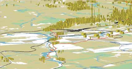
Contents
Executive summary                                                     i
     Urban modelling opportunities                                    ii
     Urban modelling challenges                                       iv
     Report structure                                                 iv
list of figures                                                       2
list of tables                                                        2
List of Acronyms/Abbreviations                                        3
1.	Introduction                                                       5
2.	Understanding urban modelling                                      8
     2.1	Urban modelling concepts                                     8
     2.2 Evolution of urban modelling                                 8
     2.3	Types of urban models                                        10
3.	Literature review of urban spatial change models                   12
     3.1	LUT models                                                   12
     3.2	Cellular automata                                            16
     3.3	System dynamics models                                       18
     3.4	ABMs                                                         19
     3.5	SE/EMs                                                       21
     3.6	Summary                                                      22
4.    SOUTH AFRICAN URBAN GROWTH MODELLING INITIATIVES                23
     4.1	Provincial government modelling initiatives in Gauteng       24
     4.2	Municipal government modelling initiatives                   32
     4.3	Other government-funded modelling research: CSIR UrbanSim    38
     4.4	Academic modelling research                                  42
     4.5	Summary of South African modelling initiatives               49
5.	Conclusion: key challenges and potential modelling opportunities   50
     5.1	Key urban modelling challenges facing the GCR	               51
     5.2	Urban modelling opportunities in the GCR	                    53
References                                                            56
Annexure A                                                            65
Annexure B                                                            74
Annexure C                                                            79
Annexure D                                                            80

                                                                           1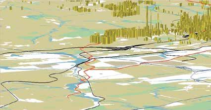
GCRO OcCasional paper 06
List of Figures
Figure 1: The GCR 6
Figure 2: Intersecting time line of urban model development with the growth of
cities and evolving planning approaches 9
Figure 3: Chronological development of land use and transportation models 13
Figure 4: UrbanSim model agents interacting in urban markets 15
Figure 5: The AGENT: agents and constraints 20
Figure 6: The structure of the GSDF according to the proposed web application 31
Figure 7: Soweto BRT and Rail Precinct Development Corridor 37
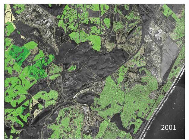
Figure 8: Preliminary results of simulated urban growth in eThekwini
(Umhlanga region) 2001-2007 40
Figure 9: Illustration of the Dyna-Clue model 44
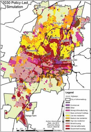
Figure 10: Dyna-Clue modelling in Johannesburg to 2030: (a) initial 2007 land
use; (b) the AS-IS scenario; and (c) policy-led simulation 45
Figure 11: Corridor development at the convergence of road and rail in
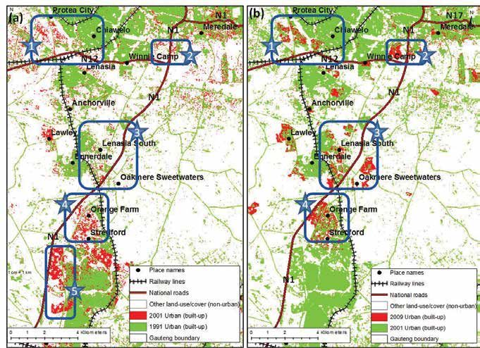
(a) 1991-2001 and (b) 2001-2009 48
Figure 12: The building blocks of the GeoGCR 52
Figure 13: G2055 framework and 14 strategic pathways 54
List of Tables
Table 1: Summary of micro-simulation LUT models 14
Table 2: Agents, choices and models in UrbanSim 16
Table 3: Cellular automata structure and rules 17
Table 4: The “seven sins of large-scale models” and the fundamental changes
required to address these shortcomings 22
Table 5: Summary of population growth scenarios used by various GPG
departments 28
Table 6: The GIS-based models utilised in the GSDF 29
Table 7: UrbanSim data requirements and main data sources 39
2August
Modelling urban spatial change:
a review of international and South African modelling initiatives 2013
List of Acronyms/Abbreviations
ABM Agent-based model
AHP Analytic Hierarchy Process
BAS Building Application System (City of Johannesburg)
BRT Bus Rapid Transit
CIRAD Centre de Coopération Internationale en Recherche Agronomique pour le
Développement
CLUE-S Conversion of Land Use and its Effects at Small regional extent
CoJ City of Johannesburg
CORMAS COmmon-pool Resources and Multi-Agent Simulations
CRUISE Centre for Regional and Urban Innovations and Statistical Exploration
CSIR Council for Scientific and Industrial Research
CSM Cost Surface Model (eThekwini)
DPSIR Driving Forces, Pressure, State, Impact and Response
DRT Department of Roads and Transport (Gauteng)
DST Department of Science and Technology
DYNAMO DYNAmic MOdels
EMME Travel demand modelling software
ETM+ Enhanced Thematic Mapper Plus
G2055 Gauteng 2055 long-term regional plan
GCR Gauteng City-Region
GCRO Gauteng City-Region Observatory
GDP Gross domestic product
GDS Growth and Development Strategy
GIRIP Gauteng Infrastructure Renewal and Investment Plan
GIS Geographic information systems
GITMC Gauteng Integrated Transport Modelling Centre
GMS Growth Management Strategy (City of Johannesburg)
GPC Gauteng Planning Commission
GPG Gauteng Provincial Government
GSDF Gauteng Spatial Development Framework
GSRNR Gauteng Strategic Road Network Review
GTI GeoTerraImage
GTS 2000 Gauteng Transportation Study
GVA Gross value added
HDA Housing Development Agency
HSRC Human Sciences Research Council
IDP Integrated Development Plan
IDPM Integrated Development Planning and Modelling Project
IGU International Geography Union
ILUMASS Integrated Land-Use Modelling and Transport System Simulation
ILUTE Integrated Land Use Transportation Environment
IRPUD Institute of Spatial Planning of the University of Dortmund
ITLUP Integrated Transportation and Land Package
ITMP25 25 Year Integrated Transport Master Plan for Gauteng
LILT Leeds Integrated Land Use model
3GCRO OcCasional paper 06
LUT Land use transportation models
MARS Metropolitan Activity Relocation Simulator
MATSim Multi-Agent Transport Simulation
MCA Multiple-criteria approach
MEC Member of the Executive Council
MSFM Municipal Services Finance Model
MSS Multispectral Scanner System
MSTM Maryland Statewide Transport Model
MUSSA Modelo de Uso de Suelo de Santiago
NGO Non-governmental organisation
NYMTC-LUM New York Metropolitan Transportation Council-Land Use Model
OECD Organisation for Economic Co-operation and Development
PWV Pretoria Witwatersrand Vereeniging
QoL GCRO’s Quality of Life survey
RDP Reconstruction and Development Plan
SDP Spatial Development Plan
SDF Spatial Development Framework
SE/EMs Spatial economics/econometric models
SIC Standard Industrial Classification code
SHSUP Sustainable Human Settlement Urbanisation Plan (City of Johannesburg)
SLEUTH Slope, Land cover, Exclusion, Urbanisation, Transportation and Hillshade
StatsSA Statistics South Africa
stepSA Spatial Temporal Evidence for Planning South Africa
TAS Township Application System (City of Johannesburg)
TELUM Transportation Economic and Land Use Model
TM Thematic Mapper
TLUMIP Transportation and Land Use Integration Project
UCT University of Cape Town
UDL Urban Dynamics Laboratory (CSIR)
UES Urban Expansion Scenario
UGM Urban Growth Model (City of Cape Town)
UGMS Urban Growth Monitoring System (City of Cape Town)
UJ University of Johannesburg
UK United Kingdom
UKZN University of KwaZulu-Natal
UNCHS United Nations Centre for Human Settlements
UP University of Pretoria
USA United States of America
Wits University of the Witwatersrand, Johannesburg
4August
Modelling urban spatial change:
a review of international and South African modelling initiatives 2013
1. Introduction
The United Nations Centre for Human Settlements’ (UNCHS) State of the World Cities Report (2012/2013)
predicts that the world is moving into the urban age, where urban areas worldwide are not only becoming
the dominant form of habitat for humankind, but also the engine-rooms of human development as a
whole (UNCHS, 2012). Rapid urbanisation raises various challenges, including the expansion of slum
settlements, a growing backlog in infrastructure investments, and pressure on available resources such
as water, energy and food. Planners and policy makers need to drive urban development that is socially,
economically and ecologically sustainable in an ever more complex and unpredictable context. It is,
therefore, important to develop tools that urban professionals will use to formulate timely and effective
policies to monitor and guide urban development.
Urban land use modelling involves testing theories regarding spatial location and interactions between
various land uses, actors, and other related activities in urban settings. Due to advances in computer
hardware and software, including geographic information systems (GIS), increased digital data
availability, and human understanding of natural and social system functions, urban modelling has
evolved from simple calculations of the linear relationships between one or two spatial elements to much
more sophisticated simulations of entire urban systems. The more advanced models seek to account
for the dynamic relationships between multiple elements in various sub-systems – spatial, economic,
institutional, ecological, social, and so on. Urban growth and land use change models have the potential to
become important tools for urban spatial planning and management (Herold et al., 2005). The application
and performance of the models is dependent both on the quality and scope of data available and an
understanding of the processes represented in the model (Batty and Howes, 2001).
Across the world, urban observatories have been established as part of the United Nations Global
Network of Urban Observatories to gather accurate urban-level data and monitor trends within a
specific geographical region (Palmer Development Group, 2007). In South Africa, the Gauteng Provincial
Government (GPG) established the Gauteng City-Region Observatory (GCRO) in 2008, as an institutional
partnership between the University of Johannesburg (UJ), University of the Witwatersrand, Johannesburg
(Wits), and the GPG, with local government also represented on the GCRO Board. One of GCRO’s key
tasks is to map and analyse urban spatial change in order to determine possible future trends relating to the
urban form. The GCRO focuses on the Gauteng City-Region (GCR), an integrated cluster of cities, towns
and urban nodes that together form the economic heartland of South Africa (Figure 1). The core of the
GCR is the Gauteng Province, anchored by the three large metropolitan municipalities of Johannesburg,
Tshwane and Ekurhuleni. Gauteng, according to the latest Census1, is the smallest province in South
Africa (18,179 km2), but contains 24% of South Africa’s population with the highest population density
of 675 people per km2. Gauteng’s 2011 population of 12.3 million, which represents a 31% population
increase over the past decade, is expected to double by 2055. The GCR’s economic footprint extends
beyond the borders of Gauteng into the neighbouring provinces of Free State, Mpumalanga and North
West, constituting the wider GCR.
1
See page 2 of the link: http://www.statssa.gov.za/Census2011/Products/Provinces%20at%20a%20glance%2016%20Nov%20
2012%20corrected.pdf
5GCRO OcCasional paper 06
The region is the largest urban economy in South Africa and Africa as a whole – the Gauteng Province
alone contributes 34% of national gross value added (GVA), while the wider GCR accounts for 42%
(GCRO, 2011). The region is also home to O.R. Tambo International Airport, the largest international
airport in Africa and air transport hub of Southern Africa, serving more than 17 million passengers each
year (Airports Company South Africa, 2013). Gauteng has experienced dramatic growth over the past
two decades with the percentage of urban land cover in the province increasing from 12.6% in 1991
to 18.35% in 2009 (Mubiwa and Annegarn, 2013). It is recognised that expanding urban areas tend to
appropriate a disproportionate share of resource inputs and waste sinks, even though urban areas only
account for a small percentage of land surface (Schneider, 2006). This is a potential challenge that the
GCR is faced with as economic growth and urbanisation can lead to adverse environmental impacts in
peri-urban areas due to the rapid increase in urban land use. It therefore becomes crucial to understand
the changing patterns and driving forces of urban development, given the rapid growth in urbanisation.
Figure 1: The GCR
Source: GCRO
Within the GCR, the Gauteng Planning Commission (GPC) is tasked with long-term integrated city-region
planning and the monitoring and evaluation of the provincial government’s performance. The GPC’s
flagship project is the Gauteng 2055 (or G2055) project – a long-term plan that sets out to “maximise the
city-region’s potential and its value as a key economic driver for the country, through careful long-term
planning aligned with the national vision and other strategic perspectives” (GPC, 2012:2). The G2055
plan is currently being drafted and is underpinned by four strategic pillars: equitable growth, social
6August
Modelling urban spatial change:
a review of international and South African modelling initiatives 2013
inclusivity and cohesion, good governance, and sustainable growth and infrastructure. Such long-range
development planning processes call for the need to understand more accurately the long-term prospects
for urban change and the likely impact of different planning and infrastructure choices and investments
on the future urban form.
GCRO is assisting with components of research for G2055 and has a number of projects investigating
spatial change in the GCR. From its inception in 2008, GCRO has invested a significant amount of time
and resources into collating a diverse spatial database which could constitute an input into a modelling
exercise, but has yet to undertake any form of urban simulation. Before embarking on any modelling,
GCRO felt it was important to take note of, and critically assess lessons to be learnt from international
experience and scholarship on spatial modelling, as well as a number of South African experiments
that model future urban development. In 2012, GCRO initiated preliminary research into current
international and South African modelling trends through a desktop study and telephone, email and
personal interviews.
This report sets out to investigate the following question: What urban spatial change modelling research
is currently being undertaken internationally and within South Africa? To answer this, the research
explored:
• What aspects or components of urban spatial change are being modelled?
• What urban models were used?
• What data and software are utilised for the various modelling projects?
• What modelling methodology, software and visualisation tools might be appropriate for a GCRO
urban change modelling project?
• What modelling would benefit and inform long-term planning in the GCR?
A mixed approach was utilised to gather information. This included: a literature review of urban spatial
change modelling and simulation from an international perspective; interviews with experts in specific
South African institutions who are busy with projects relating to urban spatial change modelling; and a
workshop held in partnership with the GPC.
The report is structured as follows: firstly a definition of modelling and urban spatial change is discussed
in Chapter 2. Chapter 3 provides a literature review of urban modelling (focusing mainly on international
examples), summarised according to five categories of models: land use transportation (LUT), cellular
automata, system dynamics, agent-based models (ABMs) and micro-simulation modelling, and spatial
economics/econometric models (SE/EMs). Chapter 4 discusses South African urban modelling initiatives.
The report ends with Chapter 5 that discusses key modelling challenges and possible modelling
opportunities that may benefit and inform long-range development planning processes in the GCR.
7GCRO OcCasional paper 06
2. Understanding urban modelling
“Urban models: Representations of functions and processes which generate urban spatial structure
in terms of land use, population, employment, and transportation, usually embodied in computer
programs that enable location theories to be tested against data and predictions of future locational
patterns to be generated.” Batty (2009:51)
2.1 Urban modelling concepts
Before discussing urban modelling in greater detail it is important to understand a few basic concepts
such as ‘urban’, ‘model’, ‘tool’ and ‘modelling’.
There is no generally accepted or standard definition for the term urban. The available definitions often
vary according to the standards of a country’s national statistical agency (Grekousis et al., 2013). In South
Africa, for example, Statistics South Africa (StatsSA) categorises Enumerator Areas for the Census into
one of four types: urban formal, urban informal, rural formal and tribal areas (StatsSA, 2001).
The existing literature indicates that various features have been utilised to characterise urban areas, such
as: (i) population size; (ii) space (land area); (iii) the ratio of population to space (density); and (iv) economic
and social organisation (Weeks, 2010). Without going into detail on the debates around the definition
of ‘urban’, this study adopts Weeks’ definition of an urban area as “a place-based characteristic that
incorporates elements of population, density, social and economic organisation, and the transformation
of the natural environment into a built environment” (Weeks, 2010:34).
A model is generally considered to be a simple representation of reality (Giere, 2004) and theoretical
abstraction that represent systems in such a way that essential features crucial to the theory and its
application are identified and highlighted (Batty, 2009). Models can take on different forms, such as
maps or mental models. Various ‘tools’ in the form of computer programmes or software are utilised
to produce models. Useful computer programmes or software include Excel spread sheets, GIS and
simulation software. The process of using tools, given an appropriate theoretical foundation, to simulate
urban spatial change or growth is referred to as urban modelling.
2.2 Evolution of urban modelling
According to Batty (2008), there are three essential issues that have guided the development of urban
models: the need for better policy and planning in cities; the availability of data resulting in compromises
being made between different model structures; and ad hoc theoretical development resulting in a diverse
field dominated by differing approaches, paradigms and perspectives on what should be modelled.
The way in which urban models and modelling has evolved with respect to the growth and changes in
cities, as well as the need for planning, is illustrated in Figure 2. This section, drawing largely from Batty
(2008), underscores that our knowledge of cities has mainly been from the perspective of 19th century
industrial city growth where cities were seen as stable structures with dominant functions occurring in
the central business district. According to Batty (2008), the growth and development of cities, supported
by the development of transportation technologies, occurred around the periphery and a monocentric
pattern observed in ancient and medieval cities was reinforced. As can be observed in Figure 2, some
8August
Modelling urban spatial change:
a review of international and South African modelling initiatives 2013
cities over time fused together, forming polycentric clusters, conurbations or ‘megalopolis’. Batty (2008)
adds that urban planning was institutionalised in the 19th century in order to deal with urban problems
arising from industrial and population growth. Location control zoning, a top-down planning approach,
was used as one of the main instruments to deal with these emerging problems. Later in the 1960s, much
of the planning became explicitly transport focussed. However, the ideas behind city planning took a
radical shift towards the end of 20th century when the interventions used to deal with the problems were
not yielding results. Planning for the city was then seen as requiring a participatory approach, since cities
were now regarded as volatile and less stable. The theories and models that were used to inform future
planning of the cities were initially closely tied to the top-down and equilibrium dominated approaches.
These included models based on economic-locational theory, social physics2 and spatial/geographical
morphology. Over the years, these ad hoc and static approaches for sketching future cities took a radical
shift to decentralised bottom-up thinking. This radical shift was due to new perspectives on cities, new
planning approaches and the advancement in computational capability that accounted for the complexity
of cities (Batty, 2008).
For this research, the focus was limited to reviewing models that relate to urban spatial and land use
growth and change.
Figure 2: Intersecting time line of urban model development with the growth of cities and evolving planning
approaches
models
Location Regional Macrostatic Aggregate cells
Theory CPT Science models dynamics agents
1933 1955 60-70s 70-80s 1995+
Cities
Chicago Urban Edge cities
Monocentric
School Markets polynucleated
forms
1920s 1960s 1970s+
Planning
Top-down Bottom-up
Controlled Participatory decentralised
centralised 1970s on individualistic
1920s on 1990s+
19th century industrial city..................................................................................21st century global city
Source: Batty (2008:6)
2
According to Batty (2009:51) this is the “application of ideas from classical ‘Newtonian’ physics to social systems usually in
the form of analogies with Newton’s laws of motion as reflected in the concepts of potential energy and gravitational force.”
9GCRO OcCasional paper 06
2.3 Types of urban models
Urban models are mainly computer-based simulations that are utilised to test theories regarding spatial
location and interaction between land uses and other related activities (Batty, 2009). It is acknowledged
that the model types listed here are not all encompassing, since new models are developed regularly.
Therefore, the list only offers the broad category of urban models that are currently used.
2.3.1 Land Use Transportation (LUT) models
These entail aggregate static models of economic and spatial interactions where the urban system is
considered as “a static entity whose land uses and activities were to be simulated at a cross section in
time and whose dynamics were largely regarded as self-equilibrating” (Batty, 2009:53). Their theoretical
foundations are mainly in regional economics, location theory and new urban economics. LUT models
currently incorporate transportation modelling processes of trip generation, distribution, modal split
and assignment explicitly and are consistent with discrete choice methods3 based on utility maximising,
specifically in their simulation of trip-making (Akiva and Lerman, 1985). More recently, a new generation
of micro-simulation models that attempt to account for the behaviour and interactions of individual
agents in space and time have been developed (Iacono et al., 2008). A few examples of newer LUT models
include: UrbanSim (Waddell, 2002), Integrated Land Use Transportation Environment (ILUTE) (Salvani
and Miller, 2005) and Integrated Land-Use Modelling and Transport System Simulation (ILUMASS)
(Moeckel et al., 2003; Strauch et al., 2003).
2.3.2 System dynamics models
These are dynamic, temporal urban models that have been empirically applied (Batty, 2009). Early attempts
at this modelling were observed in Forrester (1969), whose focus was on the development of non-linear
growth and change theory that results in discontinuities coupled with non-linearities, threshold effects or
random perturbations (Batty, 2009). System dynamics models treat urban systems as complex, dynamic,
and self-organising entities. System dynamics therefore models the complex interactions that exist within
urban systems, such as transport networks, housing infrastructure, water and energy supply networks
and social networks. The main strength of system dynamics models is the representation of temporal
processes.
2.3.3 Cellular automata models
Cellular automata models are based on a two-dimensional grid of cells derived from remote sensing
images. Each cell represents a land use and a set of transition rules determine its future state based on
the values of the neighbouring cells. The utilisation of cellular automata in urban modelling has become
a preferred technique since the pioneering work of Tobler (1970), followed by Couclelis (1985), who
identified the potential of cellular automata in modelling urban dynamics. Many efforts have been made
in cellular automata to study land use changes (Li and Yeh, 2002; Almeida et al., 2008), future scenarios
of urban landscape (Barredo et al., 2003; Han et al., 2009), urban growth and sprawl (Batty, 1997; Batty et
al., 1999; Al-kheder et al., 2008) and urban ecological security (Gong et al., 2009).
3
“A development of computable microeconomic theory in which individuals maximize a utility, subject to constraints on their
choices which can be tailored to reflect how decisions are made in complicated situations.” (Batty, 2009:51)
10August
Modelling urban spatial change:
a review of international and South African modelling initiatives 2013
2.3.4 Agent-based models (ABMs) and microsimulation
ABMs is an emerging modelling approach that has in the past two decades been increasingly adapted
by social scientists, especially scientists in urban and geospatial studies, as an effective paradigm for
framing the underlying problems of complex and dynamic processes (Chen, 2012). The greatest attention
this modelling approach has attracted is the ability to represent the actions and behaviour of individual
agents located in space (Batty, 2009). Several examples of ABMs include UrbanSim and TRANSIMS.
A parallel, but significant approach to individualistic modelling is based on microsimulation which
essentially samples individual behaviour from more aggregate distributions and constructs synthetic
ABMs linked to spatial location (Clarke, 1996).
2.3.5 Spatial economics/econometric models (SE/EMs)
SE/EMs are set up as formalised relationships between the population, and related housing market and
residential land use (Haase and Schwarz, 2009). These models can be dynamic (when model parameters
are treated endogenously) or quasi-dynamic (if model parameters are fixed or exogenous during the
modelling exercise). Drivers of change emanate as demand(s) from the population. SE/EMs rarely
incorporate feedback loops back to the original driver.
A more detailed description and examples of these models will be reviewed in the next chapter.
11GCRO OcCasional paper 06
3. Literature review of urban
spatial change models
A systematic literature search of peer-reviewed journals and research reports was conducted to provide a
broad description of urban spatial change modelling projects and identify the latest international trends.
The literature search revealed five main urban modelling categories: LUT, cellular automata, system
dynamics, ABMs and SE/EMs. A few of the studies integrated different types of models and there may
be some overlaps – for example, LUT and ABMs (such as UrbanSim). Each of the five categories of urban
models will now be discussed in brief, with relevant studies summarised in Annexure A.
3.1 LUT models
LUT models have been developed on the premise that urban structures can be understood on the basis
of a reciprocal relationship between land use and transport (Chang, 2006; Iacono et al., 2008). That is,
transport planning decisions affect land use development and land use conditions affect transport activity
(Litman, 2012). For example, a new transport network link may result in an increased investment in land
and subsequent land use changes; or if a land use is rezoned this in turn may influence demand for travel.
Urban researchers have for the past four decades attempted to formalise models that help to explain and
predict these land use and transport relationships (Iacono et al., 2008).
A variety of large-scale LUT models have been developed to assess the possible impacts of urban
development and land use change on transportation patterns. Figure 3 reflects on the development of
LUT models over the past four decades. The majority of LUT models are based on spatial interaction and
econometric models (Iacono et al., 2008; Batty, 2009). The Model of Metropolis was widely considered
to be the first operational spatial interaction simulation model of land use, developed by Lowry in 1964
(Borning et al., 2008; Iacono et al., 2008). The model was based on the Lowry gravity model, “which
adapted the law of gravity from physics and applied it to predict the flow of travel between locations
as a function of the sizes of origin and destination and the ease of travel between them” (Borning et al.,
2008:8). Other examples include: ITLUP (Integrated Transportation and Land Package) (Putman, 1976),
LILT (Leeds Integrated Land Use model) (Mackett, 1983) and the Institute of Spatial Planning of the
University of Dortmund (IRPUD) model (Wegener, 2011).
12August
Modelling urban spatial change:
a review of international and South African modelling initiatives 2013
Figure 3: Chronological development of land use and transportation models
Time
1960 Land use and transportation models
spatial
interaction /
gravity-based
models
1980
Econometric
models
Cell-
Micro- Agent-
based
2000 simulation based
Models
n models
Models
present
Source: Iacono et al. (2008:325)
Lee’s critique of the first generation of large scale urban models concluded that they were too expensive,
complicated and technical, exceedingly aggregated and required huge amounts of data (Lee, 1973).
Aggregate spatial interaction models were also criticised for the use of inappropriate theory to describe
the behaviour captured in the model. As a result a new generation of models based on the study of
disaggregate behaviour using random utility theory to describe choices among discrete alternatives (such
as travel mode) were developed (Iacono et al., 2008). These models apply an econometric or spatial input-
output modelling approach derived from the United States of America (USA) economy monetary flow
models from the 1970s (Borning et al., 2008) and consist of two types. First are regional economic models,
such as MEPLAN and TRANUS. Hunt et al. (2005:332), describes MEPLAN, developed in the United
Kingdom (UK) by a private consulting firm called Marcial Echenique and Partners Ltd, as “an aggregate
model: space is divided into zones, quantities of households and economic activities (called ‘factors’ or
‘sectors’) are allocated to these zones, and flows of interactions among these factors in different zones
give rise to flows of transport demand”. TRANUS also employs a spatial input-output model but is
differentiated from MEPLAN through the application of a more restricted set of functional forms and
modelling options within its framework (Hunt et al., 2005).
The second type of econometric models are land market models. These models have developed an
improved land market representation within the econometric approaches to land use transportation
models, with residential and commercial real estate markets now at the core of the analysis (Iacono
et al., 2008). Examples include: MUSSA (Modelo de Uso de Suelo de Santiago), a model of urban land
13GCRO OcCasional paper 06
and floor space markets developed in Chile that provides equilibrated forecasts of land use and travel
demand used to study various transportation and/or land use policies; and NYMTC-LUM (New York
Metropolitan Transportation Council-Land Use Model), developed for the New York Transit Commission
which models the interactions between residential housing, commercial floor space, labour and non-
work travel markets (Hunt et al., 2005). A recent application of econometric modelling is the Maryland
Statewide Transport model (MSTM) applied in Washington DC (Mishra et al., 2011) to analyse traffic
congestion levels and shifts in travel patterns as a result of land use changes.
According to Iacono et al. (2008), the majority of spatial interaction and econometric models employ a
top-down approach with a set of aggregate relationships between land use and transport based on the
behaviour of a representative individual (usually from a mean calculated from a representative sample),
whereas micro-simulation models disaggregate population and simulate changes from the bottom-up
using small units of analysis such as grid cells or parcels. Table 1 summarises the new generation of
micro-simulation models such as ILUTE, ILUMASS, RAMBLAS (Regional plAnning Model Based on
the microsimuLation of daily Activity patternS) and UrbanSim that attempt to account for the behaviour
and interactions of individual agents in space and time. The UrbanSim model developed by Waddell
(Waddell, 2002) is regarded as the most highly developed of the LUT models (Batty, 2009). Recent surveys
have indicated that UrbanSim is the most widely used land use modelling system in the USA (Waddell,
2011a) and will form the main focus of the remainder of this section.
Table 1: Summary of micro-simulation LUT models
Model Description Reference
ILUTE Comprehensive urban system micro-simulation model; Salvani and Miller (2005)
structured to accurately capture temporal elements in urban
change; activity-travel model include household member
interactions; disequilibrium modelling framework.
ILUMASS Descendent of IRPUD model; incorporates microscopic Moeckel et al. (2003); Strauch
dynamic simulation model of traffic flows and goods et al. (2003)
movement model; designed with environmental sub-model.
RAMBLAS Entirely rule-based model framework; designed to simulate Veldhuisen et al. (2000)
very large populations.
UrbanSim Land use model incorporating microsimulations of Waddell et al. (2003)
demographic processes; land use development; parcel-
level land use representation; high level of household
type disaggregation; open-source software developed for
general use
Source: Iacono et al. (2008:333)
In the 1980s, Paul Waddell recognised the ineffectiveness of metropolitan planning models due to a lack
of behavioural realism, insufficient theoretical underpinnings, insensitivity to important public policies,
and a lack of credibility with both technical planners and policy makers (Borning et al., 2008). UrbanSim
was therefore developed in the late 1990s as a response to (i) the shortcomings of existing metropolitan
planning models; and (ii) new federal legislation and state growth management programmes that required
improved and better integrated models to link land use, transportation and environmental planning
(Waddell, 2002). UrbanSim simulates the key decisions and choices impacting urban development such
as mobility and location choices of households and businesses, and development choices of developers
(Center for Urban Simulation and Policy Analysis, 2008). A micro-simulation strategy is adopted whereby
14August
Modelling urban spatial change:
a review of international and South African modelling initiatives 2013
agents and the choices they make are directly represented in a behaviourally natural and intuitive manner
and can be readily understood, at a basic level, by non-technical stakeholders, such as the general public
(Waddell, 2011b).
UrbanSim has an emphasis on behavioural theory and transparency which leads to a more explicit
treatment of individual agents such as households, jobs, and locations, and to a microsimulation of the
choices that these agents make over time (Borning et al., 2008). Figure 4 illustrates the interaction of these
agents in the urban property market; with the choices and model components of households, businesses,
developers (including government) and the real estate market reflected in Table 2. Developers utilise land
to provide housing for households and floor space for businesses, with households in turn providing
labour for the businesses. Governments provide infrastructure, land and services, and in some cases
regulate or alter the pricing of land and infrastructure provision. Governments, therefore, need to plan for
an increase in households or change in households and set policies or make investment and development
decisions. UrbanSim attempts to draw relationships between these dynamic process by developing a
range of models that show how demographic transitions interact with household location choices, which
in turn impact on real estate prices and business location choices.
Figure 4: UrbanSim model agents interacting in urban markets
Services Governments Infrastructure
land
Housing Developers Floorspace
Households Labor businesses
Flow of consumption from supplier to consumer
Regulation or pricing
Source: Waddell (2011a:10)
UrbanSim can be considered as a family of models which applies a series of approaches and techniques
such as aggregate non-spatial modelling for the economic and demographic transition models and agent-
based discrete choice simulations for the household location choice component (Waddell, 2002). A number
of exogenous variables, such as travel times, are also required. These enter the model exogenously via
external travel/accessibility models, for example, travel demand modelling software (EMME2) or Multi-
Agent Transport Simulation (MATSim).
15GCRO OcCasional paper 06
Table 2: Agents, choices and models in UrbanSim
Agent Choice Model
Household In- and out-migration Demographic transition model
Household Residential moves Household relocation model
Household Residential location Household location choice model
Person Work at home Work at home model
Person Job choice Workplace choice model
Business Birth and death Economic transition model
Business Business relocation Business relocation model
Business Business location Business location choice model
Developer Parcel development Real estate development model
Market Real estate prices Real estate price model
Source: Waddell (2011b:218)
UrbanSim software was developed as an open source project to allow free access to the source code,
encourage collaboration, improve the openness and transparency of the model system, and increase the
robustness of the software and models (Waddell et al., 2003). Originally released to run at a grid-cell level,
UrbanSim now offers parcel or zone-based geometry versions4.
The application of UrbanSim to provide policy analysis of metropolitan growth scenarios was first applied
in the State of Oregon’s Transportation and Land Use Integration Project (TLUMIP) in the USA, as “an
ambitious effort to develop new integrated models to evaluate the interactions between transportation
and land use” (Waddell, 2002). The simulation was tested from 1980 to 1994, with the model validated
against observed 1994 data. Although the results correlated well to the observed data over the period of
15 years, the model did not predict isolated events (such as the opening of a new shopping mall), but nor
was it designed to – an important reminder of the limits of modelling (Waddell, 2002).
UrbanSim has been applied to a number of cities across the USA, including Detroit, Honolulu, Houston,
Phoenix, Salt Lake City, San Francisco, and Seattle. Outside the USA, UrbanSim has been utilised in Accra,
Amsterdam, Beijing, Brussels, Paris, Rome, Seoul, Taipei, Tel Aviv, Turin and Zurich (Waddell, 2011a).
The application of UrbanSim within South African cities by the Council for Scientific and Industrial
Research (CSIR) will be discussed in detail in Chapter 4.
3.2 Cellular automata
The cellular automata modelling approach was invented in the late 1940s by two mathematicians, John
von Neumann and Stanislaw Ulam, who were working at the Los Alamos National Laboratory in the USA
(Barboux and Collet, 2012). Although the term cellular automata has had many interpretations by various
authors, most describe it as a simulation represented by a grid of cells (similar to a remote sensing data
format), based on a set of transition rules that determine the attribute of each cell in its locality (Almeida
et al., 2008). Cellular automata therefore consists of a lattice of discrete cells whose values change on
4
The current release of the software, version 4.4, is available for download from the UrbanSim website, www.urbansim.org.
16August
Modelling urban spatial change:
a review of international and South African modelling initiatives 2013
discrete time steps according to rules that also consider neighbouring effects. For example, the ability of
cellular automata to simulate urban growth is based on the theory that past urban development affects
the future urban form through local interactions between land uses (Sante et al., 2010). According to
Esbah et al. (2011), one of the more commonly used stochastic models is the cellular automata Markov
chain5, which due to its flexible and practical characteristics, has been applied to numerous urban areas
to forecast future urban development, such as Atlanta (Yang and Lo, 2003), Lisbon and Porto (Silva and
Clarke, 2002), Desokata (Sui and Zeng, 2001) and Dongguan in China (Li and Yeh, 2000). Table 3 describes
the main cellular automata elements.
Table 3: Cellular automata structure and rules
Cell space A cell, which can be any geometric shape.
Cell state Represents any spatial variable. For greater flexibility, two groups of cell states are
integrated: fixed and functional.
Time steps The cellular automata model evolves at a sequence of discrete time steps.
Transition rules A transition rule specifies the state of a cell before and after updating based
on its neighbours’ conditions. In the classic cellular automata, transition rules
are deterministic and unchanged during transition. More recently, the rules are
modified into stochastic expressions and fuzzy logic controlled methods.
Spatial neighbourhood A neighbourhood, or area surrounding the cell, defined as either a limited
neighbourhood (Von Neumann) including four adjacent cells or an extended
neighbourhood 14 (Moore) including the eight adjacent cells.
Source: Adapted from Barboux and Collet (2012:12)
The advantages of cellular automata are numerous, namely: flexibility in formulating and generating
complex behaviours from simple rules (Lathi, 2008) and an ability to show spatio-temporal dynamics
(Sietchiping, 2004). Nonetheless, cellular automata’s simplicity relative to other models (such as ABM)
is at the same time a desirable attribute and a significant limitation; and in most cases is inappropriate
for modelling complex systems (Iacono et al., 2008). Sietchiping (2004) adds that cellular automata is
restricted to general rules and cannot create its own dynamics. Therefore, according to Sietchiping (2004),
cellular automata is considered a bottom-up approach that cannot handle human or socio-economic
factors. However, the combination of cellular automata models with the visualisation capabilities of GIS
and remote sensing data makes cellular automata particularly suitable for land use modelling (Torrens
and O’Sullivan, 2001).
An illustration of cellular automata applications include modelling land use policy in Wuhan China up
to the year 2020 (Shi et al., 2012), modelling urban growth at township level in the USA (Al-kheder et al.,
2006), modelling the spread of informal settlements in Cameroon (Sietchiping, 2004), simulating compact
development in China (Li et al., 2008), and simulating urban growth in California (Teitz et al., 2005),
Australia (Liu and Phinn, 2003), Turkey (Demriel and Cetin, 2010), Dublin (Barredo et al., 2003), Gorgan
City, Iran (Mahiny and Gholamalifard, 2007) and Brazil (Almeida, et al., 2008). In South Africa, Le Roux
(2012) has applied the Dyna-Clue cellular automata model to perform urban simulation in Johannesburg
to the year 2030.
5
According to Norris (1998), a Markov chain is a mathematical process that undergoes transitions from one state to another
assuming only a finite set or countable set of states, retaining no memory of its past. This means that only the current state
can influence its transition and the lack of memory property permits the prediction of how a Markov chain may behave.
17You can also read