Nambucca Coastline and Estuaries Coastal Management Program - Item 9.5 Draft Coastal ...
←
→
Page content transcription
If your browser does not render page correctly, please read the page content below
Nambucca Coastline and Estuaries
Coastal Management Program

Draft Report
Nambucca Coastline and Estuaries Coastal Management Program

Nambucca Valley Council has prepared this document with financial assistance from the NSW Government
through the Department of Planning, Industry and Environment (DPIE). This document does not necessarily
represent the opinions of the NSW Government or DPIE.

This report has been prepared by Hydrosphere Consulting on behalf of and for the exclusive use of
Nambucca Valley Council and is subject to and issued in accordance with the agreement between
Nambucca Valley Council and Hydrosphere Consulting. Hydrosphere Consulting accepts no liability or
responsibility whatsoever for it in respect of any use of or reliance upon this report by any third party.

Copying this report without the permission of Nambucca Valley Council or Hydrosphere Consulting is not
permitted.

Cover photo: Clockwise from top: View from Nambucca Lookout (NVC, 2020); Coastal viewing platform;
Kayaks on the Nambucca River at Macksville (Seen Australia in NVC 2020).

Hydrosphere Consulting Pty Ltd
Suite 6, 26-54 River Street
PO Box 7059, BALLINA NSW 2478
www.hydrosphere.com.au

© Copyright 2020 Hydrosphere Consulting

18-019 NAMBUCCA COASTLINE AND ESTUARIES COASTAL MANAGEMENT PROGRAM
 REV    DESCRIPTION               AUTHORS                REVIEW                    APPROVAL        DATE

 0      Draft for Client Review   K. Menzies, K. Pratt   R. Campbell, M. Howland   M. Howland      7 Dec 2020
Nambucca Coastline and Estuaries Coastal Management Program

ACKNOWLEDGEMENT TO COUNTRY

                      Council is proud to acknowledge and
                     respect the Gumbaynggirr people as the
                     Traditional Custodians of the Nambucca
                     Valley and to pay respect to the elders
                             both past and present.

Plate 1: Nambucca Valley Council Acknowledgement to Country
Source: NVC (2020)

                                                                                           Page I
Nambucca Coastline and Estuaries Coastal Management Program

EXECUTIVE SUMMARY
The Nambucca coastline and estuaries study area comprises the entire Nambucca Valley Local Government
Area (LGA) coastline stretching 25 km from North Valla Beach southwards to Scotts Head and including the
Nambucca River estuary, Deep Creek, Swimming Creek and Oyster Creek. The area encompasses a broad
range of natural features including sandy beaches, coastal dunes, rocky headlands, marine areas, estuary
entrances, littoral rainforest, wetlands/heathlands and estuarine environments. It is known as a pristine
coastal location and both locals and visitors place a high value on the abundance of natural resources,
uncrowded areas for nature-based recreation and stunning scenic amenity.

The Nambucca coastline is the traditional land of the Gumbaynggirr people. The estuaries, beaches and
headlands are of great significance to the local Aboriginal people who are committed to the sustainable
management of these areas.

The area remains relatively undeveloped with small coastal towns and villages home to a small local
population including Nambucca Heads, Macksville, Scotts Head and Valla Beach. The core community and
environmental values of the study area are associated with its landscape amenity (i.e. geographical features,
scenic amenity, views), healthy and diverse natural environments and biodiversity values. The Nambucca
Valley LGA is home to a variety of businesses and industries including tourism, oyster aquaculture,
commercial fishing, agriculture (e.g. dairying, grazing, horticulture, tree crops), construction, manufacturing,
timber processing and aged care and health services. The population increases significantly during holiday
periods and the area is facing increasing pressures due to population growth and tourism.

Nambucca Valley Council (NVC) has prepared the Nambucca Coastline and Estuaries Coastal Management
Program (CMP) to set the long-term strategy for coordinated management of the coastline and estuaries of
the Nambucca Valley LGA. This CMP aims to ensure that the values and benefits of the study area are
enhanced and maintained for future generations. NVC will lead the implementation of the CMP for the
Nambucca coastline and estuaries and will collaborate with land managers, state government agencies,
industry and community representatives to provide effective coastal management outcomes.

The long-term vision for the Nambucca coastline and estuaries is:

“The coastline and estuaries of the Nambucca Valley LGA are healthy, adaptable natural
environments supporting abundant wildlife, diverse habitats, a sustainable local economy and
significant cultural values. They are safe, peaceful and accessible places for our community and
future generations to learn, enjoy and prosper.”

The coastline and estuaries are facing numerous threats and pressures that affect the community and
environmental values. Over time, many of these pressures are likely to increase due to increasing
population, potential land use changes, development within the catchments and the impacts of climate
change. Threats were prioritised to assist in identifying the management actions for the CMP. High priority
threats were identified as those presenting a high present-day risk to values and uses of the Nambucca
coastline and estuaries (Table 1). A summary discussion of key threats provided below.

Table 1: High priority threats identified by the risk assessment

 Issue Category                 ID     High priority threats

 Coastal hazards                T1     Coastal long-term shoreline recession

                                T3     Increased risk of slope instability/ landslip

                                T5     Tidal inundation

                                T6     Disrepair of, or inadequate design of coastal protection structures and
                                       infrastructure

                                                                                                                 Page I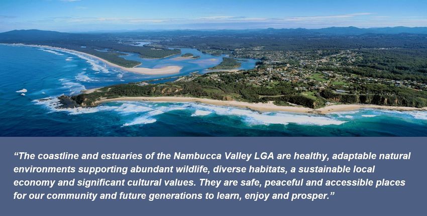
Nambucca Coastline and Estuaries Coastal Management Program

 Issue Category                 ID     High priority threats

 Estuarine bank erosion         T12    Flooding

                                T15    Historic clearing of riparian vegetation and adjacent habitat

                                T16    Uncontrolled stock access to and grazing within the riparian zone

 Riparian vegetation and        T19    Dominance of invasive weeds
 weed management
                                T16    Uncontrolled stock access to and grazing within the riparian zone

                                T15    Historic clearing of riparian vegetation and adjacent habitat

 Entrance management,           T40    Siltation affecting navigation, water quality (reduced flushing) and aesthetics
 shoaling and estuary
                                T41    Shoaling of marine sands affecting navigation and marine safety
 hydraulics
                                T44    Dangerous currents

 Threats to biodiversity        T45    Removal, fragmentation and degradation of riparian and adjacent habitat

                                T46    Removal of instream (e.g. dead wood) and reef habitat

                                T47    Predation and invasion by introduced animals and exotic plants

                                T49    Overgrazing by stock resulting in reduction in groundcover, enabling erosion
                                       and compaction of soil

                                T55    Fire/ altered and inappropriate fire regimes/ frequent burning

 Water Quality                  T65    Agricultural diffuse source runoff (runoff from large areas of agricultural land
                                       with no specific point source)

                                T66    Urban stormwater pollution and lack of maintenance of existing controls

                                T67    Sewer surcharge and STP overflows

                                T77    Acid sulfate soils

 Cultural Heritage              T85    Threats to Aboriginal cultural practices and heritage

Coastal hazards such as beach erosion, coastline recession, coastal inundation, landslip and the migration
of creek and river entrances are key threats impacting the study area today. Due to the relatively
undeveloped nature of much of the Nambucca coastline, the coastal hazard risk is comparatively low
compared to other more populated coastal areas in NSW. However, these threats are projected to increase
over time as the gradual impacts of sea level rise result in the landward migration of the coastline and
increased risk of extreme storm events impacting the coastal zone. Key impacts are predicted to include
damage to assets, infrastructure and foreshore access, loss of dune vegetation, decreased amenity, public
safety risks and tourism impacts.

Entrance management, shoaling and estuary hydraulics are also key threats affecting values and uses of the
Nambucca coastal zone. Shoaling of the Nambucca River entrance is often raised as a community concern
due to restriction of boating navigation and maritime safety issues. Entrance management is also an ongoing
management consideration related to water quality and flooding issues. This is particularly a concern for the
estuaries containing low-lying built assets and private property such as Deep Creek, where an entrance
management policy is in place. Projected sea level rise and climate change are expected to impact estuary
entrances and increase the frequency and severity of catchment and coastal flooding/inundation. Adaptive
management approaches will be required to cater for this.

Climate change impacts will also result in a number of additional or emerging risks across the study area,
including altered estuary water temperatures, salinity profiles, habitat migration and modified storm
frequency and severity.

Bank instability and erosion within the estuaries contributes to loss of land, estuarine vegetation and riparian
habitat loss, increased sedimentation and water quality issues. The health of riparian zones also strongly

                                                                                                              Page II
Nambucca Coastline and Estuaries Coastal Management Program
influences estuarine geomorphic condition, biodiversity and the quality of water resources. The main threats
to riparian condition within the study area are the dominance of invasive weeds, livestock access and the
legacy of historic broad-scale riparian vegetation clearing. A number of other threats to biodiversity have also
been identified including increasing development, overgrazing, rubbish dumping and litter, invasive animals
and pesticide spray drift.
Water quality is one of the prime estuarine “health” indicators and a key value to community stakeholders,
many of whom are concerned about ongoing degradation of water quality from both point and diffuse
sources and the perception that water quality affects tourism in the area. Key issues include high turbidity,
high nutrient concentrations and low dissolved oxygen. Oyster leases are particularly susceptible to
sedimentation and bacterial contamination after rainfall and bacterial contamination is also a human health
risk for primary and secondary contact recreation.
Other threats and community concerns included:
The potential for increased hydrological stress in the catchment areas (particularly in the Deep Creek
catchment) due to increased water extraction associated with expanding horticulture in the region.
There are a range of views in the community regarding decline in fish stocks within the Nambucca
River estuary over many years. While there is currently a lack of definitive information regarding the
proportional impact of various factors, key contributors include commercial and recreational fishing,
local-scale habitat destruction and the decline in estuary health.
There are a number of highly valued public access assets within the study area including beach
access tracks and viewing platforms, lookouts, iconic footbridges, walkways and seawalls. Public
access issues identified are associated with overcrowding during peak summer use (e.g. parking),
accessibility for those with limited mobility and regular maintenance and repair of access ways
including following coastal erosion events.
A lack of knowledge of the impact of human activities on the natural values of the coastline and estuaries
has been identified as a barrier to effective management. This threat is exacerbated by high
tourism/visitation rates, a lack of coordination between land managers and limited resources for community
education and engagement. Lack of compliance with regulations has also been identified by the community
as an issue for management. Examples include unauthorised foreshore structures, breach of development
consent conditions, camping/vegetation damage in dunes, excessive or inappropriate boating speed and
usage, illegal fishing, littering, dogs off-leash in prohibited areas and unauthorised four-wheel drive access
on beaches.
This CMP provides a management framework that aims to protect the social, ecological and cultural values
associated with the Nambucca coastline and estuaries and to manage conflicting desires for the protection of
ecological values and recreational opportunities. The approach is consistent with the long-term vision, the
management objectives and community values. The CMP recognises that the coastal zone has suffered
impacts from past and current human use and faces current and future pressures including population
increases and natural influences such as flooding, sea level rise and climate change.
The CMP provides a suite of coastal planning and management actions that have been developed and
prioritised based on the assessed risk of the threats to the study area.
Actions consist of a combination of studies, investigations and on-ground works and were selected to
address the key risks. Actions are based on professional consideration of the legal, technical and
engineering feasibility, the economic viability and the acceptability of actions to the community and
stakeholders. This CMP includes 49 actions that have been developed from the short-listed options and
grouped into eleven key strategies for implementation:
1. Management and Governance (MG)
Page III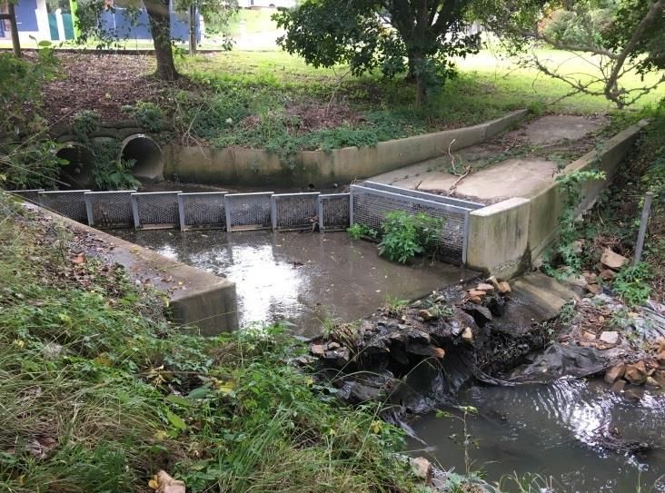
Nambucca Coastline and Estuaries Coastal Management Program

    2. Education and Consultation (EC)

    3. Local Planning and Development Controls (PD)

    4. Manage Risks Associated with Coastal Processes (CP)

    5. Improve Water Quality (WQ)

    6. Manage Bank Erosion, Protect and Rehabilitate Riparian Zones (BER)

    7. Improve Biodiversity Values (BV)

    8. Protect Cultural Heritage Values (CH)

    9. Facilitate Safe and Sustainable Recreational Use (RU)

    10. Actions to be Undertaken by Public Authorities (PA)

    11. Monitoring, Evaluation and Reporting (MER) Program

A Business Plan has been developed for the CMP which outlines the key components of the funding strategy
for the CMP, including the cost of proposed actions, proposed cost-sharing arrangements and other potential
funding mechanisms. Delivery of the Nambucca Coastline and Estuaries CMP is estimated to cost
$7,485,000 over 10 years.

The CMP actions are expected to be funded through NVC and state government contributions, monetary
grants and volunteer works by community members and organisations. Management actions have been
developed for a ten-year period and have been aligned with Council’s four-year Delivery Programs under the
NSW Integrated Planning and Reporting (IP&R) Framework. This CMP and the progress of the management
actions will be reviewed to ensure the actions remain relevant and the implementation of the plan is being
achieved.

                                                                                                Page IV
Nambucca Coastline and Estuaries Coastal Management Program
CONTENTS
1. INTRODUCTION................................................................................................................................. 1
1.1 Purpose and scope ............................................................................................................................. 1
1.1.1 Consultation undertaken as part of this CMP ................................................................................. 2
1.2 The Coastal Management Framework in NSW .................................................................................. 2
1.3 Areas covered by this CMP ................................................................................................................ 3
1.4 Vision, objectives and strategic direction ............................................................................................ 6
1.4.1 The vision for the Nambucca coastline and estuaries .................................................................... 6
1.4.2 CMP objectives ............................................................................................................................... 6
1.5 Existing management arrangements .................................................................................................. 8
1.6 Regional and local strategies ............................................................................................................10
1.6.1 North Coast Regional Plan 2036 ..................................................................................................11
1.6.2 Marine Estate Management Strategy ...........................................................................................11
1.6.3 Previous coastline and estuary management plans .....................................................................11
1.6.4 Integrated Planning and Reporting ...............................................................................................12
2. PROCESSES, VALUES AND THREATS ......................................................................................... 13
2.1 Physical character .............................................................................................................................13
2.1.1 Open coast ...................................................................................................................................13
2.1.2 Nambucca River estuary ..............................................................................................................13
2.1.3 ICOLLs ..........................................................................................................................................14
2.2 Community values and uses of the coastal zone .............................................................................15
2.2.1 Culture and heritage .....................................................................................................................16
2.3 Key threats ........................................................................................................................................17
2.3.1 Community concerns ....................................................................................................................17
2.3.2 Coastal hazards ............................................................................................................................19
2.3.3 Entrance management, shoaling and estuary hydraulics.............................................................21
2.3.4 Climate change impacts ...............................................................................................................22
2.3.5 Estuarine bank erosion .................................................................................................................23
2.3.6 Riparian vegetation and weed management ................................................................................24
2.3.7 Threats to biodiversity ..................................................................................................................26
2.3.8 Water quality .................................................................................................................................27
2.3.9 Hydrology, connectivity and water extraction ...............................................................................29
2.3.10 Governance, education and compliance ..................................................................................29
Page iNambucca Coastline and Estuaries Coastal Management Program
2.3.11 Influence of projected population growth, demographic changes and future use of land within
the study area ........................................................................................................................................... 30
2.4 Risk assessment .............................................................................................................................. 31
3. COASTAL MANAGEMENT ACTIONS ..............................................................................................37
3.1 Assessment of coastal management options ................................................................................... 37
3.2 Development of management strategies and actions ...................................................................... 38
3.3 Actions to be implemented by Council ............................................................................................. 39
3.4 Actions to be undertaken by public authorities ................................................................................. 39
3.5 Monitoring, Evaluation and Reporting Program ............................................................................... 39
3.6 Whether the CMP identifies recommended changes to the relevant planning controls, including any
proposed maps............................................................................................................................................. 47
4. BUSINESS PLAN ..............................................................................................................................48
5. COASTAL ZONE EMERGENCY ACTION SUB PLAN .....................................................................54
6. MAPS ................................................................................................................................................55
REFERENCES .................................................................................................................................................60
GLOSSARY AND ABBREVIATIONS ...............................................................................................................63
APPENDIX 1. EMERGENCY ACTION SUBPLAN ......................................................................................65
APPENDIX 2. COASTAL MANAGEMENT PROGRAM CHECKLIST .........................................................67
FIGURES
Figure 1: Coastal management framework ....................................................................................................... 3
Figure 2: The Nambucca CMP study area ........................................................................................................ 4
Figure 3: The Nambucca CMP study area showing the connected catchments of the estuaries and coastal
creeks and LGA boundary ................................................................................................................................. 5
Figure 4: Regional and local strategies and management plans for Nambucca coastal and estuary
management .................................................................................................................................................... 10
Figure 5: Bank instability extent across the study area ................................................................................... 24
Figure 6: Riparian condition extent across the study area .............................................................................. 25
Figure 7: Left: Gross Pollutant Trap at Bellwood Park; Right: damaged floodgate at East Street, Macksville
(July 2018) ....................................................................................................................................................... 29
Figure 8: Coastal Management Areas for the Nambucca coastline and estuaries ......................................... 56
Figure 9: Secondary coastal sediment compartments relevant to the study area .......................................... 57
Figure 10: Existing land management responsibility for public land ................................................................ 58
Figure 11: Urban growth area map for the Nambucca Local Government Area ............................................. 59
Page iiNambucca Coastline and Estuaries Coastal Management Program
PLATES
Plate 1: Nambucca Valley Council Acknowledgement to Country ...................................................................... I
Plate 2: Deep Creek footbridge .......................................................................................................................... 1
Plate 3: Nambucca coastline, Wellington Rock ................................................................................................13
Plate 4: Nambucca River Estuary ....................................................................................................................14
Plate 5: Left: Oyster Creek; Right: Deep Creek ...............................................................................................15
Plate 6: Left: The V-Wall, a popular, easily accessible fishing spot with deep-water access. Right: 4WD
beach access at South Beach ..........................................................................................................................16
Plate 7: Left: Nambucca Main Beach Surf Club access stairs damaged by storm events; Right: Main Beach
Surf Club after replacement of access stairs....................................................................................................19
Plate 8: Left: Vegetation debris on receding shoreline north of Swimming Creek entrance (December 2018);
Right: recession of beach at Ulrick Drive carpark (north end of Beilby’s Beach) causing undercutting and
collapse of the road surface (July 2018) ..........................................................................................................20
Plate 9: Left: Tidal inundation of Stuarts Island causeway (December 2012); Right: Inundation of the
foreshore of Bellwood Park (December 2012) .................................................................................................21
Plate 10: Erosion control at Swimming Creek entrance (September 2018) .....................................................22
Plate 11: Left: Unstable unconsolidated sand banks in Warrell Creek (July 2018); Right: Severe bank
instability and undercutting on the South Arm, upstream of Bowraville (July 2018) ........................................24
Plate 12: Left: Parrots Feather and Hymenachne in the Nambucca River at East Bowraville (July 2018);
Right: Riparian revegetation on Stuart Island...................................................................................................26
Plate 13: Left - Bank erosion mitigation; Right – Coastal viewing platform ......................................................37
TABLES
Table 1: High priority threats identified by the risk assessment .......................................................................... I
Table 2: Nambucca coastline and estuaries local management objectives ....................................................... 7
Table 3: Risk assessment results for Nambucca coastline and estuaries .......................................................32
Table 4: High priority threats identified by the risk assessment .......................................................................36
Table 5: Priority Ranking ..................................................................................................................................38
Table 6: Management actions to be implemented by Council .........................................................................40
Table 7: Management actions to be implemented by public authorities ..........................................................45
Table 8: Monitoring, Evaluation and Reporting Program .................................................................................45
Table 9: Business Plan .....................................................................................................................................51
Table 10: Section 1 Statutory requirements set out in the Coastal Management Act 2016 ............................69
Table 11: Section 2 Mandatory Requirements set out in NSW Coastal Management Manual (2018) – Part A
..........................................................................................................................................................................71
Table 12: Management objectives for the coastal wetlands and littoral rainforests area (Section 6 Coastal
Management Act 2016) ....................................................................................................................................77
Page iiiNambucca Coastline and Estuaries Coastal Management Program
Table 13: Management objectives for the coastal environment area (Section 8 Coastal Management Act
2016) ................................................................................................................................................................ 78
Table 14: Management objectives for the coastal use area (Section 9 Coastal Management Act 2016)....... 79
Page ivNambucca Coastline and Estuaries Coastal Management Program
1. INTRODUCTION
1.1 Purpose and scope
Nambucca Valley Council (NVC) has prepared this Coastal Management Program (CMP) to set the long-
term strategy for the coordinated management of the Nambucca coastline and estuaries with a focus on
achieving the relevant objectives for each coastal management area from the Coastal Management Act 2016
(CM Act). This CMP incorporates management actions and strategies to address key threats and support a
diversity of natural values and human uses for a range of timeframes (immediate, 20 years, 50 years and
100 years). Management actions have been developed for the next ten years to balance and manage uses
so that they are compatible with the environmental, social and economic values of the Nambucca Valley
coastal zone. Longer-term pressures such as climate change and sea level rise have been considered in the
formulation of management actions to ensure resilience against future threats and the conservation of these
values for future generations.
This CMP has been developed in accordance with Stages 1 to 4 of the five-stage process for developing and
implementing a CMP, as detailed in the Coastal Management Manual (OEH, 2018). The completed stages
supporting this CMP include:
Stage 1 Scoping Study (Hydrosphere Consulting, 2020a) which reviewed the status of current issues
and management and identifies the focus of the new CMP.
Stage 2 Vulnerabilities and Opportunities Study (Hydrosphere Consulting, 2020b) incorporating a
bank condition assessment of the study area to determine and assess estuary bank erosion risks,
vulnerabilities and opportunities and inform future management.
Stage 3 Options Assessment (Hydrosphere Consulting, 2020c) which identified and assessed
actions to address coastal management issues in an integrated and strategic manner consistent with
the provisions of the CM Act.
Plate 2: Deep Creek footbridge
Source: Tango Print and Design in NVC (2020).
Page 1Nambucca Coastline and Estuaries Coastal Management Program
1.1.1 Consultation undertaken as part of thi s CMP
Consultation with the community, public authorities and NVC has been undertaken in accordance with a
communication and engagement strategy prepared for this CMP. A community survey was conducted during
CMP development to engage the community in the project, identify community issues and concerns and
facilitate ideas. A public drop-in session was undertaken during the community survey period. Submissions
were also received from stakeholders and community members either via mail, email or via the web contact
form from the dedicated project webpage. Submissions from key agencies included MIDO, DPI Fisheries,
Forestry Corporation of NSW and DPIE - NPWS Landforms and Rehabilitation Unit. Outcomes of the
consultation activities are discussed in detail in the Stage 1 Scoping Study (Hydrosphere Consulting 2020a).
The actions and strategies in this CMP have been developed to target the issues and threats identified
during consultation activities and to preserve the community values of the Nambucca coastline and
estuaries, detailed in Section 2.1.
1.2 The Coastal Management Framew ork in NSW
The CM Act establishes the framework and overarching objects for coastal management in NSW and
supports the aims of the Marine Estate Management Act 2014 (MEM Act) to provide for strategic and
integrated management of the whole marine estate – marine waters, coasts and estuaries. The CM Act
communicates the NSW Government's vision for coastal management and reflects the vital natural, social,
cultural and economic values of our coastal areas and promotes the principles of ecologically sustainable
development in managing these values.
The CM Act establishes requirements for the preparation of CMPs. The State Environmental Planning Policy
(Coastal Management) 2018 (CM SEPP) forms part of the broader land-use planning framework in NSW.
This is now the key environmental planning instrument for land-use planning in the coastal zone and delivers
the statutory management objectives for each of the four coastal management areas that make up the
coastal zone (and which are set out in the CM Act). Mapping of these areas within the CMP study area are
presented in Figure 8 (Section 6). The objectives for this CMP (refer Section 1.4.2) are aligned with the
objectives of the CM SEPP as demonstrated in Appendix 1.
The legislative and policy framework introduced by recent coastal reforms recognises natural coastal
processes and the local and regional dynamic character of the coast and promotes land use planning
decisions that accommodate them. The reforms ensure coordinated planning and management of the coast
and support public participation in these activities (Figure 1). Further details on the NSW Coastal
Management Framework is provided in the Stage 1 Scoping Study (Hydrosphere Consulting, 2020a).
Page 2Nambucca Coastline and Estuaries Coastal Management Program
Environmental Planning and
Assessment Act 1979
NSW Coastal Management Framework
Local Government Act 1993
Coastal Management Crown Land Management Act 2016
Act 2016 Coastal Management
Marine Estate Manual
Aboriginal Land Rights Act 1983
Management Act 2014
SEPP Coastal
Marine Estate Management 2018 National Parks and Wildlife Act 1974
Management Strategy
2018 - 2028
Fisheries Management Act 1994
Coastal and
Estuary NSW Coastal Local Land Services Act 2013 and
Grants Council Amendment Act 2016
Program
Biodiversity Conservation Act 2016
Native Title Act 1993
Coastal Management (Commonwealth)
Programs
Environment Protection and
Biodiversity Conservation Act 1999
(Commonwealth)
Figure 1: Coastal management framework
1.3 Areas covered by this CMP
Nambucca Valley LGA is located on the Mid North Coast of NSW, approximately halfway between Brisbane
and Sydney and 45 km south of Coffs Harbour. This CMP is made in relation to the coastal zone shown in
Figure 2, comprising the coastal areas, tidal waterways, foreshores and adjacent lands within the Nambucca
Valley LGA.
The Nambucca coastline includes 25 km of beaches, dunes, headlands, rock platforms and bluffs from North
Valla Beach (immediately south of the entrance to Oyster Creek) and southwards to Scotts Head. The study
area also includes the estuaries of the Nambucca River, Oyster Creek, Deep Creek and Swimming Creek.
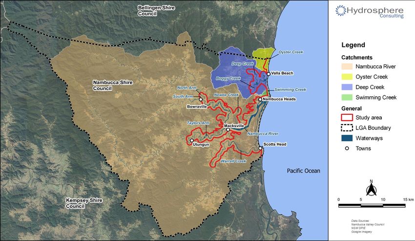
The upper catchments are included in the study area to address threats that have the potential to impact on
downstream values. The majority of the waterway catchments of the study area are located within the
Nambucca Valley LGA with the exception of approximately half of the Oyster Creek catchment and small
areas of the upper Nambucca River estuary catchment which are within Bellingen Shire Council area (Figure
3).
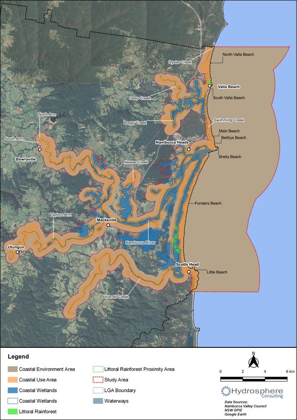
Mapping of coastal management areas within the study area is shown on Figure 8 (Section 6). This CMP
encompasses the coastal management areas mapped within the Coastal Management State Environmental
Planning Policy 2018 (CM SEPP):
Coastal Wetlands and Littoral Rainforest Area.
Coastal Environment Area.
Coastal Use Area.
Although the Coastal Vulnerability Area is not mapped in the CM SEPP, the coastline is subject to coastal
hazards and these have also been addressed in this CMP.
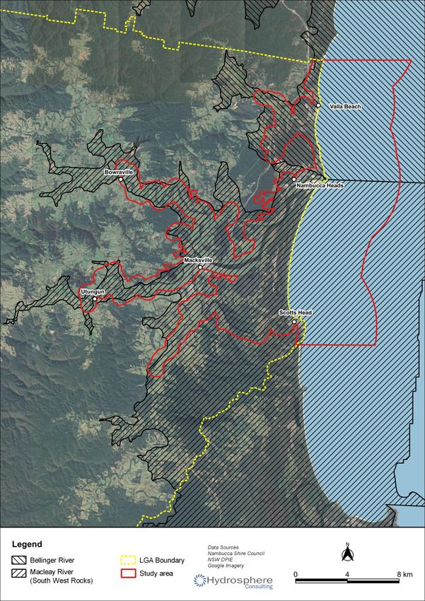
The Nambucca coastline sits across two secondary coastal sediment compartments, the Bellinger River and
the Macleay (South West Rocks) compartments (refer Figure 9, Section 5) which NVC shares with Bellingen,
Coffs Harbour and Kempsey LGAs.
Page 3Nambucca Coastline and Estuaries Coastal Management Program
Figure 2: The Nambucca CMP study area
Page 4Nambucca Coastline and Estuaries Coastal Management Program
Figure 3: The Nambucca CMP study area showing the connected catchments of the estuaries and coastal creeks and LGA boundary
Page 5Nambucca Coastline and Estuaries Coastal Management Program
1.4 Vision, objectives and strategic direction
1.4.1 The vision for the Nambucca coastline and est uaries
The vision statement developed for the Nambucca CMP, consistent with the state’s vision and Council’s
overall strategic direction and community input is as follows:
1.4.2 CMP objecti ves
Part 1, Section 3 of the CM Act states “the objects of this Act are to manage the coastal environment of New
South Wales in a manner consistent with the principles of ecologically sustainable development for the
social, cultural and economic well-being of the people of the State”. It also sets out 13 objects of the CM Act
that must be considered and promoted when preparing a CMP. The values of Nambucca stakeholders and
community were identified through consultation undertaken as part of this CMP and are consistent with the
CMP Act objectives. The 13 objects of the CM Act and the objectives of the four coastal management areas
have been incorporated in this CMP (refer Appendix 1 for details).
Local management objectives for the Nambucca coastline and estuaries have been developed to guide this
CMP (Table 2). The objectives have been adapted and collated from the previous Nambucca River Estuary
Management Plan (BMT WBM, 2008) and the Nambucca Shire CZMP (Umwelt, 2012) and updated to reflect
current day community uses and values associated with the coastline and estuaries.
Page 6Nambucca Coastline and Estuaries Coastal Management Program
Table 2: Nambucca coastline and estuaries local management objectives
Values CMP Objective
Coastal risk and 1. to minimise risks associated with coastal processes, protect important community
adaptation to climate
values and enable residents and visitors to continue to be able to enjoy safe access to
change
an attractive healthy coastal landscape.
2. to guide Council land use and land management strategies and actions so that coastal
hazards are taken into account for short and long-term timeframes.
3. to provide good value investment in Council assets in the coastal zone, so that
infrastructure for coastline access and enjoyment is good quality, and meets the needs
of residents and visitors.
4. to provide clear information about coastal processes and hazards and support
community involvement in planning future activities in the coastal zone.
5. to consider the potential implications of sea level rise on the estuary and its surrounds
as a result of climate change.
Water quality 6. to maintain and improve water quality within the estuaries and their catchments to
support ecosystem function, commercial fishing/oyster production, tourism, and human
recreation including swimming.
Natural habitats and 7. to protect and enhance habitats to improve the health, biodiversity and scenic value of
biodiversity the Nambucca coastline and estuaries.
8. to encourage and support strategies to improve the health and resilience of the
Nambucca coastline, estuaries and respective catchment areas.
Bank erosion 9. Improve overall riverbank condition on all major streams and waterways of the
Nambucca Valley to limit future bank erosion.
Cultural heritage and 10. to protect areas and items of Aboriginal and European cultural heritage.
practice 11. to understand, protect and respect the aboriginal heritage value of the Nambucca
coastline and estuaries including aboriginal peoples’ spiritual, social, customary and
economic use of the coastal zone.
Community uses, public 12. to protect and enhance the recreational, scenic, social and cultural values of the
access and amenity coastline and estuaries.
13. to maintain and improve public access and safety, facilities and infrastructure.
14. to maintain navigation within the lower estuary for shallow draft vessels, consistent
with current use.
15. encourage waterway use that causes a minimum of environmental and social impact,
and where possible, enhances user amenity through improved safety controls and
reduced conflict.
Education, engagement 16. to actively engage with the community to achieve greater awareness, education and
and public opinion understanding of management issues and actions.
17. To maintain open lines of communication with the community and local Aboriginal
groups in relation to the ongoing management of the estuary.
18. to support public participation in the coastal management and planning process.
Land use planning 19. protect and enhance the existing uses and values of the Nambucca coastline and
estuaries in both the short- and long-term by adoption of best practice land use
planning and development controls.
Local economy, jobs 20. to maintain and improve the viability of existing (and potential future) types of
and prosperity ecologically and commercially sustainable estuary-based industries and enterprises.
(achieving objectives 1-19 will contribute to local economic values through enhanced
tourism and associated business activity).
Page 7Nambucca Coastline and Estuaries Coastal Management Program
1.5 Existing management arrangements
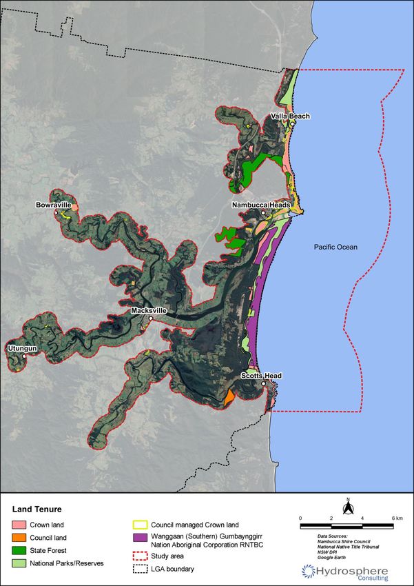
Existing land tenure (public) within the study area is shown on Figure 10 (Section 6). Most of the Nambucca
coastline and land immediately landward of the hind dune is in public ownership as National Park, Crown
Reserve or Council managed Crown Land (community land). Land adjoining the estuaries is predominantly
privately owned with small areas of Crown Land, and a large parcel of land under Native Title by the
Gumbaynggirr people in lower Warrell Creek. Within the wider catchments, the majority of land is privately
owned with significant areas of State Forest, encompassing approximately 22% of the broader
Nambucca/Warrell/Taylors Arm catchment and National Park extending over a further 17%. Private land also
dominates the Deep Creek catchment with National Parks and State Forests comprising 6% and 14% of the
catchment, respectively. The remainder of land in both catchments constitutes a variety of Crown Land and
road reserves.
The following organisations, community groups, industry groups and government agencies have a role in the
management of study area and the surrounding catchment.
NVC has a central role in managing the coastline and estuaries and is responsible for preparing the
Nambucca CMP which sets out the long-term strategy for management of the coastal zone. NVC is
also directly responsible for managing Council assets and infrastructure and land dedicated as
Crown reserves under its jurisdiction.
Gumbaynggirr people – Native Title by the Gumbaynggirr people exists over South Beach (also
known as Forster Beach) and adjacent land to the east of Warrell Creek and the Gumma Peninsula
and Islands in the lower Nambucca River estuary (refer Figure 2). The traditional owners of the study
area are committed to the sustainable management of these areas.
Nambucca Local Aboriginal Land Council (LALC) region extends from the northern boundary of the
Nambucca LGA south to Macksville. The tradditional owners manage Gumma Indigenous Protection
Area (IPA) comprising much of Gumma Point along with three small islets in the lower Nambucca
River estuary and is dedicated by its traditional owners, the Baga Baga and Ngambaa clan of the
Gumbaynggirr people, for biodiversity conservation and cultural heritage protection.
Unkya LALC region extends from Macksville, south to Scotts Head.
Bowraville LALC region covers the mid and upper Nambucca River catchment including the town of
Bowraville.
The Department of Planning, Industry and Environment – Environment, Energy and Science (DPIE –
EES) works closely with local councils and communities to reduce threats from flood risk and coastal
storms and ensures that people in NSW are well informed about these risks and better equipped to
adapt to climate change. DPIE – EES also works with local councils and communities to maintain or
improve the health of estuaries/ lakes and enhance the recreational experience.
DPIE – Crown Lands is directly responsible for management of all submerged land (the beds of
rivers, lakes and lagoons) and Crown reserves within the study area. DPIE – Crown Lands appoints
Crown Land managers and ensures that Crown Land is administered and managed in accordance
with the Crown Land Management Act 2016. Any actions in the CMP that are located on or affect
Crown Land that is administered by DPIE - Crown Lands, will require authorisation under the Crown
Land Management Act 2016 (e.g. leases and licences).
National Parks and Wildlife Service (NPWS) is directly responsible for management of National
Parks Estate under the National Parks and Wildlife Act 1974 (refer Figure 10).
The NSW Department of Primary Industries – Fisheries (DPI Fisheries) administers the Fisheries
Management Act 1994 (FM Act) and the MEM Act and has jurisdiction over all fish (including
oysters, crustaceans, polychaetes), and marine vegetation (saltmarsh, mangroves, seagrass and
Page 8Nambucca Coastline and Estuaries Coastal Management Program
macroalgae) in State Waters including ‘water land’ below HAT in the estuaries and extending up to 3
nautical miles offshore.
Under the FM Act, DPI Fisheries:
o Supports economic growth and sustainable access to aquatic resources through commercial
and recreational fisheries management, research, aquaculture development, habitat
protection and rehabilitation, regulation and compliance.
o Mitigates and manages risks from use of land and water.
Under the MEM Act, DPI Fisheries is responsible for:
o Ensuring strategic and integrated management of the whole marine estate –marine waters,
coasts and estuaries.
o Fisheries and aquaculture management, marine biodiversity, marine protected areas,
biosecurity, marine estate research, fisheries compliance, marine estate communications
and community engagement.
The Marine Estate Management Authority (MEMA) advises the NSW Government on the
management of the NSW marine estate under the Marine Estate Management Act 2014. The
Authority brings together the heads of the NSW Government agencies with key marine estate
responsibilities (DPI, DPIE (EES and Planning and Assessment) and Transport for NSW, TfNSW).
MEMA ensures policies and programs address priority issues, are well coordinated, efficient,
evidence based and result in positive outcomes and undertakes threat and risk assessments,
develops management strategies, promotes collaboration between public authorities and fosters
consultation with the community
Forestry Corporation of NSW leads policy, industry development, science and research for the NSW
wood and product manufacturing industry.
TfNSW – Maritime is the key agency with statutory and policy responsibilities related to the safety
and accessibility of NSW waterways for recreational and commercial vessels.
The Maritime Infrastructure Delivery Office (MIDO) is a joint initiative between DPIE – Crown Lands
and TfNSW. A number of relevant DPIE – Crown Lands’ programs are currently managed through
MIDO including:
o Coastal Infrastructure Program (i.e. management of the lower estuary v-wall, breakwall and
training walls).
o Rescuing our Waterways dredging program.
North Coast Local Land Services (NCLLS) plays a key role in the management of catchment
activities and natural resources relevant to estuary catchments and through the facilitation of
relationships between landholders and key environmental organisations.
Nambucca Valley Landcare (NVL) is a non-profit community organisation which encourages and
supports sustainable natural resource management within the Nambucca River catchment. The
organisation undertakes a range of projects with landholders, volunteer groups, and government
agencies including river restoration, farm planning and bush regeneration.
Scotts Head Dunecare - a non-profit community organisation undertaking dune rehabilitation, bank
stabilisation and dune revegetation within the vicinity of Scotts Head.
Valla Beach Bushcare - a non-profit community organisation undertaking dune rehabilitation, bank
stabilisation and bushland revegetation within the vicinity of Valla Beach.
Page 9Nambucca Coastline and Estuaries Coastal Management Program
Nambucca River Oyster Farmers – there are three areas in the Nambucca River between Macksville
and Nambucca Heads classified by the NSW Food Authority for the harvesting of oysters.
NSW Crown Holiday Parks – there are two holiday parks located on Crown Land within the study
area managed by Reflections (NSW Crown Holiday Parks) at Scotts Head and Nambucca Heads.
Nambucca River, Creeks, Estuaries and Coastline Management Committee (NRCECMC). The
Committee is represented by key local stakeholder groups including government organisations,
Councillors, the three LALCs and special environmental and interest groups. The committee ensures
that the interests and views of these groups are understood and provides advice to Council on
coastal and estuary management.
1.6 Regional and local strategies
The study area is currently managed in accordance with various regional and local level planning
instruments, strategies and management plans implemented by Council and other stakeholders. Figure 4
provides an outline of the key management plans and documents relevant to this CMP. The status of the
recommended actions in the current plans is detailed in the Stage 1 Scoping Study (Hydrosphere
Consulting, 2020a).
Figure 4: Regional and local strategies and management plans for Nambucca coastal and estuary
management
Page 10Nambucca Coastline and Estuaries Coastal Management Program
There also are numerous other management programs being implemented by NVC, government agencies,
statutory bodies and community groups addressing components of estuary and coastal zone management in
parallel with the primary management plans and programs.
1.6.1 North Coast Regional Plan 2036
The North Coast Regional Plan 2036 (DPE, 2017) provides an overarching strategy for the next two decades
that reflects community and stakeholder aspirations and opportunities for the North Coast region. The Plan
identifies several aims relevant to the Nambucca coastline and estuaries including:
Goal 1 – The most stunning environment in NSW. The Nambucca coastline and estuaries provide
not only intrinsic value but contain highly valued natural areas which improve community lifestyles,
health and wellbeing. The areas natural resources contribute to a significant tourism industry which
capitalises on the natural assets of the region.
Direction 2 - Enhance biodiversity, coastal and aquatic habitats, and water catchments. The
Nambucca coastline and estuaries are identified as one of the areas of high environmental value that
is integral to maintaining the biological diversity of the North Coast. The Plan recommends using an
evidence-based approach to protecting important assets that will help to maintain diversity and
habitat for flora and fauna.
Direction 3 - Manage natural hazards and climate change. The Plan identifies a number of threats
and hazards relevant to Nambucca coastline and estuaries including coastal erosion, sea level rise,
storms and floods. The Plan acknowledges CMPs and associated controls as the key planning
mechanism to deal with these hazards, increase all-hazard disaster preparedness and build
community capacity and resilience.
1.6.2 Marine Estate Management Strat egy
The Marine Estate Management Strategy 2018-2028 (MEMS, MEMA, 2018) provides an overarching
strategic approach to the coordinated management of the NSW marine estate, i.e. the coastal waters,
estuaries, lakes, lagoons and coastal wetlands. The Strategy considers the ten MEMS management
principles as well as priority threats for the marine estate as identified in the NSW marine estate threat and
risk assessment (TARA, BMT WBM, 2017).
Stage 1 of the MEMS focused on addressing the most severe threats to the health of the marine estate,
particularly water pollution, which was identified as the greatest threat to the marine estate by the NSW
community and through the evidence-based TARA (BMT WBM, 2017). Some MEMS management actions
have included pilot projects in Stage 1 in specific locations along the NSW coast. Other management actions
have state-wide benefits, such as the application of a risk-based framework for water quality in estuaries and
their main tributaries.
1.6.3 Previous coastline and est uary management plans
The two core local management plans are the Nambucca Coastal Zone Management Plan (Umwelt, 2012)
(certified) and the Nambucca River Estuary Management Plan (BMT WBM, 2008). No specific estuary
management plan is presently in place for the Deep Creek estuary however the entrance is managed in
accordance with the Deep Creek Entrance Management Policy (NSW, 2013). More recently, the report for
the Nambucca EcoHealth Project 2016-2017 (Mika et al., 2018) provides management recommendations for
the Nambucca and Deep Creek estuaries relating to hydrology, water quality, riparian vegetation and
geomorphic condition. Management of Swimming Creek was previously provided for in the Swimming Creek
Plan of Management (NSC, 1995). This CMP has been developed through consideration of the existing
Page 11Nambucca Coastline and Estuaries Coastal Management Program
management arrangements. In some cases, this CMP updates and improves various management
strategies with current knowledge and understanding of issues.
1.6.4 Integrated Planning and Reporting
The Integrated Planning and Reporting (IP&R) framework is established under Chapter 13 of the Local
Government Act 1993 and is the main mechanism by which councils comprehensively plan for and report on
their asset management and service delivery responsibilities. The CM Act requires that CMPs are given
effect through the IP&R framework. This will include performance auditing powers to ensure that programs
are appropriately implemented. This means that CMPs and identified coastal management activities are
aligned with broader community strategic plans, reflect community priorities, and are feasible, financially
viable and able to be resourced.
The Nambucca Valley: Living at its Best 2027 Community Strategic Plan (CSP), sits above all other Council
plans and policies in the planning hierarchy. The CSP identifies long term priorities, outcomes and
aspirations for the future of the community and the local government area. Council uses this document to
guide and inform their decision making and planning for at least the next ten years. The NVC Local Strategic
Planning Statement (LSPS) (NVC, 2020) provides a vision for the Nambucca Valley, details the special
characteristics which contribute to local identity and shared community values and provides a summary of
actions to manage growth and change into the future. The Delivery Program and Operational Plan identifies
all key activities to be undertaken by Council during its elected term, and which year the activities are to be
undertaken. The CSP has assisted in guiding the development of the Nambucca CMP through its strong
aspiration to care for the natural environment. The CMP actions have been organised and scheduled with
consideration of NVC’s IP&R framework, Delivery Program and Operational Plan and associated reporting
requirements.
Page 12You can also read