National Hydrometric Monitoring Programme 2018-2021 - EPA
←
→
Page content transcription
If your browser does not render page correctly, please read the page content below
National Hydrometric Monitoring Programme
2018-2021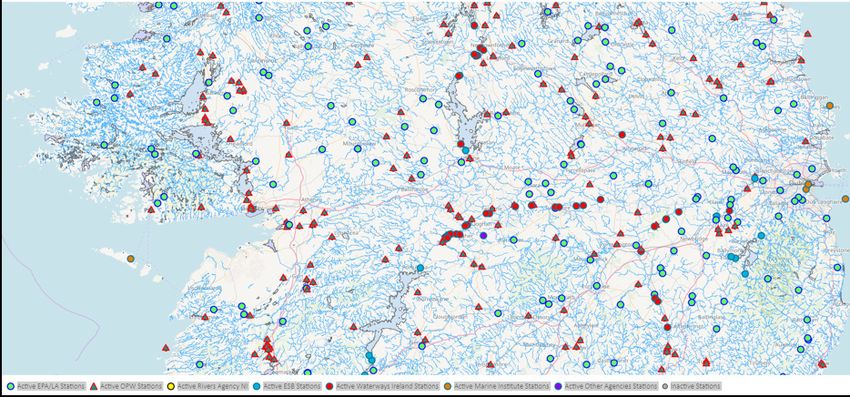
National Hydrometric Monitoring Programme 2018-2021                                                                    Environmental Protection Agency

ENVIRONMENTAL PROTECTION AGENCY                                                  Regulating Ireland’s Greenhouse Gas Emissions
                                                                                 ■■   Preparing Ireland’s greenhouse gas inventories and projections.
The Environmental Protection Agency (EPA) is responsible for
protecting and improving the environment as a valuable asset for the             ■■   Implementing the Emissions Trading Directive, for over 100 of the
people of Ireland. We are committed to protecting people and the                      largest producers of carbon dioxide in Ireland.
environment from the harmful effects of radiation and pollution.
                                                                                 Environmental Research and Development
The work of the EPA can be divided into                                          ■■   Funding environmental research to identify pressures, inform policy
three main areas:                                                                     and provide solutions in the areas of climate, water and sustainabil-
                                                                                      ity.
Regulation: We implement effective regulation and environmental
compliance systems to deliver good environmental outcomes and                    Strategic Environmental Assessment
target those who don’t comply.
                                                                                 ■■   Assessing the impact of proposed plans and programmes on the
Knowledge: We provide high quality, targeted and timely                               Irish environment (e.g. major development plans).
environmental data, information and assessment to inform decision
making at all levels.                                                            Radiological Protection
                                                                                 ■■   Monitoring radiation levels, assessing exposure of people in Ireland
Advocacy: We work with others to advocate for a clean, productive
                                                                                      to ionising radiation.
and well protected environment and for sustainable environmental
behaviour.                                                                       ■■   Assisting in developing national plans for emergencies arising from
                                                                                      nuclear accidents.
OUR RESPONSIBILITIES                                                             ■■   Monitoring developments abroad relating to nuclear installations
                                                                                      and radiological safety.
Licensing                                                                        ■■   Providing, or overseeing the provision of, specialist radiation
We regulate the following activities so that they do not endanger                     protection services.
human health or harm the environment:
                                                                                 Guidance, Accessible Information and Education
■■   waste facilities (e.g. landfills, incinerators, waste transfer stations);
                                                                                 ■■   Providing advice and guidance to industry and the public on envi-
■■   large scale industrial activities (e.g. pharmaceutical, cement manu-
                                                                                      ronmental and radiological protection topics.
     facturing, power plants);
                                                                                 ■■   Providing timely and easily accessible environmental information to
■■   intensive agriculture (e.g. pigs, poultry);
                                                                                      encourage public participation in environmental decision-making
■■   the contained use and controlled release of Genetically Modified                 (e.g. My Local Environment, Radon Maps).
     Organisms (GMOs);                                                           ■■   Advising Government on matters relating to radiological safety and
■■   sources of ionising radiation (e.g. x-ray and radiotherapy equip-                emergency response.
     ment, industrial sources);                                                  ■■   Developing a National Hazardous Waste Management Plan to
■■   large petrol storage facilities;                                                 prevent and manage hazardous waste.
■■   waste water discharges;
■■   dumping at sea activities.                                                  Awareness Raising and Behavioural Change
                                                                                 ■■   Generating greater environmental awareness and influencing
National Environmental Enforcement                                                    positive behavioural change by supporting businesses, communities
                                                                                      and householders to become more resource efficient.
■■   Conducting an annual programme of audits and inspections of EPA
     licensed facilities.                                                        ■■   Promoting radon testing in homes and workplaces and encourag-
                                                                                      ing remediation where necessary.
■■   Overseeing local authorities’ environmental protection responsi-
     bilities.
                                                                                 Management and structure of the EPA
■■   Supervising the supply of drinking water by public water suppliers.
                                                                                 ■■   The EPA is managed by a full time Board, consisting of a Director
■■   Working with local authorities and other agencies to tackle envi-                General and five Directors. The work is carried out across five
     ronmental crime by co-ordinating a national enforcement network,                 Offices:
     targeting offenders and overseeing remediation.
                                                                                 ■■   Office of Environmental Sustainability
■■   Enforcing Regulations such as Waste Electrical and Electronic
                                                                                 ■■   Office of Environmental Enforcement
     Equipment (WEEE), Restriction of Hazardous Substances (RoHS)
     and substances that deplete the ozone layer.                                ■■   Office of Evidence and Assessment
■■   Prosecuting those who flout environmental law and damage the                ■■   Office of Radiation Protection and Environmental Monitoring
     environment.                                                                ■■   Office of Communications and Corporate Services
                                                                                 ■■   The EPA is assisted by an Advisory Committee of twelve members
Water Management
                                                                                      who meet regularly to discuss issues of concern and provide advice
■■   Monitoring and reporting on the quality of rivers, lakes, transitional           to the Board.
     and coastal waters of Ireland and groundwaters; measuring water
     levels and river flows.
■■   National coordination and oversight of the Water Framework
     Directive.
■■   Monitoring and reporting on Bathing Water Quality.

Monitoring, Analysing and Reporting on the
Environment
■■   Monitoring air quality and implementing the EU Clean Air for
     Europe (CAFÉ) Directive.
■■   Independent reporting to inform decision making by national and
     local government (e.g. periodic reporting on the State of Ireland’s
     Environment and Indicator Reports).

                                                                                                                                                              Page 2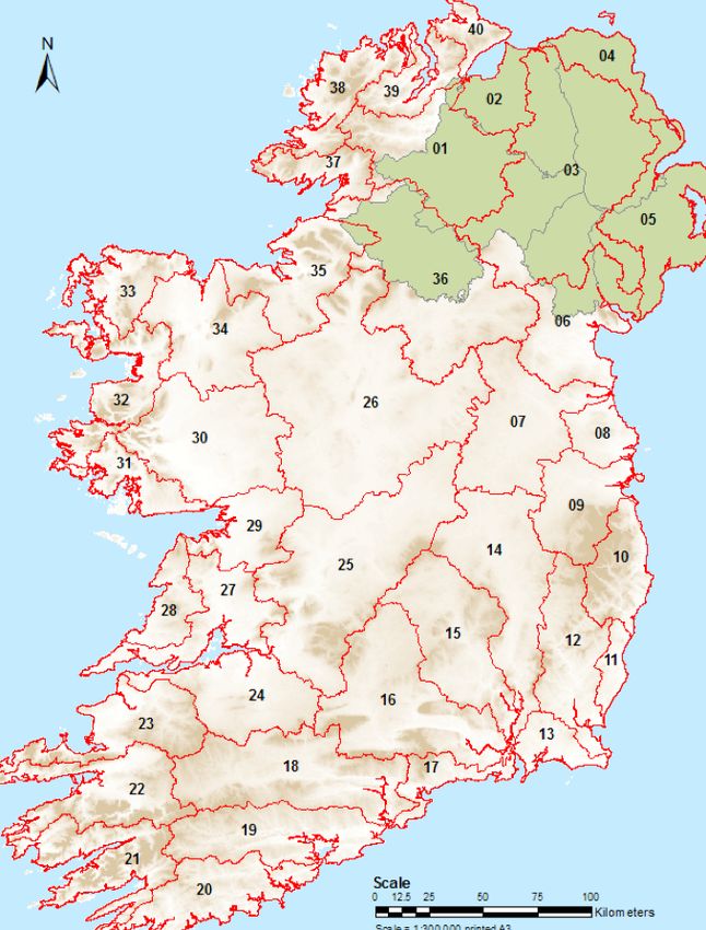
National Hydrometric Monitoring Plan 2018-2021                                   Environmental Protection Agency

In memory of...
The authors and EPA wish to dedicate this National
Hydrometric Monitoring Programme Review to the
memory of our colleague and friend Matt Morgan
(1953-2018).
Matt was born and raised in Cavan, and worked for
most of his life as a hydrometric technician, latterly
a scientific officer, in the Irish midlands, based out
of the Athlone office. Matt’s primary duties related
to the measurement of river flows and river, lake
and groundwater levels for An Foras Forbartha and
then for the Environmental Protection Agency. He
also supported the work of the Ecology Team on the
Shannon Lakes and his Enforcement colleagues, as
well as the work of the local authorities, the Office of
Public Works and Inland Fisheries.
Matt took great pride in his work and recognised
the importance of collaborating with staff in other
public authorities to deliver the best possible results.
So much so that he could have been working for any
public authority with an interest in water. He was         Matt Morgan
charming and witty, and was very much respected by         on the banks of the Bunow River, Roscrea.
all who knew him.
The legacy of the hydrometric work undertaken by
Matt, alongside his colleague Donal Quinn, will serve
Ireland well in relation to the future management of
water resources and environmental protection in the
midlands region.
Matt’s presence and contribution to the work of
the Environmental Protection Agency will be greatly
missed. May he Rest in Peace.
Matthew Craig, Manager Hydrometric and
Groundwater Programme, EPA

Environmental Protection Agency
                                                                                                       ISBN: 978-1-84095-779-2

                                                                                                                           Page 3
National Hydrometric Monitoring Programme 2018-2021                                  Environmental Protection Agency

Contents

Introduction                                                                                                     1
National Hydrometric Working Group                                                                               1
Reviewing the Hydrometric Network                                                                                1
Station Classification                                                                                           2
Rationale and approach                                                                                           3
Programme network structure                                                                                      3
Hydrological estimation in ungauged catchments                                                                   3
Configuration of the proposed National Hydrometric Monitoring Programme                                          4
Future reviews of the National Hydrometric Monitoring Programme                                                  7
Publication of Information                                                                                       7
Appendix A: International Hydrometric Review                                                                     *
Appendix B: National Hydrometric Programme Technical Review                                                      *
Appendix C: Section 64 of the Environmental Protection Agency Act                                                *
Appendix D: National Hydrometric Working Group - Terms of Reference                                              *
Appendix E: Station requirement assessment procedure                                                             *
Appendix F: Stations included in the National Hydrometric Monitoring Programme                                   *
Appendix G: National Monitoring Programmes Maps, by Hydrometric Area                                             *

*All the Appendices are separate documents

Authors: Conor Quinlan, Matthew Craig, Rebecca Quinn, Andy Fanning. The authors would also like to thank their
EPA collegaues, JBA Consulting and members of the National Hydrometric Working Group for their assistance.

                                                                                                                       Page 4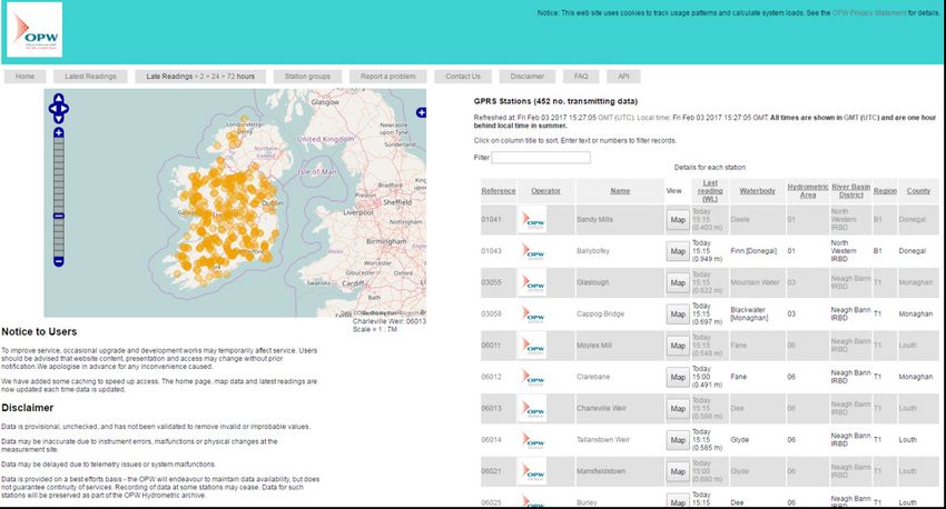
National Hydrometric Monitoring Programme 2018-2021                                      Environmental Protection Agency

Introduction                                                  National Hydrometric Working Group
                                                              Several agencies of the State and organisations are
Hydrometric programmes are a critical component of            involved in the collection, analysis and publication
water management practices internationally. Uses of           of hydrometric information in Ireland. These
hydrometric data and information include:                     organisations coordinate their hydrometric activities
■■   Informing decision making on abstraction and use;        in Ireland via the National Hydrometric Working
■■   Informing decision making for flood risk protection;     Group. Membership of the Group currently consists
                                                              of; EPA, OPW, Marine Institute, Inland Fisheries
■■   Informing emission limit values for discharge
                                                              Ireland, NPWS, ESBI, City and County Management
     consents;
                                                              Association, Waterways Ireland, Teagasc, Rivers
■■   Providing a mechanism for verification that activities   Agency Northern Ireland, Met Éireann and Irish Water.
     and development are or are not having a negative         A National Hydrometric Register is maintained by
     impact on the environment;                               the EPA and contains details of all active and inactive
■■   Informing decisions on infrastructural development       hydrometric stations maintained by members of the
     e.g. roads, urban planning, flood alleviation            National Hydrometric Working Group (Appendix D).
     schemes and small scale hydroelectric schemes;           The Group, which meets bi-annually, continues to
                                                              develop its role and plays a central part in the future
■■   Supporting the development of flow standards and
                                                              management of hydrometric data collection in Ireland.
     modelling of ungauged catchments; and
                                                              During the period of this programme, the National
■■   Informing the decision making for climate change
                                                              Hydrometric Working Group will continue to consider
     adaptation and mitigation actions in response to
                                                              strategic, operational and technical issues within its
     rising sea levels and changes in rainfall patterns.
                                                              remit. The National Hydrometric Working Group will
There has been a national hydrometric monitoring              facilitate strong governance of hydrometrics in Ireland,
programme in place in Ireland for decades to                  including; maintenance of the national hydrometric
address these requirements. A number of agencies              register, data quality standards, station classification,
of the State and organisations are involved in the            development of a national, multi-organisational
collection and analysis of hydrometric information in         approach to station installation and closure processes,
Ireland. Each of these organisations has an interest          and the adoption of new technology and software as
in hydrometric data and information for their own             appropriate.
purposes. Within this context, the EPA is given
                                                              Appendix E highlights the process for activation
a specific responsibility under Section 64 of the
                                                              and deactivation of stations within the national
Environmental Protection Agency Act to prepare “a
                                                              programme.
national programme for the collection, analysis and
publication of information on the levels, volumes and
                                                              Reviewing the Hydrometric Network
flows of water in rivers, lakes and groundwaters in
the State” (Appendix C). The Act also requires the            The EPA’s Hydrometric Review in 2010 led to twelve
EPA to review this programme every five years and             flow monitoring sites and 137 water level only
ensure that the programme is implemented. Since the           sites being dropped from the national hydrometric
Environmental Protection Agency Act was put in place          monitoring programme. In 2016, a fresh assessment
in 1992, the implementation of the Water Framework            of the adequacy and representativeness of the
Directive and the Floods Directive has brought more           surface water network was undertaken. As part of
legislative drivers on the quantitative aspects of            this review process, an international comparison of
water management and catchment management                     hydrometric data collection in Ireland, Scotland, Wales
assessments. This document sets out the actions               and New Zealand was completed by consultants
taken to arrive at the proposed national hydrometric          (Appendix A). The international review compared
monitoring network and sets out the proposed                  network configuration, network resourcing and
programme until 2021.                                         network management and governance. Results
                                                              from the review of international practice showed
                                                              that the existing hydrometric network configuration
                                                              and organisational framework has been shown to
                                                              be broadly in-line with international norms. The

                                                                                                                           Page 1
National Hydrometric Monitoring Programme 2018-2021 Environmental Protection Agency
international review also recommended areas for ■■ Stations were identified where an assessment
improvement including having processes in place for is needed to determine if flow-ratings can be
the activation and deactivation of stations within the improved that currently do not have high quality
national programme. This process has been developed flow-ratings.
as part of the review (Appendix E).
The technical review of the national network was
done using the hydrometric area as the spatial unit
for assessment (Appendix B). Hydrometric areas were
chosen as they are delineated by catchment and
provide the basis for the WFD implementation e.g.
Suir catchment or Liffey catchment. Within each
hydrometric area the existing hydrometric network
was assessed, along with an assessment of the main
pressures, and receptors including surface water
abstractions, discharges to surface water, protected
areas and hydrometric data requirements. The overall
objective of the review was to identify and assess
the suitability of the existing national hydrometric
network to fulfil the requirement of the EPA and
other stakeholders. Based on an assessment of each
Hydrometric Area, conclusions regarding the existing
network and recommendations for future have been
developed. In summary, the proposed changes to the
existing network were:
■■ The closure of eight existing EPA/LA stations (3% of
the total existing EPA/LA network);
Figure 1: Map of Hydrometric Areas in Ireland
■■ 21 suspended EPA/LA stations in Munster were
identified which should be reactivated as soon as
Station Classification
possible;
Following discussion with the National Hydrometric
■■ Two locations have been identified where new EPA/
Working Group, all stations have been assigned to
LA stations are required for long term flow-rating
one of the three sub-categories as detailed in Table 1.
development. Initially these will start as project
It is important to note that stations can be designated
stations;
in any of the three categories based on their
■■ 20 additional locations have been identified where importance to individual organisations, even if they
EPA/LA project stations should be established for are not fully rated across all flows. As such at some
a minimum of two years. Whilst less critical than strategic sites there may be a requirement for high or
the two stations in the previous bullet point, these low flow only. The rationale behind the classification
project stations initially will be used to gather data process is set out in the 2017 EPA Hydrometric Review
and fill knowledge gaps, and provide validation to documentation (Appendix B). Stations that have been
hydrological model outputs. However, depending identified for rating improvement have been flagged
on the quality of data obtained from them, there for development where technically feasible. This
is potential for some of the project stations to classification does not denote the overall data quality
become permanent stations for hydrological model at a site but rather the importance of data collection
calibration. at that site. Its main value is to provide a framework
■■ All stations were classified as either strategic, to manage the network into the future in such a way
operational or project stations. This classification that data collection is not discontinued at important
will assist with the management of the network sites without an appropriate review being undertaken.
via the National Hydrometric Working Group by
ensuring that strategic stations are not deactivated
without the group being consulted; and
Page 2National Hydrometric Monitoring Programme 2018-2021 Environmental Protection Agency
SUB- DEFINITION EXISTING NO PROPOSED
CATEGORY OF STATIONS NO. OF
STATIONS
STRATEGIC Permanent stations that are strategically important 367 367
to provide data for multiple uses and overall
provide data required for the understanding of the
hydrology of Ireland. Such stations are particularly
important for modelling and statutory reporting
requirements.
OPERATIONAL Long-term stations installed to provide data for 421 416
ongoing use such as flow at major waste water (+173 in (+173 in
treatment plants, abstractions etc. (typically Northern Northern
operated for >10 years). Ireland) Ireland)
PROJECT Temporary stations installed for a defined project 12 31
to provide data for a specific use (including
modelling). Projects may last for extended periods.
TOTALS 973 987
(800 in ROI) (814 in ROI)
Table 1: Proposed Hydrometric Station Categories
Rationale and approach for assessment. Such spot flow and temporary station
activities will provide a resource efficient and dynamic
means of providing the required range of hydrometric
Programme network structure data, from strategic, fixed, long-term locations to
The proposed national hydrometric monitoring tactical, mobile, short-term locations.
programme will consist of a network of hydrometric
stations operated by the EPA/local authorities, the Hydrological estimation in ungauged
OPW and the ESB. The network is managed within catchments
the framework of the national hydrometric areas, of
It is not possible to monitor flows everywhere.
which there are 40 (Figure 1). The stations will record
The EPA HydroTool model estimates hydrological
time series data of river flows, levels and lake levels
statistics for ungauged catchments in Ireland using
around the country. Station upgrades or new station
the collected data as a basis. The EPA will continue
requirements which were identified from the review
to maintain a publicly available hydrological model
process will be progressed during the implementation
capable of estimating flow statistics in ungauged
period of this national programme i.e. by 2021. This
catchments through the upgraded Wallingford
static network will provide a representative, long-
Hydro Solutions Qube application. The model will be
term flow and water level dataset at a national scale.
supported and refined using data obtained through
Operational requirements for licencing or WFD related
the national hydrometric monitoring programme.
work (investigative monitoring) will be accommodated
by the inclusion of a targeted spot flow measurement
programme and temporary project stations as
Configuration of the proposed
required. Locations where these operational National Hydrometric Monitoring
requirements have been tentatively identified from Programme
the review process stakeholder consultation include
The proposed National Hydrometric Monitoring
the River Brickey near Dungarvan, the Allow River
Programme comprises a subset of stations from
near Kanturk, rivers flowing into Kenmare Bay, Lough
the National Hydrometric Register. The National
Bunny in County Clare, Lough Talt in County Sligo,
Hydrometric Register is maintained by the EPA and
and several marl lakes. The outputs of the WFD
contains details of all active and inactive hydrometric
characterisation process will provide further locations
stations maintained by members of the National
Page 3National Hydrometric Monitoring Programme 2018-2021 Environmental Protection Agency
Hydrometric Working Group. The Register currently Tables 2 and 3 indicate that the planned national
contains a total of 2,072 active and inactive stations hydrometric programme is to include 559 river
(Table 2) (excluding the stations located in Northern flow or lake stations; 484 are flow-rated stations,
Ireland). Of these there will be 537 active flow- of which 346 have acceptable quality flow-ratings
rated or lake level stations included in the proposed and 138 have been flagged for rating improvement
national hydrometric programme. There will also be (where technically feasible). The remaining stations
an additional 22 new flow-rated monitoring stations. are 22 new stations (2 new permanent stations and
The EPA national hydrometric monitoring programme 20 project stations) and 53 lake level monitoring
is focused on gathering river flow and lake level data, stations. Stations flagged for rating improvement
and therefore the 253 active tidal and river level-only are maintained by the OPW, EPA/LAs and the ESB;
stations contained in the National Register have been rating improvement will be progressed where the
excluded from the national programme. The Marine station is suitable for rating improvement and as
Institute and Waterways Ireland are also developing data requirement priorities dictate. A summary of the
flow ratings for a small number of their stations. The stations within each Hydrometric Area is provided in
EPA will progress discussions with the local authorities, Appendix F and an example of a hydrometric area
the OPW, Marine Institute and Waterways Ireland map showing their locations is provided in Appendix
during the period of this plan to identify how these G.
tidal and newly flow rated stations can be brought
into the subsequent plan to supplement the existing
station network and to enable climate change impacts
to be monitored. These nascent flow rated, tidal or
river level only stations have been excluded from the
totals presented in Table 3 and Appendix F.
Table 2: Summary of stations contained in the National Hydrometric Station Register
NUMBER OF LEVEL AND LAKE LEVEL SPOT WATER TOTAL
HYDROMETRIC FLOW FLOWS LEVEL ONLY
STATIONS ONLY
TOTAL EXISTING*^ 556 119 970 427 2,072
INACTIVE 72 66 970 174 1,282
HYDROMETRIC
STATIONS
CURRENTLY*
CURRENT ACTIVE 484 53 0 253 790
HYDROMETRIC
STATIONS*^
PLANNED ACTIVE 506 53 0 253 812
HYDROMETRIC
STATIONS*
* includes currently suspended stations and excludes stations in Northern Ireland
^ The currently active stations scheduled for closure, arising from this review, are excluded
from these figures.
Page 4National Hydrometric Monitoring Programme 2018-2021 Environmental Protection Agency
Table 3: Summary of monitoring stations contained in the national hydrometric monitoring Programme
HYDROMETRIC AREA TOTAL TOTAL ADDITIONAL TOTAL STATIONS
EXISTING EXISTING PLANNED TO BE INCLUDED
FLOW- LAKE LEVEL EPA/LA IN NHMP (EPA/
RATED STATIONS STATIONS LA AND OTHER
STATIONS ORGANISATIONS)
FOYLE (01) 6 1 1 8
LOUGH FOYLE (02) 0 - -
LOUGH NEAGH AND LOWER 3 1 1 5
BANN (03)
BUSH AND NORTH EAST COAST 0 - -
(04)
BELFAST LOUGH AND EAST 0 - -
DOWN (05)
NEWRY, FANE, GLYDE AND DEE 11 0 0 11
(06)
BOYNE (07) 20 6 0 26
NANNY-DELVIN (08) 6 0 0 6
LIFFEY AND DUBLIN BAY (09) 22 0 1 23
OVOCA-VARTRY (10) 7 1 1 9
OWENAVORRAGH (11) 2 0 0 2
SLANEY AND WEXFORD HB’R 11 0 0 11
(12)
BALLYTEIGUE-BANNOW (13) 3 2 0 5
BARROW (14) 25 0 0 25
NORE (15) 18 0 0 18
SUIR (16) 30 0 0 30
COLLIGAN-MAHON (17) 3 1 0 4
BLACKWATER (MUNSTER) (18) 18 0 0 18
LEE, CORK HB’R AND YOUGHAL 19 2 0 21
BAY (19)
Page 5National Hydrometric Monitoring Programme 2018-2021 Environmental Protection Agency
BANDON-ILEN (20) 4 0 1 5
DUNMANUS-BANTRY-KENMARE 6 1 2 9
(21)
LAUNE-MINE-DINGLE BAY (22) 11 3 0 14
TRALEE BAY-FEALE (23) 7 0 1 8
SHANNON ESTUARY SOUTH (24) 22 0 0 22
LOWER SHANNON (25) 45 5 0 50
UPPER SHANNON (26) 49 9 0 58
SHANNON ESTUARY NORTH (27) 8 2 3 13
MAL BAY (28) 4 0 0 4
GALWAY BAY SOUTH EAST (29) 11 0 0 11
CORRIB (30) 22 3 0 25
GALWAY BAY NORTH (31) 3 3 0 6
ERRIFF-CLEW BAY (32) 10 1 1 12
BLACKSOD-BROADHAVEN (33) 5 1 1 7
MOY AND KILLALA BAY (34) 20 2 0 22
SLIGO BAY AND DROWSE (35) 15 3 4 22
ERNE (36) 23 6 0 29
DONEGAL BAY NORTH (37) 3 0 3 6
GWEEBARRA-SHEEPHAVEN (38) 5 0 0 5
LOUGH SWILLY (39) 6 0 1 7
DONEGAL-MOVILLE (40) 1 0 1 2
TOTAL 484 53 22 559
Note: These totals exclude stations identified for closure based on the review and are contingent on the
technical feasibility of improving flow-ratings at several existing sites.
Page 6National Hydrometric Monitoring Programme 2018-2021 Environmental Protection Agency
Future reviews of the National Maynooth has indicated that the HydroDetect climate
change monitoring network is likely to be reviewed
Hydrometric Monitoring Programme in 2018. The outputs of such a review may lead to
The national hydrometric monitoring programme the re-designation of several operational stations as
should be reviewed periodically as per Section 64 of strategic stations.
the EPA Act. During the coming years there will be
In the context of these ongoing developments, the
developments in data drivers as there is increasing
next scheduled review of the national hydrometric
awareness of the hydrological requirements to
monitoring programme should commence in 2021.
support good ecological status in surface waters
and as Irish Water progresses its investment and
Publication of Information
rationalisation programme. There are also likely to
be changes in the hydrometric networks operated by As set out above, Section 64 requires that the
other public organisations such as the OPW as Floods National Monitoring Programme provide for the
Directive related work is completed, particularly in the “publication of information on the levels, volumes
locations identified for further assessment under the and flows of water in rivers, lakes and groundwaters
CFRAMs work. in the State”. To this end, in conjunction with the
other hydrometric monitoring bodies, the EPA has put
The OPW and Marine Institute monitor several tidal
in place the HydroNet website (Figure 2). The website
locations and it may be advantageous to include these
contains all active and inactive (historic) hydrometric
stations in any subsequent review under a climate
stations contained in the national hydrometric register
change impact monitoring heading.
including EPA/LA, OPW, ESB, Marine Institute,
The EPA operates a network of groundwater level and Waterways Ireland stations. The HydroNet site
monitoring stations to support WFD implementation. contains both access to surface water level and
These stations were excluded from the hydrometric water flow volume data and groundwater level data.
review as they are being assessed as part of an The website can be accessed at http://www.epa.
ongoing WFD Monitoring review. The Geological ie/hydronet. The site does not provide access to all
Survey of Ireland have also commenced a turlough hydrometric data but provides links to hydrometric
monitoring project which may result in the data sets for stations operated by external agencies
establishment of 20 or so turlough level monitoring including the OPW via links contained on the station
stations. The EPA and Geological Survey of Ireland information pages. The OPW operates its own site
stations may be included in future hydrometric http://www.waterlevel.ie (Figure 3) which can be
reviews to provide a holistic and joined-up assessment accessed via HydroNet.
of surface water and groundwater hydrometric
monitoring in Ireland. Dr. Conor Murphy of NUI
Figure 2: HydroNet
Page 7National Hydrometric Monitoring Programme 2018-2021 Environmental Protection Agency
Figure 3: Waterlevel.ie
Page 8National Hydrometric Monitoring Programme 2018-2021 Environmental Protection Agency
AN GHNÍOMHAIREACHT UM CHAOMHNÚ Monatóireacht, Anailís agus Tuairisciú ar an
COMHSHAOIL gComhshaol
■■ Monatóireacht a dhéanamh ar cháilíocht an aeir agus Treoir an AE
Tá an Ghníomhaireacht um Chaomhnú Comhshaoil (GCC) freagrach
maidir le hAer Glan don Eoraip (CAFÉ) a chur chun feidhme.
as an gcomhshaol a chaomhnú agus a fheabhsú mar shócmhainn
luachmhar do mhuintir na hÉireann. Táimid tiomanta do dhaoine agus ■■ Tuairisciú neamhspleách le cabhrú le cinnteoireacht an rialtais
don chomhshaol a chosaint ó éifeachtaí díobhálacha na radaíochta náisiúnta agus na n-údarás áitiúil (m.sh. tuairisciú tréimhsiúil ar
agus an truaillithe. staid Chomhshaol na hÉireann agus Tuarascálacha ar Tháscairí).
Is féidir obair na Gníomhaireachta a roinnt ina trí Rialú Astaíochtaí na nGás Ceaptha Teasa in Éirinn
phríomhréimse: ■■ Fardail agus réamh-mheastacháin na hÉireann maidir le gáis
cheaptha teasa a ullmhú.
Rialú: Déanaimid córais éifeachtacha rialaithe agus comhlíonta
■■ An Treoir maidir le Trádáil Astaíochtaí a chur chun feidhme i
comhshaoil a chur i bhfeidhm chun torthaí maithe comhshaoil a
gcomhair breis agus 100 de na táirgeoirí dé-ocsaíde carbóin is mó
sholáthar agus chun díriú orthu siúd nach gcloíonn leis na córais sin. in Éirinn.
Eolas: Soláthraímid sonraí, faisnéis agus measúnú comhshaoil atá ar
ardchaighdeán, spriocdhírithe agus tráthúil chun bonn eolais a chur
Taighde agus Forbairt Comhshaoil
faoin gcinnteoireacht ar gach leibhéal. ■■ Taighde comhshaoil a chistiú chun brúnna a shainaithint, bonn
eolais a chur faoi bheartais, agus réitigh a sholáthar i réimsí na
Tacaíocht: Bímid ag saothrú i gcomhar le grúpaí eile chun tacú le haeráide, an uisce agus na hinbhuanaitheachta.
comhshaol atá glan, táirgiúil agus cosanta go maith, agus le hiompar
a chuirfidh le comhshaol inbhuanaithe. Measúnacht Straitéiseach Timpeallachta
■■ Measúnacht a dhéanamh ar thionchar pleananna agus clár
ÁR BHFREAGRACHTAÍ beartaithe ar an gcomhshaol in Éirinn (m.sh. mórphleananna
forbartha).
Ceadúnú
Cosaint Raideolaíoch
Déanaimid na gníomhaíochtaí seo a leanas a rialú ionas nach
ndéanann siad dochar do shláinte an phobail ná don chomhshaol: ■■ Monatóireacht a dhéanamh ar leibhéil radaíochta, measúnacht
a dhéanamh ar nochtadh mhuintir na hÉireann don radaíocht
■■ saoráidí dramhaíola (m.sh. láithreáin líonta talún, loisceoirí,
ianúcháin.
stáisiúin aistrithe dramhaíola);
■■ Cabhrú le pleananna náisiúnta a fhorbairt le haghaidh éigeandálaí
■■ gníomhaíochtaí tionsclaíocha ar scála mór (m.sh. déantúsaíocht
ag eascairt as taismí núicléacha.
cógaisíochta, déantúsaíocht stroighne, stáisiúin chumhachta);
■■ Monatóireacht a dhéanamh ar fhorbairtí thar lear a bhaineann le
■■ an diantalmhaíocht (m.sh. muca, éanlaith);
saoráidí núicléacha agus leis an tsábháilteacht raideolaíochta.
■■ úsáid shrianta agus scaoileadh rialaithe Orgánach Géinm-
■■ Sainseirbhísí cosanta ar an radaíocht a sholáthar, nó maoirsiú a
hodhnaithe (OGM);
dhéanamh ar sholáthar na seirbhísí sin.
■■ foinsí radaíochta ianúcháin (m.sh. trealamh x-gha agus radaiteiripe,
foinsí tionsclaíocha); Treoir, Faisnéis Inrochtana agus Oideachas
■■ áiseanna móra stórála peitril; ■■ Comhairle agus treoir a chur ar fáil d’earnáil na tionsclaíochta agus
■■ scardadh dramhuisce; don phobal maidir le hábhair a bhaineann le caomhnú an chom-
■■ gníomhaíochtaí dumpála ar farraige. hshaoil agus leis an gcosaint raideolaíoch.
■■ Faisnéis thráthúil ar an gcomhshaol ar a bhfuil fáil éasca a chur
Forfheidhmiú Náisiúnta i leith Cúrsaí Comhshaoil ar fáil chun rannpháirtíocht an phobail a spreagadh sa chin-
nteoireacht i ndáil leis an gcomhshaol (m.sh. Timpeall an Tí,
■■ Clár náisiúnta iniúchtaí agus cigireachtaí a dhéanamh gach bliain ar
léarscáileanna radóin).
shaoráidí a bhfuil ceadúnas ón nGníomhaireacht acu.
■■ Comhairle a chur ar fáil don Rialtas maidir le hábhair a bhaineann
■■ Maoirseacht a dhéanamh ar fhreagrachtaí cosanta comhshaoil na
leis an tsábháilteacht raideolaíoch agus le cúrsaí práinnfhreagartha.
n-údarás áitiúil.
■■ Plean Náisiúnta Bainistíochta Dramhaíola Guaisí a fhorbairt chun
■■ Caighdeán an uisce óil, arna sholáthar ag soláthraithe uisce phoiblí,
dramhaíl ghuaiseach a chosc agus a bhainistiú.
a mhaoirsiú.
■■ Obair le húdaráis áitiúla agus le gníomhaireachtaí eile chun dul Múscailt Feasachta agus Athrú Iompraíochta
i ngleic le coireanna comhshaoil trí chomhordú a dhéanamh ar
líonra forfheidhmiúcháin náisiúnta, trí dhíriú ar chiontóirí, agus trí
■■ Feasacht chomhshaoil níos fearr a ghiniúint agus dul i bhfeidhm ar
mhaoirsiú a dhéanamh ar leasúchán. athrú iompraíochta dearfach trí thacú le gnóthais, le pobail agus le
teaghlaigh a bheith níos éifeachtúla ar acmhainní.
■■ Cur i bhfeidhm rialachán ar nós na Rialachán um Dhramh-
threalamh Leictreach agus Leictreonach (DTLL), um Shrian ar
■■ Tástáil le haghaidh radóin a chur chun cinn i dtithe agus in ionaid
Shubstaintí Guaiseacha agus na Rialachán um rialú ar shubstaintí a oibre, agus gníomhartha leasúcháin a spreagadh nuair is gá.
ídíonn an ciseal ózóin.
Bainistíocht agus struchtúr na Gníomhaireachta um
■■ An dlí a chur orthu siúd a bhriseann dlí an chomhshaoil agus a
Chaomhnú Comhshaoil
dhéanann dochar don chomhshaol.
Tá an ghníomhaíocht á bainistiú ag Bord lánaimseartha, ar a bhfuil
Bainistíocht Uisce Ard-Stiúrthóir agus cúigear Stiúrthóirí. Déantar an obair ar fud cúig
■■ Monatóireacht agus tuairisciú a dhéanamh ar cháilíocht aibhnea- cinn d’Oifigí:
cha, lochanna, uiscí idirchriosacha agus cósta na hÉireann, agus ■■ An Oifig um Inmharthanacht Comhshaoil
screamhuiscí; leibhéil uisce agus sruthanna aibhneacha a thomhas. ■■ An Oifig Forfheidhmithe i leith cúrsaí Comhshaoil
■■ Comhordú náisiúnta agus maoirsiú a dhéanamh ar an gCreat- ■■ An Oifig um Fianaise is Measúnú
Treoir Uisce.
■■ Oifig um Chosaint Radaíochta agus Monatóireachta Comhshaoil
■■ Monatóireacht agus tuairisciú a dhéanamh ar Cháilíocht an Uisce
Snámha.
■■ An Oifig Cumarsáide agus Seirbhísí Corparáideacha
Tá Coiste Comhairleach ag an nGníomhaireacht le cabhrú léi. Tá
dáréag comhaltaí air agus tagann siad le chéile go rialta le plé a
dhéanamh ar ábhair imní agus le comhairle a chur ar an mBord.
Page 9National Hydrometric Monitoring Programme
2018-2021You can also read