NEW TRANSNORDESTINA RAILWAY AND SPACE ORGANIZATION - Redalyc
←
→
Page content transcription
If your browser does not render page correctly, please read the page content below
Mercator - Revista de Geografia da UFC
                                                            ISSN: 1984-2201
                                                            mercator@ufc.br
                                                            Universidade Federal do Ceará
                                                            Brasil

NEW TRANSNORDESTINA RAILWAY
AND SPACE ORGANIZATION
BIACHI, Ana Paula Theodoro; MACEDO, Fernando Cezar
NEW TRANSNORDESTINA RAILWAY AND SPACE ORGANIZATION
Mercator - Revista de Geografia da UFC, vol. 17, no. 4, 2018
Universidade Federal do Ceará, Brasil
Available in: http://www.redalyc.org/articulo.oa?id=273654905001

                                PDF generated from XML Redalyc JATS4R
                   Project academic non-profit, developed under the open access initiative
Artigos
NEW TRANSNORDESTINA
RAILWAY AND SPACE
ORGANIZATION
Ana Paula Theodoro BIACHI apbiachi@gmail.com
UNICAMP - Cidade Universitária Zeferino Vaz, Brasil
Fernando Cezar MACEDO
Abstract: is text analyses the socioeconomic and territorial impacts arising from the
Nova Transnordestina railway construction in the Ceará, Piauí and Pernambuco states.
e hypothesis is that the investments in its construction have as main purpose to
improve agricultural and mineral exportations, despite possible externalities over the
region of its influence which covers not only the states where it is being built but also
the region of Matopiba. For these reason, this text highlights the socio-environmental
problems that arise from the project and the impacts on communities affected by its
route. Methodologically, the text is based on bibliographical survey, documents related
to the projects, journalistic information and interviews. eoretically, it articulates
the socio spatial formation concept with the pattern of capital reproduction concept,
adapting them to studies of underdeveloped and dependent formations, such as the
Brazilian.
Keywords: Nova Transnordestina Railway, Regional Development, Infrastructure,
Territory.
Resumo: ferrovia nova transnordestina e organização espacial
Este texto faz uma análise socioeconômica e territorial dos investimentos da ferrovia
Mercator - Revista de Geografia da UFC, Nova Transnordestina que corta parte dos estados do Ceará, Piauí e Pernambuco. A
vol. 17, no. 4, 2018 hipótese é de que esta ferrovia tem como objetivo principal atender as exportações
agrícolas e minerais, apesar de possíveis externalidades positivas sobre a região de sua
Universidade Federal do Ceará, Brasil
influência que abrange não apenas os estados cortados por ela mas, também, a região do
Matopiba. Por isso, este texto destaca os problemas socioambientais que decorrem do
Redalyc: http://www.redalyc.org/ projeto e os impactos sobre comunidades atingidas por seu traçado. Metodologicamente,
articulo.oa?id=273654905001 o texto foi construído a partir de levantamento bibliográfico, documentos relativos
aos projetos, informações jornalísticas e entrevistas. Teoricamente, parte do conceito
de formação socioespacial e articula-o com o conceito de padrão de reprodução do
capital adaptando-os para estudos de formações subdesenvolvidas e dependentes, como
a brasileira.
Palavras-chave: Ferrovia Nova Transnordestina, Desenvolvimento Regional,
Infraestrutura, Território.
Resumen: NOVA TRANSNORDESTINA FERROCARRIL Y LA
ORGANIZACIÓN ESPACIAL
Este texto es un análisis socioeconómico y territorial de las inversiones en la Nova
Transnordestina ferrocarril que corta parte de los estados de Ceará, Piauí y Pernambuco.
La hipótesis es que este ferrocarril tiene como principal objetivo satisfacer las
exportaciones agrícolas y minerales, a pesar de los posibles efectos externos positivos
en la región de influencia, que abarca no sólo los estados cortados por ella, sino
también la región de MatopibaPor lo tanto, este documento pone de relieve los
problemas sociales y ambientales que surgen del proyecto y los impactos sobre las
comunidades afectadas por su trazado. Metodológicamente, el texto se construye a partir
de los documentos bibliográficos relativos a los proyectos, información periodística y
entrevistas. Teóricamente, parte del concepto de formación socioespacial y lo articula
con el concepto de patrón de reproducción del capital adaptándolos a estudios de
formaciones subdesarrolladas y dependientes, como la brasileña.
PDF generated from XML Redalyc JATS4R
Project academic non-profit, developed under the open access initiativeAna Paula eodoro BIACHI, et al. NEW TRANSNORDESTINA RAILWAY AND SPACE ORGANIZATION
Palabras clave: Nova Transnordestina Ferrocarril, Desarrollo Regional, Infraestructura,
Territorio.
Introduction
e objective of this text is to make a socioeconomic and territorial
analysis of the investments in the construction of the New
Transnordestina railway, a project that began effectively in 2006, when
the first works were carried out in the Missão Velha / CE to Salgueiro / PE
section. ese investments are intended to complement the 4.3 thousand
km of the railway network in the Northeast, privatized in 1997. It would
thus retake the historical and secular discourse of a railroad connection
in the interior of the Northeast that dates from the end of the eighteenth
century, as pointed out by authors like Pinto (1947) and Camelo Filho
(2011).
Although the official discourse maintains the pioneering idea of
integration that, through the railway, sought to articulate the economic
activities and the different regional spaces of the Northeast, the new
railroad plays a less ambitious role and is a direct response to the
international market pressures that deepen the Brazilian model of
dependent underdevelopment and is linked to the production of
commodities with a low added value. is reinforces the need to adapt the
territory to the demands of the pattern of reproduction of the dominant
capital in the Brazilian economy since the end of the twentieth century,
increasingly linked to agricultural and mineral activities for export that
require major infrastructure works, especially transport - such as the
railroad under discussion herein - in order to dispose of its production
located in the interior of the country. is is the hypothesis that guides
this work.
e New Transnordestina starts in the municipality of Eliseu Martins /
PI and will reach the ports of Suape / PE and Pecém / CE, which will
be interconnected from a central junction in Salgueiro (PE). ere will
be 1,728 km crossing 81 municipalities in the states of Piauí, Ceará and
Pernambuco, with an estimated cost of R$ 11.3 billion. e project is
therefore linked to investments in the modernization and expansion of
these ports and, on the other hand, to the expansion of the mineral and
agricultural frontier of the cerrado, especially in the Matopiba region,
which would allow the railroad to transport loads of up to 30 million
tons / year of agricultural and mineral products for export from its area
of influence, according to estimates from official documents and the
operator Nova Transnordestina Logística SA - TLSA.
is text is divided into five parts, beginning with this brief
presentation. is is followed by a discussion of the relationship between
infrastructure and spatial organization, with particular emphasis on the
role that the investments destined to diversification and the expansion of
the modes of transport undertake in the present phase of accumulation
of the Brazilian economy, strongly centered on the production of
commodities for the external market. is role is not limited just to
PDF generated from XML Redalyc JATS4R
Project academic non-profit, developed under the open access initiativeMercator - Revista de Geografia da UFC, 2018, 17(4), ISSN: 1984-2201
the expansion of export capacity and the reduction of the “Brazil cost”
as traditionally presented, but also, because of the impact they have on
the spatial organization of the country’s regions and subregions. e
next topic presents the features of the New Transnordestina project
and is subdivided into a brief territorial and productive analysis of three
States through which it passes. e fourth topic summarizes the main
possibilities and the main problems faced in the execution of the project,
highlighting the socioeconomic and spatial impacts raised to date. Finally,
the text concludes with the final considerations.
is work is anchored in information obtained from public and private
agencies, such as the General Comptroller of the Union (CGU), the
National Association of Railways (ANTF), the National Department
of Transport Infrastructure (DNIT), the Ministry of Transport (MT),
the National Confederation of Agriculture (CNA), VALEC Engenharia,
Construções e Ferrovias S.A., the National Confederation of Transport
(CNT) and the Institute of Applied Economic Research (IPEA). In some
of these institutions, in addition to the documents collected, interviews
were conducted with some of their representatives.
Specifically, for the state of Pernambuco, field research was carried
out with the main objective of understanding the articulation of the
expansion of the agricultural frontier in the north-eastern Cerrado with
the decision regarding investments in the construction of the railroad.
Interviews were conducted with professionals from selected sectors in a
strategic way, to obtain different points of view about the objectives and
feasibility of the project, as well as more accurate information concerning
this project in the state. To this end, representatives of the following
institutions were selected: (i) public sector - Pernambuco Economic
Development Agency (Addiper), Secretariat of Economic Development
(SDEC) and the Governor Eraldo Gueiros Industrial Port Complex
(Suape); (ii) private sector - Economic Consulting and Planning (Ceplan)
and (iii) academia - Federal University of Pernambuco (UFPE).
Pattern of capital reproduction, external insertion in
commodities, infrastructure and territory in Brazil in the
twenty-first century
In order for this text to meet its general objective, it is essential that
the discussion be based on an analysis of the relationship between
infrastructure and spatial organization, with particular emphasis on the
role that investments in the diversification and expansion of transport
modes play in the current phase of accumulation of the Brazilian
economy, strongly focused on the production of commodities for the
external market. us, throughout this study, the aim is to demonstrate
that such investments are not only limited to the expansion of the export
capacity and the reduction of the “Brazil cost” as traditionally presented,
but they become a fundamental tool for changes in the organization of
the regions and subregions of the country.
PDF generated from XML Redalyc JATS4R
Project academic non-profit, developed under the open access initiativeAna Paula eodoro BIACHI, et al. NEW TRANSNORDESTINA RAILWAY AND SPACE ORGANIZATION
Pattern of reproduction, underdevelopment and
dependence
Between 1930 and 1980, Brazil had an urban-industrial economy that
transformed it into the most complex productive structure among the
Latin American countries. is pattern of reproduction, which mirrored
the emergence of more advanced productive forces in the interior of
its underdeveloped and dependent economy, was characterized by the
strong dynamism of the internal market that would reorganize the use
and occupation of its territory in a manner that was very distinct from the
primary export period prevalent prior to 1930.
Of the former regional archipelagos that were directly linked to the
external market, with a port city as a node of a dendritic network
whose hinterland was organized around it, the industrialization of the
country promoted greater integration of the territory by articulating
the internal market; an integration that was expressed in the increase
of flows of goods, services, people, information and capital through
an urban network that lost its regional character and subsequently
took on a national and international projection, captained by the
city of São Paulo that would gain metropolitan dimensions. In this
process, the infrastructure financed by the national State, especially
telecommunication and transport networks (mainly linked to the road
system), as well as intra-urban investments, ensured, on the one hand,
commercial circulation and the expansion of consumption and, on the
other hand, the reproduction of the workforce, which demanded an effort
to expand urban facilities. e spatial organization that emerged at that
time was strongly metropolitan and concentrated in the Southeast of
Brazil, which received the main flows of internal migrations, which were
mostly rural-urban.
e crisis of the pattern of urban-industrial reproduction in the 1980s
and the restructuring of global capitalism in the last quarter of the
twentieth century changed the role of the country (and of Latin America)
in the international division of labor. e manufacturing industry lost
momentum and the process of de-industrialization underway in Brazil
and in the region began, but it would become more evident in the
twenty-first century. In contrast, agricultural and mineral activities and
the segments of the manufacturing industry linked to them became more
dynamic and would be the ones with which the country would increase
its participation in foreign trade, a clear demonstration of its role in
the international division of labor. e participation of agricultural and
mineral commodities in the export agenda did not only increase with
the relative fall in the participation of industrial products, there was
also a rise in investments directed to these sectors, such as the Direct
Foreign Investment (DFI). is was especially the cases aer 2003, when
the increase in global demand driven by the “China-effect” increased
the internal dynamism of these activities, consolidating the new pattern
of reproduction in the country that Osório (2012a and 2012b) calls
the “exportation pattern of productive specialization” (post-1980) as
PDF generated from XML Redalyc JATS4R
Project academic non-profit, developed under the open access initiativeMercator - Revista de Geografia da UFC, 2018, 17(4), ISSN: 1984-2201
opposed to the “industrial pattern” that dominated the previous phase
(1930-1980).
As described by this author, “each pattern of capital reproduction
presents specificities as to the use made of geographical space. Capital
intervenes in the territory in different ways, according to the particular
needs that its metamorphosis demands” (OSORIO, 2012a, p. 73). e
notion of the pattern of capital reproduction enables a methodological
understanding of “how capital reproduces itself in specific historical
periods and in certain geoterritorial spaces, both in the center and in the
semi-periphery and periphery, or in regions within each one” (OSORIO,
2012a, p. 40).
From the quotations above, it is assumed that it is only possible
to analyze a socio-spatial organization within the general process of
accumulation in the world, articulated in multiple scales and from
the cycle of capital within the prevailing reproduction pattern at
each point in time. at is, at each historical stage, there is a way
of organizing production and circulation that redefines the use and
occupation of territories, within an international division of labor that
specializes and integrates national and local economies into a world
economic system. erefore, the predominance of a pattern of capital
reproduction corresponds to a pattern of spatial organization whose form
can only be grasped at more concrete levels of analysis that make it
possible to reveal how the general movement of capital manifests itself
effectively in the territory by altering or influencing the (re)location of
productive activities, patterns of urbanization, migratory movements,
policies (macroeconomic, regional, urban, etc.), the labor market and
infrastructure investments, among others.
Each country, region or local area inserted in the general accumulation
process is forced to adapt to the demands of the dominant pattern of
reproduction that is peculiar to it within the more general movement
of capital, especially in underdeveloped and dependent countries. us,
a territorial (national and international) division of labor is markedly
heterogeneous in which the parties are interrelated. In the transition
from one pattern to another, the regional and urban dynamics in the
countries are redefined. e spatial forms that emerge in each place
are specific to their socioeconomic structures and move according to
the process of reproduction of capital in each specific conjuncture.
For Sormani (1977), from the general proposition that every human
practice develops on a given space, whose qualitative and quantitative
characteristics condition it, it is necessary to insist on the fact that this
space takes on specific forms, dispositions and structures in each case that
respond to the nature and historical specificity of the types of prevailing
organization that order and legitimize these practices. Consequently, the
study of the forms of the spatial organization of society, whether relatively
spontaneous or voluntarily imposed, must necessarily be linked to the
concrete conditions of the process of development of the dominant mode
of production within a social formation. e changes that take place will
determine the new conditions of use and conformation of the space, the
PDF generated from XML Redalyc JATS4R
Project academic non-profit, developed under the open access initiativeAna Paula eodoro BIACHI, et al. NEW TRANSNORDESTINA RAILWAY AND SPACE ORGANIZATION
role of each of the settlements, the way they interconnect and, finally,
the internal structure of the different regions and the regional system as
a whole (SORMANI, 1977, p. 160).
It is important to make it clear that the combination of natural and
constructed elements determines the spatial organization that varies in
each historical moment, moving in accordance with the socioeconomic
transformations of society and with the interests that materialize in
economic policy. Like Corrêa (1986), we consider here the terms
territorial structure, spatial configuration, spatial formation, spatial
arrangement, geographic space, socially constructed space or simply
space as synonyms. It is important to understand that this organization
accumulates inherited forms from the past, which makes it a durable,
although constantly changing, fact. It is not only a reflection of society
but an indispensable basis for its reproduction, which means that the
present conditions are determinant for future conditions of reproduction
of society, as the author points out. is puts social groups and the
various fractions of capital that compete among themselves, within a same
country in constant conflict over the territorial order that best guarantees
their reproductions. In a federative country, such as Brazil, this process
means the escalation of the regional dispute over access to public funds
and the dispute between subnational federative entities for the location of
capital and its investments and for the use and occupation of the territory.
It also means that spatial organization is largely a result of
the macroeconomic policies and interests that define the country’s
articulations with the international economy, and hence of the class
struggle established in each territory and marked by the specificities of
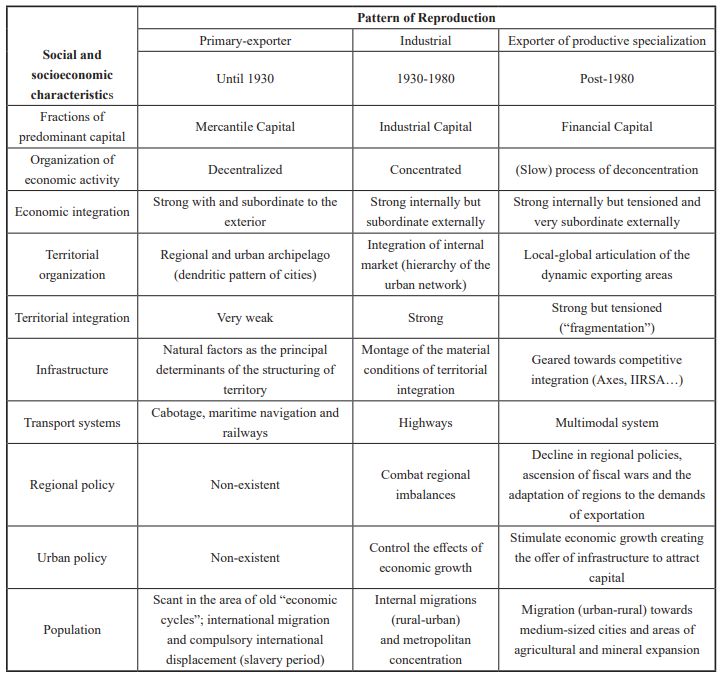
each conjuncture. Table 1, adapted from Macedo (2010), synthesizes the
processes of organization of the Brazilian territory in the three patterns
of reproduction of capital described by Osório.
PDF generated from XML Redalyc JATS4R
Project academic non-profit, developed under the open access initiativeMercator - Revista de Geografia da UFC, 2018, 17(4), ISSN: 1984-2201
Chart 1 - Brazil: patterns of capital reproduction and spatial organization
Adapted from Macedo (2010)
Despite their specificities, the different patterns of reproduction
that emerge historically in Latin America, and in Brazil in particular,
have a characteristic that has remained constant over time and has
decisively influenced their spatial organization since the colonial past:
the adaptation of the territory from external decision-making centers.
is means that territory exists not to serve a nation project, but to
meet the demands of primitive accumulation imposed by the colonial
statute (at the beginning of its formation) and by the subsequent
expanded reproduction of capital, within the framework of imperialism.
at is why in each dominant pattern of reproduction there will be
investment requirements for the (re)organization of the territory and
specific territorial policies for this.
However, although subordinated to the general movement of capital,
it is necessary to differentiate the specificities that mark the different
socio-spatial formations, aer all, “the search for tendencies and
general traits should not suppose the loss of capacity to account for
particularities” (OSORIO, 2012, p. 80). e new dominant pattern of
PDF generated from XML Redalyc JATS4R
Project academic non-profit, developed under the open access initiativeAna Paula eodoro BIACHI, et al. NEW TRANSNORDESTINA RAILWAY AND SPACE ORGANIZATION
reproduction in post-1980s Brazil, promoting the more intensive use
of natural resources, directed agribusiness and mining activities to areas
further from the industrial core (the Southeast, more specifically the state
of São Paulo) where land and mineral resources were available, such as
the Center-West region, the southeastern state of Pará and the Matopiba
region.
Agricultural and mineral productions for export extended the
interiorization of the country and caused alterations in the urbanization,
which became more extensive in the territory. In the same way, there
was a change in the migratory flows with the new dynamic areas
growing in attractiveness. ese areas established true local-global links,
oen articulating more with the external market than with the internal
one, mediated by the large global players that have become decisive in
their spatial organization, especially due to the pressures they exert for
the construction of infrastructures that allow agricultural and mineral
products to connect with international markets. According to Macedo
(2010), summarizing Table 1, this is the new pattern of territorial
organization that manifests itself in Brazil at the beginning of the
twentieth century: (slow) processes of economic and demographic
deconcentration; stronger local-global articulation in the areas inserted
in the currents of external trade; potential fragmentation of territory;
growth of medium-sized cities beyond the traditional metropolitan
areas, reproducing the old urban problems; new territorialities emerging
in the areas of agricultural and mineral expansion; lower rates of
rural-urban migration and the growth of urban-urban migration; the
predominance of large corporations in the structuring of regional and
urban spaces; establishment of infrastructures to increase the external
productive integration; and, creating regional and urban policies directed
at increasing the competitive integration in the country (MACEDO,
2010, p. 67-68).
It is within this general framework of transformation of the Brazilian
economy and its territorial dynamics that the investments in transport
infrastructure in post-2005 Brazil will be analyzed, among which the New
Transnordestina Railroad has stood out.
Infrastructure and territory
For the reasons given above, infrastructural investments have gained
prominence in the debate and formulation of economic policies in this
century. Examples are the actions of the federal government through
the National Logistics and Transport Program - PNLT (dated 2007),
the Growth Acceleration Program - PAC 1 (2007-2010), PAC 2
(2011-2014), the Integrated Program of Logistics - PIL (2011-2014)
and PIL 2 (2015-2018), in addition to the Initiative for Integration
of South American Regional Infrastructure (IIRSA) and the National
Integration and Development Axes (ENID) in the second Fernando
Henrique Cardoso government (1999-2002). is latter synthesized well
the concept of the use of the territory that guides all these initiatives: the
PDF generated from XML Redalyc JATS4R
Project academic non-profit, developed under the open access initiativeMercator - Revista de Geografia da UFC, 2018, 17(4), ISSN: 1984-2201
identification of the dynamic foci of the economy and the constitution
of a multimodal network to transfer regionalized productions to the
external market.
Despite the effective results of these initiatives, which will not be
analyzed here, the relevant fact is the recognition that the country’s
type of foreign trade insertion, based on low-value products and large
volumes for export, puts pressure on the public sector and private
agents to increase investments to accelerate and reduce the cost of
their stocking, storage and disposal, favoring the capital circulation
phase. A quick reading of the official documents of the aforementioned
programs or comparable private sector entities, such as those of the CNT
(2014 and 2015), reveals the priority given to investments in transport
infrastructure in the current pattern of capital reproduction in Brazil.
is is because such investments increase the competitiveness of the
economy, allow the efficient flow of mineral and grain production, and
reduce logistical costs for all sectors, reducing the time of capital turnover.
Given the characteristics of this infrastructure, especially the long term
maturity of its investments and the high capital / product ratio, which
requires a great mobilization of financial resources, there is a temporal
mismatch between the increase in productive capacity - located further
and further away from the center of greatest consumption of final goods
and the highest demand for intermediate goods in the country - and an
improvement in the conditions for disposing of production, especially for
the foreign market. Exports from the new producing areas are still very
dependent on the ports of the Southeast and South regions as shown in
Chart 1 which takes as an example some agricultural commodities.
Although manifest in all sectors of the economy, this problem seems
to be more visible for the products that represent the core of Brazilian
exports, because of their location in the interior and in areas with
little economic density. e combination of low value-added, high
production volumes and the long distances from the areas producing
these commodities to the outflow routes for export and to the largest
Brazilian urban centers requires real adaptations of these dynamic
economic spaces to promote their exports.
An example illustrates this. Despite the increase in the participation of
the Central-West region in grain production in Brazil, it can be observed
that the ports of the Southeast and South, more specifically the ports of
Santos / SP, Paranaguá / PR, Vitória / ES and São Francisco do Sul /
SC continue to participate heavily in the export of the main products
exported by the State of Mato Grosso (Figure 1), the main Brazilian
producer of soybeans, soybean meal and corn, important products of the
country’s export agenda. Between 2000 and 2014, the State’s exports of
the three products (in tons) rose an average annual rate of 14.6%. e
production of soybeans and corn increased 11.8% between 2000 and
2013. For Brazil, during the same periods, this growth was 10.5% pa and
7.3% pa respectively. ese figures indicate the role of these commodities
in the country’s export base and the importance of the Center-West for
the trade balances.
PDF generated from XML Redalyc JATS4R
Project academic non-profit, developed under the open access initiativeAna Paula eodoro BIACHI, et al. NEW TRANSNORDESTINA RAILWAY AND SPACE ORGANIZATION
Figure 1
Participation of South and Southeast ports in the flow of soy,
soybean meal and maize from Mato Grosso - Years 2000-2014 (in%)
Ministry of Development, Industry and Foreign Trade (MDIC) Elaboration CEDE / IE / UNICAMP.
Figure 1 indicates a greater distance between the place of production
and its flow to the exterior. is movement requires the federal
government, producers and freight operators both to expand and
diversify transportation infrastructure, since production in Brazil
continues to be transported mainly by trucks, as alternatives to the exit
of the product to the north of the country or other ports that may
serve the production of the Brazilian Cerrado, such as that of Itaqui /
MA or those of Suape / PE and Pecém / CE which, through the New
Transnordestina, may be alternatives for the Matopiba region’s exports,
as will be highlighted below.
e New Transnordestina
is section analyzes the railway line in order to evaluate the potential
of investment in logistics as a determinant of economic dynamism and
possible productive and territorial restructuring. To this end, it is taken
into account that as a private enterprise is involved, it is the economic
density of its area of influence that determines its viability, despite its
ultimate goal being to carry the grain and mineral production from
the Northeastern Cerrado and part of the Center-west. erefore, this
analysis aims to relate the possible points of multimodal links and their
respective areas of influence, highlighting their economic characteristics.
General characterization of the railway: history, initial design and
specificities
A regional project, linking the ports of Pecém / CE and Suape / PE to the
city of Eliseu Martins / PI in the northeastern Cerrado, the construction
of the New Transnordestina Railroad, part of the PAC, is the structural
PDF generated from XML Redalyc JATS4R
Project academic non-profit, developed under the open access initiativeMercator - Revista de Geografia da UFC, 2018, 17(4), ISSN: 1984-2201
project that best demonstrates the integration of the market investment
in infrastructure and logistics in the Northeast. In addition to its more
general objectives of transporting grain and ore production from the
Cerrado, the project is intended to complement the railway network
in the region; its intermodal integration with several highways and the
São Francisco waterway, in Petrolina / PE; the articulation of several
agro-industrial regions with large ports, and consequently, the significant
reduction of the distance by railway to the main cargo areas of the
Northeast.
With a predicted initial investment of R$ 11.3 billion and completion
estimated initially for 2010, the project contemplates the construction
of 650 km of new railway track between the cities of Missão Velha/CE
– Salgueiro/PE – Trindade/PE – Eliseu Martins/PI. e engineering
projects, environmental licenses, earthworks and drainage were the
responsibility of the then Concessionaire Companhia Ferroviária do
Nordeste - CFN, with the expropriations being the responsibility of the
National Department of Transport Infrastructure - DNIT.
During the first year of PAC 1, an executive group was created
between the Federal Government, State Governments (PE/CE/PI)
and the Concessionaire - CFN to monitor the project. Cooperation
agreements were signed between the DNIT / MT and the state
governments to accelerate the process of expropriation, and for the
Brazilian Institute of Environment and Renewable Natural Resources /
Ministry of Environment - IBAMA / MMA to accelerate the process of
environmental licensing. However, successive delays in the execution of
the works throughout period 2, led to the termination of the contract
between the concessionaire and the construction company in 2013
and the signing of a new concession agreement on January 22, 2014.
e concessionaire responsible for the works is Nova Transnordestina
Logística SA - TLSA, a subsidiary of the Companhia Siderúrgica
Nacional - CSN.
e New Transnordestina and socioeconomic and spatial impacts
With the objective of relating the possible points of multimodal
connections in the states contemplated by the works of the New
Transnordestina and the economic and territorial impacts of their
respective areas of influence, to evaluate the potential of logistic
investment as a determinant of economic dynamism and productive and
territorial restructuring, this work considers: : (i) for Pernambuco, the
regionalization proposed by the Secretariat of Economic Development
- SDEC called Development Regions; (ii) for Piauí, the regionalization
proposed by the Secretariat of Planning - SEPLAN called Development
Territories, and (iii) for Ceará, the regionalization proposed by the
Secretariat of Planning and Management - SEPLAG called Planning
Regions.
a) Impacts in Pernambuco
PDF generated from XML Redalyc JATS4R
Project academic non-profit, developed under the open access initiativeAna Paula eodoro BIACHI, et al. NEW TRANSNORDESTINA RAILWAY AND SPACE ORGANIZATION
e first noteworthy development region in the state of Pernambuco is
Araripe, where, according to the project, the Trindade logistics terminal
will be located. In this region there are 37 of the 44 active gypsum mines in
Brazil (MME and BM, 2009), a raw material for the production of plaster
of Paris, as well as the main manufacturing industries responsible for
supplying the markets of Pernambuco, Ceará, Bahia and São Paulo. e
prospects for this gypsum region with the start of operation of the New
Transnordestina should be analyzed from two different perspectives: (i)
the mining companies involved in the extraction of gypsum; (ii) the
calcination companies, transformers of gypsum in to powder (plaster of
Paris), as well as the production of pre-cast and medical gypsum.
While the largest gypsum mineral producer in the country, this region
is at least 700 km away from its largest consumer markets. e question
that arises is the possibility of industrial development spreading outside
this region, which a priori would only have developed there because
it was isolated. Lacking two fundamental inputs for the calcination of
gypsum - energy and water, and with low articulation between small
and large companies in the region, by reducing distances the start of the
New Transnordestina would increase the decentralization of production.
e region would be led to a regressive specialization becoming merely a
mining area since, despite the predominance of national groups - Grupo
Prêmio and Siqueira, there are large multinational groups operating in
this activity, especially the Lafarge and Knauf companies of French and
German capital respectively, both appearing on the list of the 10 largest
companies, with 85% of the world production capacity of gypsum plaster
(MME and BM, 2009). e industry will lose out to regions closer to
its consumer markets of plaster of Paris (São Paulo, Rio de Janeiro and
Bahia) and suppliers of its basic inputs (energy and water). e gypsum
ore would be transported by the New Transnordestina to where it could
be converted at a lower cost, since in addition to the issues raised above,
today there is the problem of the high cost of road transportation, since it
is transportation without a return cargo. In this way, with the territorial
integration of this market, the Araripe region must reinvent itself or its
potential for growth will be exhausted. e articulation of local policies
would be important to avoid this process, especially in the case of the
extraction of gypsum that impacts the environment, such as the pollution
of the air with gases and solid particles in gypsum mining caused by the
detonation of explosives and the emissions generated by the diesel engines
that drive the mining equipment. Furthermore, the transformation of
gypsum into plaster emits 51,323 kg / hour of carbon dioxide during the
firing and grinding of gypsum (MME and BM, 2009).
e second development region is the Sertão Central, where the
municipality of Salgueiro is located, which will house an important
logistical hub because it is the municipality where the BR-116 highway
connects the southern markets of the country to Fortaleza / CE and
the BR-232 highway connects the west to the east of Pernambuco. In
addition, there is a highway that comes from the banks of the São
Francisco River that connects it with Petrolina, a region that produces
PDF generated from XML Redalyc JATS4R
Project academic non-profit, developed under the open access initiativeMercator - Revista de Geografia da UFC, 2018, 17(4), ISSN: 1984-2201
irrigated fruit. erefore, it is a region of road junctions, all located
in the northeastern semi-arid region. ere are studies regarding the
construction of a large refrigerator terminal to absorb the Petrolina /
Juazeiro fruticulture and to dispose of it via rail transportation.
Currently the city has little economic relevance in the state besides
basically consisting of a dry, arid region, counting only on traditional
urban functions; its origin is linked to backcountry livestock, and
the ancient cargo and muleteer route. Nowadays, it is considered
important by scholars of the Pernambuco economy as the great bet in
terms of development potential (verbal information). is is why the
municipality, classified as Zone A Center according to REGIC/IBGE,
should consolidate its position as an urban center of local reference,
especially if investments expand and diversify its supply of services and
trade that may increase its importance in its area of influence.
e third development region is the Southern Agreste, where there
is an abundant dairy and poultry production, crossed by the BR-423
highway linking Garanhuns / PE - Paulo Afonso / BA. ere are
feasibility studies to establish a multimodal pole in this region so that
maize to feed the region’s cattle and poultry can be brought from the
Cerrado by the New Transnordestina railway. Currently, the region is
supplied by Argentina and Southeast Brazil, with imports entering the
Port of Recife and transported to the area by highways.
e fourth multimodal link will take place in the Metropolitan Region
of Recife (RMR), via the port of Suape through which the production
will be disposed of by the railroad. Given its structural character for the
entire economy of Pernambuco, the region of the Suape Industrial and
Port Complex - CIPS has its own administration, although submitted
to the SDEC. From the point of view of cargo movement to the port,
the impact of the completion of New Transnordestina works would
be positive, given the captive cargo of iron ore and grains that could
be disposed of there. However, it could establish a greater process of
economic concentration in the metropolitan area.
ere are plans to build ore and multi-grains terminals in the port
area. However, there is the issue of competition with the Port of
Pecém / CE that will also have a connection of a branch of the New
Transnordestina. From this point of view, Pecém / CE has a strategic
competitive advantage: while Suape, which is classified as a public port,
must bid for land concessions for the construction of terminals - model
of Land Lord Port, Pecém only needs to make a direct lease. erefore,
it does not have to go through bureaucratic procedures with the federal
government, since it is classified as a Private Use Terminal (TUP). In this
case, a state TUP would be a legal contradiction.
A fih possibility to densify and make transportation by the New
Transnordestina economically viable would be the outflow of the
production of the region’s irrigated fruit farming of the São Francisco,
concentrated in Petrolina. However, what has been said, but is not on
any agenda, is that there is a railroad in the interior of Bahia, which
connects Petrolina / PE to Salvador / BA, belonging to the Atlantic
PDF generated from XML Redalyc JATS4R
Project academic non-profit, developed under the open access initiativeAna Paula eodoro BIACHI, et al. NEW TRANSNORDESTINA RAILWAY AND SPACE ORGANIZATION
Center network, which could be linked to the New Transnordestina.
e stretch from Feira de Santana / BA to Salvador / BA already exists.
ere was an economic, technical and environmental feasibility study
contracted by the then Minister of Transport, Paulo Sérgio Passos, from
Bahia, so that the Port of Aratu - BA could also benefit from this traffic
(verbal information).
b) Impacts in Piauí
In Piauí, there are four development territories that will be directly
impacted by the New Transnordestina railway: the Vale do Rio Guaribas
and Vale do Canindé, in the semi-arid and the Tabuleiros of the Piauí
and Itauteira rivers and the Chapada das Mangabeiras, in the Cerrado.
In the development territories located in the semi-arid region, the project
consists of the construction of multimodal terminals in the municipalities
of Paulistana and Simplício Mendes, respectively. In spite of the low
economic and social indicators, it is possible to notice the strong
performance of agriculture in the region, with the economic base being
founded on subsistence farming, small animal husbandry and cashew nut
harvesting. However, as will be pointed out below, the expropriation
process for the passage of the railroad has created social demands that
question the project.
It should be noted that in Vale do Rio Guaribas there is the potential
for the exploration of mineral resources, for example in the municipality
of Pio IX, where there are marble deposits with differentiated texture
and color, as well as high quality (blue, platinum, white and mixed);
in the municipality of Fronteiras there is limestone for cement. e
Secretariat of Mines and Energy of the State Government of Piauí
also points to vermiculite and nickel as two abundant minerals in the
Canindé Valley. e first is a mineral widely used in construction as
a thermal insulation and waterproofing agent and the second is an
important component in various metal alloys. e multimodal terminals
of Paulistana and Simplício Mendes will serve as a means of disposing
of the aforementioned minerals (BNE, 2012a), which may increase their
role in the local urban network due to the possibility of expanding and
diversifying the supply of services and trade.
In the development territories located in the Cerrado, the project is
the construction of multimodal terminals in the municipalities of Itaueira
and Eliseu Martins. It is in the Cerrado that agribusiness grows rapidly
in the Northeast, making the Cerrado Piauí part of the great agricultural
frontier of Matopiba.
e noteworthy development territories in this respect are the
Chapada das Mangabeiras and the Alto Parnaíba Table, and the railroad
will have an indirect impact on the latter since there is no multimodal
terminal projected for this region. In the Chapada das Mangabeiras, the
following municipalities stand out: Corrente, where cattle are the engine
of the economy and whose cattle farming will gain a new impetus with
the new classification of Piauí as an area free of foot-and-mouth disease,
granted by the World Organization of Animal Health. Secondly, Currais,
with 35 thousand open hectares in the Cerrados of Serras Laranjeiras
PDF generated from XML Redalyc JATS4R
Project academic non-profit, developed under the open access initiativeMercator - Revista de Geografia da UFC, 2018, 17(4), ISSN: 1984-2201
and Pirajá with units built for processing of grains, mainly soybean.
Palmeira do Piauí, where the sugarcane plantation is transforming the
smallholdings of 200 families into an artisanal sugar cane rum pole. With
regard to mineral resources, especially the municipalities of Gilbués, with
diamond exploration and Curimatá and Santa Filomena with lime for
agricultural use (CIDADE VERDE.COM, 2009).
In the Tabuleiro do Alto Parnaíba, the highlight is the municipality
of Uruçuí, where modern agricultural technologies are used; and Baixa
Grande do Ribeira, the state’s largest soybean producer. Regarding
mineral resources, the municipalities of Antônio Almeida and Porto
Alegre do Piauí, with limestone for agricultural use, stand out.
c) 3.2.3. Impacts in Ceará
e first noteworthy planning region in Ceará is Cariri, where,
according to the projects, two multimodal terminals will be installed: one
in Missão Velha and another in Lavras de Mangabeira. As Missão Velha is
located in the area of the transposition of the waters of the São Francisco
River, it is defended that the municipality has potential to agglutinate
enterprises and the flow of regional production (BNE, 2012b). It is a
municipality classified by the REGIC / IBGE as Local Center, the lowest
in the urban hierarchy, but which can increase its centrality with the
implementation of these investments.
However, although this region has fertile soils and available water,
which favors the development of more diversified agricultural activities,
for decades its economy has presented a declining trajectory compared to
the state of Ceará. In part, this decline can be explained by the increase in
the region’s road infrastructure that allowed the entry of products from
other regions at competitive prices. Recent studies indicate that a new
round of reductions in transportation costs due to the reconfiguration
of the state transportation matrix with the implementation of the
New Transnordestina railroad may reinforce this pattern, maintaining
the downward trend of Cariri’s relative position in Ceará’s economy,
according to Justo (2010), even with recent incentives and investments
in the footwear industry, which is focused on exports, especially by
Grendene Ltda.
e second region that deserves to be highlighted, and which in turn
already has relevant impacts in Ceará, is the Center South of the state,
where there are plans to implement two other multimodal terminals:
one in Iguatu and another in Acopiara. is planning region, while
presenting characteristics similar to the Sertões region, has the areas of
influence of the dams that deserve some distinction given the greater
relative availability of water in relation to the sertão.
e city of Iguatu, classified by REGIC / IBGE as a Sub-Regional
Center A, where work on the railroad has already begun, is historically
highlighted by trade and services, offering support to more than 10
municipalities in its area of influence. It also produces bananas for the
regional market, and with the installation of a large footwear plant also
focused on the international market - Dakota SA, and there is already an
intense movement of freight trains on its current railway line. In a debate
PDF generated from XML Redalyc JATS4R
Project academic non-profit, developed under the open access initiativeAna Paula eodoro BIACHI, et al. NEW TRANSNORDESTINA RAILWAY AND SPACE ORGANIZATION
on the New Transnordestina held in December 2016, the then Mayor
Ednaldo Lavor stated that the work in Iguatu will give new directions
for agricultural production, with the district of Alencar being one of the
regions most benefited, by providing growth in agricultural exports and
greater income for farmers in the region (IGUATUNEWS, 2016).
However, this process occurs in a contradictory manner. Hundreds of
the rural producers of that district, where small properties predominate,
are experiencing the division of their lands for the implantation of
embankments, which in some points are over 12 meters high and the
railroad itself that has an area of domain 80 meters wide. e separation
of the low, productive land from the water sources for the livestock areas,
those that need to be irrigated, from the corrals and the houses, makes
it impossible to irrigate grains, forage, and the daily management of the
livestock, as well as separating families and communities. Another general
complaint relates to the value of the indemnification of the properties
(DIÁRIO DO NORDESTE, 2015a).
e third planning region that will suffer direct impacts with the
progress of the works is the Central Sertão of Ceará, which will
have 4 multimodal terminals in Piquet Carneiro, Senador Pompeu,
Quixeramobim and Quixadá. Although it is a region where the effects of
droughts are felt more drastically, limiting the development of economic
activities, the project to build a new line up to the Sertão de Crateús
is worth mentioning, specifically in the municipality of Santa Quitéria,
where the Itatiaia mine is located, the largest fired uranium mine in Brazil
(46% of the prospected uranium) and the sixth largest in the world, in
addition to the deposits of iron ore, phosphate (used in the production
of fertilizers and animal nutrition) and ornamental stones - white
marble and granite (DIÁRIO DO NORDESTE, 2015b). Uranium is a
major source of energy for nuclear power plants. However, the uranium
extracted will be used for the production of yellowcake, a substance of
great value in the international market (BNE, 2012b).
Although there is already an executive project for the new line between
Nova Russas and Quixeramobim, passing through the city of Santa
Quitéria, specialist studies point to Nova Russas - Quixadá as the main
option for the construction of the stretch (BNE, 2012b). Quixadá has
one of the commercial centers with the highest economic density in
the central region of the state, classified as Sub-Regional Center A by
Regic / IBGE. Poultry farming, along with trade, is the main sector of the
economy. ere are four large and medium-sized farms: Granja Feliana
Ltda, Granja Abrigo Ltda, Quixadá Alimentos Avículas Ltda (QUIAVE)
and Carneiro Avícola Ltda (CARVIL). CARVIL is the only one that
also produces eggs, 90,000 units per day. e production is focused on
consumption throughout the state of Ceará and also Piauí and Maranhão.
Moreover, it is the location of the Quixadá Biodiesel Plant, in addition to
the Mississipi Calçados SA factory, a subsidiary of Dakota SA.
ere is also a proposal for the construction of a rail link connecting
Quixadá / CE - Mossoró / RN. e existence of large proven reserves of
limestone in the Mato Grande, Vale do Açu, Mossoró and Chapada do
PDF generated from XML Redalyc JATS4R
Project academic non-profit, developed under the open access initiativeMercator - Revista de Geografia da UFC, 2018, 17(4), ISSN: 1984-2201
Apodi, in Rio Grande do Norte, and part of the Vale do Jaguaribe, Ceará,
and the importance of linking them with other productive infrastructure
and means of product flow, in this case the large ports of the region,
would justify the need for a feasibility study for the construction of this
extension. For Ceará, the construction of this branch would facilitate the
flow of limestone between the two states, contributing to the limestone
supply of large enterprises installed or underway in the State, such as the
cement industry, the refinery and the steel mill in the Industrial Complex
and Port of Pecém - CIPP (BNE, 2012b).
Finally, the fih planning region directly impacted by the railroad
project is the Metropolitan Region of Fortaleza - RMF, with terminals
provided in Caucaia and São Gonçalo do Amarante. e municipality of
Caucaia already has good access to highways and railways, which makes
it attractive in terms of logistics and support to the Maracanaú Industrial
District. Access to the municipality of Caucaia takes place mainly by the
BR-020 and CE-085 highways, as well as secondary roads. Caucaia is 16
km from Fortaleza; the two cities are interconnected through the José
Martins Rodrigues bridge over the Ceará river, which connects the Leste-
Oeste Avenue to the CE-225 state highway, interconnected with the
BR-222. Since 2004, the municipality of Caucaia has been experiencing
rapid population growth, as well as the execution of large economic
projects that are being implemented in it and in its surroundings, such as
the Cidade do Atacado (a wholesale outlet) that will house infrastructure
to attract wholesalers and become a reference in large-scale trading in
Latin America (BNE, 2012b), and the Cidade da Confecção, the largest
clothing fair in the Northeast, creating about 24 thousand direct jobs.
e municipality of São Gonçalo do Amarante will be the final
multimodal terminal to dispose of the production transported by the
New Transnordestina railway, via the Pecém port, whose objective is to
become the largest exporter of fruit and footwear in the country. In the
CIPP, besides the port, the project also includes other large structuring
projects, for example a refinery, a steel mill and an export processing zone
– ZPE.
Project Possibility and Limitations
Infrastructure works in Brazil have suffered a direct impact from the
economic crisis, the restrictive fiscal adjustment practiced since 2015
and the fall in international commodities prices which reduced the
profitability of investments, especially those related to transport for
exportation. In addition, Operation Lava Jato and the resulting political
crisis has financially affected the largest contractors in the country
responsible for the execution of the main infrastructure projects. e
result was the deceleration or even the paralysis of most of them.
However, in the specific case of New Transnordestina, the delays
are prior to this and have become the norm. M achado (2016) points
to the problems in the model adopted between the State and private
enterprise as determinants for the slow pace of its execution. According
PDF generated from XML Redalyc JATS4R
Project academic non-profit, developed under the open access initiativeAna Paula eodoro BIACHI, et al. NEW TRANSNORDESTINA RAILWAY AND SPACE ORGANIZATION
to this researcher the work “was started outside of a clear legal framework,
with poorly defined obligations and time limits” (Machado, 2016, p. 76)
and with “contractual milestones, with unbalanced obligations between
Union and concessionaire” (Machado, 2016, p. 76). In order to remedy
these problems, a new concession contract was signed on January 22,
2014, which determined a 36-month deadline for the concessionaire to
complete the work. All the same, once the deadline expired, the works are
far from being completed. In addition, some problems remained, as was
stated in the CGU report on the 2014 contract, which have also put at
risk the project’s economic and financial viability:
In this study all aspects related to the project were analyzed, from its
conception to the contract signed with ANTT, as well as the contractual
management of the railroad carried out by the Agency. As a result,
inconsistencies were found in the negotiations that resulted in the signing
of the railway concession contract, since ANTT did not demonstrate
that it carried out previous studies and analyses that justified the public
interest and demonstrated the maintenance of the economic-financial
balance of the contract signed (CGU, 2016, page 26, italics in the
original).
It is not the purpose of this paper to discuss the economic-financial
viability of the project and / or its dependence on public resources, but
instead to focus on the possible impacts on the socio-spatial organization
resulting from the project. Firstly, it is worth mentioning the possible
positive impacts that the conclusion of the railroad would have on
the economy of some regions more directly related to the project. As
demonstrated in item 3 of this study, in Pernambuco, the construction
of a logistic pole housing a refrigerated terminal in the Central Sertão
could reinforce the role of the municipality of Salgueiro in the sub-
regional urban network of the state, but mainly allow the flow of
the irrigated fruticulture of the Valley of São Francisco. In addition,
the construction of a multimodal pole in the Southern Agreste could
promote the consumption of grains from the northeastern Cerrado to
feed livestock and poultry produced in the region, to the detriment of
grain consumption from Argentina and Southeast Brazil entering the
Port of Recife and then transported by road to the region. Finally, the
RMR, through the Port of Suape, would have a higher volume of cargoes
for export.
In Piauí, the conclusion of the project could both promote the
agribusiness of the Chapada das Mangabeiras and Tabuleiro do Alto
Parnaíba, the state’s largest soybean producing region, as well as promote
the potential for the exploitation of mineral resources in the region, such
as marble, limestone for cement and agricultural use, vermiculite, nickel
and diamond.
With regard to the state of Ceará, both the Cariri and the Center-
South regions, because they have a greater relative availability of water
in relation to other regions (the first one due to works of transposition
of the São Francisco River and the second due to the reservoirs) they
have a great potential for diversification of agricultural activities, with an
PDF generated from XML Redalyc JATS4R
Project academic non-profit, developed under the open access initiativeYou can also read