NEXT unveils Concept Design of a Satellite Image Crawler
←
→
Page content transcription
If your browser does not render page correctly, please read the page content below
18 August 2021

NEXT unveils Concept Design of a Satellite Image Crawler
In an earlier interview, Sebastian Teuwsen, Project Manager at EFTAS Remote Sensing and
Transfer of Technology GmbH, explained about the contribution of remote sensing related
research activities in the EU funded Horizon 2020 New Exploration Technologies (NEXT)
project. In this follow-up interview, Sebastian shares further details about the purpose and
outcomes of various remote sensing-based methodologies that have been applied in Finnish
test sites, and how this inspired the concept design of a Satellite Image Crawler.

Could you elaborate on the purpose and outcomes of the remote sensing-based
methodologies you have applied in the Finnish test sites?
To start with, I would like to point out that the development of our remote sensing-based
methodologies was particularly boosted as a result of the active cooperation that was
extended to us by the company Mawson, which gave us full access to the results of earlier
field campaigns they conducted at their exploration site in Finland. These data proved
essential to test and validate our algorithms which are applied to data captured by satellite
sensors, such as those of Sentinel-2. Sentinel-2 is an Earth observation mission from the
Copernicus Programme that systematically acquires optical imagery at high spatial resolution
(10 m to 60 m) over land and coastal waters. The mission is a constellation with two twin
satellites, Sentinel-2A and Sentinel-2B.
As I explained in my earlier interview, numerous data products can be derived from Sentinel-
2 imagery, including but not limited to vegetation type mapping, vegetation change analysis
and vegetation structure analysis. All of these products were successfully validated for the
Finnish study area, known as Rajapalot. However, Rajapalot presented itself foremost as a
test site to develop remote sensing-based methods that would effectively minimize the
environmental footprint of mineral exploration activities in sensitive natural areas, such as
Natura 2000 sites. Thus, we were particularly interested in developing methods that would
enable us to document environmental changes that could possibly be attributed to (earlier)
exploration activities, especially during the winter months.
In parallel to this effort, we also made a thorough evaluation of what is required to produce
an up-to-date and very quickly processed digital elevation model (DEM). This was motivated
by the fact that a DEM is essential for the flight planning of drones and unmanned aerial
vehicles (UAVs). It should be noted that due to its geographic location, only a very low-
resolution elevation model based on Shuttle Radar Topography Mission (SRTM) data from the
year 2000 turned out to be available in some regions with regard to global coverage. Based
on these data, the horizontal resolution of the DEM is about 30 metres and the elevation
accuracy is about 6 metres. This very low resolution presented a serious obstacle for the
company RADAI, as they could not afford to lose their drones equipped with new sensor
technology developed in NEXT due to an unforeseeable natural obstacle in the terrain.
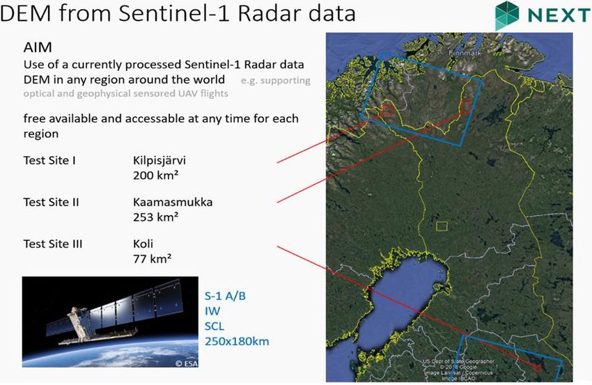
To produce a much higher resolution DEM in the test sites shown below, which were selected
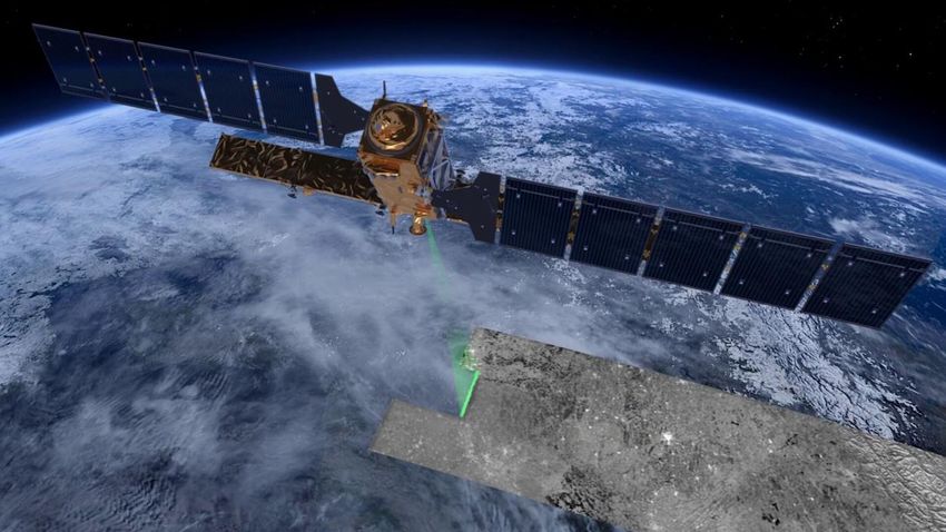
together with RADAI, we relied on Sentinel-1 radar imagery. As its name implies, Sentinel-1
was the first of the Copernicus Programme satellite constellation to be put in orbit by the
European Space Agency. In this video-link, the European Space Agency explains how Sentinel-
1 can image the surface of the Earth through cloud and rain and regardless of whether it is
day or night.
The figure below shows the results of processing a rapid and current DEM from Sentinel-1
data for three selected test sites in Finland.
This project has received funding from the European Union’s Horizon 2020
research and innovation programme under Grant Agreement No. 776804
Disclaimer: This document reflects only the author’s views and the Community is not liable for any use that may be made of
the information contained therein.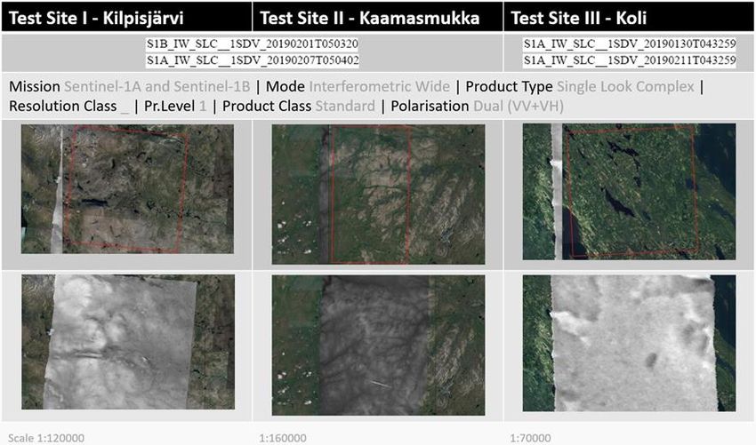
Figure 1: Location of the three test sites in Finland

      Figure 2: Processing a rapid and current DEM from Sentinel-1 data in the selected test sites

                                    This project has received funding from the European Union’s Horizon 2020
                                    research and innovation programme under Grant Agreement No. 776804

Disclaimer: This document reflects only the author’s views and the Community is not liable for any use that may be made of
the information contained therein.
Which factors led to the idea of developing a Satellite Image Crawler in NEXT?
Our original plan was to develop an automated downloader for satellite data that would serve
the needs of the exploration as well as of the mining industry. Back in 2016, this was still a
mostly uncharted technical territory. As ever newer technologies in the domains of IT, neural
networks, cloud processing and machine learning emerged, the market witnessed a very rapid
increase in suppliers of fully automated download software and it did not take long for even
publicly accessible and open-source software solutions to become available as well.
In consultation with the NEXT Advisory Board, we shifted our originally intended focus of
software development to developing a stand-alone, web-based tool that would offer users
access to our results in NEXT. We realized that over time such an online portal will permit us
to showcase results also for other areas with new challenges and therefore also with new
parameters to be taken into account. This implied that we had to envision this new concept
with an appropriately flexible user-oriented functionality, which in itself presented us with a
multitude of new questions and challenges.
Our Satellite Image Crawler (SIC) is currently being developed as a post-processing service and
is intended as a tool that masters and combines the functions of both searching and analysing.
Thus, this universal software tool for data search, acquisition, analysis, storage and post-
processing can be used as a one-stop service by customers. Its uniqueness lies with the fact
that it showcases the technical added value of our developments in an easy-to-interpret way.
This makes it an especially worthwhile offer to customers such as smaller companies and
start-ups in the exploration industry.
Prospective customers will be able to access the system via a web-based user interface. Once
logged in, they can define their area of interest on the basis of an OpenStreetMap layer, enter
the time period for the satellite scenes to be used, with the option to select a single one-time
analysis or a complete time series analysis, among additional parameters. On completion of
these preliminary steps, the user is invited to select from our portfolio of satellite image
derived products. This last step triggers off the start of an automated data search on the
European Space Agency (ESA) Hub and of any satellite data already stored on our server.
Finally, the user will receive a notification when the desired product has been generated and
is ready for download.
This project has received funding from the European Union’s Horizon 2020
research and innovation programme under Grant Agreement No. 776804
Disclaimer: This document reflects only the author’s views and the Community is not liable for any use that may be made of
the information contained therein.Once fully developed, our Satellite Image Crawler will fulfil the requirements that we
envisioned back in 2016 and therefore much before the start of the NEXT project, i.e. a fully
automated downloader of satellite imagery. However, the added functionality of automated
post-processing is expected to attract the active interest of exploration and mining companies
alike.
More about NEXT: www.new-exploration.tech
This project has received funding from the European Union’s Horizon 2020
research and innovation programme under Grant Agreement No. 776804
Disclaimer: This document reflects only the author’s views and the Community is not liable for any use that may be made of
the information contained therein.You can also read