North American Seasonal Fire Assessment and Outlook
←
→
Page content transcription
If your browser does not render page correctly, please read the page content below

North American Seasonal Fire Assessment and Outlook
National Interagency Fire Center ● Natural Resources Canada ● Servicio Meteorológico Nacional
United States Canada Mexico
Outlook Period July through September 2022
Issued 12 July 2022
Executive Summary
A prime example of heavy winter snow and a deep snowpack having little effect on summer fire activity
was readily apparent in June into early July as widespread large wildfires ignited across the Yukon
Territory. Similar situations occurred in northern parts of the western provinces, with increasing numbers
of fires, many of which have stayed active during the latter half of June and early July. While the
Northwest Territories has multiple large active wildfires, winter snow cover was light in many regions,
so increasing fire activity in late May and early June was not surprising. A large upper ridge moving
slowly from Alaska over Yukon and the Northwest Territories warmed northern temperatures in late
June and early July. Instability and spotty moisture led to numerous thunderstorms and lightning fires.
Activity in Yukon escalated quickly over the end of June and early July. Regular rain continued further
south, with localized flooding continuing in southern British Columbia and Alberta, drought reduction,
and elimination of fire activity and high fire danger along the eastern slopes of the Rockies. Timely
precipitation and moderating fire weather managed to curtail significant fire activity in much of the rest
of Canada during June and early July. Above normal fire potential is forecast across much of central
and western Canada through August, with above normal potential continuing across much of central
Canada and southern British Columbia and Alberta in September.
Fire activity gradually increased in June across much of the West, except for the Southwest, which saw
a rapid decrease in activity during the latter half of June. Fire activity rapidly increased across Alaska,
with activity continuing at low to moderate levels in the Southern and Eastern Areas. Most of the West,
Plains, and Texas remain in drought, with areas of extreme to exceptional drought across the
southwestern US. Drought developed across southwest Alaska and expanded or increased in severity
across the Southeast and Hawai’i. Alaska will continue with above normal significant fire potential into
August, with leeward locations of the Hawai’ian Islands likely to have above normal potential through
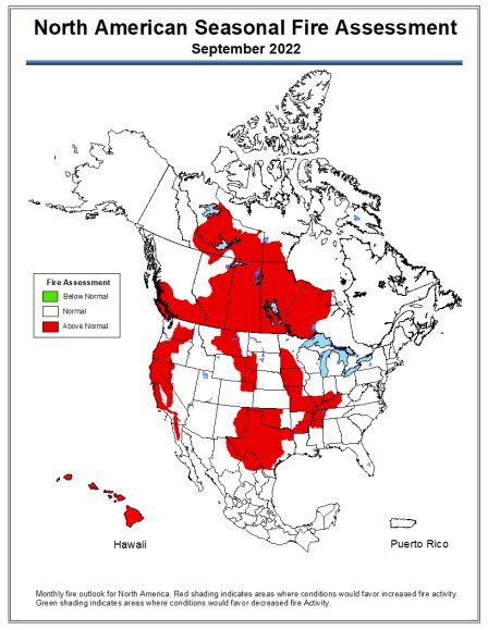
Monthly fire outlook for North America for July 2022 (left), August 2022 (middle), and September 2022 (right).
Red shading indicates areas where conditions would favor increased fire activity. Green shading indicates areas
where conditions would favor decreased fire activity. Click on each image to see larger versions.
September. Above normal significant fire potential is expected across the higher terrain of California
and mostly along and east of the Cascades in the Pacific Northwest through summer. Above normal
fine fuel loading also indicates above normal potential in western and northern portions of the Great
Basin in July and August. Much of Oklahoma and Texas and portions of the northern and central High
Plains are expected to have above normal potential through much of summer, while the Lower Missouri,
Mid-Mississippi, and lower Ohio Valleys are forecast to have above normal potential by September.

Mexico is beyond its peak wildfire season and the rainy season has begun. Some wildfire activity
continues in northern Baja California and near the Mexico-Texas border. National precipitation was
above average in April and June, but below normal in May, with overall slightly above normal
temperatures April through June. Drought increased across much of Baja California, Sonora,
Chihuahua, Coahuila, and Nuevo Leon, and this will likely continue into September due to forecast
warmer and drier than normal conditions across these areas as La Niña continues to affect the weather
and climate. Above normal significant fire potential is expected along portions of the Mexico-Texas
border and inland areas of northern Baja California through the outlook period as drought is expected
to intensify.

Critical Factors The critical factors influencing significant fire potential for this outlook period are:

El Niño-Southern Oscillation (ENSO): La Niña conditions remain,
with below average sea surface temperatures (SSTs) over much of
the equatorial Pacific Ocean. SSTs have begun to warm, with weak
La Niña to neutral conditions forecast this summer by the Climate
Prediction Center (CPC). This fall, SSTs may cool again in the
equatorial Pacific Ocean, with CPC forecasting a near 60% chance of
La Niña in the early fall. The negative Pacific Decadal Oscillation
(PDO) continues as well, but La Niña remains the dominant climate
signal. The effect of La Niña will weaken over the summer, but an
increase in its influence is possible this fall.

Drought: Drought reduction occurred in the western Provinces, with
rain eliminating the extensive extreme drought in Alberta and
Saskatchewan, leaving a tiny patch in southeast Alberta. While
abnormally dry to moderate drought still covers southern Alberta and
southwest Saskatchewan, the extent of each category is now smaller.
Abnormally dry to moderate drought remains in the southern interior
of British Columbia, although the moderate drought area is now
discontinuous. Drought development or intensification occurred from
northern Saskatchewan into the eastern Northwest Territories, with
areas also present in east-central and northwest Yukon. Spots of
moderate drought have appeared in north-central Saskatchewan and
northwest and northeast of Great Slave Lake in the Northwest
Territories. Elsewhere, a few isolated abnormally dry areas are
present.

Drought continues across more than 75% of the West and much of
the central and southern Plains, with extreme to exceptional drought
continuing over much of California, eastern Oregon, the Great Basin,         Top: Canadian Drought Monitor for
                                                                             June 30 (from Agriculture and Agri-
New Mexico, and Texas. Drought developed or intensified over                 Food Canada). Middle: United
portions of Alaska, Hawai’i, New England, the Southeast, and Ohio            States Drought Monitor for July 5
Valley. Drought improvement and removal was noted across much of             (from US National Center for
the Northwest, Idaho, and Montana, but a small area of drought               Environmental         Information).
intensification occurred over the Front Range of north-central               Bottom: Mexican Drought Monitor
                                                                             for June 30 (from CONAGUA-
Montana.                                                                     Servicio Meteorológico Nacional).
During the second half of June, above average rainfall was observed across much of Mexico, due to
Hurricane Blas, which had a greater impact along the Pacific coast, Tropical Storm Celia, low pressure
in the Gulf of Mexico, and the North American Monsoon. There was a decrease in abnormally dry
conditions in the states of Colima, Michoacán, Guerrero, southern Veracruz, Chiapas, and Tabasco, as
well as a reduction in areas with moderate to severe drought in Baja California Sur, Sinaloa, Durango,
southern Chihuahua, Nuevo León, Nayarit, Michoacán, Veracruz, and Puebla. In Baja California,
Sonora, and the north of Chihuahua, extreme drought decreased. However, in the areas of the country
that experienced below-average rainfall, such as the central region, portions of the western Mexico, and
the Sierra Madre Oriental, drought increased. In Jalisco, the abnormally dry category increased, in
Morelos and southern Puebla, an area with moderate drought emerged, while severe to exceptional
drought spread in the states of Coahuila, Nuevo León, Tamaulipas, Zacatecas, Guanajuato and
Querétaro. As of June 30, the area with moderate to exceptional drought was 47.5% nationwide, 5.5%
less than what was observed as of June 15.

Fire Season Status: After a slow start to the 2022 fire season, activity has increased quickly in northern
regions, in Yukon and the Northwest Territories, and close to the 60th parallel in the western provinces.
Hot and dry weather with thunderstorm activity has triggered many fires. Some of these have occurred
in tundra regions or areas without historical fire records in Natural Resources Canada’s database.
These fires may be occurring in areas without previous activity, or they may indicate a lack of historical
fire records in these remote areas.

Most of the fire activity to date in northern Canada is occurring in regions with sparse infrastructure and
population, although some road closures have created access problems as smoke and fires pass
through. A few evacuations have also resulted. With a rapidly increasing fire load, blazes will likely
eventually affect communities and other infrastructure. As of July 8, over 100 fires were burning in
Yukon, while the Northwest Territories had the most area burned to date at about 158,000 hectares.
The largest fires are in the Northwest Territories, with several over 10,000 hectares and at least two
over 30,000 hectares. Fires approaching this size are also burning in Alberta and Saskatchewan.

As of July 8, Canada recorded just over 2050 fires and 436,000 hectares burned year-to-date, a rapid
increase since June 29 when 1663 fires and about 143,000 hectares burned year-to-date. Some of this
apparent increase could reflect new mapping data; however, weather conditions in the north have been
conducive to widespread fire between late June and early July.

Fire activity increased rapidly across Alaska during June, with the geographic area preparedness level
rising to five on June 30. Hot and dry conditions at the beginning of June, followed by lightning across
southwest Alaska and the western Interior, ignited many of the fires, with fire activity continuing to
increase across the Interior through the end of the month. Fire activity gradually increased across
California, the Great Basin, the Inland Northwest, and Rockies, but a rapid decrease in fire activity
occurred during the latter half of June in the Southwest due to the North American Monsoon. Fire activity
continued at low to moderate levels in the Eastern and Southern Areas. Year-to-date fire statistics
through 10 July showed 35,711 fires burned a total of 1,960,712 hectares (4,845,026 acres). These
totals are 123% and 197% of the 10-year average for fires and hectares burned, respectively.

So far this year, 6,305 forest fires have occurred in 32 states resulting in 614,286 hectares burned. Of
this area, nearly 94% burned in grass and shrubs, with just over 6% of the area in timber. States with
the greatest number of fires were the state of Mexico, Jalisco, Mexico City, Michoacan, Chihuahua,
Chiapas, Puebla, Durango, Veracruz, and Morelos, representing over 80% of the fires. States with the
largest area burned were Guerrero, Durango, Jalisco, Chiapas, Chihuahua, Sonora, Nayarit, Oaxaca,
Tamaulipas, and Michoacán, representing over 82% of the area burned. Of these fires, 991 or 16%,
correspond to fire-sensitive ecosystems, resulting in an area burned of 75,876 hectares, or 16% of the
national total.

Canada Discussion

July/August/September: Areas of much above normal significant fire potential are expected between
Great Slave and Great Bear Lakes in the Northwest Territories and around the junction of the
Saskatchewan, Manitoba, Northwest Territories, and Nunavut borders during July. Forecasts of above
normal severity surround these areas, and cover Yukon, northern British Columbia, and Alberta, all of
Saskatchewan, Manitoba, and western Ontario. While July’s predicted above normal area does not
include southern British Columbia, the fire season in this westernmost province often begins in mid-
July. Some fire starts over the coming month should be expected, but at a slow to normal pace.

In August, areas with expected above normal significant fire potential should shift to the south and east
compared to July. While Yukon, the northwestern Northwest Territories, and much of northern British
Columbia show a return to normal conditions, forecast above normal potential extends from southern
British Columbia into western Quebec. The area of much above normal potential expands to cover the
region from Great Bear Lake southward across the 60th parallel, clipping extreme southeast Yukon,
northeast British Columbia, and northern Alberta. This region continues east to include central and
northern Saskatchewan, all of Manitoba, and far western Ontario.

During September, Canadian fire activity normally begins to dwindle, especially in northern regions as
daylight hours shorten, longer and cooler nights help retain moisture, and thunderstorm activity wanes.
The 2022 forecast follows this, and predicts normal fire activity in Yukon, the western Northwest
Territories, northern British Columbia, and northwestern Alberta. Above normal potential is still expected
in the eastern Northwest Territories, the remaining Prairie areas, and Ontario west of Lake Superior. In
much of these regions, new fire starts are likely to dwindle; however, deep-burning fires may continue
to be active into the autumn.

United States Discussion

July/August/September: Climate outlooks indicate below normal precipitation is likely across much of
the Plains through the central Rockies into the Inland Pacific Northwest, with above normal
temperatures likely across most of the contiguous US (CONUS) through summer. A robust North
American Monsoon is expected to continue through July into August across the Southwest and portions
of the broader Four Corners region. Alaska is likely to remain warm, with near normal precipitation likely
through summer.

Above normal significant fire potential is forecast for the southern Plains through September, spreading
across Texas, the Lower to Mid-Mississippi, Missouri, and Ohio Valleys by fall. Much of the central and
northern High Plains, including the Black Hills, are likely to have above normal potential through
summer. The Southwest, southern Great Basin, and Colorado Rockies have returned to near normal
potential.

Southwest, south-central, and Interior Alaska will have above normal significant fire potential through
August, although portions of southwest Alaska will likely return to near normal potential during August.
Much of the Sierra and Coast Ranges in California will have above normal significant potential by
August, continuing through September. Along and east of the Cascades into much of the western and
northern Great Basin is expected to have above normal potential this summer due to above normal fine
fuel loading and long-term drought, with southwest Oregon likely to have increasing potential by August.
Leeward sides of the Hawai’ian Islands will have above normal potential through September due to
ongoing drought and likely enhanced trade winds.

Mexico Discussion

July/August/September: Precipitation is likely to be below normal across much of Mexico in July,
except for portions of southwest Mexico, especially along the Pacific coast. During August, below
normal precipitation is forecast across the northern half of Mexico, with the southern half forecast to
have above normal precipitation. In September, precipitation is likely to be above average across much
of the country except portions of Baja California, Chihuahua, Nuevo Leon, Coahuila, and Durango.
Above normal temperatures are likely for much of the country through September except potentially in
portions of Baja California and sporadic locations along both coasts.

Given the widespread drought, forecast rainfall and temperature patterns for the North American
Monsoon and tropical storm activity, and considerations for typical fire activity, above normal significant
fire potential is expected along the Mexico-Texas border and inland locations of northern Baja
California. Northeast Chihuahua, northern Coahuila, and northwest Nuevo Leon are currently forecast
to have above normal potential, with eastern slopes of the Peninsular Ranges in northern Baja California
as well.

Additional Information
Additional and supplemental information for this outlook can be obtained at:

United States:
National Significant Wildland Fire Potential Outlook
http://www.predictiveservices.nifc.gov/outlooks/monthly_seasonal_outlook.pdf

Canada:
Canadian Wildland Fire Information System
http://cwfis.cfs.nrcan.gc.ca/home

Mexico:
Servicio Meteorológico Nacional
http://smn.cna.gob.mx/index.php?option=com_content&view=article&id=156&Itemid=113

Outlook Objective
The North American Seasonal Fire Assessment and Outlook is a general discussion of conditions that
will affect the occurrence of wildland fires across Canada, the United States, and Mexico. Wildland fire
is a natural part of many ecosystems across North America. This document provides a broad
assessment of those factors that will contribute to an increase or decrease of seasonal fire activity. The
objective is to assist wildland fire managers prepare for the potential variations in a typical fire season.
It is not intended as a prediction of where and when wildland fires will occur nor is it intended to suggest
any area is safe from the hazards of wildfire.

Acknowledgements
Contributions to this document were made by:

Canada:        Richard Carr, Natural Resources Canada
               Ginny Marshall, Natural Resources Canada

United States: Nick Nauslar, Predictive Services, Bureau of Land Management
               Jim Wallmann, Predictive Services, US Forest Service
               Julie Osterkamp, GIS, Bureau of Land Management

Mexico:        Martín Ibarra, Servicio Meteorológico Nacional
               Dario Rodríguez, Servicio Meteorológico Nacional
               Abril Z. Espejo Madrigal, Servicio Meteorológico Nacional
               Jose L. Solis Aguirre, Servicio Meteorológico Nacional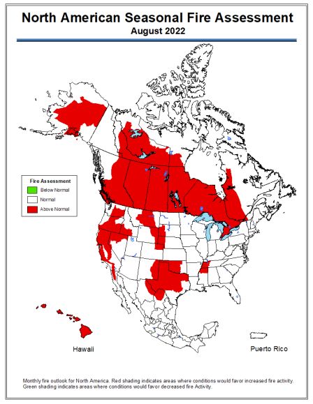
You can also read