NORTH ISLAND, NEW ZEALAND - INTRODUCTION TO TEPHRA-DERIVED SOILS AND FARMING, WAIKATO-BAY OF PLENTY
←
→
Page content transcription
If your browser does not render page correctly, please read the page content below
INTRODUCTION TO TEPHRA-DERIVED SOILS AND
FARMING, WAIKATO-BAY OF PLENTY,
NORTH ISLAND, NEW ZEALAND
NEW ZEALAND WINTERIM 2019
University of WisconsinPlatteville, USA, and University of
Waikato, New Zealand, 15-17 January 2019
David J. Lowe and Megan R. Balks
School of Science (Earth Sciences)
University of Waikato, Hamilton
Note about ages: Ma = millions of years ago; ka = thousands of years ago; BP = before present, ‘present’ being
defined as AD [CE] 1950 for radiocarbon-derived ages. Radiocarbon (14C) ages are given in calendar or calibrated
(cal) years BP unless noted otherwise, or as calendrical dates (e.g. AD 232). The Holocene encompasses the last
11,700 cal years (Walker et al., 2009).
Photo on front cover (by Maria Lowe): Mt Pirongia and tephra-draped landscape, Waikato region
Citation: Lowe, D.J., Balks, M.R. 2019. Introduction to tephra-derived soils and farming, Waikato-Bay of Plenty,
  North Island, New Zealand. University of Wisconsin-Platteville Education Abroad Program: Winterim Field Trip
  (15-17 January, 2019). School of Science (Earth Sciences), University of Waikato, Hamilton. 82 pp.
                                                         2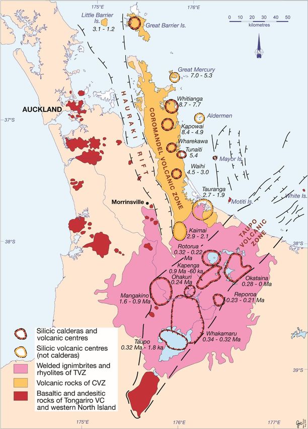
Provisional itinerary
Tuesday 15 January 2019: Farming and conservation
8.00 am Depart Bryant Hall
8.00-8.45 am Drive to Ormsby Farm, Pekanui Rd, Ngutunui (Pirongia Mtn)
Meet Megan at Ngutunui School
9.00-10.30 am Keith and Margaret Ormsby dairy farm, Pekanui Rd
10.30-11.00 am Drive to Otorohanga
11.00-12.00 Otorohanga Kiwi house and bird sanctuary
12.00-12.45 Lunch at Ronnies Café, Otorohanga
12.45-1.30 Drive to Garland Farm, Rahiri Rd, Roto-o-rangi (Maungatautari Mtn)
1.30-3.30 Bill and Sue Garland sheep and beef farm
3.30-4.15 Special afternoon tea at nearby farm, Cambridge Rd (US connection)
4.15-4.30 Drive to Leamington section
4.30-5.00 Horotiu soil on late Quaternary tephra mantle (allophanic) on volcanogenic alluvium, Leamington
(Vitric Hapludand)
5.00-5.30 Return to Bryant Hall, Knighton Rd, Hamilton

Wednesday 16 January 2019: Rotorua geysers and tephras
8.30 am Depart Bryant Hall
8.30-10.00 Drive to Te Puia, Hemo Rd, Rotorua
        10.00 Arrival at Te Puia
        10.15 Concert
        11.00 Guided tour
12.15-1.00 Lunch at Te Puia or local eatery (e.g. BP Connect)
1.00-1.30 Drive to Brett Rd, Lake Rerewhakaaitu
1.30-2.30 Rotomahana soil on layered Holocene tephras, buried soils (Typic Udivitrand)
2.30-2.45 Circumnavigate Lake Rerewhakaaitu (view Mt Tarawera)
2.45-3.15 Drive to Okareka Loop Rd tephra section
3.15-3.45 Okareka Loop Rd tephra section
3.45-4.30 Redwood forest (Long Mile Drive)
4.30-6.00 Return to Bryant Hall, Knighton Rd, Hamilton

Thursday 17 January 2019: Waikato peats and gardens
8.30 am Departure
8.30-8.45 Drive to Raynes Rd
8.45-9.30 Kainui soil, late Quaternary tephra mantle (halloysitic) on buried clayey paleosol (Typic Kandiudult)
9.30-9.45 Drive to Moanatuatua bog and blueberry orchard, Jary Rd, Ohaupo
9.45-10.15 Rukuhia soil on peat with thin tephra layer (Taupo Tephra 232 ± 10 CE) (Sapric or Typic
Haplohemist)
10.15-10.20 Drive to The Orchard Café, Blueberry Country processing sheds, Jary Rd
10.30-11.15 Talk about blueberry operation by Warrick Macdonald (general manager, Blueberry Country)
11.15-11.45 Drive to Pirongia village
11.45-12.30 Lunch at bakery in Pirongia
12.30-12.45 Drive to Grey Rd and visitor centre, Mt Pirongia
12.45-1.30 Mangakara forest walk, Mt Pirongia
1.30-2.15 Drive to Hamilton Gardens, Cobham Drive
2.15-3.00 Te Parapara garden (human-modified soils) (Tamahere soils), Hamilton Gardens with talk by
Wiremu Puke
3.00-4.30 Free time, Hamilton Gardens
4.30-5.00 Return to Bryant Hall, Knighton Rd, Hamilton

                                                       3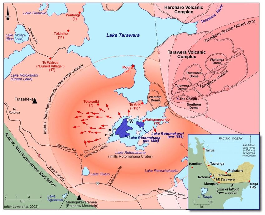
Introduction to volcanism and its products
Volcanoes are not only conical mountains, but span a very wide range of landforms. A volcano is any landform
that results from molten rock (magma) being erupted at the Earth’s surface. The size and shape of a volcano
reflect how often it erupts, the sizes and types of eruptions, and the composition of the magma it produces.
Magmas contain almost all of Earth’s known chemical elements but typically they comprise only nine – silicon,
oxygen, aluminium, magnesium, iron, calcium, sodium, potassium and titanium – that sum 98% or more by
weight. Oxygen and Si together are generally the most abundant elements, making up 48–76 % by weight of
most magmas. The chemistry of magma, especially Si content, is important for influencing the way it erupts,
and three main magma types, and resulting volcanic rocks, are identified on the basis of their chemical
composition. A fourth type, dacite, is usually grouped with andesites but is intermediate between andesite
and rhyolite in composition (Smith et al., 2007).
Basalt is rich in Fe and Mg and low in Si and erupts at very high temperatures (~1100–1200 C) as a very fluid
magma. Basalt magma with very little gas cools to form dark black, dense lava, but where magma erupts with
lots of gas it cools to form ragged scoria or ash.
Rhyolite magma is rich in Si, K and Na and erupts at temperatures between 700–850 C as an extremely
viscous magma. Rhyolite magma containing lots of gas bubbles cools to form pumice, but if the magma
contains little gas it may form obsidian glass.
Andesite (also dacite) magma is intermediate in composition and physical properties. Erupting at ~800–1000
C it is more viscous than basalt, but much less viscous than rhyolite. Andesite magma cools to form dark grey
lava if gas-poor or scoria or ash if gas-rich.
Volcanic eruptions vary remarkably in style and size. The smallest may just dust the summit of a volcano with
volcanic ash, whereas the largest are capable of creating entirely new landscapes across whole countries.
Although there is great diversity of volcanic behaviour, eruptions can generally be classed as one of two broad
types – either explosive or effusive.
Explosive eruptions
Explosive eruptions are caused by gases violently ripping apart and shattering magma into pieces which cool
and solidify into pumice (if the magma is rhyolite), scoria (if the magma is andesite or basalt), and volcanic ash
(sand and dust-sized fragments mainly of volcanic glass). Explosive eruptions take place in one of two ways.
The first involves gas that is contained within the magma at depth. As magma rises to the surface the drop in
pressure causes these gases to bubble and expand violently. Close to the surface magma becomes like the
foam that explodes out of champagne or a can of fizzy drink when first opened. The second type of explosive
eruptions occurs when magma contacts water, either beneath the ground (at an aquifer) or at the land surface
(either a lake or the sea). The very high temperature of magma (700–1200 C) means that it instantly boils the
water, causing violent steam explosions, which blow apart the magma, eject liquid water and steam, and rip
up the ground containing the water. These types of eruptions are called phreatomagmatic eruptions.
In both types of explosive eruptions, the shattered magma and other rock fragments are carried violently into
the air by the uprush of expanding gases, before settling back to the ground to form a pyroclastic (literally
‘fiery fragmental’) deposit. The more explosive the eruption the more energetic this roaring stream of gas, and
the higher the tephra and rock fragments will be carried into the air. The higher the material goes, the further
from the volcano it will be blown by the wind, and so there is a close correlation or relationship between the
energy of an eruption and how far the eruption products are spread (Smith et al., 2007).
4
Effusive eruptions
Effusive eruptions occur when magma contains little gas and so cannot behave explosively, but instead quietly
extrudes at the surface forming flows of lava. The very fluid basalt lavas can flow long distances forming
extensive, almost flat volcanoes, whereas very viscous rhyolite lava piles up around the vent, like toothpaste
squeezed from a tube, forming large, steep-sided mounds called domes.
Three different types of volcanoes in North Island
Although North Island’s active volcanoes look quite different from one another, all can be grouped into one
of three main landform types:
classic cones or stratovolcanoes (e.g. Mt Taranaki, Mt Ruapehu)
volcanic fields (e.g. Auckland Volcanic Field, South Auckland Volcanic Field); and
caldera collapse craters (e.g. Rotorua caldera, Taupo caldera, Haroharo caldera)
Each of these has obvious landforms and the violence and styles of eruptions are unique to each. These
differences reflect the type of magma erupted: basalt at the volcanic fields, andesite at the cone volcanoes,
and rhyolite at the calderas. During our trip, we will see mainly rhyolitic or dacitic deposits and landforms
Caldera volcanoes and eruptions
A caldera is a large, deep crater resulting from the caving in of a rhyolite magma chamber. In places the caldera
walls can be seen as steep cliffs, but many are difficult to observe in the landscape because they may be filled
in with erupted material or covered by water. Calderas have extremely violent origins and form when a vast
amount of viscous rhyolite magma, bubbling with gas, erupts explosively from a magma chamber that may
only be a few kilometres beneath the ground. During these eruptions, so much magma is erupted that the
chamber empties, leaving the ground above it unsupported. This area collapses, dropping like a piston, to form
a wide, deep depression. Lake Taupo, the area to the east of Rotorua known as Okataina, and Mayor Island or
Tuhua, are three examples of recently active caldera volcanoes in New Zealand. Some older calderas exist in
the area between Taupo and Rotorua and on the Coromandel Peninsula (see Fig. 2 below).
Rhyolite calderas may be active for several hundred thousand years, but large eruptions are rare, with typically
thousands of years between events. Caldera collapse is not the only effect on the landscape arising from these
large explosive eruptions. Huge quantities of pumice, ash and gas are pumped into the atmosphere, and
through a combination of heat and momentum, a roiling column of this material may rise to over 50 km above
the caldera. From this height, ash and especially aerosols – gases and tiny drops of acid – can spread around
the globe, affecting the world’s climate for several years. Closer to the caldera the landscape may be buried
by metres of pumice. The most devastating process, however, occurs when this column of material falls back
to earth like a fountain, then surges out in all directions from the caldera as a hurricane-like billowing, ground-
hugging flow of hot pumice, ash and gas. These pyroclastic flows or ‘density currents’ can travel over 100 km
at the speed of a racing car, leaving behind a layer of volcanic (pyroclastic) debris that might be more than 100
metres deep. Some flows are so hot (600-700 C) and thick that the ash and pumice fragments weld back
together, forming solid rock known as partially or densely welded ignimbrite (Smith et al., 2007).
Dome building
Eruptions from rhyolite volcanoes are not always so explosively catastrophic. A small amount of rhyolite
magma may remain after a caldera eruption, which is exhausted of all gas and so can only ooze from the
volcano slowly, often along the faults and fissures opened up by earlier caldera collapse. The very high viscosity
means the silica-rich rhyolite lava will not flow far, and instead, piles up around the vent, like toothpaste
squeezed from a tube, to form a steep-sided dome or dome complexes. These domes are prominent landscape
features amongst the caldera volcanoes of the Taupo Volcanic Zone (TVZ) (Fig. 1). Mokoia Island and Mt
Ngongataha are rhyolite lava domes erupted within Rotorua caldera, and Mt Tarawera comprises a collection
of lava domes erupted c. AD 1314 within Haroharo/Okataina caldera.
5
Defining tephra, ash, and lapilli
‘Tephra’ comes from a Greek word tephra meaning ashes, and is an all-encompassing term for the explosively
erupted, loose, pyroclastic (fragmental) products of volcanic eruptions (Lowe, 2011). It includes all grain sizes
ranging from the finest dust to blocks the size of cars. ‘Ash’ is not a burnt residue. Rather, it consists of particles
64 mm are called blocks if they are
sharp and angular in shape, or bombs if they are partly rounded or smooth in shape.

                           Table 1 Tephra-related nomenclature in brief (from Lowe, 2011).

                                                          6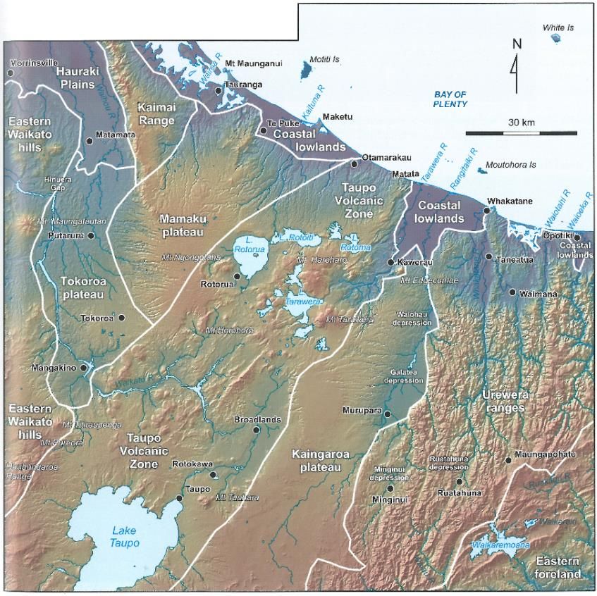
Quaternary volcanism in Taupo Volcanic Zone

The highest concentration of Quaternary volcanic activity in New Zealand occurs in the TVZ. This narrow band
of cone and caldera volcanoes extends from Ruapehu in the south, over 240 kilometres to Whakaari (White
Island) in the north, with the Taupo, Okataina, Rotorua and other calderas nestled between. Some of the
planet’s largest and most violent volcanic eruptions have occurred from this zone, as well as New Zealand’s
most recent small eruptions (Ruapehu 1995-1996, Whakaari 2000, Te Maari craters on Tongariro 2012).
Volcanism occurs in the TVZ, and at Taranaki, because of subduction of the Pacific tectonic plate beneath the
North Island. As this plate descends and is heated, water and other fluids are boiled off and stream into the
mantle rocks under the North Island. These fluids cause chemical changes that enable the otherwise solid rock
of the mantle to melt, forming basaltic magma. This magma rises until, because of its higher density, it gets
trapped underneath the continental crust of the North Island. Here the very hot basalt magma acts like a
gigantic blow-torch, melting the crust and mixing with it to form andesite magma, which is then erupted as
cone volcanoes. Where enough melting of the continental crust occurs, rhyolite magma forms, generating
caldera volcanoes (Smith et al., 2007).

Fig. 1 Simplified North Island plate tectonic setting and main volcanic centres and caldera volcanoes active in the
Quaternary (based on Leonard et al., 2010). North Island lies entirely on the Australian Plate. Diagram at right courtesy
of Adrian Pittari.

                                                           7
Fig. 2 Volcanic centres and the ages of activity and rocks (including welded ignimbrites) of central North Island. Diagram
courtesy of Roger Briggs (after Briggs et al., 2005).
                                                            8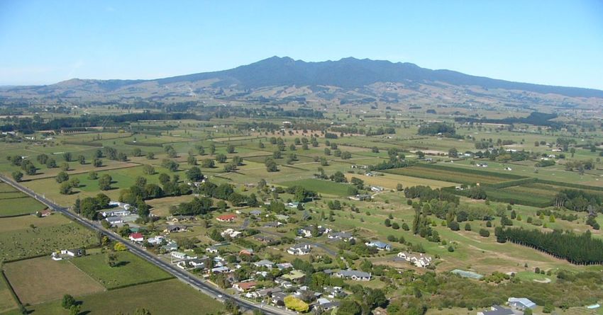
TVZ
The TVZ comprises three distinct parts (Fig. 1). A southern part, dominated by andesite cones, includes the
active Ruapehu and Tongariro volcanoes and the probably extinct Pihanga and Tihia-Kakaramea cones. A
northern part, which is also dominated by andesite stratovolcanoes, includes the active Whakaari (White Is.)
and mid-Holocene Putauaki (Edgecumbe), and the much older, deeply eroded cones of Motuhora (Whale Is.)
and Manawahe. These two stratovolcano clusters book-end the third and largest central part of the zone,
extending from Turangi north to the Rotorua lakes district. This area is dominated by rhyolite calderas,
including the highly active Taupo and Okataina volcanoes (Figs. 1-2), and older calderas including Mangakino,
Kapenga, Whakamaru, Reporoa, Rotorua, and newly-identified Ohakuri caldera (Gravely et al., 2007). The
origins and extent of Rotorua caldera are debated. Large explosive eruptions over the last 2 million years or
so from this nested collection of rhyolite volcanoes have produced a huge volume of pyroclastic deposits,
which when loose are called tephras (Table 1), and many of the older volcanoes cannot be seen in the
landscape because of burial underneath hundreds of metres of volcanic material from more recent eruptions.
The products of these caldera eruptions are most obvious as the extensive plateaux flanking the western and
eastern sides of the TVZ, which erosion reveals to be made up of many layers or sheets of ignimbrite, pumice,
and tephra fallout layers. However, caldera eruption products are found far beyond the more obviously
volcanic landscape of the central North Island. If we consider a volcano as including all the material erupted
from it, then in a sense the entire area from Auckland to Hawkes Bay is part of a huge caldera volcano centred
on TVZ.
Introduction to Taupo Volcanic Centre and the Taupo eruption
Taupo volcano (Fig. 2) is the most frequently active and productive rhyolite volcano on Earth. Activity began
after the eruption of the widespread and voluminous c. 340 ka Whakamaru group ignimbrites, including
widespread Rangitawa tephra from Whakamaru caldera. Modern activity began c. 50 ka with nearly 40
eruptions recognised (Fig. 3). These were overwhelmingly pyroclastic (>95%) and from vents mostly now
concealed beneath Lake Taupo (Wilson et al., 2006). Pyroclastic deposits exposed in the Taupo-Maroa area
represent 11 eruptions from c. 50 ka to c. 25 cal ka, and then the phreatomagmatic Kawakawa/Oruanui
eruption occurred at c. 25 cal ka. This super-eruption was extremely voluminous with a total dense-rock
equivalent (DRE) volume of ~530 km3 (equivalent to nearly 1200 km3 as bulk pyroclastic material) (Wilson et
al., 2006), and it generated one of the most widespread and stratigraphically useful tephra-fall deposits in the
New Zealand region (Wilson, 2001; Wilson et al., 2006; Lowe et al., 2008, 2013; Holt et al., 2010). Caldera
collapse associated with this eruption generated most of the modern outline of the basin now partly filled by
Lake Taupo, and much of the central North Island landscape was changed as a consequence of the eruption
(Manville, 2002; Manville and Wilson, 2004; Wilson et al., 2009).
Since the Kawakawa eruption (also known as the Oruanui eruption, hence now referred to as
Kawakawa/Oruanui event), there have been a further 28 eruptions, all but three taking place in the last 12,000
cal years. The most recent (apart from lava extrusion of eruption Z – regarded in some papers as part of the
Taupo eruption sequence: Houghton et al., 2015) was the extremely powerful ‘ultraplinian’ caldera-forming
Taupo eruption event (Wilson and Walker, 1985; Wilson, 1993) (Table 2). Wilson (1993) erected a
volcanological nomenclature for these 28 events beginning with (the oldest) followed by , A, …, and Z.
Other names are also used for some of them (Froggatt and Lowe, 1990).
9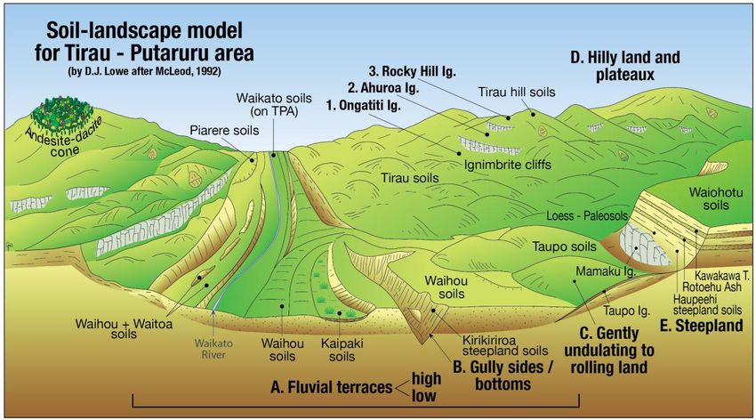
Fig. 3. Interfingering stratigraphic relationships, ages, and volumes (as non-vesiculated, void-free magma or dense-rock
equivalent, DRE; multiply by ~3 to obtain approximate bulk volumes) of tephras erupted from Okataina and Taupo caldera
volcanoes in North Island, New Zealand, since c. 50 cal ka (based on Wilson et al., 2009; Leonard et al., 2010; Danišík et
al., 2012). Eruptions from Maroa and Mayor Island volcanic centres are also recorded (Lowe et al., 2015). Earthquake Flat
tephra (EFT) (7 km3 DRE) was erupted from the Kapenga caldera volcano immediately after the Rototiti/Rotoehu eruption.
Ages on around 20 other widespread tephras erupted since 30,000 cal yr BP were revised by Lowe et al. (2013) using a
Bayesian age modelling approach.
                                                           10
Table 2 Summary of tephra names and ages and other information for 28 Taupo eruptives post-dating the
Kawakawa/Oruanui eruption c. 25 cal ka (after Wilson, 1993, 1994). Note that ages for some eruptives have been
modified since this table was published (Lowe et al., 2013)
Taupo eruption
The so-called Taupo eruption (eruption Y) took place in late summer to early autumn (typically late March to
early April) on the basis of fruit and seeds preserved in a buried forest at Pureora (Fig. 4) and the lack of an
outer latewood ring (Clarkson et al., 1988; Palmer et al., 1988; see Lowe and King, 2015). The eruption year
was AD 232 ± 10 AD based on dendrochronology and wiggle-match dating by Hogg et al. (2012, 2019). A total
eruptive bulk volume was estimated at ~105 km3 (~30 km3 DRE).
Fig. 4 Distribution of
Taupo ignimbrite
radially around Lake
Taupo and tephra
fallout isopachs (in cm)
derived from the
Taupo eruption (after
Hogg et al., 2012;
Houghton et al., 2014;
Wilson and Leonard,
2015).
11Fig. 5 Summary of the stratigraphy of pyroclastic deposits of the Taupo eruption (eruption Y of Wilson, 1993). Graphs at
right indicate qualitative changes in the inferred degree of magma-water interaction and the magma discharge rate
(which becomes ‘extreme’ during emplacement of Subunit Y6, Taupo ignimbrite) during the eruption. E = erosion horizons
formed by running water; S = erosion horizons from shearing beneath the fast-moving pyroclastic flow that deposited
the Taupo ignimbrite (after Houghton and Wilson, 1986; Houghton et al., 2015) (note: subunit Y7 = eruption Z in Table
2).
The eruption was complex, generating three phreatomagmatic (‘wet’) and two plinian (‘dry’) fall units, a multi-
flow intraplinian ignimbrite, and at the eruption climax, the extremely violently emplaced Taupo ignimbrite
(Subunit Y6) (Fig. 5). The duration of the entire eruption episode was of the order of tens of hours with a break
after Y3 (probably < 3 weeks). The height of the main ultra-plinian phase (Subunit Y5) eruption column has
been estimated at 50-55 km although Houghton et al. (2014) suggested that the eruption be ‘downgraded’ to
a plinian event with an eruption column height ~35-40 km; this phase lasted for ~6 to 17 hours (Walker, 1980).
The ignimbritic material was emplaced cataclysmically over about 400 seconds (~7 mins) by an extremely
energetic pyroclastic flow (also called a pyroclastic density current or PDC) moving at 200-300 m/s over a near-
circular area (~80 km radius) of c. 20,000 km2 around the vents (Wilson, 1985, 1993; Wilson and Walker, 1985;
Smith and Houghton, 1995). Its temperature was about 400-500 C at ~50 km from vent (within ~30-40 km of
the vent it was 150-300 C) (McClelland et al., 2004; Hudspith et al., 2009). The non-welded ignimbrite was
spread thinly over the landscape to generate an archetypal ‘low aspect ratio’ ignimbrite (Walker and Wilson,
1985). Ignimbrite-veneer deposits (IVD) are generally 0.5 to 1 m-thick and drape topographic highs; valley-
pond ignimbrites (VPI) infill valleys and depressions to depths of 5 to 60 m (Manville, 2001a). Because of its
extreme violence and energy release (150 ± 50 megaton TNT explosive yield, cf. Hiroshima bomb 0.015 Mt),
and by analogy with the 1883 Krakatau event, it is likely that the ignimbrite-emplacement phase generated a
volcano-meteorological tsunami that may have reached coastal areas worldwide (Lowe and de Lange, 2000).
The emplacement of the ignimbrite destroyed all forests in its path (about 1 km3 of timber), and then
ignimbrite contains numerous charred logs and charcoal, many of the logs notably being orientated radially
around the vents (Froggatt et al., 1981). Yet the forests recovered within 100-200 years (Clarkson et al., 1992,
1995; Wilmshurst and McGlone, 1996; Lowe and King, 2015).
The wide variation in eruption styles and dynamics relate to variations in discharge rate and the degree of
interaction between the magma and water in the proto-Lake Taupo (Wilson and Walker, 1985; Wilson, 1993,
1994; Houghton et al., 2010). Much of Lake Taupo was expelled, evaporated, or drained into a caldera-collapse
12structure beneath the current lake floor during the eruption. Afterwards it refilled over approximately 15 to
40 years, reaching a height of ~400 m, about 30-40 m above its present level (357 m) to form a semi-continuous,
wave-cut bench and highstand shoreline deposits (Manville et al., 1999, 2007, 2009). Catastrophic failure of a
pumiceous pyroclastic dam led to the restablishment of the Waikato River and the release of ~20 km3 of water
in a single phase, the peak discharge being 20,00040,000 m3/sec, equivalent to the Mississippi River in flood
(Manville et al., 1999). The break-out flood deposits can be traced 220 km downstream of Lake Taupo
(Manville et al., 2007) including on the low terrace that supports the Hamilton Gardens.
Introduction to Okataina Volcanic Centre and Kaharoa and Tarawera eruptions
The Okataina Volcanic Centre (Figs. 1-2) comprises two main parts, the northern Haroharo Volcanic Complex
(and Okareka embayment), and the southern Tarawera Volcanic Complex (centred on Mt Tarawera). Since c.
50 cal ka there have been at least 25 eruptions from Okataina (Fig. 4) and the most important tephras since c.
25,000 cal years ago are listed in Table 3 (below).
Kaharoa eruption
Most of us are aware of the basaltic Tarawera eruption on 10th June 1886: the high toll on life (~120 people),
landscape devastation, and loss of the Pink and White Terraces. But this was not the first time that Mt
Tarawera produced an eruption of importance both to volcanology and human history. The Kaharoa eruption
occurred at Mt Tarawera in the winter of 1314 AD (± 12 years) (Hogg et al., 2003; Sahetapy-Engel et al., 2014).
The importance of the Kaharoa eruption is at least threefold (Lowe and Pittari, 2014). (1) It is the most recent
rhyolite eruption in New Zealand, and the largest New Zealand eruption volumetrically of the last millennium.
(2) The Kaharoa tephra is an important marker horizon in late Holocene stratigraphy and geoarchaeology
(Vucetich and Pullar, 1964; Lowe et al. 1998, 2000), and in particular helps to constrain the timing of
settlement of early Polynesians in North Island, which occurred in c. AD 1280, a few decades before the
eruption (Newnham et al. 1998; Wilmshurst et al., 2008). (3) There is a link between the soils that developed
on the Kaharoa tephra, the animal ‘wasting’ disease known as ‘bush sickness’, and the birth of the government
soil survey group as an independent organisation (Tonkin, 2012).
Fig. 6. Isopach map of Kaharoa tephra fallout
blown firstly southeastward then
northwestward to generate the lobate
fallout pattern. The tephra isochron has been
extended using cryptotephra occurrences in
peats and lake sediments the Waikato and
Auckland regions (after Lowe et al., 1998).
13Table 3 Summary of main rhyolitic tephras deposited in the Rotorua-Galatea region since c. 25,400 cal yr BP.
Date or age¶
Name (source)* Description
Tarawera Tephra (Tr) 10 June 1886 Comprises basaltic scoria (Tarawera Scoria) with occasional
(Tarawera) rhyolite clasts and/or fine greyish brown ‘muddy’ ash
(Rotomahana Mud). Mud was dispersed more widely than
the scoria.
Kaharoa Tephra (Ka) 1314 ± 12 AD Fine to coarse white to grey ash, with occasional dense
(Tarawera) (636 12 pumice, rhyolite, obsidian and basalt lapilli. Contains
cal yr BP) abundant biotite.
Taupo Tephra (also known 232 ± 10 AD Creamy coloured coarse ash with plentiful shower-bedded
as Unit Y) (Tp) (1718 10 pumice lapilli (crushable). Ignimbrite unit always associated
(Taupo) cal yr BP) with charcoal fragments.
Whakatane Tephra (Wk) 5526 ± 145 Shower-bedded pale yellow coarse ash, overlying a fine to
(Haroharo) cal yr BP coarse rhyolitic (pale grey) ash. Rich in cummingtonite.
Reddish-brown uppermost horizon (sometimes with
basaltic Rotokawau tephra c. 4 cal ka).
Mamaku Tephra (Ma) 7940 ± 257 Loose, coarse yellowish-brown pumice ash grading into a
(Haroharo) cal yr BP weakly shower-bedded coarse ash/lapilli.
Rotoma Tephra (Rm) 9423 ± 120 Shower-bedded fine grey to yellowish brown ash with
(Haraharo) cal yr BP coarse ash layers, cummingtonite. Marked by a dark Ah
horizon at top, sometimes with charcoal, or podzolised.
Waiohau Tephra (Wh) 14,009 ± 155 Grey fine and coarse shower-bedded ash. Distinctive v. fine
(Tarawera) cal yr BP cream ash layer at the base. Usually has well developed
yellowish-brown or greyish upper soil horizon. Deposited a
few centuries before late-glacial cool episode (NZce-3) in
NZ-CES§.
Rotorua Tephra (Rr) 15,635 ± 412 Shower-bedded pumiceous yellowish lapilli or blocks
(Okareka embayment) cal yr BP (gravel). Occasional rhyolitic lithics. Deposited at start of
late-glacial mild episode (NZce-4) in NZ-CES§.
Rerewhakaaitu Tephra (Rk) 17,496 ± 462 Yellowish-brown ash grading down into tephric loess.
(Tarawera) cal yr BP Contains abundant biotite. Marks transition from Last
Glacial to post-glacial conditions (Termination I);
reafforestation occurred soon after deposition.
Okareka Tephra (Ok) 21,858 ± 290 Yellowish brown ash contains abundant biotite. Typically
(Tarawera) cal yr BP encased in yellowish to olive brown tephric loess.
Deposited just before stadial A (NZce-6) NZ-CES§.
Te Rere Tephra (Te) 25,171 ± 964 Yellowish-brown ash (typically encased in yellowish to
(Haroharo/Okareka) cal yr BP olive brown tephric loess).
Kawakawa Tephra (Kk) (also 25,358 ± 162 Olive brown to pale yellowish brown ash (typically encased
known as Oruanui) cal yr BP in yellowish to olive brown tephric loess). Deposited just
(Taupo) before interstadial D (NZce-9) in NZ-CES§.
*Terminology is based mainly on Froggatt and Lowe (1990). Descriptions generalised because character may differ from
proximal to distal locations and from site to site. The region has received additional distal tephras from Taupo and Tuhua
volcanic centres, and has been dusted regularly with andesitic tephra fallout from numerous eruptions at Tongariro
Volcanic Centre and Egmont/Taranaki Volcano, most recently in the 1995-96 Ruapehu eruptions.
¶
Ages are given in calibrated or calendar (cal) years (95% probability range) before present (BP). Ages are based on
Bayesian probability age modelling: Lowe et al. (2008, 2013). Calendar dates for the Kaharoa and Taupo eruptions have
been determined by dendrochronology and 14C wiggle-match dating (Hogg et al., 2003, 2012, 2019).
§
NZ climate event stratigraphy of Barrell et al. (2013)
14Tarawera eruption
The Tarawera eruption of 10 June, 1886, was the biggest and most destructive eruption in New Zealand during
the historical (European) period. It was a basaltic rather than rhyolitic event, but was nevertheless very
explosive: the resulting scoria fall (‘Tarawera Scoria’) has a dispersal similar in extent to that of the Vesuvius
79 AD pumice fall and is one of the few known examples of a basaltic deposit of plinian type from a fissure
source (Walker et al., 1984). The eruption cored out a series of craters in a 7-km-long fissure through the
antecedent rhyolite domes (including those emplaced during the Kaharoa event) of Mt Tarawera, and then
generated more craters along an 8-km-long southwest extension of the fissure across the Rotomahana basin
(which contained two shallow lakes and large silica sinter aprons, the ‘Pink’ and the ‘White’ terraces,
asssociated with extensive hydrothermal activity) to Waimangu. Narratives (summarized authoritatively by
Keam, 1988) indicate that after a series of precursory earthquakes from ~12.30 am, the eruption began at
Ruawahia Dome at about 2.00 am on 10 June, 1886, and then gradually extended both northeastward and
southwestward. At ~2.10 am the eruption intensified with the ascent of a tephra plume from the vicinity of
Ruawahia Dome up to ~9.5 km. By 2.30 am craters along the whole length of the fissure were erupting, with
the Rotomahana extension beginning to erupt possibly at ~3.20 am. By 3.30 am, craters along the entire 17
km-length of the fissure from Wahanga to Waimangu were in eruption. This paroxysmal stage of the eruption
was over by 6.00 am when most activity ceased. See also recent papers by de Ronde et al. (2016a, 2016b),
Keam (2016), and Lorrey and Woolley (2018).
Fig. 7. Isopach map of 1886
Tarawera scoria fallout (in cm). x =
location where scoria occurs
mixed with Rotomahana Mud, but
does not form a discrete layer
(from Walker et al., 1984).
The erupted products were exclusively pyroclastic (no lava flows were generated, although basalt dikes were
emplaced). The total volume (as deposited) of Tarawera Scoria is ~2 km3 (Walker et al., 1984). The eruption
along the Rotomahana and Waimangu extension was mainly phreatomagmatic (interaction between basalt
magma and hydrothermal water) and phreatic. The explosive expansion of superheated water fragmented the
country rock containing the hydrothermal system, plus subordinate lake sediment, to produce surge beds and
fall deposits (‘Rotomahana Mud’) that rained out over much of the Bay of Plenty and beyond (~0.5 km3 as
deposited). Near Rotomahana, the surge beds were emplaced violently by hot and fast-moving turbulent
pyroclastic surges or density currents up to ~6 km from source (Nairn, 1979) (Fig. 8).
15Lightning during the eruption set fire to a house in Te Wairoa and to the forest on the north shore of Lake
Tarawera; strong winds flattened many trees at Lake Tikitapu; and suffocating gases and falling mud and ash
made breathing difficult at Te Wairoa, where most buildings were buried or collapsed under the weight of ~1
m of mudfall. A notable exception was Hinemihi, a large meeting house where most survivors were sheltered,
because wooden forms for seating guests during Maori concerts were used to prop up the roof.
All but seven of the 108 known fatalities arising from the Tarawera eruption were Maori (the true number of
deaths may have been ~120, but the oft-cited ~150 is erroneous: Lowe et al., 2001). The majority of deaths
were the result of the Rotomahana explosions, especially the lethal, scorching pyroclastic surges and blasts.
Clearly the event had a profound impact on Maori (and others) in the Te Wairoa and Rotomahana area
especially, but trauma was felt throughout the extensive fallout zone in the Bay of Plenty and eastern North
Island (Keam, 1988). For example, some groups of Maori in the region of the Rangitaiki and Tarawera rivers,
north of Tarawera, became refugees at Matata. Although they had escaped with their lives and without serious
injury, their possessions were buried by ~15–30 cm of tephra (some were retrievable by excavation), many
potato pits were lost and those with livestock had no feed for them and so many starved (Keam 1988; Lowe
et al., 2002). These people were eventually resettled in 1903–1905. The plight of these and other Maori seem
minor in comparison with the difficulties of those from Te Wairoa-Rotomahana: apart from the lives lost, all
possessions had been buried and many crushed. Among livestock, most smaller animals were killed, but dogs,
pigs, cattle and horses that survived wandered loose and starving. The main livelihood of the region, tourism,
had been destroyed, literally overnight. Whilst Maori continued to participate in the tourist trade, its control
effectively moved into European hands from 1894 with the opening of the railway line to Rotorua. However,
perhaps the biggest societal impact, according to Keam (1988), was the loss of land. For thirty years, Maori
groups in the region had been generally secure in possession of their land and property. In previous times,
under the old order, the prospect had always existed that a group might lose homes and land through warfare,
but by the time of the Tarawera eruption, the people, long-established traders with European settlers, had
become accustomed to a newfound security.
The eruption rather than warfare (against which there could at least be retaliatory or conciliatory action to
make-good losses) had destroyed that security and dispossessed the people of the land, which they had prized
most. Offers of resettlement for the surviving group, mainly the Tuhourangi subtribe or clan (hapu), were
received from various parts of central and eastern North Island and beyond, but most settled at
Whakarewarewa and Ngapuna, both near Rotorua. Eventually gifts of land were formally ratified and provided
a home for most of the Tuhourangi people. Other Tuhourangi settled for a time in the Bay of Plenty and
Coromandel. After 30-50 years almost all the refugees or their descendants had returned to Whakarewarewa
or Ngapuna and the gifted land was returned to the donors (Keam, 1988; Lowe et al., 2002; see also Cashman
et al., 2008).
16Fig. 8. Map of Tarawera area showing locations of the main craters of the 10 June 1886 fissure eruption across Tarawera
Volcanic Complex, Rotomahana Crater (including pre-eruption lakes Rotomahana and Rotomakariri), and Waimangu
craters (after Lowe et al., 2002). Locations of villages and associated fatalities (numbers in parentheses) are based on
Keam (1988) (there was an additional death at an unknown locality). Fatalities were all Maori apart from six Europeans
at Te Wairoa and one European and three (part) Maori at Waingongongo. On the night of the eruption nearly half of Te
Ariki’s 27 residents were camped at Pink Terrace (Otukapuarangi). Inset shows eastern North Island and documented
limits of tephra fallout from the eruption (based on maps by A.P.W. Thomas, 1888). Ash fell on several ships at sea, the
farthest being Julia Pryce (c. 300 km) and S.S. Waimea (c. 1000 km) north of North Island (Keam, 1988).
Distribution of main soil-forming tephras
The thickest tephra sequences occur downwind of the TVZ in the Rotorua-Taupo area, Bay of Plenty, East
Coast-Poverty Bay, and Hawke’s Bay (Fig. 9). Moderately thick deposits are found in Wanganui-Taranaki, King
Country-Waikato-Coromandel, and Auckland regions. Fewer tephra layers occur in other parts of the North
Island. Only a handful of tephras has been recognised so far in the South Island. They include Rangitawa Tephra,
erupted c. 340,000 years ago from Whakamaru volcano, and Kawakawa Tephra, erupted c. 25,400 cal years
ago from Taupo volcano.
17Fig. 9 Map showing plate tectonic setting, the main volcanic centres that produced parent materials for many tephra-
derived soils, and the general dispersal of tephra on North Island. EG, Egmont/Taranaki volcano; TG, Tongariro Volcanic
Centre; TP, Taupo Volcanic Centre; OK, Okataina Volcanic Centre (includes Mt Tarawera and Haroharo volcanic
complexes); TU, Tuhua Volcanic Centre (Mayor Is.); W, Whakaari (White Is.) (from Lowe and Palmer, 2005).
Tephra-derived soils of New Zealand
The relatively young landscapes of much of central North Island, especially the Bay of Plenty-Taupo-Tongariro
area, are predominantly of volcanic origin. Consequently, the nature and distribution of the soils contained in
these landscapes are very strongly influenced by the volcanic history as well as faulting (tectonism) and
reworking by water and wind. Variations in the age, thickness, and mineralogical composition of the tephra
deposits in which the soils are forming have significantly contributed to the soil patterns. Post-depositional
18erosion and reworking of tephra deposits have helped to shape the landscape and, in turn, haves created
‘genetic’ links of varying strengths between the soils and landforms of the region. To some extent, climatic
and indigenous vegetation gradients have also been imprinted upon the soils and their distribution pattern
(Molloy and Christie, 1998).
Classification of tephra-derived soils
Soils formed from tephra deposits are represented by five orders of the New Zealand Soil Classification (NZSC)
which reflect increasing age and development: (Tephric) Recent Soils (~1% of North Island soils), Pumice Soils
(~15%), Allophanic Soils (~12%), and Granular Soils (~3%) and (rarely) Ultic Soils (Lowe and Palmer, 2005;
Hewitt, 2010; see also table below for relative abundances of New Zealand soils).
Fig. 10 Major taxonomic development paths of New Zealand soils (after A.E. Hewitt in Molloy and Christie, 1998).
Tephric Recent Soils (Entisols)
These soils occur on very young, mainly andesitic or basaltic eruptives (~100–600 years old) close to the
volcanic centres of Taranaki, Tongariro-Ruapehu, Rangitoto Island, and Mt Tarawera. They are typically
gravelly or sandy and have few nutrients – the result of insufficient time for weathering to release them – and
cannot store much water.
19Fig. 11 Relative abundances of soil orders in New Zealand (after A.E. Hewitt in Molloy and Christie, 1998). Allophanic
and Pumice Soils (Andisols) together cover about 25% of the North Island.
Pumice Soils (mainly Vitrands)
Covering a large swath of the central and eastern North Island, these shallow soils are made up of coarse
rhyolitic pumice deposits derived mainly from the Taupo (c. 232 AD) and Kaharoa eruptions (c. 1314 AD). The
young and weakly developed soils formed from these deposits (~700–1800 years old) are extremely deficient
in many elements essential for animal health including copper, selenium, and (especially) cobalt. The
Californian Monterey pine (Pinus radiata) grew fast and vigorously on the problematic Pumice Soils, partly by
tapping into nutrients and moisture in the paleosols and soil horizons formed in tephras buried beneath them
(see notes below about Co deficiency and plantation forestry).
Allophanic Soils (mainly Udands)
These deep, versatile soils are formed typically on accumulating sequences of thin, fine-grained interfingering
tephra layers from both rhyolitic and andesitic volcanoes, and occur in the Ohakune-Waiouru area, Taranaki,
King Country-Waikato, and western Bay of Plenty-Coromandel. Small patches are found on basaltic scoria
cones in Auckland-Northland. Most Allophanic Soils have taken between 10,000 and 25,000 years to form,
with some as old as c. 50,000 years, and clearly are irreplaceable, yet they are undervalued by most people.
Their name comes from the tiny nanocrystalline clay mineral formed in them, allophane, which dominates
their physical and chemical properties because of its positive charge and huge surface area: a single teaspoon
(about 5 g) of allophane has the surface area of a rugby field (areas range from 250 m2 g−1 to as much as 1125
m2 g−1 (Lowe and Palmer, 2005; Neall, 2006; McDaniel et al., 2012; Huang et al., 2016a).
20Table 4. Abundances of 12 soil orders of the world (of Soil Taxonomy) vs abundances in New Zealand
(rank = relative abundance) (after Lowe et al., 2000a).
Fig. 12 Distribution of four main groupings of tephra-derived soils in North Island (after Kirkpatrick, 1999, based on Rijkse
and Hewitt, 1995; modified from Lowe and Palmer, 2005).
21Fig. 13 General subdivision of the main groupings of Andisols in North Island into six zones according to their multilayered
soil character (soil stratigraphy), the primary compositions of component tephras, and approximate ages of the 1-m deep
soil profiles (from Lowe and Palmer, 2005). Ages on Kaharoa and Taupo tephras from Hogg et al. (2003, 2012). Note:
‘Aggregating’ should read ‘Aggrading’.
Pumice Soils, “bush sickness”, and plantation forestry
Inherently low in Co, these pumiceous parent tephras led to low Co levels in soils and herbage, and ultimately
to a deficiency in ruminant animals (sheep and cows) that developed a serious and commonly fatal wasting
disease known as “bush sickness” (Lowe and Palmer, 2005; Neall, 2006) (Fig. 14). This term referred to a variety
of symptoms exhibited by livestock stemming from their inability to produce vitamin B 12 (cobalamine,
discovered in 1948), of which Co is an essential component for red blood cell production (Cornforth, 1998;
Hendy, 2008).
22Fig. 14 ‘Bush-sick’ cow on Taupo soil at Ngaroma, South Waikato (from Grange and Taylor, 1932)
Identified in 1911, bush sickness became an increasingly urgent problem in the late 1920s when many farms
on Pumice Soils, settled after WW I, were abandoned as the depression hit. The association of bush sickness
with the Pumice Soils was recognized by Les Grange (who began mapping volcanic deposits in 1926) in the
early 1930s (Grange and Taylor, 1932; Grange, 1937). Acquired Co deficiency also occurred in some other soils
where high rainfall and strong leaching were the cause. Veterinarians were unable to diagnose any diseases,
and it was thought that some property of the soil was responsible. Analytical techniques of the day (early
1900s) were too insensitive to show what this might be, but trial and error showed that iron ore (“limonite”)
from some, but not all, sources provided relief as a stock ‘lick’ (Hendy, 2008). There was some rivalry in this
work. Elsa Kidson (Cawthron Institute) and K.J. McNaught (Department of Agriculture) each developed
essentially the same methods for finding trace amounts of cobalt. They published a series of papers on cobalt
levels in rocks, soils, and pastures, while pointing out each other’s errors (Tonkin, 2012).
Initial research was directed at trying to supplement the animals’ diets with iron. In 1934, R.E.R. Grimmett and
F.B. Shorland (senior chemists at the Department of Agriculture) found that the iron ore which gave the best
results contained significant amounts of cobalt, and went against popular wisdom by dosing animals with
cobalt, with spectacular results. Australians Underwood and Filmer (1935) confirmed the association.
Grimmett and Shorland then developed cobaltised superphosphate fertiliser, which has been applied to the
affected area ever since at a rate of a few grams per hectare, and has resulted in the addition of about 250,000
ha of productive farmland to New Zealand’s stock. Possibly, this one discovery has paid for all of the scientific
research ever carried out in New Zealand (Hendy, 2008). In addition, Grange’s insight resulted in soil survey
becoming a separate, independent branch of the Department of Scientific and Industrial Research (DSIR) in
1936 rather than effectively an ‘add-on’ to the Geological Survey Branch as it had been (Lowe, 1990; Tonkin,
2012). Grange was the first director of Soil Survey (and later a director of Geological Survey); it was renamed
Soil Bureau in 1945 until morphing into Landcare Research in July, 1992.
23Fig. 15 Map of North Island showing single isopachs of tephras deposited from Taupo and Kaharoa eruptions, soils on
which were deficient in Co which resulted in ‘bush sickness’ (from Lowe and Palmer, 2005). Co deficiency also occurred
in soils in some other areas under high rainfall. Cartoon by geochemist Dr Nick Kim.
Fig. 16 Landscape at Litchfield, midway between Putaruru and Tokoroa, underlain by shallow Taupo soils on Taupo tephra.
The Co deficiency here was the was first to be rectified − on the nearby farm of K.S. Cox.
24Partly as a result of these agricultural problems, a forestry industry became established, the mainstay tree being Pinus radiata from California (known as Monterey pine). P. radiata has been very successful, it matures rapidly in about 25 years on average, and can grow on 'clapped out' soils with little problem. Its roots can easily punch through surficial pumice deposits to reach nutrients and water in buried soil horizons. The soils to the east of SH1 between Putaruru and Tokoroa are now growing their 5th crop (rotation) of P. radiata. Palmer et al. (2005) used a P-based nutrient model to establish that P. radiata was growing sustainably after two rotations on Podzol Soils (Andic Haplohumods) developed on Taupo tephra in elevated areas on the southern Mamaku Plateau to the east of Tokoroa. Models to predict Pinus radiata productivity throughout New Zealand were developed by Watt et al. (2010) and various spatial prediction techniques for developing Pinus radiata productivity surfaces across New Zealand were compared by Palmer et al. (2010). Erodibility The soils developed in loose Taupo tephra deposts around Lake Taupo are susceptible to severe gully erosion. The erodibility of the soils under three classes of vegetation – pasture grasses, ungrazed grass, and scrub – was assessed by Selby and Hoskins (1973) with the use of a specially designed flume that simulated gully erosion. Erosion was found to be significantly higher beneath scrub than beneath grass vegetation when the same erosive stress was applied in each case. Under natural conditions, however, greater runoff, and therefore greater erosive power, always occurs on pasture grasses than under scrub. In spite of the greater inherent erodibility of scrub, actual erosion is therefore greater on pasture lands (Selby and Hoskins, 1973). Under pasture grasses, plant roots and organic matter bind the soil particles and inhibit erosion. This effect is less under scrub. Gully erosion is attributable largely to the low density and easy entrainment of pumice particles. ‘Retirement’ of such gullies with tree planting has been successful in stabilising them. Classification Andisols are one of 12 soil orders in the international soil classification system Soil Taxonomy (Soil Survey Staff, 1999). They are often deep soils commonly with depositional stratification developing mainly from ash, pumice, cinders (scoria), or other explosively erupted, pyroclastic volcanic material (referred to collectively as tephra) and volcaniclastic or reworked materials. Andisols occur much less commonly on lavas. Unlike many other soils, Andisol profiles commonly undergo upbuilding pedogenesis as younger tephra materials are deposited on top of older ones, as described below. The resulting profile character is determined by the interplay between the rate at which tephras are added to the land surface and classical topdown processes that form soil horizons. Therefore, understanding Andisol genesis usually requires a stratigraphic approach combined with an appreciation of buried soil horizons and polygenesis (see notes below) (McDaniel et al., 2012). The NZSC splits Andisols into Allophanic Soils (mainly Udands) and Pumice Soils (mainly Vitrands). Vitrands are defined as slightly weathered, coarse-textured, glass-dominated Andisol with
Allophane and its formation

Allophane is a nanocrystalline aluminosilicate comprising tiny, hollow spherules (sometimes called nanoballs)
~3.5 to 5.0 nm in diameter and with a chemical composition (1–2)SiO2·Al2O3·(2–3)H2O (Abidin et al., 2007;
Huang et al., 2016a; Theng, 2019) (Figs. 17-19). It provides many tephra-derived soils including Allophanic Soils
and Pumice Soils with many of their unique chemical and physical properties (McDaniel et al., 2012; Yuan and
Wada, 2012). With its small size, extreme surface area (up to ~1200 m2 g−1) (Allbrook, 1983, 1985; Parfitt,
2009; Yuan and Theng, 2012; Huang et al., 2016a), and variable surface-charge characteristics that arise via
(OH)Al(OH2) groups at wall perforations of its outer gibbsitic octahedral sheet [Al(OH)3], allophane has strong
affinity for water, metal cations, anions, organic molecules and DNA (Harsh, 2012; Huang et al., 2014, 2016a,
2016b).

The essential conditions for the formation of allophane are the activity of silicic acid in the soil solution, the
availability of Al species, and the opportunity for co-precipitation (Fig. 21). These conditions are controlled
largely by the leaching regime, the organic cycle, and pH, which, in turn, are potentially influenced by
numerous environmental factors including rainfall, drainage, depth of burial, parent tephra composition and
accumulation rate, dust accession, type of vegetation and supply of humic substances, and human activities
(such as burning vegetative cover), together with thermodynamic and kinetic factors (McDaniel et al., 2012).
Availability of Al, derived mainly from the dissolution of glass or feldspars, is assumed to be unlimited in this
model, though potentially more is available from andesitic and especially basaltic tephras than rhyolitic
tephras. In contrast, in pedogenic environments rich in organic matter and with pHs
Fig. 18 Micrographs of (A) allophane (showing hollow spherules) and (B) imogolite (external diameter of nanotubes is ∼2
nm) (from McDaniel et al., 2012, after Parfitt, 1990).

Fig. 19 Various volcanic glass compositions and dissolution of Al and Si and their reprecipitation to form allophane
spherules or ‘nanoballs’ (from McDaniel et al., 2012, after Hiradate and Wada, 2005).

In New Zealand, both mineralogical and soil-solution studies on soils derived from tephras extending across a
rainfall gradient showed that rainfall, coupled with through-profile drainage, helps govern Si concentration [Si]
in soil solution and thus the likelihood of allophane being formed or not (Parfitt et al., 1983; Singleton et al.,
1989; Parfitt, 1990, 2009; Churchman and Lowe, 2012). The Si leaching model is summarized as follows: where

                                                          27
[Si] is less than ~10 ppm (mg l-1), allophane is formed; where [Si] is greater than ~10 ppm, halloysite is formed.
If [Si] is close to ~10 ppm then either allophane or halloysite may predominate. A profile throughflow threshold
of approximately 250 mm per year of drainage water likely controls [Si] – less than ~250 mm means that the
loss of Si is insufficient for Al-rich allophane to form and halloysite (or Si-rich allophane) forms instead (Parfitt
et al., 1984; Lowe, 1986; McDaniel et al., 2012).
Fig. 20 Simplified allophane-halloysite rainfall Si-
leaching model (from McDaniel et al., 2012).
Fig. 21 Environmental influences and controls that govern the critical conditions leading to the formation of different
clays from the weathering of tephras, and the likely occurrence, or not, of Andisols (mainly Allophanic and Pumice Soils
in NZSC) as a result (from Churchman and Lowe, 2012). ± indicates that the clay mentioned may also be present.
28Why Andisols (Allophanic Soils) are rich in carbon
Studies by Huang et al. (2016a) have determined, using an experimental approach with salmon-sperm DNA
and artifical allophane, why Andisols may contain large amounts of organic matter (up to ~8–12% organic
carbon). The formation of very stable allophane nanoaggregates and microaggregates (see Fig. 40) enables up
to 28 μg mg−1 of DNA to be adsorbed (~80% of total) within tiny spaces (nanopores) between allophane
spherules and allophane nanoaggregates (as “physical adsorption”), giving a total of 34 μg mg−1 of DNA
adsorbed by the allophane. The stability of the allophane–DNA nano- and microaggregates likely prevents
encapsulated DNA from exposure to oxidants, and DNA within small pores between allophane spherules and
nanoaggregates may not be accessible to enzymes or microbes, hence enabling DNA protection and
preservation in such materials. By implication, substantial organic carbon is therefore likely to be sequestered
and protected in allophanic soils (Andisols) in the same way as demonstrated for DNA, that is, predominantly
by encapsulation within a tortuous “nanolabyrinthic” network of nanopores and submicropores amidst stable
nanoaggregates and microaggregates, rather than by chemisorption alone.
Forming a soil whilst tephras accumulate: geological vs pedological processes
A distinctive feature of many tephra-derived soils is the multilayered nature of their profiles which attests to
building up the landscape via the deposition of tephras from numerous eruption. After establishing the
stratigraphy (geological layering) of the sequences, the interplay of topdown pedogenesis (soil formation) and
the accumulation to tephras on the land surface can be considered (upbuilding pedogenesis).
Topdown pedogenesis is the ‘classical’ formation of soil horizons in a profile through various processes that
gradually deepen the profile as a downward moving ‘front’ on a pre-existing parent material on a stable land
surface with nil or negligible additions to the surface. Soil formation proceeds by effectively modifying pre-
existing parent materials to a greater or lesser extent according to a range of factors that dictate a range of
processes. However, in many landscapes, such as those of alluvial plains, or where tephras or loess are
deposited, aggrading parent materials are very common. The evolution of soils in such landscapes therefore
has an additional complexity because the impact from topdown processes is modified by the rates at which
new materials are added to the landsurface via geological processes (Almond and Tonkin, 1999). The resultant
soils are formed by upbuilding pedogenesis.
Upbuilding pedogenesis is the ongoing formation of soil via topdown processes whilst tephras or loess (or
alluvium, colluvium) are concomitantly added to the land/soil surface as normal geological processes (Lowe
and Tonkin, 2010; McDaniel et al., 2012). The resultant soils may show distinctive layering and buried horizons
(sometimes referred to as paleosols), forming multi-layered profiles. The frequency and thickness of tephra
accumulation (and other factors) determine how much impact topdown processes have on the ensuing profile
character, and if developmental or retardant upbuilding, or both, will take place. These terms were coined by
Johnson and Watson-Stegner (1987) and Johnson et al. (1990) as part of their dynamic-rate model of soil
evolution whereby soils are envisaged to evolve by ‘ebb and flow’ through time (Schaetzl and Anderson, 2005).
o Developmental upbuilding occurs when the rate of addition of tephra or loess to the land is incremental
and sufficiently slow so that topdown pedogenesis effectively keeps pace as the land gradually rises (a
corollary is that each part of the profile has been an A horizon at one time) (Fig. 22).
o Retardant upbuilding occurs when a relatively thick layer of tephra (or alluvium, colluvium) is
instantaneously added to the surface, or the rate of accumulation of thinner additions is fast, so that the
original soil is rapidly buried (overwhelmed), and thus becomes a buried horizon cut off and isolated from
the new land surface in which pedogenesis begins anew (Fig. 23).
We may see examples of soils dominated by developmental (Tirau) and retardant (Rotomahana) upbuilding.
29You can also read