NORTH-WEST AUSTRALIA 4D MARINE SEISMIC SURVEY
←
→
Page content transcription
If your browser does not render page correctly, please read the page content below

STAKEHOLDER CONSULTATION
                                                                                             INFORMATION
                                                                                                   SHEET
                                                                                                                       April 2019

 NORTH-WEST AUSTRALIA 4D MARINE
 SEISMIC SURVEY
 EXMOUTH PLATEAU SUB-BASIN / NORTHERN CARNARVON BASIN

 Woodside is planning to conduct a series                  Data from surveys in Areas A and C are
 of marine seismic surveys in three areas of               termed monitor surveys and will show how
 Commonwealth waters in North-west Australia,              oil and gas reservoirs have changed as a
 starting in Q4 2019 pending approvals, vessel             result of hydrocarbon depletion resulting
 availability and weather constraints.                     from production. This data will be acquired
                                                           over the Pluto, Brunello, Vincent, Cimatti and
 All of the proposed seismic surveys are over              Laverda oil and gas fields.
 areas where Woodside has previously acquired
 seismic data and are termed ‘time lapse’ or 4D            The survey in Area B over the Scarborough
 surveys. Data acquired from these surveys will            field, termed a baseline survey, will provide
 be important to help inform current and future            updated data to assist with planning for
 reservoir management decisions.                           future production.

1  North-west Australia 4D Marine Seismic Survey | Exmouth Plateau Sub-basin | Northern Carnarvon Basin | April 2019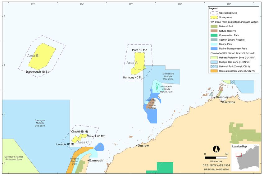
Acoustic energy
                                                                           Dilt float             sources
                                           Hydrophone
                      Tailbuoy              streamers

                                                                                                                             Outgoing
                                                                                                                           acoustic pulse
                         Reflected
                         acoustic
                          energy

                                                                                                                                         Different sub-
                                                                                                                                         surface layers

    ABOUT MARINE SEISMIC SURVEYS
    Marine seismic surveys use acoustic                      tape or disc packs and data processers                    pulses while monitoring the area to be
    or noise pulses to image subsurface                      using powerful computers translate the                    sure no whales are present.
    formations. This is done by transmitting                 information into digital images or maps
                                                                                                                       For the period of seismic operations,
    sound waves that reflect off underground                 of the subsurface. Geophysicists and
                                                                                                                       marine fauna observers on board
    rock formations. The sound waves that                    geologists then analyse and interpret
                                                                                                                       the vessel and during daylight hours
    reflect back are captured by recording                   this data to determine the presence
                                                                                                                       continuously scan for marine life.
    sensors called hydrophones.                              of hydrocarbons or monitor how
                                                                                                                       If whales are detected within close
                                                             hydrocarbon reservoirs change over time.
    The information gathered by the                                                                                    vicinity, operations cease and are only
    hydrophones is collected, converted                      During a seismic survey, standard                         restarted when the animals have
    to a digital signal and relayed to data                  environmental procedures are followed,                    moved away.
    storage devices on the survey vessel. The                including a soft start of the noise pulses,
    data is typically transferred to shore via               gradually increasing the intensity of the

2  North-west Australia 4D Marine Seismic Survey | Exmouth Plateau Sub-basin | Northern Carnarvon Basin | April 2019
Area A                             Area B                                    Area C
                                              Pluto 4D M2          Harmony 4D M1        Scarborough 4D B1      Laverda 4D M1          Cimatti 4D M1        Vincent 4D M2
   Earliest commencement date                      Q4 2019                  Q1 2020           Q1-Q2 2020          Q1-Q2 2020            Q1-Q2 2020            Q1-Q2 2020
   Estimated duration                              28 days            20 to 23 days               45 days           12-13 days               11 days              23 days
   Acquisition Area                                780 km2                  469 km2             2,059 km2              144 km2               87 km2                82 km2
   Operational Area                               3,710 km2               2,419 km2             5,597 km2            1,758 km2             1,564 km2             1,655 km2
   Water depth in Operational area             41 – 1,382 m             39 – 1,195 m         961 – 1,242 m       205 – 1,198 m         183 – 1,028 m          153 – 983 m
   Last acquired data                                  2015                     2013                 2004                 2010                 2010                  2010
   Distance from Acquisition Area       163 km north-west        160 km north-west      357 km north-west    49 km north-west      47 km north-west    51 km north-west of
   to nearest port/marina                      of Dampier               of Dampier             of Dampier         of Exmouth            of Exmouth               Exmouth

   Distance from Acquisition Area      Overlaps north-west      Overlaps north-west        68 km north of         3 km east of     14 km north-west         21 km north of
   to nearest marine park              corner of Montebello     corner of Montebello     Gascoyne Marine      Gascoyne Marine     of Ningaloo Marine      Ningaloo Marine
                                        Marine Park Multiple     Marine Park Multiple    Park Multiple Use   Park Mulitiple Use                Park                  Park
                                                  Use Zone                 Use Zone                  Zone                 Zone

 Proposed activity                                             to show how reservoir characteristics have              Communications with Mariners
 The proposed surveys will be conducted by a                   changed over time. This change or difference
 purpose-built seismic vessel, using technical                 in the seismic signal is known as time-lapse or         A 500 m ‘safe navigation area’ will be in place
 methods and procedures commonly used                          ‘4D’ seismic.                                           around the primary vessel and streamers
 in Australian waters. No unique or unusual                                                                            during seismic operations.
 equipment or operations are proposed.                         The seismic vessel will tow between 6 to 12
                                                               solid streamers at a depth of approximately             The seismic vessels will be operating within
 During the proposed activities, the seismic                   15-18 m with a spacing between streamers of             the Operational Areas determined for these
 vessel will traverse a series of pre-determined               50-100 m and a maximum streamer length of               activities. Marine notices will be issued prior to
 sail lines within each survey Acquisition Area                approximately 8,000 m. Survey activities will           the start of work to alert vessels that maybe
 at a speed of approximately 7-9 km/hr. An                     take place during the day and night.                    operating in waters nearby and that access to
 additional buffer area, or Operational Area, is                                                                       these areas may be limited.
 allowed for vessel manoeuvring. Bubble tests,                 It is anticipated that three project vessels,
 soft starts and seismic line ‘run in’ and ‘run out’           comprising the seismic vessel and up to two             Woodside will provide updates on vessel
 data will be acquired in the Operational Areas.               support and chase vessels will be required for          movements and their details during the
                                                               the surveys in Areas A and B. An additional             activities at an appropriate frequency to meet
 As the vessel travels along the survey lines a                source vessel may be required for surveys               relevant stakeholder needs
 series of noise pulses will be directed every                 in Area C. During this time the main seismic
 6-9 seconds down through the water column                     vessel will be used to tow streamers.
 and the seabed.
                                                               Support and chase vessels will assist with
 The released sound will be attenuated and                     re-supply, refuelling and other support
 reflected at geological boundaries, with                      functions, as well as be on stand-by to manage
 the reflected signals detected by sensitive                   potential interactions with other marine users
 microphones called ‘hydrophones receivers’,                   of the area.
 embedded within a number of cables, or
 streamers, towed behind the seismic vessel.

 The reflected sound will then be processed
 to generate a three dimensional (3D) seismic
 image, providing information about the
 structure and composition of geological
 formations below the seabed.

 The seismic vessel will follow as accurately
 as possible the previous source and receiver
 locations along pre-determined vessel sail
 lines, as acquired by previous surveys in order

3  North-west Australia 4D Marine Seismic Survey | Exmouth Plateau Sub-basin | Northern Carnarvon Basin | April 2019
Survey Coordinates
Area A
Latitude Longitude
19°34'12.462"S 114°56'01.581"E
20°00'11.867"S 114°51'27.323"E
20°18'50.759"S 114°51'27.693"E
Survey Operational Area 20°19'02.669"S 115°08'49.012"E
20°15'53.34"S 115°15'55.885"E
20°02'46.041"S 115°26'26.19"E
19°34'30.004"S 115°24'54.989"E
Pluto 4D M2 survey Harmony 4D M1 survey
Latitude Longitude Latitude Longitude
19°44'02.451"S 115°04'37.853"E 20°10'49.14"S 115°00'04.08"E
20°04'37.104"S 115°04'37.946"E 20°10'53.22"S 115°06'11.94"E
20°04'39.019"S 115°16'23.684"E 20°02'52.542"S 115°18'35.669"E
Survey Acquisition Area
19°44'11.842"S 115°16'28.804"E 19°58'18.234"S 115°15'08.425"E
19°58'17.94"S 115°09'38.28"E
20°04'29.34"S 115°00'03.6"E
Area B
Latitude Longitude
19°23'08.078"S 113°10'55.817"E
19°35'25.579"S 113°39'22.485"E
20°06'02.861"S 113°23'11.159"E
Survey Operational Area
20°14'43.528"S 113°05'50.122"E
20°04'07.021"S 112°41'50.389"E
19°31'10.437"S 112°58'49.251"E
Scarborough 4D B1 survey
Latitude Longitude
19°32'26.998"S 113°11'49.708"E
19°39'19.852"S 113°27'44.143"E
20°00'05.432"S 113°16'44.265"E
Survey Acquisition Area
20°05'39.844"S 113°05'35.852"E
20°00'16.217"S 112°53'23.022"E
19°36'37.046"S 113°05'32.964"E
Area C
Latitude Longitude
21°12'56.728"S 113°53'22.29"E
21°14'36.163"S 113°50'07.552"E
21°34'15.565"S 113°34'45.669"E
21°45'48.511"S 113°51'38.324"E
Survey Operational Area
21°39'48.312"S 114°00'06.655"E
21°39'49.318"S 114°03'34.487"E
21°36'39.407"S 114°10'00.881"E
21°16'24.45"S 114°20'31.463"E
Laverda 4D M1 survey Cimatti 4D M1 survey Vincent 4D M2 survey
Latitude Longitude Latitude Longitude Latitude Longitude
21°29'00.941"S 113°56'29.805"E 21°31'33.609"S 113°54'25.865"E 21°24'12.065"S 114°00'45.066"E
21°35'34.453"S 113°51'22.652"E 21°23'39.518"S 113°58'00.971"E 21°28'19.742"S 113°58'24.633"E
Survey Acquisition Area
21°32'30.412"S 113°46'53.538"E 21°24'50.059"S 114°00'56.251"E 21°28'26.392"S 114°04'38.121"E
21°25'57.047"S 113°52'00.747"E 21°32'45.166"S 113°57'20.863"E 21°24'18.387"S 114°06'47.17"E
4 North-west Australia 4D Marine Seismic Survey | Exmouth Plateau Sub-basin | Northern Carnarvon Basin | April 2019Implications for Stakeholders
In support of the proposed activities, Woodside has undertaken an assessment A number of mitigation and management
Woodside will consult relevant stakeholders to identify potential risks to the marine measures will be implemented and are
whose interests, functions, and activities may environment and relevant stakeholders, summarised below. Further details will be
be affected by the proposed activities. We considering timing, duration, location and provided in the Environment Plan.
will also keep other stakeholders who have potential impacts arising from the North-west
identified an interest informed about our Australia 4D Marine Seismic Survey.
planned activities.
Summary of key risks and/or impacts and management measures.
Potential Risk and/or Impact Mitigation and/or Management Measure
Planned Activities
Interests of relevant stakeholders ++ Consultation with petroleum titleholders, commercial fishers and their representative organisations,
with respect to: and government departments and agencies to inform decision making for the proposed activity and
++ Defence activities development of the Environment Plan.
++ Petroleum activities ++ Advice to relevant stakeholders prior to the commencement of activities.
++ Commercial fishing activities ++ Ongoing consultation by way of updates on vessel movements during survey activities at a frequency to
++ Shipping activities meet relevant stakeholder needs.
Marine fauna interactions ++ Measures will be taken to protect marine fauna and ecosystems from vessel activities and to prevent vessel
collisions and groundings.
++ Maintaining dedicated marine fauna observers throughout the survey.
++ All marine fauna sightings are recorded and reported to the Department of the Environment and Energy.
Marine discharges ++ All routine marine discharges will be managed according to legislative and regulatory requirements and
Woodside’s Environmental Performance Standards where applicable.
Underwater noise ++ Implementation of Environment Protection and Biodiversity Conservation Act 1999 (EPBC Act) Policy Statement 2.1.
++ Noise modelling to inform potential impacts and input to mitigation and management measures.
Vessel interaction ++ Woodside will notify relevant fishery stakeholders and Government maritime safety agencies of specific start
and end dates, specific vessel-on-location dates and any exclusion zones prior to commencement of the activity.
++ A 500 m radius safe navigation area will be in place around the seismic vessel and streamers during
seismic operations.
++ The seismic vessel will display appropriate day shapes and lights to indicate the vessel is towing and is
therefore restricted in its ability to manoeuvre.
++ The streamers will tow surface tail buoys fitted with radar reflectors.
++ A visual and radar watch will be maintained on the project vessel bridges at all times.
++ Support and chase vessels will be on standby to direct any shipping traffic or commercial fishing vessels
away from the seismic vessel and its towed equipment.
Waste generation ++ Waste generated on the vessels will be managed in accordance with legislative requirements and a Waste
Management Plan.
++ Wastes will be managed and disposed of in a safe and environmentally responsible manner that prevents
accidental loss to the environment.
++ Wastes transported onshore will be sent to appropriate recycling or disposal facilities by a licensed waste contractor.
Unplanned
Hydrocarbon release ++ Appropriate spill response plans, equipment and materials will be in place and maintained.
++ Appropriate refuelling procedures and equipment will be used to prevent spills to the marine environment.
Introduction of invasive marine ++ All vessels will be assessed and managed as appropriate to prevent the introduction of invasive marine
species species.
++ Compliance with Australian biosecurity requirements and guidance.
++ Contracted vessels comply with Australian ballast water requirements.
Providing feedback
Our intent is to minimise environmental and social impacts associated with Please note under new public transparency arrangements being implemented by
the proposed activities, and we are seeking any interest or comments you NOPSEMA, the Environment Plan for this activity will be published in full following
acceptance by the Authority. Please advise Woodside if you do not wish any part of your
may have to inform our decision making.
feedback to be published and we will ensure it is included in the sensitive information part
An Environment Plan for the proposed activity will be submitted to the of the Environment Plan. The information received will form part of the EP assessment
however it will not be released publicly and will remain confidential to NOPSEMA
National Offshore Petroleum Safety and Environmental Management Authority throughout.
(NOPSEMA) for acceptance in accordance with the Offshore Petroleum and
Greenhouse Gas Storage (Environment) Regulations 2009 (Cth). Andrew Winter, Corporate Affairs Adviser
Woodside Energy Ltd
If you would like to comment on the proposed activities outlined in this E: Feedback@woodside.com.au | Toll free: 1800 442 977
information sheet, or would like additional information, please contact
Woodside before COB 3 May 2019. Please note that stakeholder feedback will be communicated to NOPSEMA as required
under legislation. Woodside will communicate any material changes to the proposed
activity to affected stakeholders as they arise.
www.woodside.com.au
5 North-west Australia 4D Marine Seismic Survey | Exmouth Plateau Sub-basin | Northern Carnarvon Basin | April 2019You can also read