On the Advantages of Multiple Stereo Vision Camera Designs for Autonomous Drone Navigation
←
→
Page content transcription
If your browser does not render page correctly, please read the page content below
On the Advantages of Multiple Stereo Vision Camera Designs for
Autonomous Drone Navigation
Rui Pimentel de Figueiredo, Jakob Grimm Hansen, Jonas Le Fevre, Martim Brandão, Erdal Kayacan
Abstract— In this work we showcase the design and as-
sessment of the performance of a multi-camera UAV, when
coupled with state-of-the-art planning and mapping algorithms
for autonomous navigation. The system leverages state-of-the-
art receding horizon exploration techniques for Next-Best-View
arXiv:2105.12691v1 [cs.RO] 26 May 2021
(NBV) planning with 3D and semantic information, provided
by a reconfigurable multi stereo camera system. We employ
our approaches in an autonomous drone-based inspection task
and evaluate them in an autonomous exploration and mapping
scenario. We discuss the advantages and limitations of using
multi stereo camera flying systems, and the trade-off between
number of cameras and mapping performance.
I. I NTRODUCTION
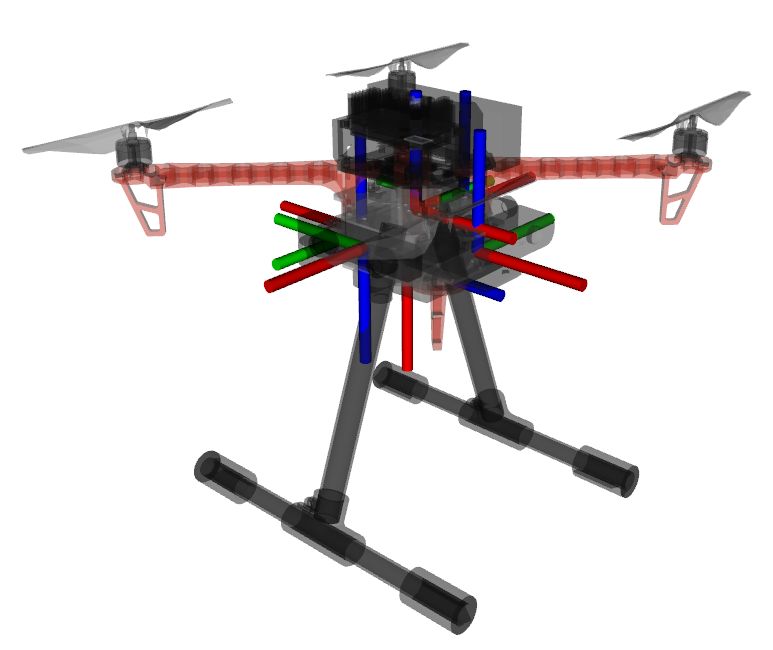
Unmanned aerial vehicles (UAVs) deployed in everyday (a) Multi Stereo Camera UAV CAD design
environments are facing increasingly complex scenarios and
tasks. The problem of selecting which regions of the sur-
rounding environment to attend to during visual exploration,
search, and mapping tasks is computationally and energeti-
cally demanding. Therefore, UAVs should be endowed with
efficient active perception mechanisms that allow them to
attend to objects of interest while avoiding processing irrele-
vant sensory information. Furthermore, the design of systems
with perceptual redundancy are of utmost importance in (b) RGBD (c) Semantics
order to ensure safety and robustness to failures, since Fig. 1: The proposed multi stereo camera UAV platform
sensor arrays can significantly improve perceptual coverage, for autonomous drone navigation applications. The design
task-execution speed, and overall state estimation accuracy. allows to easily attaching a total of 5 stereo vision cameras
Hence, the designer of the robotic system should carefully around the UAV frame (i.e. front, left, right, back, bottom).
select an appropriate number and type of sensors, taking
into account task performance as well as on-board resource-
constraints. High perceptual coverage for safe navigation RRT planning algorithm that leverages both semantic and
and mapping of real world scenarios can be achieved us- metric information for autonomous visual data collection.
ing a flying drone vehicle equipped with vision and IMU Our target application is the inspection of man-made struc-
systems. Using multiple cameras and IMUs offers a robust tures, requiring minimal human intervention. Throughout
solution. However, it comes at the cost of increased payload, the rest of this article we overview the proposed system
and additional computational power and processing-time design and perform an evaluation of the advantages and
requirements. In this work we asses the viability of multi- disadvantages of using multi-camera systems using UAVs,
stereo-camera UAV (see Fig. 1) for autonomous inspection from a computational and mapping performance perspective.
tasks, combining state-of-the-art simultaneous localization This work assesses the former problem trade-offs on an UAV-
and mapping (SLAM) techniques, with cost-efficient NBV based exploration and mapping scenario.
exploration algorithms [1], to geometrically reconstruct and
label all objects in man-made environments. Our navigation II. M ETHODOLOGY
system is targeted at multi-camera UAVs, includes proba- In the rest of this section we describe the proposed
bilistic semantic-metric mapping representations, and uses a multi-stereo-camera system and methodologies for active
exploration and semantic-metric mapping of man-made in-
R. Figueiredo, J. Hansen, J. Fevre, E. Kayacan are with Artificial frastructures.
Intelligence in Robotics Laboratory (Air Lab), the Department of Electrical
and Computer Engineering, Aarhus University, 8000 Aarhus C, Denmark A. System Overview
{rui,jakob,jonas.le.fevre,erdal} at ece.au.dk
M. Brandao is with King’s College London (KCL), London, UK The proposed system for autonomous navigation tasks
{martim.brandao} at kcl.ac.uk consists of a UAV specifically designed for mapping tasks,
Sensors Perception Belief Manager Planning Semantic Aware Navigation
Stereo Visual
IMU 1 Inertial Sparse SLAM
camera 1
Odometry
Map
(...) (...) Geometric and Semantic
Geometric
Aware NBV Planning
3D Semantic
Stereo Segmentation Semantic
IMU N
camera N
Fig. 2: Overview of the proposed autonomous navigation system for localization and semantic-metric mapping of man-made
environments.
that comprises multiple cameras, Inertial Motion Units pc (u, v) ∈ P Kc over the set of known classes C, where Kc
(IMUs), and an altimeter. Our navigation system relies on represents the number of known classes. For training the
an off-the-shelf SLAM system with loop closing and relo- network we use a combination of real and simulated (AirSim)
calization capabilities [2], which is fed with RGB-D data annotated datasets, and the categorical Cross-Entropy loss
provided by user-selected cameras and IMUs measurements. function. At run-time, the semantic probability distribution
These are fused using an extended Kalman filter (EKF) for over all classes and image pixels is merged with the corre-
improved robustness on self-motion tracking performance.In sponding depth image to obtain a semantically labeled point
the proposed hardware design we attempt to minimize weight cloud, using a known extrinsic calibration parametric model.
to achieve better flight performance and flight duration until
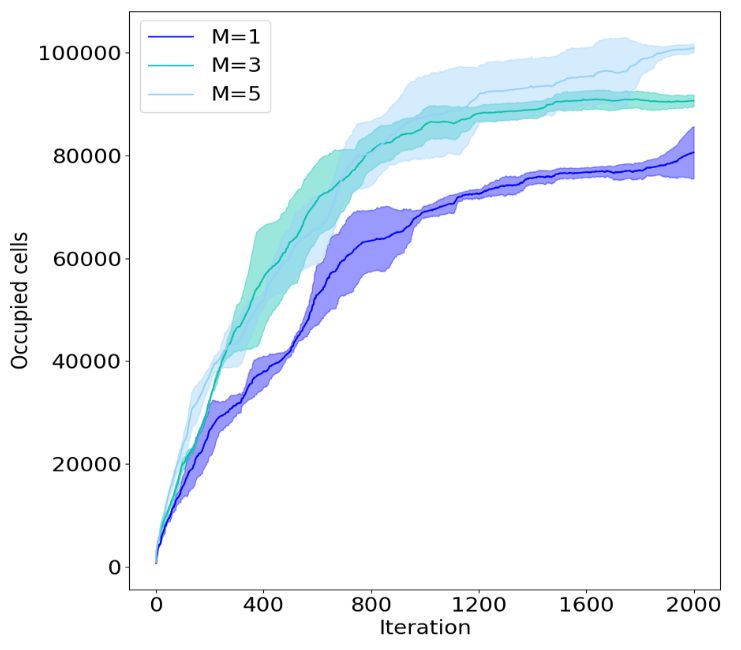
III. R ESULTS
battery depletion, while at the same time minimizing the
size of the parts to avoid vibrations, and ensure camera A. Multi-camera Navigation System
sensors can be placed in orthogonal directions to maximize In order to be able to quantitatively and qualitatively
visual coverage. Our model adds camera sensors to the measure the performance of the proposed mapping and
quad base frame (DJI F450), together with a battery mount planning approaches, a realistic shipyard environment (see
for easy battery replacement. We use Jetson Xavier NX as Fig. 3a) was created using the Gazebo simulator [5]. The
our on-board computer and the Pixhawk 4 as the low-level environment consists of a dry-dock. An intelligent active
flight controller. Furthermore, the system comprises a set of mapping algorithm should maximize task-related rewards, in
stereo-camera sensors (Zed 2 and Mini cameras) suitable for this case information gathering, by focusing on rewarding
visuo-inertial based navigation which are rigidly attached to viewing directions. In each experiment we let the observer
the UAV body base frame, and whose poses are assumed collect T = 2000 observations (i.e.sense, plan and act iter-
deterministically known with respect to the base frame, from ations). Each experiment was repeated 10 times to average
the kinematics model. out variability in different simulations, due to the randomized
nature of our algorithm, and non-systematic errors influenced
1) Multi-camera Navigation System: We rely on a proba- by multiple simulation factors.
bilistic observation model that combines metric and semantic We first analyzed the influence of different camera setups
visual cues, which are efficiently fused in a volumetric in the trade-off between reconstruction accuracy, planning,
octogrid structure [3], and a NBV planner that leverages and run-time performance. For the number of cameras,
both geometric and semantic information for task-dependent we considered M ∈ {1; 3; 5}. Fig. 3 demonstrates the
exploration. We use an octomap representation and recursive advantages of utilizing multiple cameras placed around the
Bayesian volumetric mappingto sequentially estimate the UAV. For this particular scenario, on average, the use of
posterior probability distribution over the map, given sensor multiple cameras not only improves occupancy but also the
measurements and sensor poses obtained through the robot time-to-full-coverage. However, the cameras placed on the
kinematics model and an off-the-shelf SLAM module. Our back and bottom provide lower long-term information when
method for semantic segmentation relies on a Deep Convolu- compared to the front and lateral cameras, since most of the
tional Neural Network (DCNN) encoder-decoder segmenta- surrounding environment is covered by the latter while the
tion network, that receives RGB or grayscale images as input, system is moving.
and outputs a probability distribution over the known object
categories for each pixel (u, v). We use BiseNet [4] because B. Multi-Camera Drone Hardware Design
it is compact, fast, robust and easy to use, being suitable for In order to select the most suitable camera configuration
remote sensing applications running on embedded systems for our autonomous flying system, we measured battery
(e.g. UAVs) with low computational specifications. For each power consumption and time-to-full-coverage across multi-
pixel (u, v), the network outputs a probability distribution ple designs (i.e. different number of sensors) while hovering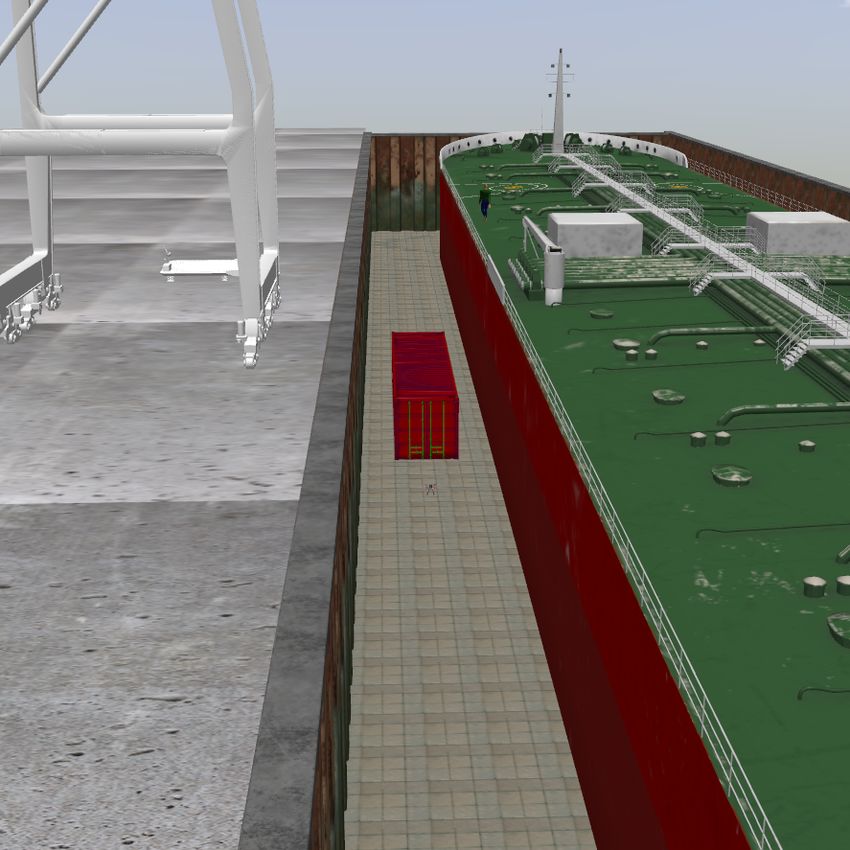
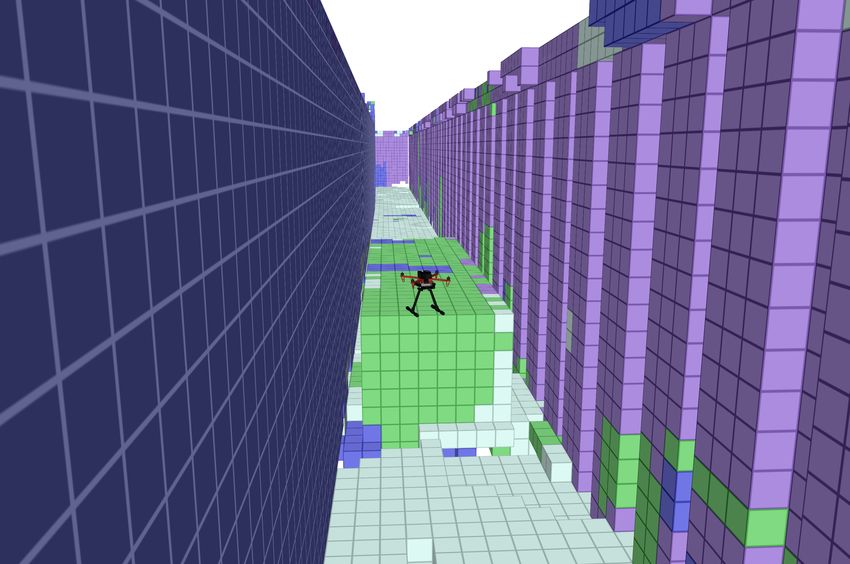
(a) Dry-dock gazebo envi- (b) Octomap is colored accord-
  ronment.                  ing to most likely semantics.

                                                                               Fig. 4: Battery consumption profile.

                                                                      Cameras           M =1             M =3              M =5
                                                                     Flight Time      8.79 ± 0.86      8.17 ± 0.41       6.00 ± 0.99
                                                                TABLE I: Hovering time until battery depletion (minutes).

                                                                computation requirements and flight-time duration, in a real
                                                                experimental setup. In the future we intend to improve the
                                                                proposed multi-camera approach with the ability to schedule
     (c) Evolution of the average number of occupied cells.     sensor acquisition such as to decrease computational load
Fig. 3: Mapping performance temporal evolution of our multi     and power consumption.
stereo camera system in a realistic simulation environment.
                                                                                        ACKNOWLEDGMENT
                                                                   The authors would like to acknowledge the financial con-
the real UAV with a different number of cameras (for 5          tribution from Smart Industry Program (European Regional
different runs). As can be seen in Fig. 4, the power consump-   Development Fund and Region Midtjylland, grant no.: RFM-
tion (proportional to lithium battery voltage) increases with   17-0020). The authors would further like to thank Upteko
the number of cameras since they increase both the weight       Aps for bringing use-case challenges.
and processing requirements of the system. Hence, although
higher visibility and faster coverage can be achieved with                                   R EFERENCES
more cameras (M = 5), when considering power constraints        [1] A. Bircher, M. Kamel, K. Alexis, H. Oleynikova, and R. Siegwart, “Re-
and flight duration (Table. I), M = 3 is a more appropriate         ceding horizon path planning for 3d exploration and surface inspection,”
                                                                    Autonomous Robots, vol. 42, no. 2, pp. 291–306, 2018.
design choice for this use-case.                                [2] R. Mur-Artal and J. D. Tardós, “ORB-SLAM2: an open-source SLAM
                     IV. C ONCLUSIONS                               system for monocular, stereo and RGB-D cameras,” IEEE Transactions
                                                                    on Robotics, vol. 33, no. 5, pp. 1255–1262, 2017.
   In this work we have proposed and assessed multi-stereo-     [3] A. Hornung, K. M. Wurm, M. Bennewitz, C. Stachniss, and W. Burgard,
vision camera setups for autonomous navigation of UAVs              “Octomap: An efficient probabilistic 3d mapping framework based on
that incorporates probabilistic semantic-metric mapping rep-        octrees,” Autonomous Robots, vol. 34, no. 3, pp. 189–206, 2013.
                                                                [4] C. Yu, J. Wang, C. Peng, C. Gao, G. Yu, and N. Sang, “Bisenet:
resentations, for semantically-aware NBVs planning. We              Bilateral segmentation network for real-time semantic segmentation,”
assessed the proposed designs and methodology on a realistic        CoRR, 2018.
simulation environment (Gazebo), and evaluated the trade-       [5] N. Koenig and A. Howard, “Design and use paradigms for gazebo,
                                                                    an open-source multi-robot simulator,” in 2004 IEEE/RSJ International
offs of using multi-camera navigation systems in UAV-based          Conference on Intelligent Robots and Systems (IROS), vol. 3, 2004, pp.
inspection tasks. Our final design choice considered power,         2149–2154 vol.3.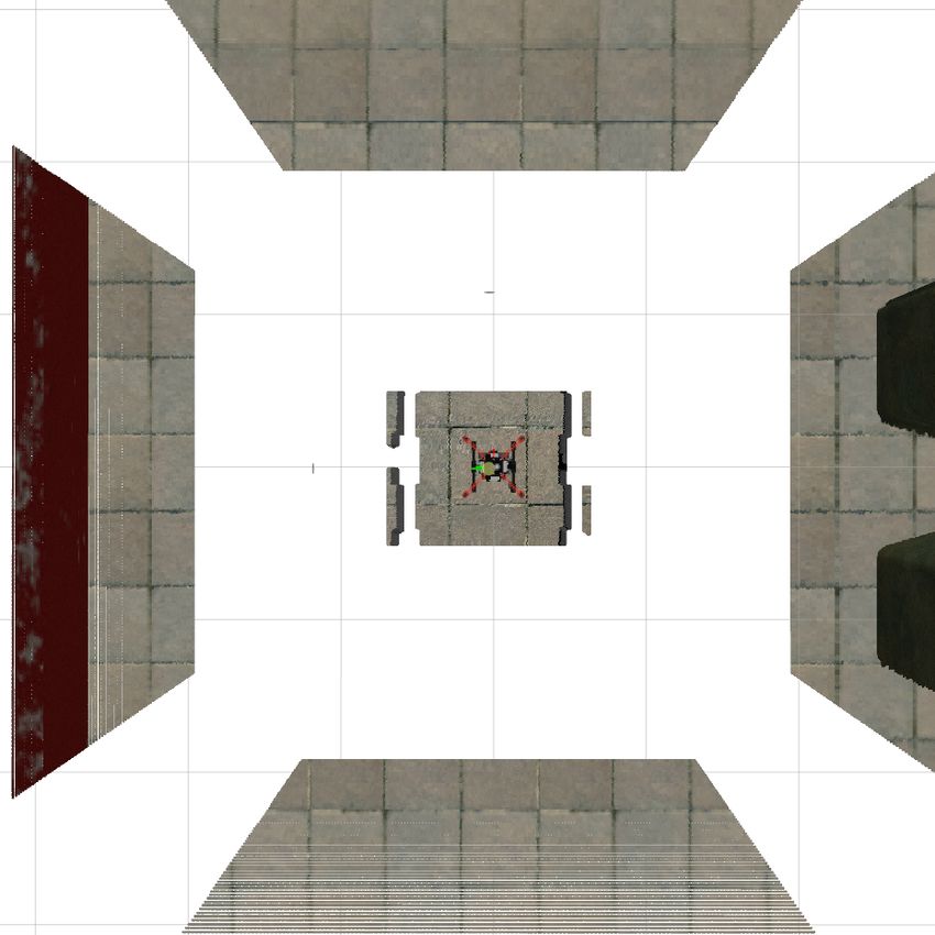
You can also read