OpenBuildingModels - Towards a Platform for Crowdsourcing Virtual 3D Cities
←
→
Page content transcription
If your browser does not render page correctly, please read the page content below
OpenBuildingModels - Towards a Platform for
Crowdsourcing Virtual 3D Cities

Matthias Uden1, Alexander Zipf

   Chair of GIScience, Department of Geography, University of Heidelberg, Berliner Straße 48,
   69120 Heidelberg, Germany
   {uden, zipf}@uni-heidelberg.de

Abstract Within the last years, Volunteered Geographic Information (VGI) has
developed rapidly and influenced the world of GIScience significantly. Most
prominently, the OpenStreetMap (OSM) project maps our world in a detail never
seen before in user-generated maps. Particularly within urban areas, the focus re-
cently shifts from only streets towards buildings and other objects of the environ-
ment such as parks or street furniture. However, this innovation is mostly re-
stricted to 2D so far. In order to come closer to the Digital Earth, it needs to be
discussed, how the 3D aspect can be integrated into such VGI-projects. This arti-
cle has two objectives that are closely related: firstly, the current situation of 3D-
VGI is reviewed and crucial issues for future development are pointed out. This
leads to the concept of defining a free and open web repository for architectural
3D building models. Therefore secondly, the concept of such a new web platform
called OpenBuildingModels is presented. This is an important effort towards 3D-
VGI. The models can be linked to OSM objects and displayed by a dedicated 3D
viewer. This can extend the possibilities to crowdsource 3D city models in the fu-
ture.

Keywords: Volunteered Geographic Information, OpenStreetMap, 3D city mod-
els, 3D spatial data infrastructures, 3D building modelling

1 Introduction

It's now been over four years that Goodchild (2007) has introduced the term "Vol-
unteered Geographic Information" (VGI) describing the recent revolution of col-
laboratively created spatial information on the Web 2.0. The increasing availabil-
ity of smartphones as devices for creating, using and sharing geoinformation
spatially enables our society more and more (cf. Williamson et al. 2011). This
leads to an ever growing amount of various VGI-related activities which also have

   1   Corresponding Author.
2      Matthias Uden, Alexander Zipf

an impact on research in geographic information science (e.g. WikiMapia 2012;
Cloudmade 2012; Panoramio 2012).
    The most popular and successful VGI project is probably OpenStreetMap 2
(OSM). Recent investigations on its completeness and quality have shown, that in
particular urban areas in Central Europe have already been mapped with an im-
pressive level of detail (cf. Haklay 2010; Neis et al. 2012). In those areas, OSM is
meanwhile well ahead of only mapping the street network. For a continuous im-
provement of OSM it is crucial to enable the mapping of even more detailed,
three-dimensional spatial information.
    Another phenomenon which is rapidly gaining relevance over the last decade
not only in the geo-domain but also in the general public is 3D city models. This
has been an important research field in GIScience since a couple of years now (cf.
Förstner 1999; Früh and Zakhor 2004; Kolbe 2009). Furthermore, numerous ef-
forts exist from both companies (e.g. Google 2012) as well as public administra-
tions (e.g. Stadtmessungsamt 2012). The era of mapping the Digital Earth (Gore
1998) in three dimensions has long begun. Based on the recent developments in
VGI it now becomes possible to investigate the potential of applying crowdsourc-
ing also to 3D geodata.
    The dominant parts of 3D city models are buildings. In early 2012, the total
number of mapped building footprints in OSM exceeded 50 million3. It even sur-
passed the number of mapped streets. This shows the gradual shift in the purpose
of this project, which is no longer limited to only the streets but also includes
buildings and other components of urban environments. However, the footprint is
only a very rough representation of a building and much more information lies in
its detailed 3D structure. The idea of letting the crowd assemble comprehensive
3D city models is very promising.
    This paper firstly examines the current state and future directions of user-
generated 3D spatial information. Secondly, the concept of OpenBuildingModels,
one possible way of how to advance 3D-VGI, is introduced thereafter. We investi-
gate the following questions: How can the potential of VGI be exploited for gen-
erating 3D city models beyond what has been reached so far? What are the main
scientific and practical questions and problems in this leap forward from 2D to 3D
with respect to crowdsourcing? What are the means to enable voluntary users to
contribute rich 3D information?
    The remainder of this paper is structured as follows: the review part starts in
chapter 2 with related work on user-generated spatial 3D content. Subsequently,
the current situation of 3D-VGI is critically reflected and crucial issues for the fu-
ture development are pointed out. In chapter 3, the concept and a first prototype of
OpenBuildingModels (OBM) is described. Furthermore, a discussion of advan-
tages and drawbacks of the OBM approach as well as the implemented prototype
is given. The last chapter summarises important aspects of this article, pointing out
the main insights and limitations as well as potential future work.

2   http://www.openstreetmap.org
3   extracted from our internal, regularly updated OSM database
OpenBuildingModels - Towards a Platform for Crowdsourcing Virtual 3D Cities   3

2 The 3D aspect in VGI

2.1 Related Work

Letting the crowd generate spatial 3D information is still in its early stages, how-
ever, the idea is not entirely new. This section contains related work which deals
with this topic, approaching it from different directions.
    One of the most prominent examples is Google's 3D Warehouse4. This shared
repository contains user-generated 3D models of both geo-referenced real-world
objects such as churches or stadiums and non-geo-referenced prototypical objects
like trees, light posts or interior objects like furniture. The former also appear in
Google Earth. In order to voluntarily contribute, users have to have a certain level
of 3D modelling skill. The main focus of this repository does not lie on assem-
bling 3D city models as the non-geo-referenced objects seem to be more important
in related work. They are for example used to improve methods of automatic ob-
ject recognition in the field of laser scan classification (Lai and Fox 2009) or ro-
botic vision (Klank et al. 2009). Also, the 3D warehouse models are being inte-
grated in several commercial systems like design tools (RenderLights 2012) or
simulation software (Simio 2012).
    Google also developed the Building Maker5, which provides a model kit to cre-
ate buildings, deriving the 3D geometry from a set of oblique (and proprietary)
birds-eye images of the same object from different perspectives. In contrast to the
3D Warehouse, this tool specifically aims at geo-referenced 3D building models
only. It is intended for people who do not have knowledge in 3D modelling, but
still want to contribute. Willmes et al. (2010) and Yiakoumettis et al. (2010) have
demonstrated, how this tool can be used to create 3D buildings rather quickly,
even of an entire university campus. Drawbacks are the potentially inaccurate
modelling due to image errors or obstructions, the current little availability of the
required oblique aerial imagery as well as limited usage of the result due to restric-
tions of Google’s proprietary data.
    Even though both introduced methods are based on collaboratively collected
data, it is Google who stands behind it and claims usage and distribution rights for
the contributed contents. Hence, this is far away from being open source or open
data. However, there are also numerous free-to-use 3D object repositories on the
internet, for example OpenSceneryX6, Archive3D7 or Shapeways8. These projects
emerged from entirely different communities with interest in e.g. flight simulators

4 http://sketchup.google.com/3dwh
5 http://sketchup.google.com/3dwh/buildingmaker.html
6 http://www.opensceneryx.com

7 http://www.archive3d.net

8 http://www.shapeways.com
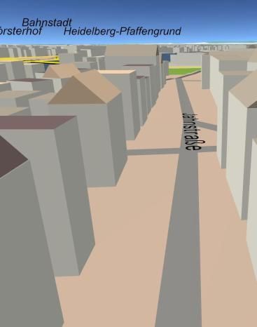
4    Matthias Uden, Alexander Zipf

or 3D printing. The contents usually lack the connection to the real-world but can
nonetheless also be useful to enrich real 3D city model visualisations.
   More and more ideas for collaboratively mapping the third dimension are also
being discussed recently in the OpenStreetMap community. Several approaches
exist which basically all try to utilise the crowdsourced data for deriving 3D city
models from it.
   The OSM2World9 software takes into account various 3D-related information
that is available, such as the building height or the basic roof shape. It offers dif-
ferent export possibilities like .obj-files, direct output via an OpenGL binding for
Java (JOGL) or a .pov-file for the persistence of vision10 raytracer. It also experi-
ments with the integration of terrain data from a Digital Elevation Model (DEM),
however, this is currently still under development. Also, an easy-accessible web or
desktop interface or standardisation of output formats is missing.
   Another example which is intended to support the user in generating 3D data
for OSM is the Kendzi3D plug-in (Kendzi 2011) for the widely used Java Open-
StreetMap-Editor (JOSM) 11 . It directly converts several 3D-related information
into a 3D model during an edit session on the screen, allowing the user to immedi-
ately see the result of their annotation. This makes model creation in the OSM
context much easier. It is, however, still under development and many improve-
ments in usability and the supported 3D-related OSM annotations have to be car-
ried out in the future.
   The most advanced work in the context of creating 3D city models from VGI
data is the OSM-3D project (cf. Over et al. 2010; OSM-3D 2012). It combines the
extrusion of the building footprints into the third dimension with a detailed inte-
grated terrain model derived from SRTM12 height data. It provides the 3D data in
a standardised manner through a Web 3D Service 13 (W3DS), which is currently a
discussion paper at the Open Geospatial Consortium (OGC). At present, the OSM-
3D W3DS supports different terrain generalisation levels and provides tiled 3D
scenes, based on the requested point of view, in VRML, X3D, COLLADA or
KML format. There has also been developed a tailored client software called
XNavigator14, which automatically requests the data from the W3DS server and
assembles complex 3D landscapes worldwide. This client also allows the integra-
tion of other OGC Web Services such as a Web Feature Service (WFS), the
OpenGIS Location Services (OpenLS, Schilling et al. 2009) or the Sensor Obser-
vation Service (SOS, Mayer and Zipf 2009). Thus, for example POIs or 3D routes
can be included. The interoperability with different data sources (e.g. also
CityGML), web services and targets has recently been examined within the OGC

9 http://osm2world.org
10 http://www.povray.org
11 http://josm.openstreetmap.de

12 http://srtm.csi.cgiar.org

13 http://www.w3ds.org

14 http://xnavigator.sourceforge.net
OpenBuildingModels - Towards a Platform for Crowdsourcing Virtual 3D Cities      5

3D Portrayal Interoperability Experiment (3DPIE, OGC 2011). The wide applica-
bility of the W3DS and XNavigator with heterogeneous data could be demon-
strated. Fig. 1 exemplarily shows two scenes of Central Heidelberg rendered in
XNavigator.

                     (a)                                            (b)
Fig. 1 (a) OSM-3D overview of Central Heidelberg in XNavigator. (b) Detailed view of a street
with its buildings

   All these approaches are mainly different available tools in this highly innova-
tive field of 3D volunteered geographic information and only little research on it
exists. Some related work shows, however, that the preconditions for voluntary 3D
data capturing are already mostly fulfilled. With low-cost sensors and cameras
which are often available in today’s smartphones, the acquisition of 3D data be-
comes possible for a wider audience. This allows for example the reconstruction
of 3D objects based on 2D images taken by low-cost sensors (Rocchini et al.
2001; Pomaska 2009; Wang 2011). According to the typical processing workflow
of any geographic data, the capturing is followed by data editing and visualisation.
Research about suitable data structures, modelling techniques and visualisation
strategies in the context of crowdsourced 3D data is strongly needed. While a lot
of research about accurate 3D reconstruction of buildings is available (e.g.
Brenner 2005; Sampath and Shan 2010), all this has to be examined in an alto-
gether different light for the crowdsourced approach. Apart from some work on
3D-VGI within indoor environments (Goetz and Zipf 2012), there is, to the au-
thor’s knowledge, no related scientific work in this area.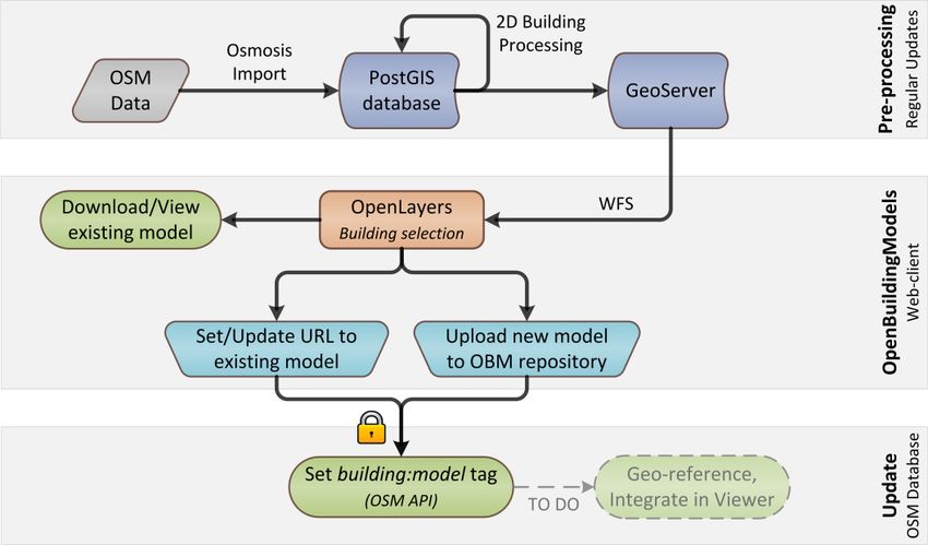
6 Matthias Uden, Alexander Zipf 2.2 Current issues and future directions The previous section shows, that crowdsourced spatial 3D modelling is still a very young and innovative field of research with only little existing research and many open questions. This section will take a closer look at the field of 3D-VGI, inves- tigating current issues and possible future directions more thoroughly. This will be done with a focus on OpenStreetMap, since it is currently the most elaborated platform for crowdsourced geoinformation. Apart from the above mentioned ap- proaches, there are also various other ideas and concepts in the OSM community. Numerous people are working on this topic and lively discussions on how to ad- vance it are taking place (cf. OSM Wiki 2011a). The step from 2D maps to 3D models is not a small one and there exist a lot of issues that have to be tackled. In particular, three main aspects can be pointed out which currently prevent a faster development into the third dimension within OSM: The missing support of 3D geoinformation in the simple OSM data model The lack of a mature and disseminated 3D viewer for OSM The lack of appropriate mechanisms that allow users to contribute various kinds of 3D environmental information with different levels of detail 2.2.1 No suited 3D data model The main issue regarding the first point is that the OSM data model is deliberately kept rather simple in order to attract as many users as possible. It tries to model the world with only nodes, ways and relations. Apart from this geometry, every kind of additional information for a certain feature has to be expressed by so- called tags in the form of key-value pairs (cf. Haklay and Weber 2008). Whilst these tags can in general be freely defined by any user, there exists an agreement on common tag names and values, whose usage is recommended (OSM Wiki 2011b). With this ontology it is possible to semantically annotate many features of our environment. For instance, building footprints can be modelled with closed way geometries which are annotated with the tag building=yes. That is, 3D ge- ometry is not inherently supported in the data model, but can so far only be ex- pressed with appropriate tags. Simple building properties like its height or number of floors can be modelled this way. However, for more complex geometrical fea- tures such as detailed roof structures, dormers or balconies, this approach is se- verely limited. Nevertheless, there are efforts trying to express 3D phenomena with this simple data model. Simple 3D-related tags are partly already being used in OSM (cf. Goetz and Zipf 2012 in press). Also, proposals for appropriate tag- ging schemas for more complex 3D buildings are currently being discussed in the community (cf. Strassenburg-Kleciak 2011). Most of the proposed tags are none- theless only rarely used so far since no consensus on tag-based 3D modelling has been reached yet. One could argue that the basic OSM data model should be ex-
OpenBuildingModels - Towards a Platform for Crowdsourcing Virtual 3D Cities   7

tended to better allow for 3D modelling. However, such a major change is cur-
rently not very likely to be accepted by the community, since there are also people
disapproving of the idea to bring 3D into OSM. It is preferable to find out how far
the approach to build 3D information on top of the simple OSM model brings us
closer to the goal of supporting crowdsourcing 3D, and at which point a different
approach with a dedicated data model is needed.

2.2.2 No widespread 3D viewer

Another reason for the little usage of 3D-related attributes is the absence of a
widespread and established 3D viewer that visualises the 3D data. The appearance
of one's specially created cartographic object on a worldwide available online map
is one of the main motivations why people are committed to the OSM project in
the first place (cf. Coleman et al. 2009). An essential point in order to push for-
ward 3D mapping is therefore the development and dissemination of such a 3D
viewer which displays the objects modelled by the users. If already existing ap-
proaches like OSM-3D or OSM2World are improved and promoted, there will
probably be a boost in the interest of 3D mapping. Without it, it is currently not
surprising that only few people are willing to contribute 3D information, even
though it is already possible to a certain extent.

2.2.3 Not enough support for voluntarily contributing 3D information

Finally, there are currently too little possibilities for the crowd to contribute 3D in-
formation to OSM apart from the aforementioned tag-based modelling. This as-
pect of missing capturing and editing mechanisms will be reviewed more thor-
oughly in the following.
   The range of possible 3D-related information in our environment that could be
mapped by the users is very wide. It starts with simple building characteristics
such as the number of floors, the facade material or a rough roof structure. This in-
formation is easy to obtain by any mapper, neither 3D modelling skills nor spe-
cialised equipment are required, and it is already supported in OSM. However, it
should also be possible to map more details about a 3D object, up to entire archi-
tectural models, and link them to the OSM world. The above mentioned example
of the Google 3D Warehouse has shown that there are people who have the skills
and interest to do this. Accordingly, there should be a wide range of tools and
concepts which support the motivated mapper in contributing various 3D informa-
tion in different levels of detail.
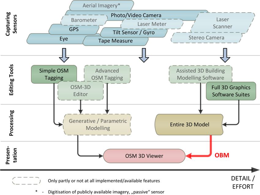
8   Matthias Uden, Alexander Zipf

Fig. 2 Methods for capturing and processing 3D volunteered geographic information for
OpenStreetMap on different levels of detail

   On the top of the diagram in Fig. 2, different sensors are shown with which
spatial 3D information can be obtained by voluntary mappers. Whilst simple
building properties do not require sensors with high accuracy but are simply
measureable with the eye, more complex models can only be created by means of
various sensors such as laser meters, terrestrial and/or aerial imagery, GPS or even
terrestrial laser scanning. Many of these sensors are nowadays included in modern
smartphones, making them a multi-sensor-system which is pretty well-suited for
crowdsourced 3D data capturing. In the future, further sensors like barometers,
stereo cameras (e.g. Microsoft Kinect, cf. Elgan 2011) and maybe also laser me-
ters and little laser scanners will possibly be included into smartphones, making
them even more all-round tools for 3D-VGI.
   Once the data is captured, it needs to be edited. Between simple OSM-tagging
and the creation of entire 3D models with 3D graphics modelling software, there
are further (planned or existing) tools in-between, which support mappers with
different skills and ambitions in terms of the level of detail. For instance, an editor
like the aforementioned Kendzi3D JOSM-plugin (Kendzi 2011), which is special-
ised for advanced OSM 3D-building modelling, makes it easier for the users to as-
semble parametric 3D models without caring about the rather complicated and
cumbersome tagging itself. Such an editor could also avoid incorrect modelling
and ensure topological consistency in complex 3D objects. Besides the manual
creation of entire 3D models with 3D modelling software, there is also the possi-
OpenBuildingModels - Towards a Platform for Crowdsourcing Virtual 3D Cities   9

bility of reconstructing 3D buildings from terrestrial photographs. In research,
many photogrammetric and digital image processing approaches exist (e.g.
Debevec 1996; Müller et al. 2007). This reconstruction could traditionally only be
accomplished with complex and expensive photogrammetrical software systems
such as ERDAS LPS15. However, as already mentioned in chapter 2.1, there re-
cently also emerged free-to-use “assisted” 3D modelling software like Autodesk
123D Catch16 or My3DScanner17 which offer a low-cost alternative for creating
3D models from photographs. This could evolve to an important feature for
crowdsourced 3D modelling.
    There are basically two types of models which emerge from the editing layer:
On the one hand, we get parametric building models, which are based on a geo-
referenced footprint plus various tags and can be generated dynamically by the 3D
viewer. On the other hand, there are finished models, created by dedicated (or as-
sisted) modelling software, which have to be placed properly in the 3D viewer.
Attributes describing their geo-reference and scale are then required.
    The currently available 3D viewers do only partly include the desired function-
ality and flexibility shown in the diagram. Generative modelling based on OSM
tags is currently limited to some simple 3D-related attributes. The possibility to in-
tegrate entire 3D models is in general already available in the OSM-3D viewer
XNavigator (cf. Fig. 3). However, this process includes many difficult steps which
have to be carried out manually. Also, no real link to the OSM database is being
established, nor is the model stored in a publicly available online repository.
Hence, other viewers cannot display this model.

15 http://www.erdas.com/products/LPS/LPS/Details.aspx
16 http://www.123dapp.com/catch
17 http://www.my3dscanner.com
10 Matthias Uden, Alexander Zipf
(a) (b)
Fig. 3 An OSM-3D scene shown in XNavigator without (a) and with (b) a manually integrated
architectural 3D model of a church
Many parts of the diagram in Fig. 2 are visionary and only partly implemented,
if at all. There are a lot of things to be done in order to assist the realisation of VGI
in the third dimension. In this article, we start with a concept for linking entire 3D
models to the OSM database. As Over et al. (2010) mentioned, the development of
a free 3D repository with architectural building models would be a major step
forward.
3 The concept of OpenBuildingModels (OBM)
In this chapter, a first prototype of OpenBuildingModels is introduced. Its objec-
tive is to create a web-based platform for uploading and sharing entire 3D building
models. Many complex buildings like churches or other landmarks cannot be
modelled in detail with a tag-based, parametric approach. Instead, 3D models from
the OBM repository should be linked to OSM, so they can be rendered by OSM
3D viewers subsequently. Thus, crowdsourced 3D city models can be greatly im-
proved.OpenBuildingModels - Towards a Platform for Crowdsourcing Virtual 3D Cities 11 Fig. 4 Workflow of the OpenBuildingModels prototype The processing of the OSM data and set up of a model repository in the first prototype comprises several steps, which are briefly described in the following. The user should be able to interactively choose the building of interest from a map. Therefore, the ground plans first have to be derived from the OSM data sepa- rately and overlaid as vector layer. This is achieved by first importing the OSM data into a PostgreSQL/PostGIS database with the Osmosis tool and converting the closed ways which are tagged as buildings to polygon geometries. Native SQL along with several PostGIS functions is used for this. More complex footprints that contain inner holes and therefore consist of more than one closed way, can also be converted (cf. Goetz and Zipf 2012; Goetz et al. 2012). This conversion step is part of the pre-processing illustrated at the top of Fig. 4. For the provision of the processed building polygons to the web-client, we set up a GeoServer18. The web-client requests the geometries via an OGC-compliant Web Feature Service. 18 http://geoserver.org
12      Matthias Uden, Alexander Zipf

Fig. 5 Screenshot of the OBM web-client. The OSM properties of a building are shown on selec-
tion and a 3D model can be up- or downloaded to our repository

   Fig. 5 shows a screenshot of the current OBM web client. The main component
is an OpenLayers19 map, which shows the building footprints as a vector overlay.
When a building is selected, the client requests general information about the
OSM way with the corresponding ID over the OSM API20 via a HTTP GET re-
quest. The API delivers a small XML file which contains for example the user
who created that geometry and all associated tags (key-value pairs). The XML is
parsed by a PHP script and the information is displayed to the user. Since this op-
eration only reads contents from the database, no OSM authentication is neces-
sary.

19   http://openlayers.org
20   http://api.openstreetmap.org
OpenBuildingModels - Towards a Platform for Crowdsourcing Virtual 3D Cities   13

   The connection of a separately created 3D model with the selected OSM build-
ing is being achieved in the current prototype by simply setting the tag build-
ing:model=URL. When a new building model is uploaded, this tag is set to the
new URL automatically. Alternatively, the user can set or update the URL manu-
ally, if a model for the selected building already exists on some other publicly
available server. For these operations, an OSM user account is required, since new
information is written to the database. If the model-tag is already set for a given
building, it is also possible to directly download the model, e.g. in order to edit it
or convert it to a different format.

4 Discussion

After the technical components of the OBM prototype have been explained, the
general approach as well as the client is reflected critically in the following.
    Linking 3D building models with the OSM database was in general already
possible before by manually setting the building:model-tag and storing the model
on some publicly available server. However, the OBM prototype makes this proc-
ess much easier and integrates building selection and uploading in an interactive
easy-to-use client. Once the models appear in a viewer like OSM-3D, OBM can
potentially attract valuable users from the 3D modelling domain with the neces-
sary skills to build complex models. It is expected, that predominantly complex
landmark buildings will be uploaded to the OBM repository first. This is benefi-
cial, since these kinds of buildings are particularly important for possible applica-
tions like pedestrian navigation. The improved visualisation in the 3D viewer with
enhanced landmark models will lead to better representations of the cities. This
can be seen in Fig. 3b, where the integration of a recognisable, realistic 3D model
of the church is a massive improvement.
    While the 3D visualisation can be greatly enhanced with this approach, it has
also some drawbacks. As good as architectural 3D objects might look, they often
lack topology and semantics, unless they are created in a dedicated format like
CityGML. Apart from an improved visualisation, models without semantic anno-
tation will have only little added value for applications that require semantic, stan-
dardised 3D city models. Similar to existing repositories, users will certainly cre-
ate 3D models of varying complexity. Some might include in their model each and
every detail of the outer structure or also model the interior. Others might create
3D models with a lower level of detail. On top of the entire 3D models, parametric
models based on 3D-OSM-tagging will also exist with varying detail. Hence, one
could generally argue that offering various tools and approaches for contributing
3D information could lead to a rag rug with a low level of standardisation and that
an agreement on only one defined method to map 3D buildings is preferable.
However, such heterogeneous modelling is a general phenomenon inherent in
VGI. The current 2D OSM also consists of many differently mapped features and
the consensus on common mapping techniques is rather low. And this is not nec-
14 Matthias Uden, Alexander Zipf
essarily a drawback, because only this keeps the barrier for beginners as low as
possible. The introduction of mandatory mapping standards for quality assurance
would repel most people from participating and contradict the general idea of the
openness of VGI.
The described client is only a first prototype and there are lots of open issues
that have to be addressed in the future. Fig. 4 indicates the most important next
step: the models have to be geo-referenced in order to place them correctly in the
real world. This could be accomplished by a semi-automatic approach which tries
to reference the object by fitting it into the given OSM footprint first and asks the
user for further manual refinement. In order to ensure a correct alignment between
3D objects and OSM footprints in the first place, it would be helpful to initially of-
fer a download of the existing building outline as a basis for the modelling of a
new building. OBM should support various 3D formats in the future in order to
guarantee a high level of flexibility. At the same time, a 3D viewer has to support
all these formats. This will lead to issues about format conversion and interopera-
bility. Currently, textures are not supported by OBM. Since textures are an essen-
tial part of high-detail building models, this should be made possible in the future.
Another important aspect is the usability of the web client. It is desirable to pro-
vide not only the upload of 3D models for buildings whose footprint is already
part of OSM, but also for such that have not been mapped at all. The user could
properly place the 3D model on the map and the corresponding 2D footprint could
be derived and added to the OSM database automatically. Furthermore, an impor-
tant improvement would certainly be to support models with different levels of de-
tail for the same object. This is currently not possible due to the bijective approach
that only uses the building:model-tag. Also, performance will play a crucial role
once a couple of detailed models will have been added. Ensuring smooth visuali-
sations and efficient storage of the models will be a challenging task due to the
enormous data load.
5 Conclusion & Future Work
In this paper, the current situation of 3D volunteered geographical information
was discussed and a new concept of how to push it forward was introduced with
OpenBuildingModels.
In the first part, a review about related work in this context was given, showing
that besides some available tools, only little research exists in this innovative field.
Subsequently, the current situation was critically discussed and main issues re-
garding further progress in this area were pointed out. In the second part of this ar-
ticle, a basic prototype of OpenBuildingModels was introduced. This approach
aims to build up a free repository of 3D building models which can be linked to
the OSM database. Advantages and shortcomings of this approach were discussed
thereafter. OBM has the potential to attract users with 3D modelling skills to the
geo-domain and the OpenStreetMap project in the future. This is an important stepOpenBuildingModels - Towards a Platform for Crowdsourcing Virtual 3D Cities 15
for the progression of 3D-VGI, because it is impossible to model each and every
building based on the rather low-level data schema of OSM. However, there are
still many challenges to be tackled. Most importantly, these include a correct geo-
referencing of the models. Also, there are many different 3D formats in which the
models can be created and therefore questions regarding the conversion of formats
and interoperability are to be answered as well. Furthermore, issues arise about
how complex 3D models can be effectively edited by multiple users, since this is
not as straightforward as it is for standard 2D map features. The possibility to up-
load multiple models for one object to the repository with different levels of detail
must be considered. Finally, performance as well as effective storage and com-
pression of complex models will be further issues.
A VGI-based approach to 3D city modelling is very promising and can poten-
tially lead to an added-value in this field of application. User-generated ap-
proaches have already proven their potential to be capable of capturing high-
quality spatial information. The interest in 3D mapping is rising in the OSM
community. Since OSM is an established and successful platform, it is currently
most qualified for 3D-VGI, although there are some shortcomings like the rather
unsuitable data model. One key question will be how much 3D is capable and sen-
sible in such a project and when new approaches and platforms are needed. Open-
BuildingModels is one of several possible means to enable voluntary users to con-
tribute rich 3D information. It is a first effort to push forward the 3D mapping and
apart from it, many other possible issues could be tackled in the future. For in-
stance, the tag-based modelling and therefore the parametric building model crea-
tion could be advanced. Dedicated OSM-3D editors have to be developed in order
to make it as easy as possible for inexperienced mappers to contribute 3D infor-
mation. There should be a wide range of mechanisms available to allow crowd-
sourced 3D mapping on different scales. Also, an extension of the OBM reposi-
tory to not only buildings but also other objects of our environment like street
furniture, prototypical landscape objects or the like is conceivable and would lead
to more detailed and usable crowdsourced 3D city models.
Acknowledgments The authors would like to thank all proofreaders who helped to improve
this article and particularly all contributors to the OSM-3D project. This research has been par-
tially funded by the Klaus-Tschira Foundation (KTS) Heidelberg.
References
Brenner C (2005) Building reconstruction from images and laser scanning. International Journal
of Applied Earth Observation and Geoinformation 6 (3-4):187-198
Cloudmade (2012) Application gallery. http://cloudmade.com/application-gallery. Accessed
09/01/201216 Matthias Uden, Alexander Zipf Coleman DJ, Georgiadou Y, Labonte J (2009) Volunteered geographic information: The nature and motivation of produsers. International Journal of Spatial Data Infrastructures Research 4:332-358 Debevec PE (1996) Modeling and rendering architecture from photographs. Dissertation, Unviersity of California, Berkeley, CA Elgan M (2011) Kinect: Microsoft's accidental success story. http://www.computerworld.com/s/article/9217737/Kinect_Microsoft_s_accidental_success_st ory. Accessed 11/01/2012 Förstner W 3d-city models: Automatic and semiautomatic acquisition methods. In: Fritsch D, Spiller R (eds) Photogrammetric Week '99, 1999. Wichmann, Heidelberg, Früh C, Zakhor A (2004) An automated method for large-scale, ground-based city model acquisition. International Journal of Computer Vision 60 (1):5-24. doi:10.1023/B:VISI.0000027787.82851.b6 Goetz M, Lauer J, Auer M (2012) An algorithm based methodology for the creation of a regularly updated global online map derived from volunteered geographic information. Paper presented at the Fourth International Conference on Advanced Geographic Information Systems, Applications and Services. GEOProcessing, Valencia, Spain, 31/01/2012 Goetz M, Zipf A (2012) Towards defining a framework for the automatic derivation of 3d citygml models from volunteered geographic information. International Journal of 3-D Information Modeling (IJ3DIM) 1 (2) Goetz M, Zipf A (2012 in press) The evolution of geo-crowdsourcing: Bringing volunteered geographic information to the third dimension. In: Sui D, Elwood S, Goodchild M (eds) Volunteered geographic information, public participation, and crowdsourced production of geographic knowledge. Springer, Berlin, Goodchild M (2007) Citizens as sensors: The world of volunteered geography. GeoJournal 69:211-221 Google (2012) Earth. http://www.google.com/earth. Accessed 09/01/2012 Gore A (1998) The digital earth: Understanding our planet in the 21st century. Australian surveyor 43 (2):89-91 Haklay M (2010) How good is volunteered geographical information? A comparative study of openstreetmap and ordnance survey datasets. Environment and Planning B: Planning and Design 37 (4):682-703. doi:10.1068/b35097 Haklay M, Weber P (2008) Openstreetmap: User-generated street maps. IEEE Pervasive Computing 7 (4):12-18. doi:10.1109/MPRV.2008.80 Kendzi (2011) 3d plug-in for josm. http://wiki.openstreetmap.org/wiki/Kendzi3d. Accessed 13/12/2011 Klank U, Zeeshan M, Beetz M 3d model selection from an internet database for robotic vision. In: Proceedings of the IEEE International Conference on Robotics and Automation (ICRA 2009), Kobe, Japan, 2009. Kolbe TH (2009) Representing and exchanging 3d city models with citygml. In: Lee J, Zlatanova S (eds) Lecture notes in geoinformation and cartography: 3d geo-information sciences. Springer, Berlin, Heidelberg, pp 15-31. doi:10.1007/978-3-540-87395-2_2 Lai K, Fox D 3d laser scan classification using web data and domain adaptation. In: Proceedings of Robotics: Science and Systems, Seattle, USA, 2009. Mayer C, Zipf A (2009) Integration and visualization of dynamic sensor data into 3d spatial data infrastructures in a standardized way. Paper presented at the GeoViz 2009. Contribution of Geovisualization to the concept of the Digital City. Workshop, Hamburg, Germany, 05/03/2009 Müller P, Zeng G, Wonka P, Van Gool L (2007) Image-based procedural modeling of facades. ACM Transactions on Graphics (TOG) 26 (3):85-93 Neis P, Zielstra D, Zipf A (2012) The street network evolution of crowdsourced maps: Openstreetmap in germany 2007-2011. Future Internet 2012 (4):1-21. doi:10.3390/fi4010001 OGC (2011) Open geospatial consortium 3d portayal interoperability experiment (3dpie). http://www.opengeospatial.org/projects/initiatives/3dpie. Accessed 13/12/2011
OpenBuildingModels - Towards a Platform for Crowdsourcing Virtual 3D Cities        17
OSM-3D (2012) The openstreetmap 3d project. http://www.osm-3d.org/home.en.htm. Accessed
    27/03/2012
OSM Wiki (2011a) 3d development. http://wiki.openstreetmap.org/wiki/3D_Development.
    Accessed 16/12/2011
OSM Wiki (2011b) Map feature list. http://wiki.openstreetmap.org/wiki/Map_Features.
    Accessed 14/11/2011
Over M, Schilling A, Neubauer S, Zipf A (2010) Generating web-based 3d city models from
    openstreetmap: The current situation in germany. Computers, Environments and Urban
    Systems 34 (6):496-507. doi:10.1016/j.compenvurbsys.2010.05.001
Panoramio (2012) Map. http://www.panoramio.com/map. Accessed 09/01/2012
Pomaska G Utilization of photosynth point clouds for 3d object reconstruction. In: Proceedings
    of the 22nd CIPA Symposium, Kyoto, Japan, 2009.
RenderLights (2012) Viewer for google 3d warehouse. http://www.renderlights.com/?p=103745.
    Accessed 10/12/2012
Rocchini C, Cignoni P, Montani C, Pingi P, Scopigno R (2001) A low cost 3d scanner based on
    structured light. Computer Graphics Forum 20 (3):299-308. doi:10.1111/1467-8659.00522
Sampath A, Shan J (2010) Segmentation and reconstruction of polyhedral building roofs from
    aerial lidar point clouds. IEEE Transactions on Geoscience and Remote Sensing 48 (3):1554-
    1567. doi:10.1109/TGRS.2009.2030180
Schilling A, Over M, Neubauer S, Neis P, Walenciak G, Zipf A (2009) Interoperable location
    based services for 3d cities on the web using user generated content from openstreetmap.
    Paper presented at the 27th Urban Data Management Symposium (UDMS 2009), Ljubljana,
    Slovenia, 24 - 26/06/2009
Simio        (2012)       Enhancing      3d       animation     with     google     warehouse.
    http://www.simio.com/resources/videos/Enhancing-3D-Animation-with-Google-
    Warehouse.htm. Accessed 10/12/2012
Stadtmessungsamt (2012) Stuttgart 3d-stadtmodell. http://www.stuttgart.de/item/show/21491.
    Accessed 09/01/2012
Strassenburg-Kleciak             M          (2011)          Roof         table        proposal.
    http://wiki.openstreetmap.org/wiki/DE:Roof_table. Accessed 14/11/2011
Wang Y-F (2011) A comparison study of five 3d modeling systems based on the sfm principles.
    Technical Report 2011-01. Visualsize Inc., Goleta, USA
WikiMapia (2012). http://wikimapia.org. Accessed 09/01/2012
Williamson I, Rajabifard A, Wallace J, Bennett R (2011) Spatially enabled society. Paper
    presented at the FIG Working Week 2011, Marrakech, Morocco, 19/05/2011
Willmes C, Baaser U, Volland K, Bareth G (2010) Internet based distribution and visualization
    of a 3d model of the university of cologne campus. Paper presented at the 3rd ISDE Digital
    Earth Summit, Nessebar, Bulgaria, 14/06/2010
Yiakoumettis CP, Bardis G, Miaoulis G, Plemenos D, Ghazanfarpour D (2010) Virtual globe
    based collaborative 3d city modelling. Intelligent Computer Graphics 321:165-184
You can also read