OXFORD STREET, PADDINGTON - Proposal to Redesign a Thoroughfare Consistent with Paddington as a Village
←
→
Page content transcription
If your browser does not render page correctly, please read the page content below
OXFORD STREET, PADDINGTON
Proposal to Redesign a Thoroughfare
Consistent with Paddington as a Village

          Prepared by:
          • The Paddington Society
          • BIKEast
          In collaboration           March 2013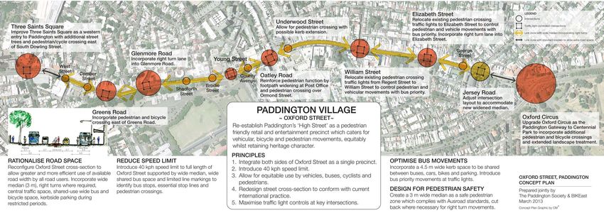
OXFORD STREET, PADDINGTON

Proposal to Redesign a Thoroughfare Consistent with

              Paddington as a Village

                    Prepared jointly by:

                 The Paddington Society
                         BIKEast

                     In collaboration
                       March 2013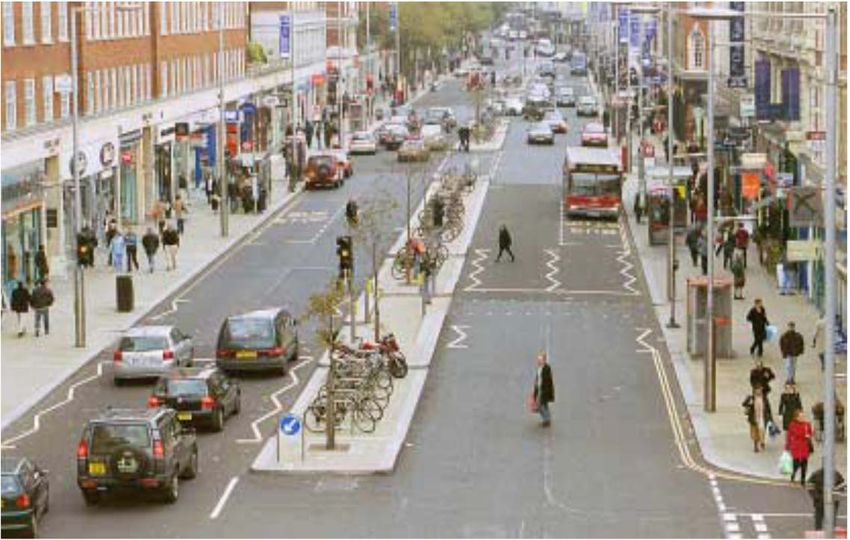
CONTENTS

                 EXECUTIVE SUMMARY 1
                       1.0 Background 3
                        2.0 Objectives 3
                     3.0 Current Problems 5
                      4.0 Opportunities 5
                      5.0 Design Concept 5
                     6.0 Specific Proposals 7

                         APPENDICES

APPENDIX A Report - Road Safety in Kensington High Street
   APPENDIX B Oxford Street Usage - Transport Analysis
            APPENDIX C Proposed Street Profile
                     ACKNOWLEDGMENTS

                Authors of the Proposal include:

                    Adrian Boss BIKEast
      Will Mrongovius President, The Paddington Society
           Geoff Ludowyke The Paddington Society
            Robyn Attuell The Paddington Society
            Bill Morrison The Paddington Society

                       With assistance from:

                     Streetwise Design
           Conybeare Morrison International Pty Ltd

Cover illustration       Graham Stewart, The Paddington Society
OXFORD STREET, PADDINGTON
EXECUTIVE SUMMARY
This proposal addresses the need to reinvent Oxford Street in a contemporary way to
meet its multiple functions as a traffic corridor and important heritage Village
Centre. The needs of vehicular, traffic, public transport, parking, pedestrians and
cyclists as well as the interests of business and residents along the route require a
paradigm shift and cannot be resolved with conventional traffic planning alone.
The problem is not a new one. It has been addressed worldwide for more than 20
years as the perceived need to move traffic has increasingly had a negative impact on
urban environments ultimately resulting in severe urban decay. Solutions have been
developed and implemented in England, Europe and the United States whereby a
philosophy of shared use of space has resulted in a more responsible driving
practice, and a more liveable, shared urban environment, without reducing traffic
flow or safety.
This proposal is based on this philosophy. It calls for the rationalisation of the street
cross-section to introduce a more responsible approach to road usage, minimising
the demarcation between vehicle, traffic and pedestrians, reducing dominance and
speed of motor vehicles and improving road safety and the vitality of Paddington as
a place of heritage significance.
Key features of the proposal outlined in this document include:
40km/h speed limit
A wide pedestrian median
Two travel corridors equivalent to a 3 metre wide movement zone and a 4.5 metre
wide shared bus, car, bicycle and parking zone
Relocating traffic lights to intersections to maximise control of vehicles and
pedestrians at these points
Right turn zones incorporated into the wide central median
Widened footpaths where appropriate
The proposal has been prepared by a professional team with over 30 years
experience in urban design, traffic management and placemaking and is endorsed by
the Executive Committees of BIKEast and The Paddington Society.
Page 1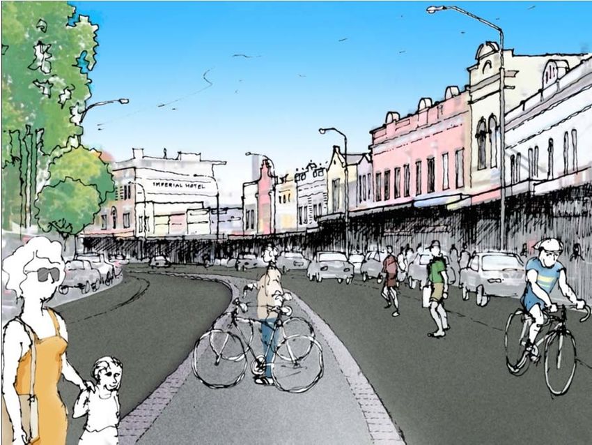
OXFORD STREET, PADDINGTON

                                   VISION

To re-establish Paddington's high street as a pedestrian friendly, retail and
entertainment precinct which caters for vehicular, bicycle and pedestrian
movements without detracting from the Village nature of the Street.

                                                                        Page 2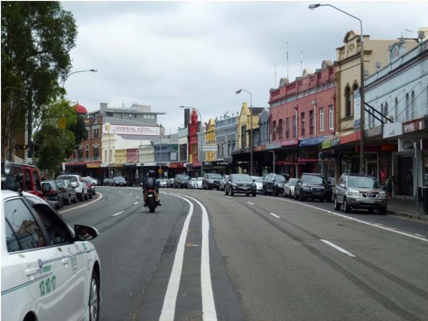
OXFORD STREET, PADDINGTON

1.0   Background
Oxford Street is the major retail and entertainment precinct of Paddington Village. It
incorporates educational, historic and commercial facilities.

Oxford Street has undergone recent tarmac development resulting from
infrastructure work performed by Ausgrid. The RMS and the NSW Government are
further investigating other ways to improve safety and traffic flow on Oxford Street.
Alternative options will be presented to the community later in 2013.

Over the last few years, and unrelated to the tarmac development work, Oxford
Street has declined in popularity as a retail High Street. There are several reasons for
this decline however one factor is that the two sides of the street are not as well
integrated as they could be.

Bicycle traffic has increased within the Sydney region generally and the number of
cyclists using Oxford Street, especially during peak times has increased significantly
in recent years. This upward trend is expected to continue.

It is our view that traffic arrangements in the current format of Oxford Street, simply
do not work and that a rethink of road space usage is required.

BIKEast and The Paddington Society, with local business groups and community
involvement, have considered options to restore the Village atmosphere and submit
these proposals for consideration in any redesign of the thoroughfare.

2.0   Objectives
We wish for proper planning and changes that recognise that Oxford Street is more
than a road.

The road is merely the centre segment of an integrated High Street which meets
multiple purposes for the local community and the many visitors to our Village. We
seek a redesign of the street that recognises and enhances the vitality, viability and
attractiveness of Oxford Street, as a High Street.

The following Objectives have been accepted by all parties making this Submission:

                                                                                  Page 3
2.1 Integration of both sides of Oxford Street as a single precinct.
2.2 Vehicular speed should be sympathetic with a High Street precinct.
2.3 Pedestrians should be able to cross the street safely and simply at all times.
2.4 The needs of pedestrians both able bodied and handicapped, cyclists and both
car and bus drivers must be considered.
2.5 Access and egress to retail facilities is essential.
Page 43.0 Current Problems
The area covered by this submission is Oxford Street between Three Saints Square
(South Dowling Street) and the Paddington Gates, Centennial Park intersection with
Queen Street and Moore Park Road.
Problems with the current/past design include:
Variable speed limits due to School Zones.
Width of central median is insufficient to act as a pedestrian refuge.
Buses often need to travel outside the bus lane.
Width of bus lane does not allow cyclists and buses to pass each other safely.
4.0 Opportunities
There exists an opportunity to reconsider the design of Oxford Street, to provide an
equitable approach to road usage in line with international trends in traffic
management.
As an example, Kensington High Street, London, redeveloped in the mid-2000s, is
suggested as a redesign model where a hectic thoroughfare has been restored to a
successfully functioning High Street. We understand this precinct has regained its
shopping and tourism prominence while maintaining traffic flow and experiencing
improved pedestrian and vehicular safety. (see Appendix A).
Kensington used the 'naked street' approach where conventional lane markings are
replaced by warning marks alerting drivers to sections of shared roadway and where
safe stopping zones are provided for buses, taxis etc.
5.0 Design Concept
The design concept calls for the rationalisation of the street cross-section to eliminate
current problems and introduce a new approach which could be applied across
urban villages throughout Sydney and beyond.
Key features of the concept are:
Retain heritage character of Oxford Street as a broad sweeping urban streetscape.
Introduce traffic management measures which facilitate vehicular, bus, bicycle
and pedestrian movements in an integrated urban environment.
Establish a wide, paved central median which serves as a safe pedestrian zone,
includes secure bike parking and has the capacity for street lighting.
Reduce traffic speed to 40km/h at all times. It is our view that this reduction will
not increase travel time during the peak hours, nor for the majority of trips with
the obvious increase in pedestrian and cycling safety.
Page 5 Limit moving traffic to two unmarked lanes with a kerbside bus zone of 4.5
metres. This width will allow safe movement by buses and cyclists at all times.
Retain kerbside parking with restricted hours.
Integrate the pedestrian and cyclist routes at Queen St/Moore Park Road with the
proposed Centennial Park cycleway.
Page 66.0 Specific Proposals
6.1 Adopt a new approach to the design of Oxford Street by providing roadway
capacity equivalent to two traffic lanes during peak times without the use of
lane markings. Overall roadway width will allow buses to pass cyclists while
remaining in the left part of the carriageway and for cyclists to pass stationary
buses. During non-peak times the roadway will provide for kerbside parking
with sufficient roadway for buses, cars and cycles to flow freely.
6.2 Reduce traffic speeds: consider 30 km/h for upper Paddington, but definitely
introduce 40 km/h speed limit – 24/7, timed to coincide with the introduction
of 40km/h zones in the CBD.
6.3 Create a wide central median where possible. The median should:
provide a safe pedestrian refuge,
have the capacity for bicycle access and parking,
be designed to allow crossings for emergency vehicles,
incorporate required street lighting (removal of light poles from shopfront
pedestrian walkways)
Note No median will be possible where the area is required for dedicated
turning lanes at Jersey Road, Elizabeth Street and William Street.
6.4 Car parking: Peak-hour parking restrictions and existing kerbside parking to be
retained.
6.5 Relocate traffic light controlled pedestrian crossings:
Intersections of Elizabeth Street and William Street should incorporate
traffic lights, creating duplicates of the Jersey Road intersection. This will
facilitate adequate pedestrian flow and allow for efficient use of right turn
lanes from Oxford Street, westbound. Existing controlled crossings
adjacent to these intersections to be removed.
Buses to enjoy a priority departure period at these intersections (as installed
at the Darlinghurst Road intersection), which to be effective may require
considering the relocation of some bus stops.
6.6 Widen pedestrian footways where possible when Oxford Street is redesigned
at a consistent width.
Page 7Current Profile
View towards the city from near Regent Street showing current arrangements
Proposed Profile
View showing reallocation of road space to incorporate wide median and revised travel corridors
Page 8APPENDICES
The following material is provided to support these Specific Proposals:
Appendix A Extract: Report on Road Safety in Kensington High Street
Appendix B Transport Analysis of Oxford Street usage
Appendix C Sketch plans of proposed central median.
Page 10APPENDIX A
Report on Road Safety in Kensington High Street
Extract from Report on Road Safety in Kensington High Street, Royal Borough of
Kensington & Chelsea, London W8 2005
8.1 The main objectives of the scheme were to maintain and enhance the vitality,
viability and attractiveness of Kensington High Street and to re-establish it as
one of the premier shopping destinations in London through the use of
exceptionally high quality materials, attention to detail and a co-ordinated
range of street furniture.
8.2 Overall the casualty reductions over the scheme’s length have matched or
exceeded the equivalent figures for the whole of the Royal Borough and the
general figures for all London.
8.3 The data will be updated for the full three years post-completion and more
detailed work is planned on the data for individual road user groups, other
influential changes and user behaviour.
8.4 The initial encouraging results indicate that innovative change, coupled with
careful detailed design, risk assessment and construction, can be achieved
outside current guidance and without an adverse impact on road safety.
Page 11Results
We have carried out before and after surveys to monitor the scheme. These included
questionnaire surveys of shoppers and attitudinal surveys to find out users
perceptions of the street. Quantitative surveys were also undertaken of pedestrians,
traffic, journey times and speed, bus reliability, traffic queues, parking behaviour,
cycle and pedestrian flows, and cycle parking usage.
Some of the key findings were:
there has been a significant improvement in the public’s perceptions of the
attractiveness, lighting and cleanliness of the High Street
perceptions of safety have not changed much (being very high in both the before
and after situations), but there has been a significant improvement amongst those
in the 65+ age group
there has been a significant improvement in the perceived ease of crossing the
High Street
in general, traffic in the High Street has fallen, and the level of parking activity
has decreased
vehicle journey times have generally improved, as have bus journey times
cycle flows have increased by between 13% (westbound pm) and 30% (eastbound
am)
pedestrian numbers have generally increased by around 7%
the new pedestrian crossings have been especially successful and have attracted
significant use
footway ‘level of service’ has been maintained, with increases in pedestrian flows
being catered for by footway widening
Source: http://www.rbkc.gov.uk/environmentandtransport/transportandstreets/on-streetprojects/kensingtonhighstreet/results.aspx
Note The speed limit in Kensington, including along its 'high street' is 20 mph
(equivalent to 32.2km/h)
Page 12APPENDIX B
Oxford Street Usage - Transport Analysis
The following is a summary of transport along Oxford Street through Paddington,
between Centennial Park and Taylor Square, Darlinghurst.
Key points are:
1. It is a classified Main Road with the roadway effectively controlled by the RMS.
The City of Sydney and the Municipality of Woollahra share other
responsibilities along the street.
2. Motor traffic (other than buses) to and from the Bondi Junction area use the
road mainly for local access and for access to and from Darlinghurst, to
Liverpool and College Street CBD corridors and to and from the southern half
of the CBD. Access to the mid and northern parts of the CBD may use Oxford
Street.
3. Sydney bus services between Bondi Junction and the CBD use this road.
4. Bus lanes with peak-time priority (kerbside parking prohibited) exist. These
lanes are too narrow for buses to overtake cyclists, or for cyclists to overtake
stationary buses whilst remaining within the lane. Buses need to move into the
adjacent (middle) lane to travel between stops.
5. Buses only gain an advance start at the Darlinghurst Road traffic light heading
east. That facility should be installed at other light controlled intersections.
6. Experienced commuter cyclists use the bus lane. This is the major cycling route
between Paddington, the Waverley plateau and the mid and northern parts of
the CBD. Cycle usage has increased significantly in recent times.
7. In non-peak periods, some sections of the bus lanes are allocated for kerbside
parking. With parked cars, there is insufficient room for cyclists to continually
travel within the bus lane. This will force less experienced riders to use other,
less direct routes to their CBD destination.
8. For a large section of Oxford Street three lanes, including the bus lane, are
available during peak times, except at the Jersey Road intersection where one
lane is devoted to right-turn traffic.
9. The main traffic flow capacity constraints are at key intersections:
AM peak – significant and regular congestion occurs at Greens Road, South
Dowling Street and Taylor Square. Irregular congestion occurs at the
Paddington Gates, Centennial Park/Queen Street intersection.
PM peak rarely poses major constraints through Paddington (the main
congestion being in Moore Park Road at the Paddington Gates, Centennial
Park/Queen Street intersection.
Page 1310. For significant periods of time, during the recent trenching works along Oxford
Street only two lanes have been available at peak-times. This has not produced
any significant travel delays.
11. The general speed limit is 50 km/h, with a 40 km/h School Zone limit applied
between Jersey Road and Regent Street especially during the morning peak
time. This limitation also does not contribute to AM delays. This supports the
proposed reduction to 40 km/h for the 1.5 kilometre stretch under discussion.
12. The 50km/h speed limit is not very safe or comfortable for pedestrians or
cyclists crossing or travelling along Oxford Street.
13. Introduction of 40 km/h speed limit is under consideration for the CBD. These
considerations should be extended to include Oxford Street through
Paddington.
14. There is high pedestrian activity along and across Oxford Street. A speed limit
of 30 km/h should be considered for parts of Oxford Street subject to high
pedestrian activity. But generally, a speed limit of 40 km/h is satisfactory for
pedestrian safety.
15. The current median (where it still exists) is very narrow and is not designed for
use as a pedestrian refuge.
16. It does not comply with Austroads guidelines.
17. Additional pedestrian and cyclist crossings are justified at existing traffic lit
intersections at South Dowling Street and Paddington Gates, Centennial Park.
Notes Pedestrian and rider safety has been raised as a major issue at the
Paddington Gates intersection. Growth in motor traffic volumes using
Moore Park Road, the location of the bus and bicycle lanes and the
significant increase in commuter pedestrian and recreational cycle usage,
contributes to safety concerns. Once the proposed off-road bi-directional
cycleway along Oxford Street, between the Woollahra and Paddington
Gates is developed, an additional substantial flow of riders will wish to
use the intersection in all directions, including continuing along Oxford
Street connecting through the Paddington Gates.
18. Average daily vehicle traffic along Oxford at Young Street, is about 31,500
AADT (2005), and is thought to be slowly decreasing. Many main roads with
similar or even higher traffic flows only have two lanes for traffic. For
example, Ocean Street has an AADT (2005) of 32,280, and yet copes with just
one lane north of Jersey Road.
19. A major problem exists west of Victoria Street, where the traffic count along
Oxford Street reaches 68,957 and explains the congestion at the South Dowling
Street intersection.
Page 1420. There may be a solution using Flinders Street however this lies outside the
scope of this proposal.
Page 15APPENDIX C
Proposed Street Profile
Page 16ACKNOWLEDGMENTS
Advice and assistance in the preparation of this report has been provided by:
BIKEast Executive members, particularly:
Dick Van Den Dool, Warren Salomon, Mark Worthington and Adrian Boss
The Paddington Society's Transport Group:
Will Mrongovius, Bill Morrison, Robyn Attuell and Geoff Ludowyke
Charles Nilsen, Manager Urban Design + Architecture, City of Monash
Page 17You can also read