Implementation Assessment of Unpaved Road Condition with High-Resolution Aerial Remote Sensing
←
→
Page content transcription
If your browser does not render page correctly, please read the page content below
Implementation Assessment of Unpaved Road Condition
       with High-Resolution Aerial Remote Sensing

              Colin N. Brooks, Michigan Tech Research Institute (MTRI)
    Dr. Tim Colling, P.E., Michigan Tech Center for Technology and Training (CTT)
                               Christopher Roussi, MTRI
Caesar Singh, P.E., US Department of Transportation Research & Innovative Technology
                                 Administration (RITA)
                                  David Dean (MTRI)
                                Richard Dobson (MTRI)
                           Dr. Melanie Kueber Watkins (CTT)
                             www.mtri.org/unpaved
                              RITARS-11-H-MTU1

                                www.mtri.org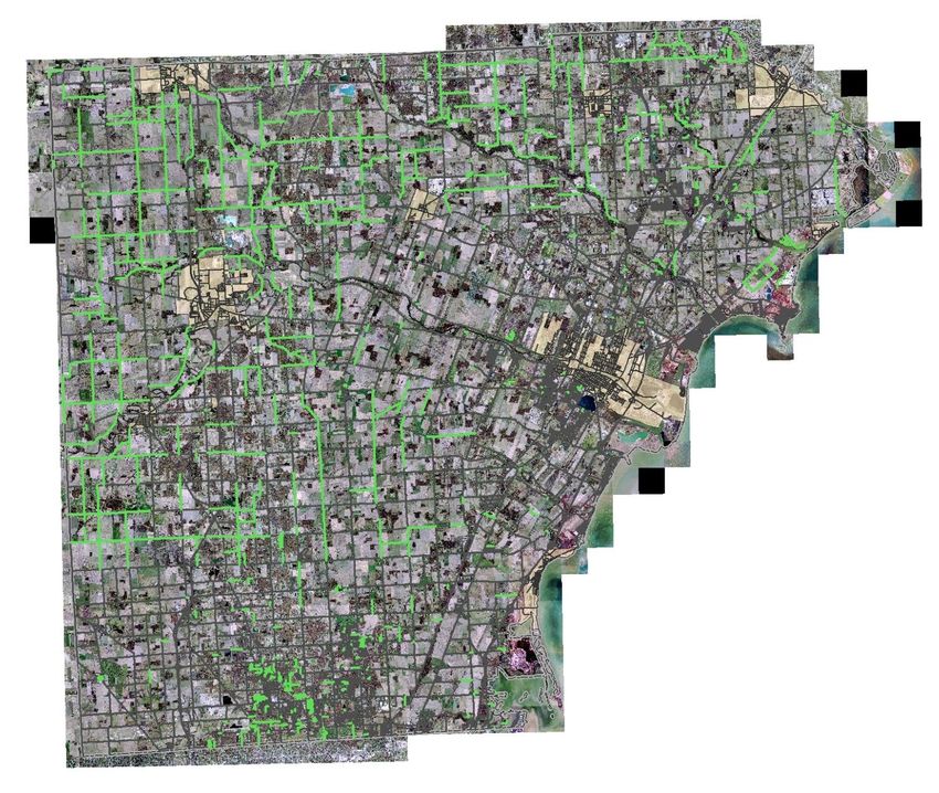
Characterization of Unpaved Road Conditions
                     through the Use of Remote Sensing

Goal of the Project: Extend available Commercial Remote Sensing & Spatial
Information (CRS&SI) tools to enhance & develop an unpaved road assessment
system by developing a sensor for, & demonstrating the utility of remote sensing
platform(s) for unpaved road assessment.
    – Commercially viable in that it can measure inventory and distress data at a rate and cost
      competitive with traditional methods
    – Rapid ID & characterization of unpaved roads
    – Inventory level with meaningful metrics
    – Develop a sensor for, & demonstrate the utility of remote sensing platform(s) for
      unpaved road assessment
    – Platform could be a typical manned fixed-wing aircraft, UAV, or both; depends on
      relative strengths & weaknesses in meeting user community requirements
    – Simplify mission planning, control of sensor system, & data processing fitting for a
      commercial entity or large transportation agency
    – Demonstrate prototype system(s) to stakeholders for potential implementation
      developed through best engineering practices
    – Develop a decision support system to aid the user in asset management and planning

                                                                                              2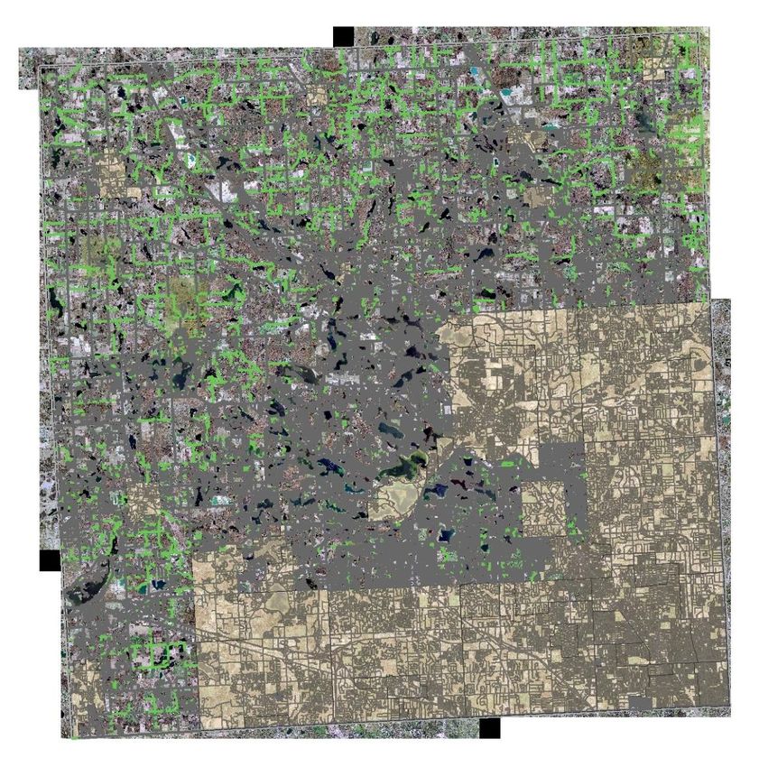
Road Characteristics
•   Unpaved roads have common characteristics
    –     Surface type
    –     Surface width
           •       Collected every 10', with a precision of +/- 4”
    –     Cross Section (Loss of Crown)
           •       Facilitates drainage, typically 2% - 4% (up to 6%) vertical change, sloping
                   away from the centerline to the edge
           •       Measure the profile every 10' along the road direction, able to detect a
                   1% change across a 9'-wide lane
    –     Potholes
               •   6”
               •   Detect the presence of water, elevation +/-2”, width +/-4”                    3

        – Float aggregate (berms)
Combined Methods: Dept. Army
          Unsurfaced Road Condition Index (URCI)

Representative Sample Segments (approx. 100’ long; 2 per ~mile for
representative sample – pg. 2-3 in TM 5-626)
2 Part Rating System
 – Density
     • Percentage of the sample area
 – Severity
     • Low
     • Medium
     • High
Good candidate method to focus on because
it offered a clear set of measurement
requirements, the realistic possibility of
collecting most of the condition indicator
parameters, and the potential applicability to
a wide variety of U.S. unpaved roads.
Endorsed by TAC as effective rating system
                                                                     4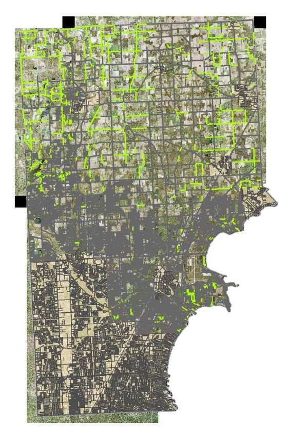
Combined Methods: Dept. Army
               Unsurfaced Road Condition Index

Decision matrix from distress criteria (Eaton 1987a)

                                                       5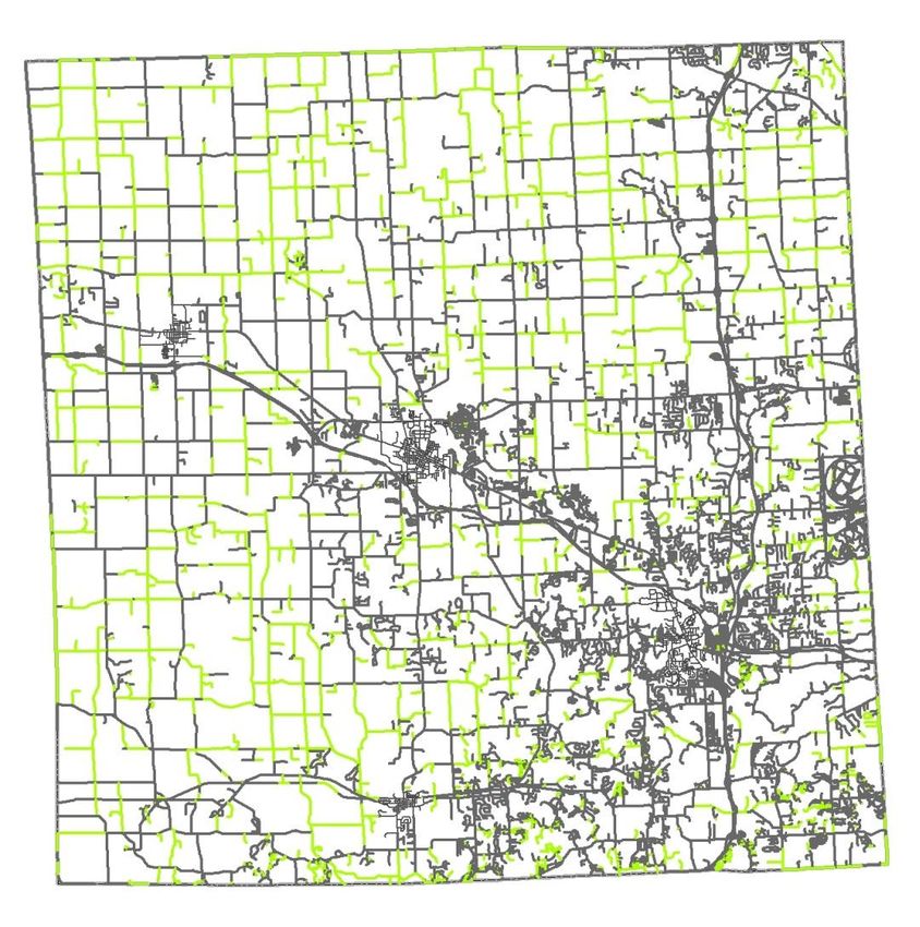
Summary of requirements
Number   Name                   Type       Definition
1        Data Collection Rate   Sensor     The systems must collect data at a rate that is competitive
                                           with current practice (to be determined, TBD)
2        Data Output Rate       System     Processed outputs from the system will be available no
                                           later than 5 days after collection
3        Sensor Operation       Sensor     “easy”, little training required
4        Platform Operation     Platform   Training needed TBD, based on platform choice
5        Reporting Segment      System     6”, precision +/-4”, hole depth >4”,
                                           precision +/-2”. Report in 4 classes: 3’
11       Ruts                   Distress   Detect >5” wide x 10’ long, precision +/-2”
12       Corrugations           Distress   Detect spacing perpendicular to direction of travel >8” -
                                           1”. Report 3 classes: 3”.
                                           Report total surface area of the reporting segment
                                           exhibiting these features
13       Roadside Drainage      Distress   Detect depth >6” from pavement bottom, precision +/-2”,
                                           every 10ft. Sense presence of standing water, elevation
                                           precision +/-2”, width precision +/-4”
14       Loose Aggregate        Distress   Detect berms in less-traveled part of lane, elevation
                                           precision +/-2”, width +/-4”
15       Dust                   Distress   Optional – measure opacity and settling time of plume
                                           generated by pilot vehicle
                                                                                                          6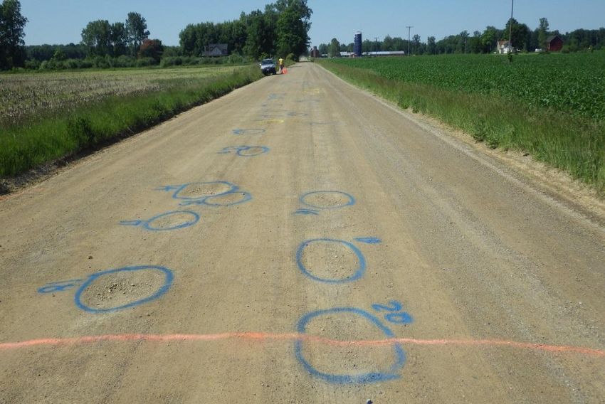
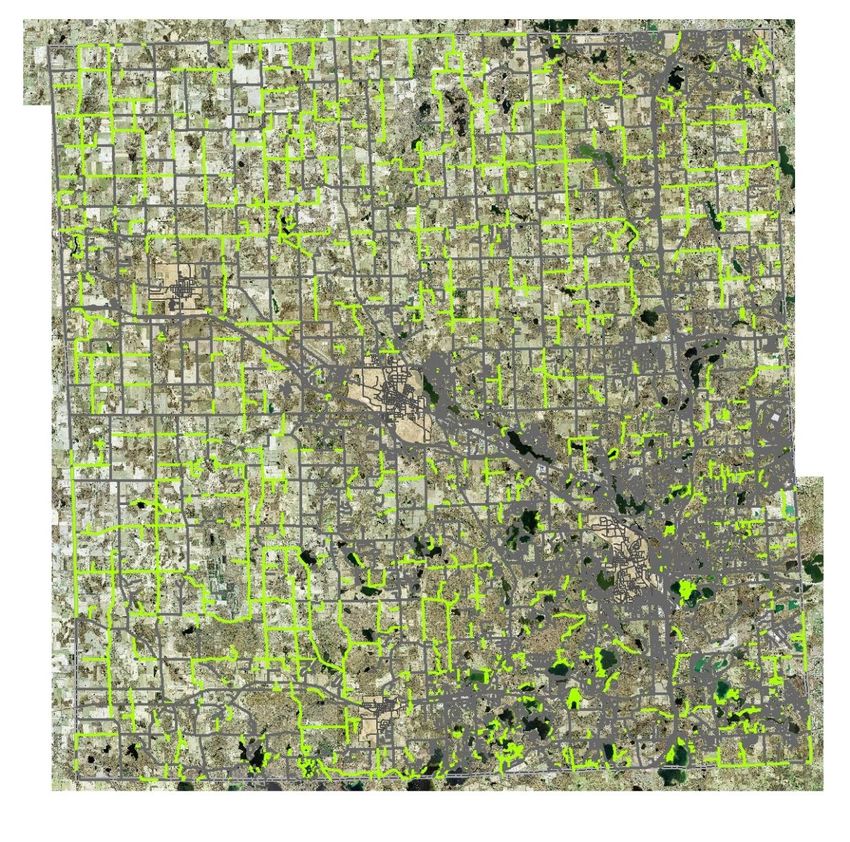
Inventory: Surface Type
How many miles of unpaved road are there? Not all counties have this.
Need to able to determine this inventory
c. 43,000 (1984 estimate) – but no up-to-date, accurate state inventory exists
c. 800 miles in Oakland County estimate
We are extracting this from recent, high-resolution aerial imagery, focusing on
unincorporated areas – attribute existing state Framework roads layer
Completed Oakland, Monroe, Livingston, St. Clair, Macomb, Washtenaw,
Counties; shared with SEMCOG, adding to RoadSoft GIS asset management
tool
87%-94% accuracy
Ex: Livingston Co.: 894 miles unpaved
1289 miles unpaved
7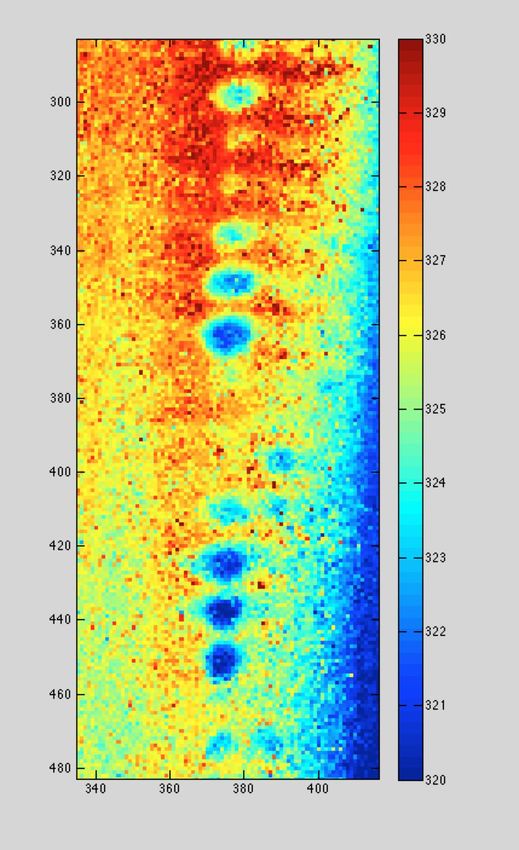
Unpaved Road Detection Results

                       Monroe County
                     Accuracy Assessment
                       at 30% coverage
                           Users           Producers Overall

                 Unpaved           93.9%       77.5%      94.3%

                 Paved             94.3%       98.7%

                                              Mileage
                           Paved               1390.0
                           Unpaved              351.9
                           Total
                           Mileage             1741.9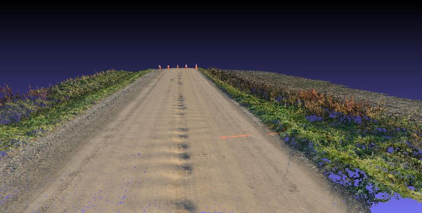
Integration of unpaved road inventory
      results with RoadSoft GIS

                                        9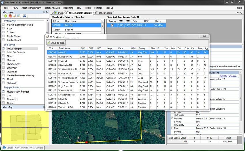
Unpaved Road Detection Results

                     Oakland County
                   Accuracy Assessment
                     at 25% coverage

                          Users           Producers Overall

                Unpaved           83.6%       62.2%      89.4%

                Paved             90.5%       96.7%

                                             Mileage
                          Paved               2948.2
                          Unpaved              693.9
                          Total
                          Mileage             3642.1
Unpaved Road Detection Results
Macomb County
Accuracy Assessment
20% coverage
Users Producers Overall
Unpaved 71.8% 60.9% 94.3%
Paved 96.2% 97.6%
Mileage
Paved 1847.0
Unpaved 319.4
Total
Mileage 2166.4Unpaved Road Detection Results
Livingston County
Accuracy Assessment
25% coverage
Users Producers Overall
Unpaved 83.8% 72.1% 87.2%
Paved 88.4% 93.8%
Mileage
Paved 1289.4
Unpaved 894.1
Total
Mileage 2183.5Selected sensor: Nikon D800
Body type
Body type Mid-size SLR
Nikon D800 – full-sized (FX) sensor, 36.3 Mp, Body material
Sensor
Magnesium alloy
4 fps - $3,000 Max resolution
(px)
7360 x 4912
Effective pixels 36.3 megapixels
More than meets all our requirements Sensor photo
detectors
36.8 megapixels
Other resolutions 6144 x 4912, 6144 x 4080, 5520 x 3680, 4800 x 3200, 4608 x 3680, 4608 x
Weight prime lens, weights ~1.5 kg Image ratio w:h
3056, 3680 x 2456, 3600 x 2400, 3072 x 2456, 3072 x 2040, 2400 x 1600
5:4, 3:2
Sensor size Full frame (35.9 x 24 mm)
Sensor type CMOS
Processor Expeed 3
Color space sRGB, Adobe RGB
Color filter array Primary Color Filter
Image
ISO 100 - 6400 in 1, 1/2 or 1/3 EV steps (50 - 25600 with boost)
White balance 12
presets
Custom white Yes (5)
balance
Image No
stabilization
Uncompressed .NEF (RAW)
format
JPEG quality levels Fine, Normal, Basic
File format • NEF (RAW): 12 or 14 bit, lossless compressed, compressed or
uncompressed
• TIFF (RGB)
• JPEG
Optics & Focus
Autofocus • Phase Detect
• Multi-area
• Selective single-point
• Tracking
• Single
• Continuous
• Face Detection
• Live View
13Platforms
Bergen Helicopter
– Total flight time: 16 minutes (not including 2
minute reserve); flight time for a 200 meter
section ~ 4 minutes.
– Flown at 2 m/s at 25 and 30 meters
– 50mm prime lens
Cessna 172 and 152 Aircraft
– Average air speed: 65 knots (~ 75 mph)
– Flown at altitudes of 500 and 1000 feet
– 105 mm prime lens (2012), 70-200mm zoom
(2013)
Bergen Hexacopter
– Total flight time: up to 30 minutes with small
payloads
– Weight: 4kg unloaded
– Maximum Payload: 5kg
– Includes autopilot system, stabilized mount
that is independent of platform movement,
and first person viewer system (altitude,
speed, battery life, etc.)
14Initial UAV Collect
Flight time for a 200 m section: 4 minutes
During collects helicopter is flown at 2 m/s
and at an altitude of 25 m (82’) and 30 m
(98’)
Example flight at http://www.youtube.com/watch?v=KBNQzM7xGQo 15Field site collections
Five sites were selected in 2012, four
sites were selected in 2013 in SE
Michigan
– Assistance of Road Commission Authorities
aided in the selection of field sites
– None of the sites contained all distress
features of interest for ground truth
assessment, but all were found
– Road graders often hindered data collection
Two collections opportunities in Iowa
and Nebraska (August 2013)
– Verified maintained roads (with the potential
of being maintained using different materials
and methods) in other states could be
categorized with the same processing suite as
Michigan roads
– Selections based on Google Earth imagery
and proximity to Interstate-80
– Results indicate that there were no issues in
assessing road conditions on these other
unpaved roads.
16Ground Truth
17Helicopter Data – Garno Rd.
25m AltitudePerformance – Collected Imagery
Taken from 25m
19Aerial Data – Piotter Rd.
500 ft Altitude3D Reconstruction (Helicopter)
Initial point cloud Densified point cloud
3D surface from point cloud
213D of Piotter Rd (Hexacopter, 27 images)
223D of an Iowa Road (Hexacopter, 18
images)
233D data examples
Important to categorizing distresses by severity
Obtaining 0.9 cm ground sample distance
24Distress Detection – Potholes
Canny Edge detection used to locate edges
Hough Circle Transform is used to locate potholes
Edge Detection Identified circles
Note: Circles near edges ignored. 25Distress Detection – Washboarding
26Distress Detection – Washboarding
Missing
due to
area
threshold
Ground Truth Corrugation Area: Computed Corrugation Area:
19.6 sq. m 17.2 sq. m
27Algorithm Performance Summary In summary, the following data collection parameters will meet all system performance requirements: – 24M-36M-pixel sensor – 50mm, f/1.4 lens set at f/2.8 – 1/250s (maximum) shutter speed (shorter is better) – ISO set as needed for proper exposure given ambient lighting – Distance of 20m-30m from surface – 2m/s (maximum) forward speed – 2fps (minimum) image capture rate (obtained with a simple intervalometer) – 64GB high-speed storage medium Results from this system - User feedback: results appearing useful, implementation needed – The Asset Management Council of Michigan, Southeastern Michigan Council of Governments, Road Commission for Oakland County; sharing results with South Dakota DOT 28
Algorithm Performance Summary

Pothole:

Crown Damage:

Rut Detection:

Corrugation Detection:

                                           29
Aerial Sensor Performance
Algorithm performance, and the ability to meet the stringent requirements on resolution,
depends on the ability to collect data that has enough angular diversity to be able to
reconstruct three dimensions from two dimensions.
– As the distance from the ground increases, the solid angle that any object subtends decreases, and
at some point, becomes too small for high-resolution reconstruction.
– Data taken from an altitude of 500 feet do not meet the system requirements in resolution. That is,
the reconstructed pixels have been found to be “too large”. This is due to the lack of sufficient
angular diversity.
Solutions:
– More data are collected with the camera points at the
same point on the ground, but at oblique (as well as
nadir) views.
– Several passes over the same location can be made,
with the camera at different angles.
– Much higher resolution sensors, with a wider-angle lens
than the 200mm currently used, would allow data to be
taken in a single pass.
Use of a sensor at altitudes above 400 feet is not
practical at this time, only sensors flown at altitudes
below 100m will meet all the performance (i.e.
resolution) and cost-effectiveness requirements.
30Analyzed data are integrated into
RoadSoft GIS Decision Support System
31Road Analysis Process Flow – RoadSoft DSS
integration
3 Surface Identification 2
1
Identify Data From Images
Collect Aerial
Unsurfaced Aerial Imagery
Imagery
Road Network Analysis
Surface Identification
Manual Inspection Functions in
7
Compile
eCognition
Distress Data
Distress and From Platform
Inventory Data 5
For Samples 4
Fly Data
6 Identify Sample
Collection
Data Processing Locations In
Distress Data From Sorties with
Flight System
Manual Inspection Platform
8
Assign Samples Functions in
to Represent Network Field Report
Network Condition Platform System
Report
9 10 12
11
DSS Analysis of Selection of Determine Data
Record
Data Candidates & Needs and Repeat
Competed Work
Scheduling Cycle
Maintenance Completed Functions in
Plan & Budget Project History
RoadSoft 32DSS Ranking System
33Costs – Manual Characterization
Cost assumptions are described in detail in Deliverable
7-B that will be posted to the project website once
approved.
34Costs – Remote Sensing
UAS (UAV, high-resolution camera, and good-quality lens):
• Cost per mile rated $30,590/yr/1575 mi/yr = $19.42/mi rated.
• HOWEVER…two 100-foot measured segments represent one mile of
road, so 5,280 ft/200ft is 26.4. Therefore each mile of measured road
represents a road network 26 times larger.
• Therefore cost is $0.74 per mile, in addition to the cost of vehicle use
($0.55/mi)
– 8 hours/day, 3 days/week, 21 week season to collect 300 road-miles of data segments
Manned Fixed Wing:
• Cost per mile rated $54.47 per mile assessed for up to five sites
per mile
• $10.26 per mile (generous assumption of continuous data
collection)
• $16,340 for same type of analysis as listed above
Caution must be made for cost comparisons between remote sensing and
manual characterization of road conditions due to the resolutions of the
outputs; centimeter-by-centimeter analysis of entire road segments is
essentially impossible via manual inspection.
35Administrative Issues – FAA regulations It should be noted that current (as of October 2013) FAA regulations do not adequately address UAS operations for private entities. – The FAA document 14 CFR Part 91 (http://www.faa.gov/about/initiatives/uas/reg/media/frnotice_uas.pdf ) specifically excludes individuals or companies flying model aircraft for business (commercial) purposes. – For public entities (such as the USDOT), the process of operating a UAS involves obtaining a Certificate of Authorization (COA) for a particular mission. Each mission must have its own COA, which effectively prevents the current use of UASs for arbitrary unpaved road assessment. Thus, under current FAA guidelines, there is no way to deploy an unmanned system for this purpose. – However, some agencies with COAs have been able to get them reapproved within relatively short time periods (< 1 month). – New Dec. 2013 5-year FAA UAV integration RoadMap This may change by late 2015, when the FAA has to have established regulations dealing with Unmanned Aerial Systems (UASs) in the National Airspace System (NAS). New regulations for small UAVs (SUAS) due by Nov. 2014 – “file & fly” for under 55 lbs SUAS? More practical deployment starting in 2015 - commercially 36
Contact Info
                      Colin Brooks cnbrooks@mtu.edu
                  Desk: 734-913-6858, Mobile: 734-604-4196
                    Michigan Tech Research Institute, MTRI
                         3600 Green Court, Suite 100
                            Ann Arbor, MI 48105
                                www.mtri.org
                  Tim Colling, Ph.D., P.E. tkcollin@mtu.edu
                        Chris Roussi croussi@mtu.edu
                       Rick Dobson rjdobson@mtu.edu
                        David Dean dbdean@mtu.edu
            Melanie Keuber Watkins, Ph.D., P.E. mkueber@mtu.edu
                     www.mtri.org/unpaved

DISCLAIMER: The views, opinions, findings and conclusions reflected in this
presentation are the responsibility of the authors only and do not represent the
 official policy or position of the USDOT/RITA, or any State or other entity.
                                                                                   37
You can also read