Pca postclassicalarchaeologies - european journal of - Post-Classical Archaeologies
←
→
Page content transcription
If your browser does not render page correctly, please read the page content below
pca
PCA 7_2017_06-19.qxp_gao 6 30/06/17 10:10 Pagina 1

                                                                           european journal of
                                                         postclassicalarchaeologies

                                                           volume 7/2017

                                         SAP Società Archeologica s.r.l.

                                                     Mantova 2017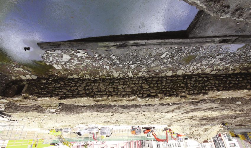
pca
PCA 7_2017_06-19.qxp_gao 6 14/07/17 10:47 Pagina 2

         EDITORS                                                              EDITORIAL BOARD

         Gian Pietro Brogiolo (chief editor)                                  Gilberto Artioli (Università degli Studi di Padova)

         Alexandra Chavarría (executive editor)                               Paul Arthur (Università del Salento)
                                                                              Margarita Díaz-Andreu (ICREA - Universitat de Barcelona)
         ADVISORY BOARD                                                       José M. Martín Civantos (Universidad de Granada)
         Martin Carver (University of York)                                   Girolamo Fiorentino (Università del Salento)
                                                                              Caterina Giostra (Università Cattolica del Sacro Cuore di Milano)
         Matthew H. Johnson (Northwestern University of Chicago)
                                                                              Susanne Hakenbeck (University of Cambridge)
         Giuliano Volpe (Università degli Studi di Foggia)
                                                                              Vasco La Salvia (Università degli Studi G. D’Annunzio di Chieti e Pescara)
         Marco Valenti (Università degli Studi di Siena)                      Bastien Lefebvre (Université Toulouse - Jean Jaurès)
                                                                              Alberto León (Universidad de Córdoba)
         ASSISTANT EDITOR
                                                                              Tamara Lewit (Trinity College - University of Melbourne)
         Francesca Benetti                                                    Federico Marazzi (Università degli Studi Suor Orsola Benincasa di Napoli)
                                                                              Dieter Quast (Römisch-Germanisches Zentralmuseum Mainz)
         LANGUAGE EDITOR                                                      Andrew Reynolds (University College London)

         Rebecca Devlin (University of Louisville)                            Mauro Rottoli (Laboratorio di archeobiologia dei Musei Civici di Como)
                                                                              Colin Rynne (University College Cork)

         Post-Classical Archaeologies (PCA) is an independent, international, peer-reviewed journal devoted to the communication
         of post-classical research. PCA publishes a variety of manuscript types, including original research, discussions and review
         articles. Topics of interest include all subjects that relate to the science and practice of archaeology, particularly multidisci-
         plinary research which use specialist methodologies, such as zooarchaeology, paleobotany, archaeometallurgy, archaeom-
         etry, spatial analysis, as well as other experimental methodologies applied to the archaeology of post-classical Europe.
         Submission of a manuscript implies that the work has not been published before, that it is not under consideration for
         publication elsewhere and that it has been approved by all co-authors. Each author must clear reproduction rights for
         any photos or illustration, credited to a third party that he wishes to use (including content found on the Internet). For
         more information about ethics (including plagiarism), copyright practices and guidelines please visit the web site
         www.postclassical.it.
         PCA is published once a year in May, starting in 2011. Manuscripts should be submitted to editor@postclassical.it
         in accordance to the guidelines for contributors in the webpage http://www.postclassical.it
         Post-Classical Archaeologies’s manuscript review process is rigorous and is intended to identify the strengths and weak-
         nesses in each submitted manuscript, to determine which manuscripts are suitable for publication, and to work with the
         authors to improve their manuscript prior to publication.
         This journal has the option to publish in open access. For information please visit the web site www.postclassical.it
         How to quote: please use “PCA” as abbreviation and “Post-Classical Archaeologies” as full title.
         Cover image: embankments at the Danube waterfront of Regensburg “Donaumarkt“ made of re-used Roman material,
         probably Carolingian (S. Codreanu-Windauer, BLfD 2014).
         “Post-Classical Archaeologies” is indexed in Scopus. It was approved on 2015-05-13 according to ERIH PLUS criteria for
         inclusion. Classified A by ANVUR (Agenzia Nazionale di Valutazione del sistema Universitario e della Ricerca).
         DESIGN
         Paolo Vedovetto
         PUBLISHER
         SAP Società Archeologica s.r.l.
         Strada Fienili 39/a, 46020 Quingentole, Mantova
         www.archeologica.it
         PRINTED BY
         Tecnografica Rossi, Via I maggio, Sandrigo (VI)

         Authorised by Mantua court no. 4/2011 of April 8, 2011
         For subscription and all other information visit the web site www.postclassical.it

          ISSN 2039-7895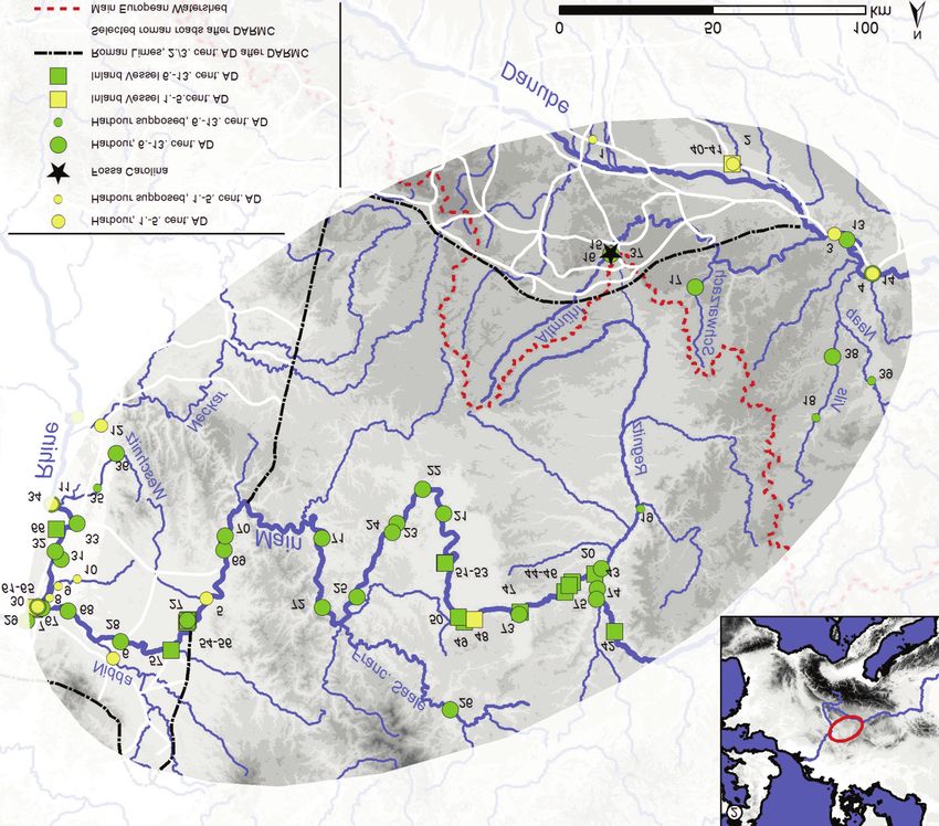
pca
PCA 7_2017_06-19.qxp_gao 6 10/07/17 13:48 Pagina 3

                                                                                european journal of
                                                               postclassicalarchaeologies
                                                                                   volume 7/2017

                                                                         CONTENTS PAGES

                EDITORIAL                                                                  5

                RESEARCH - RIVERS AND WATERWAYS IN THE MIDDLE AGES
                E. Oksanen     Inland waterways and commerce in medieval England           7
                R. Jones, R. Gregory, S. Kilby, B. Pears Living with a trespasser: ri-     33
                              parian names and medieval settlement on the River
                              Trent floodplain
                L. Werther, L. Kröger Medieval inland navigation and the shifting flu-     65
                              vial landscape between Rhine and Danube (Germany)
                A. Dumont, P. Moyat, L. Jaccottey, C. Vélien, M. Cayre, L. Chavou-         97
                              tier, N. Kefi, C. Chateau Smith The boat mills of the
                              Doubs, from the Middle Ages to the 20th century
                P.G. Spanu     Paesaggi di foce: il Tyrsus flumen e i porti medievali di   123
                               Aristanis
                G.P. Brogiolo, J. Sarabia-Bautista Land, rivers and marshes: chang-        149
                               ing landscapes along the Adige River and the Eu-
                               ganean Hills (Padua, Italy)
                A. Arnoldus-Huyzendveld The Lower Tiber valley, environmental              173
                             changes and resources in historical times

                BEYOND THE THEME
                C. Rivals      The modeling of urban spatial dynamics in long time         201
                               spans: the use of graph theory to study a block in
                               Saint-Antonin-Noble-Val (Tarn-et-Garonne, France)
                               from the 14th to the 19th centuries
                P. Arthur, A. Buccolieri, M. Leo Imperiale Experimental rehydroxyla-       225
                              tion and the dating of early medieval and Byzantine ce-
                              ramics. A southern Italian case study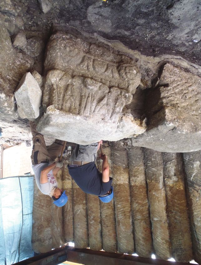
PCA 7_2017_06-19.qxp_gao 6 12/07/17 14:36 Pagina 4

                J. Herrerín López, L. Muñoz Ugarte, N. Sarkic, R. Dinarés Patholo-                      239
                              gy in the Christian medieval necropolis of “La Mag-
                              dalena”, Viana de Duero, Soria, Spain (c. 14th-15th)
                A. Chavarría Arnau, F. Benetti, F. Giannetti, V. Santacesaria Build-                    265
                              ing participatory digital narratives about medieval
                              Padua and its territory

                DOSSIER
                M. Granieri       Anticommons in cultural heritage                                      293
                E. Giannichedda Appunti su periodi, metodologie e persone. Oltre il                     309
                              Concorsone 2017

                RETROSPECT
                J. Terrier        A historical overview of medieval archaeology in                      317
                                  Switzerland

                PROJECT
                D. Edwards, C. Rynne The history and archaeology of the Irish colo-                     329
                             nial landscapes of Richard Boyle, 1st earl of Cork,
                             c.1595-1643

                REVIEWS                                                                                 343
                S. Rippon, C. Smart, B. Pears, The Fields of Britannia. Continuity and Change in
                        the Late Roman and Early Medieval Landscape - by N. Holbrook
                K. Buhagiar, Malta and Water (AD 900 to 1900): Irrigating a Semi-Arid Land-
                       scape - by A. Reynolds
                V. Volpe, Un patrimonio italiano. Beni culturali, paesaggio e cittadini - by V. Nizzo
                C. Giostra (ed), Archeologia dei Longobardi. Dati e metodi per nuovi percorsi di ana-
                        lisi - by A. Chavarría Arnau
                A. Molinari, R. Santangeli Valenzani, L. Spera (eds), L’archeologia della produzione
                        a Roma (secoli V-XV) - by F. Marazzi
                I. Cartron, D. Castex, P. Georges, M. Vivas, M. Charageat (eds), De Corps en
                        Corps. Traitement et devenir du cadavre - by G. Sinigaglia
                C.-N. Douady, La ville comme processus. Derriere la forme urbaine, quelle dyna-
                       miques? Un essai - by F. Giacomello
                R. Skeates (ed), Museums and Archaeology - by F. Benetti

                                                                   PCA volume 7/2017 ISSN: 2039-7895
                                                                   Post-Classical Archaeologies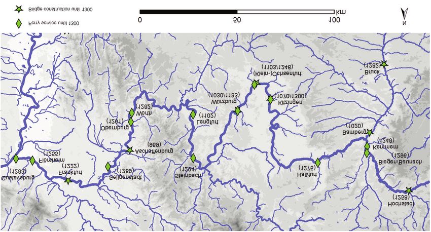
PCA 7_2017_06-19.qxp_gao 6 30/06/17 10:11 Pagina 65

                PCA 7 (2017) ISSN: 2039-7895 (pp. 65-96)
                Post - Classical Archaeologies                                                                        research

                          Medieval inland navigation
                    and the shifting fluvial landscape
                between Rhine and Danube (Germany)

                                                               * Friedrich-Schiller-Universität Jena, Löbdergraben

                LUKAS WERTHER*
                                                               24a, D-07743 Jena, Germany. Corresponding author:
                                                               lukas.werther@uni-jena.de

                LARS KRÖGER**
                                                               ** Deutsches Schiffahrtsmuseum, Leibniz-Institut für
                                                               deutsche Schifffahrtsgeschichte, Hans-Scharoun-Platz
                                                               1, D-27568 Bremerhaven, Germany.

                Post-classical inland navigation and fluvial infrastructure between Rhine and Danube has
                been a pivotal point of research in the last decade. The aim of the paper is to overview
                the complex interplay and development between groups using and transforming rivers for
                different purposes as well as transported goods, legal frameworks, riverine vessels, har-
                bours and river crossings. Based on archaeological, historical and geographical sources,
                structural changes of navigation from antique pre-conditions to the later Middle Ages will
                be discussed.
                Keywords: southern Germany, inland navigation, fluvial landscapes, infrastructure, Middle
                Ages

                La navigazione interna e le infrastrutture fluviali post-classiche tra Reno e Danubio sono
                state un cruciale argomento di ricerca negli ultimi dieci anni. Questo articolo si propone di
                offrire una panoramica della complessa interazione e dello sviluppo tra gruppi che usavano
                e trasformavano i fiumi per differenti motivi, delle merci trasportate, della cornice giuridi-
                ca, delle imbarcazioni fluviali, delle darsene e degli attraversamenti fluviali. Sulla base delle
                fonti archeologiche, storiche e geografiche, verranno discussi i cambiamenti nella naviga-
                zione dall’antichità fino al Basso Medioevo.
                Parole chiave: Germania meridionale, navigazione interna, paesaggi fluviali, infrastrutture,
                Medioevo

                    1. Introductory remarks

                   Focusing on the 6th to 13th century AD, this study highlights post-
                classical inland navigation and the use of shifting fluvial landscapes in
                Southern Germany. We discuss the topic for the rivers Main and upper
                Danube with their important tributaries and some outlooks on the Upper
                Rhine. This study area (fig. 1) is framed by the antique and medieval cen-

                                         Received: 20-01-2017 - Accepted: 22-02-2017 - Revised: 08-03-2017                65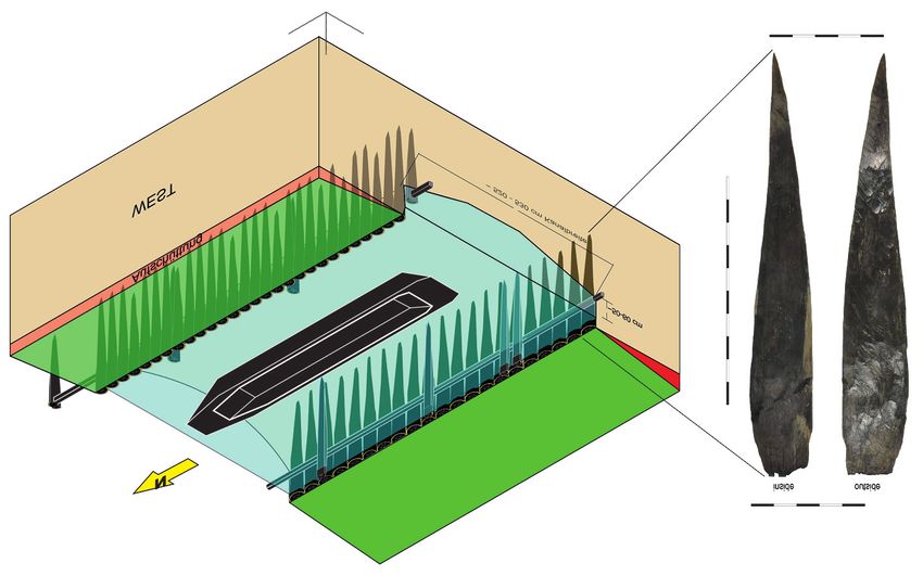
PCA 7_2017_06-19.qxp_gao 6 30/06/17 10:11 Pagina 66

                                                 Lukas Werther, Lars Kröger

                 1                                                                     2

                Fig. 1. 1: General map of harbours and vessels proofed by archaeological and written
                sources at selected rivers between Mainz and Regensburg (1st-13th century AD, status
                2016). All numbers refer to the tables in figs. 2, 3, 5 and 11. The higher density along
                the river Main is caused by the systematic collection of ferry harbours only in this part of
                the study area. 2: Location of the study area in Europe (map data SRTM-GDEM © NASA
                2009, CCM River and Catchment Database © European Commission 2007).

                ters and traffic junctions Mainz and Regensburg. They form the two
                edges of a transport axis which connects the hydrological systems of
                Rhine and Danube by bridging the main European watershed.
                   Nevertheless, rivers are not only connecting but also dividing fea-
                tures, representing borders and obstacles, favorable routes, sources of
                energy and resources as well as permanent danger at the same time for
                those living at the waterfront, navigating or crossing them (Squatriti
                2000; Bütow 2011; Edgeworth 2011; Campbell 2012; Franconi 2016).
                On a large scale, the hydrological system is stable over millennia, but on
                a micro-scale the complex interplay of natural dynamics and anthro-

                66
PCA 7_2017_06-19.qxp_gao 6 30/06/17 10:11 Pagina 67
Medieval inland navigation and the shifting fluvial landscape between Rhine and Danube (Germany)
pogenic influence resulted in shifting fluvial landscapes – and therefore
highly dynamic conditions for inland navigation (Ellmers 2007, pp. 163-
164; Schirmer 2007; Dambeck et al. 2008; Wawrzinek 2009; Hoff-
mann et al. 2010; Edegworth 2011; Roggenkamp, Herget 2014; Fran-
coni 2016; Werther 2016).
There are three main reasons to use rivers for navigation despite of
all problems: the often (but not always, see Bütow 2011, pp. 21-22)
cheaper, faster or more comfortable transport compared to terrestrial
routes, the need to cross rivers and the use of specific aquatic re-
sources by boat.
2. Roman pre-conditions for medieval navigation between Rhine and
Danube, 1st-5th century AD
In the Roman period, the limes divided the study area in regions with
and without Roman infrastructure for inland navigation. For a certain pe-
riod, Main and Danube have been used as borders, too. Between these
borders, most of the fluvial axis bridging the main European watershed
between Rhine and Danube was located in the barbaricum and roads
from the upper Danube to the Rhine-Neckar area connected the sepa-
rated (fig. 1) harbour networks (Kemkes 2005; Steidl et al. 2008, pp.
14-48; Preiser-Kapeller, Werther in press).
From the 1st century AD onwards, the Roman military as well as civil-
ian ship-owner navigate the rivers inside (and sometimes outside) the
limes. Besides the fast transportation of troops, the easy distribution of
bulk goods especially downstream made ships an essential means of
transportation (Marlière 2001; Höckmann 2003a; Fischer 2007, p. 98;
Konen 2008; Steidl et al. 2008, pp. 27-129; Weski 2009; Himmler
2011; Schmidts 2011; Campbell 2012, pp. 291-329; Domínguez-
Delmás et al. 2014; Kulovits 2014; Franconi 2016). With the Roman
expansion, complex planked vessels – fast military boats as well as
heavy-load cargo ships – have been introduced to southern Germany, as
shipwrecks (figs. 2, 4) from Oberstimm and Mainz document (Bockius
2002, 2003, 2006).
In important riverine centres such as Mainz/Mogontiacum (Höckmann
2003b; Wawrzinek 2014, pp. 312-314) and Augsburg/Augusta Vin-
delicum (Wawrzinek 2014, pp. 227-228), complex wooden harbour con-
structions (fig. 3) with quays, piers and perhaps even artificial basins
have been excavated, sometimes connected with shipwrecks (Bockius
2006). A masonry quay wall in Stockstadt at the Main waterfront gives
67PCA 7_2017_06-19.qxp_gao 6 30/06/17 10:11 Pagina 68
Lukas Werther, Lars Kröger
Number Dating (d: den-
Name River Construction Reference
on map drodated)
40 Oberstimm 1 Sandrach keel boat ca. 110d Bockius 2002
41 Oberstimm 2 Sandrach keel boat ca. 110d Bockius 2002
Ebensfeld, EN Katalog Kröger in
42 Main logboat ca. 1235d
61 prep. EN-61
Katalog Kröger in
43 Bamberg, EN 2 Main logboat after 1123d
prep. EN-2
Stettfeld, EN Katalog Kröger in
44 Main logboat after 824d
36 prep. EN-36
Staffelbach, EN Katalog Kröger in
45 Main logboat ca. 1170d
81 prep. EN-81
Katalog Kröger in
46 Viereth, EN 93 Main logboat after 1157d
prep. EN-93
Mariaburghau- Katalog Kröger in
47 Main logboat after 606d
sen, EN 97 prep. EN-97
Schonungen, Katalog Kröger in
48 Main logboat after 80d
EN 32 prep. EN-32
Schweinfurt, Katalog Kröger in
49 Main logboat 1207/1208d
EN 33 prep. EN-33
Schweinfurt, Katalog Kröger in
50 Main logboat ca. 1268d
EN 80 prep. EN-80
Obereisenheim, Katalog Kröger in
51 Main logboat after 1208d
EN 99 prep. EN-99
Obereisenheim, Katalog Kröger in
52 Main logboat after 1247d
EN 100 prep. EN-100
Obereisenheim, Katalog Kröger in
53 Main logboat after 1218d
EN 101 prep. EN-101
Seligenstadt, Katalog Kröger in
54 Main logboat after 1121d
EN 28 prep. EN-28
Seligenstadt, after Katalog Kröger in
55 Main logboat
EN 29 1048d/1242d prep. EN-29
around Seligen- after Katalog Kröger in
56 Main logboat
stadt, EN 31 1085d/1220d prep. EN-31
Steinheim, EN Katalog Kröger in
57 Main logboat after 1284d
109 prep. EN-109
58 Mainz 1 Rhine logboat 377d Bockius 2006
59 Mainz 2 Rhine logboat after 287d Bockius 2006
60 Mainz 3 Rhine logboat 255d Bockius 2006
61 Mainz 4 Rhine logboat 393d Bockius 2006
62 Mainz 5 Rhine logboat 385d Bockius 2006
flat-bottomed
63 Mainz 6 Rhine 81d Pferdehirt 2002
boat
flat-bottomed presumably ca.
64 Mainz 7 Rhine Pferdehirt 2002
boat 75
65 Mainz S8 Rhine logboat after 431d Bockius 2006
flat-bottomed
66 Gimbsheim Rhine ca. 760d Höckmann 1997
boat
Fig. 2. Compilation of vessels (1st-13th century AD) at selected rivers between Mainz and
Regensburg, mapped in fig. 1 (data collection: L. Kröger).
68PCA 7_2017_06-19.qxp_gao 6 30/06/17 10:11 Pagina 69
Medieval inland navigation and the shifting fluvial landscape between Rhine and Danube (Germany)
Written Archaeol.
Number sources sources Dating (d: den-
Name River Reference
on map for the for the drodated)
harbour harbour
Wawrzinek
4th/5th cent. 2014, Katalog B
1 Burghöfe Danube assumed
assumed Höckmann
2003a
Wawrzinek
2014, Katalog A
2 Oberstimm Brautlach yes 1st/2nd cent. d Weski 2010
Höckmann
2003a
Wawrzinek
4th/5th cent. 2014, Katalog A
3 Untersaal Danube assumed
assumed Czysz et al.
2005
from 1st cent.
assumed, Wawrzinek
Regens-
4 Danube assumed assumed continuous use to 2014, Katalog A
burg
the Middle Ages Weski 2010
very likely
Wawrzinek
2014, Katalog A
2nd/3rd
cent.
5 Stockstadt Main yes Weski 2010
assumed
Steidl et al.
2008
Wawrzinek
Nida-Hed- 2nd/3rd cent. 2014, Katalog A
6 Nidda yes
dernheim assumed Steidl et al.
2008
from 1st cent. d,
Wawrzinek
7 Mainz Rhine yes yes continuous use to
2014, Katalog A
the Middle Ages
Schwarz- Wawrzinek 2014,
8 Ginsheim assumed roman
bach Katalog B
4th/5th cent.,
Wawrzinek
Trebur- Schwarz- continuous use to
9 yes 2014, Katalog B
Astheim bach the Middle Ages
Heising 2012
assumed
Groß- roman, from 1st Wawrzinek
10 Altneckar assumed
Gerau cent. assumed 2014, Katalog B
4th/5th cent., Wawrzinek
Wesch-
continuous use to 2014, Katalog A
11 zullestein nitz / yes
the Middle Ages Heising 2012
Rhein
assumed Jorns 1979
Wawrzinek
12 Ladenburg Neckar assumed 4th cent.
2014, Katalog A
Fig. 3. Compilation of roman harbours (1st-5th century AD) at selected rivers between
Mainz and Regensburg (based on Wawrzinek 2014).
69PCA 7_2017_06-19.qxp_gao 6 30/06/17 10:11 Pagina 70
Lukas Werther, Lars Kröger
Fig. 4. Selected vessels of the 1st-13th century AD, dark grey: reconstructed parts. 1:
Mainz 6, dating 81 AD (reduced on the front part). 2: Oberstimm 2, dating around 118
AD. 3: Mariaburghausen, dating after 596d. 4: Stettfeld, dating after 824d. 5: Kalkar-
Niedermörmter, dating around 802d. 6: Krefeld-Gelleg III, dating in the 8th century based
on small finds (drawings L. Kröger after Bockius 2002; Pferdehirt 2002, p. 101; Kröger
2014, pp. 96 and 99; Kröger in press).
proof for more solid stone constructions. Nevertheless, simple landing
sites with stone pavements (Nida-Heddernheim, zullestein, Trebur-Ast-
heim) or wooden bank reinforcements of different complexity (Ober-
stimm, Untersaal) have been the most widespread construction (Jorns
1979; Bockius 2002; Czysz et al. 2005, p. 526; Steidl et al. 2008;
Weski 2010, p. 23; Heising 2012; Kulovits 2014, pp. 51-63;
Wawrzinek 2014, pp. 324-399).
Except of the river Main, which has been outside the limes after mid-
3rd century, the bigger rivers have been used continuously until late An-
tiquity and – on a reduced level – also beyond. Descriptions of grain
ships navigating the Danube in the 5th century according to the Vita
Sancti Severini (Fischer 2007, p. 99; Kulovits 2014, pp. 14-15) as well
as a 5th century shipwreck and early 6th century bank reinforcements at
the Rhine in Mainz give proof for that exemplarily (Bockius 2006;
Wawrzinek 2014, p. 314).
70PCA 7_2017_06-19.qxp_gao 6 30/06/17 10:11 Pagina 71
Medieval inland navigation and the shifting fluvial landscape between Rhine and Danube (Germany)
3. People and purposes using waterways between Rhine and Danube
3.1. People and purposes using waterways, 6th-10th century AD
Specific sources for people using the waterways in the 6th-7th century
are scarce, but the protection of river corridors with fortifications start-
ing in the 7th century (Ettel 2015) and fluvial distribution patterns of
Merovingian ceramics and glass indicate a certain importance of naviga-
tion (Koch 1996; Koch, Koch 1996, pp. 279-280; Ettel 2008). Never-
theless, it is not always clear if the river itself or terrestrial routes par-
allel to the river have been used for transportation (Dopsch 2012, p. 25;
Steidl et al. 2008, pp. 74-112).
From the 8th century onwards more and more written sources spec-
ify passengers navigating the main rivers, but also small tributaries. Es-
pecially in the itineraries of Charlemagne and Louis the Pious there are
many references for navigation upstream and downstream on Rhine,
Main, Danube, Altmühl, Franconian Saale and Regnitz – and also for
crossing the European watershed with ships dragging them overland
(Dopsch 2012; Hack 2014; Regesta Imperii online RI I – Karolinger n.
307a, 320I, 320o, 832b, 899e, 1006b, 1955a; RI IV,2,1 – Lothar III.
und ältere Staufer n. 65; RI IV,2,4 – Lothar III. und ältere Staufer n.
3265)1.
The higher average speed of navigation downstream compared to ter-
restrial transport was a considerable motivation for the highly mobile
elites of the Early Middle Ages (Reinke 1987, pp. 243-251; McKitterick
2008, pp. 181-186). It is debatable if navigation upstream, especially on
small meandering rivers, was also faster than using roads (Bütow
2011), but it was more comfortable, which is also indicated in Carolin-
gian sources (Hack 2014, pp. 54-61). Especially for those who were
less mobile due to diseases or other reasons, the transport by boat was
favorable (Pertz 1826, p. 362; Wagner 2007, p. 38; Hack 2009, pp.
231-253; Regesta Imperii online RI I – Karolinger n. 1955a).
The medieval royal “fluvial” itinerary was often part of military actions,
especially on the Danube. In conflicts at the eastern periphery of the
Carolingian and Ottonian empire, troops used the river for transporta-
tion frequently (e.g. Regesta Imperii online RI I – Karolinger n. 1490e u.
1955a; RI II,1 – Sächsisches Haus n. 238c; Freund 2007, pp. 51-52).
In the 12th century the Danube was used by the crusaders, who depart-
ed from Regensburg to the Holy Land (Dopsch 2012; Regesta Imperii
1 All Regesta mentioned in the article could be found following their number on the RI-homepage cited
in the bibliography.
71PCA 7_2017_06-19.qxp_gao 6 30/06/17 10:11 Pagina 72
Lukas Werther, Lars Kröger
online RI IV, 1, 2 – Lothar III. und ältere Staufer n. 484; RI IV, 2, 4 –
Lothar III. und ältere Staufer n. 3265).
Starting in the 8th century, orders highlight the attempt to improve
the security of pilgrims and other groups navigating the rivers – but as
descriptions of shipwrecks vividly show, this was not always successful
(Regesta Imperii online RI I – Karolinger n. 302; Dopsch 2012, p. 25;
Hack 2015).
In addition to secular elites, ecclesiastic groups were important users
of waterways and ships from the Carolingian period onwards. Not only
the transportation of passengers, but especially the distribution of the
agricultural income of widespread possessions has been crucial in cer-
tain regions and periods (e.g. Regesta Imperii online RI I – Karolinger n.
1431; Regesta Imperii Regg. EB Mainz 1 n. 1; Regesta Imperii Regg. B
Augsburg 1 n. 132; Johanek 1987; Adam 1996, pp. 181-183;
Elmshäuser 2002; Haase et al. 2015).
The 9th century Miracula Sancti Goaris offer a vivid example, how
even ecclesiastic elites have been personally engaged in the transporta-
tion of bulk goods on the river: according to the Miracula, an abbot from
Cologne returned from the vintage on his possessions near Worms, ship-
ping the Rhine downstream on a boat fully loaded with barrels, which
ended in a shipwreck at St. Goar (Hack 2015, p. 194). For this period,
the transport of wine from southern Germany downstream the Rhine is
also proved by archaeological sources, as 8th century wine barrels made
from Bavarian silver fir have been reused in Dorestad (Natris 2009).
Furthermore, there are strong indications that even the construction
wood for early medieval ships excavated in the Netherlands has been cut
in the Rhine-Main area (Brouwers et al. 2015, pp. 13-14). Rhine, Main
and Danube have been intensively used for cargo transport in this period
and professional traders and ship-owner transported e.g. grain, salt and
ceramic vessels (Johanek 1982; Johanek 1987, pp. 19-68; McCormick
2010, pp. 655-656; Hack 2015, pp. 193-202).
Nevertheless, the distribution pattern of Rhenish ceramics and other
products like millstones clearly shows, that huge upstream sections of
Rhine and Main and most tributaries like the Franconian Saale or the
Regnitz have scarcely been integrated in this network (Losert 1993;
Gross 2004; Ettel 2008; Gross 2009; Grunwald 2012; Werther 2012,
p. 240; Werther 2015, pp. 36-37).
South of the European watershed similar structures have been ob-
served, as ceramic wares typical along the Danube such as “Goldglim-
merware” are very rare upstream of Kelheim and along the river Altmühl
(Later 2015, p. 65). Nevertheless, it may not be a coincidence that one
72PCA 7_2017_06-19.qxp_gao 6 30/06/17 10:11 Pagina 73
Medieval inland navigation and the shifting fluvial landscape between Rhine and Danube (Germany)
of the exceptions in the Altmühl region with a bigger amount of “Goldglim-
merware” is the Carolingian harbour of Großhöbing (Liebert 2015, pp.
260-270). Despite of the weak integration of upstream sections and
tributaries in ceramic distribution, regularly navigation on the Altmühl in
the Carolingian period is not only indicated by the royal itinerary (see
above), but also by the 9th century Vita Sualonis describing the suitability
of the river for merchant vessels (Holder-Egger 1887, p. 158; Eckoldt
1980, p. 72; Adam 1996, p. 91). The sources do not mention which
cargo has been transported, but for several northern confluents of the
Danube a relation to the flourishing iron production is very likely (Hensch
2013, pp. 274-294; Later 2013, pp. 318-320; Later 2015, pp. 44-46;
Werther 2015, pp. 213-215).
The examples document clearly, that merchants and elites frequently
used the rivers for navigation, but the everyday use of waterways and
vessels beyond this small group is more difficult to describe. Short and
medium-distance transports of agrarian products by boat have already
been discussed (Haase et al. 2015). People running ferries are seldom
documented before the 12th century in the study area (see below;
Hägermann 1995, p. 169; Adam 1996, p. 158). 10th century docu-
ments regulating the legal framework of royal and private fisherman
working on the river Main at Frankfurt exemplarily enlighten another
group with a strong connection to everyday navigation (Regesta Imperii
Online RI II, 3 – Sächsisches Haus n. 1113), but usually the early
sources concerning fishery give no certain proof for navigation (Häger-
mann 1995; Matthäus 2004; Werther 2012, pp. 254). In rare occa-
sions anthropological data offers another approach to everyday naviga-
tion; in a 8th-10th century graveyard at the confluence of Altmühl and
Danube, several individuals had specific degenerative diseases that have
been interpreted as aftereffects of rowing or punting vessels (Strott
2006, pp. 224-225).
In summary, the sources show clearly that at least on the main rivers
of the study area, but also on some of the smaller tributaries, transporta-
tion of cargo and passengers by boat was very common in the Carolingian
period (Adam 1996, pp. 31-180; McCormick 2010, pp. 655-656; Dop-
sch 2012, p. 25; Hack 2015; Regesta Imperii online RI I – Karolinger n.
2015a). An extraordinary detailed text, the late Carolingian Inquisitio de
theloneis Raffelstettensis, enlightens the complex organization of naviga-
tion for a specific section of the Danube and how it was influenced by the
fluvial conditions: whereas high tolls had to be paid for the easy transport
downstream, navigation upstream against the current was cheaper or
even free of charge (Adam 1996, pp. 123-124).
73PCA 7_2017_06-19.qxp_gao 6 30/06/17 10:11 Pagina 74
Lukas Werther, Lars Kröger
But not only the current significantly affected navigation: watersheds
dividing the hydrological systems have been an even more influential ob-
stacle (Werther et al. 2015; zielhofer et al. 2014). It becomes more and
more apparent, that neither the archaeological material nor the written
sources give proof for a serious transportation of bulk goods between
the systems of Rhine and Danube. The impression of two economic sys-
tems and navigational networks with only weak ties is also supported by
the spectrum of Carolingian coins north and south of the watershed (Em-
merig 2004; Coupland 2014). It seems like kings crossed the watershed
more easily than cargo.
3.2. People and purposes using waterways, 11th-13th century AD
Ecclesiastical institutions participated actively in navigation in the
11th-13th centuries, too, many of them benefiting from water toll exemp-
tions (Hägermann 1995; Regesta Imperii Regg. EB Mainz 1 n. 1008;
Regesta Imperii Regg. EB Mainz 2 n. 378; Regesta Imperii online RI V,
1, 1 – Jüngere Staufer n. 285). A new and more and more dominating
player in the transportation of cargo on the Rhine, Main and Danube are
the flourishing urban centers. In this period, the participation of towns
and citizens in navigation has been facilitated and often directly support-
ed by royal initiatives (e.g. for Worms in 1074 Regesta Imperii Online RI
III, 2, 3 – Salisches Haus n. 680; for Magdeburger in 1025 Regesta Im-
perii Online RI III,1 – Salisches Haus n. 18; Irsigler 1996; Bönnen
2010). Like for the Carolingian Danube, this support included specific
regulations concerning the hydrological conditions: in 1157 Friedrich I.
regulated the water tolls on the river Main, which had to be collected in
Aschaffenburg, Neustadt and Frankfurt for all vessels going down-
stream, whereas all vessels going upstream have been free of charge
(Regesta Imperii Online RI IV, 2, 1 – Lothar III. und ältere Staufer n.
447). Navigation has been highly political and also used for sanctions: to
give an example, in 1121 the Mainz archbishop raised the harbour tolls
in his town for merchants from Duisburg, who supported his opponent
Heinrich V. (Regesta Imperii Regg. EB Mainz 1 n. 1473).
The increasing dependency of many growing towns on the riverine sup-
ply intensified conflicts like that. The building boom of the 12th and 13th
centuries implicated the transportation of huge amounts of construction
material such as wood and stone on the waterways (Steidl et al. 2008,
pp. 228-258; Brouwers et al. 2015, pp. 13-14). This is documented
clearly by many direct traces of rafted wood along the river Main in the
12th century and along the Danube in the early 13th century (Eißing,
Dittmar 2011, pp. 138-143).
74PCA 7_2017_06-19.qxp_gao 6 30/06/17 10:11 Pagina 75
Medieval inland navigation and the shifting fluvial landscape between Rhine and Danube (Germany)
4. Vessels and navigation between Rhine and Danube
For the Roman period several shipwrecks (fig. 2) document the use of
flat-bottomed and keel based vessels (see above). A fragment of a military
rowing vessel from Mainz (S8) dated after 431 documents the late an-
tique use of keel based vessels on the Rhine (fig. 2, no. 65; Bockius
2006, pp. 188-190). At the lower Danube, similar ships for military
operations were still in use around 600 AD (Himmler 2011, pp. 150-
156). Nevertheless, except of some late medieval and post-medieval ves-
sels from the Main near Obereisenheim (Kröger 2013, pp. 118-126),
from the Danube at Kehlheim (Herzig, Weski 2009) and from Mainz
(Höckmann 1999) as well as several badly preserved bits and pieces of
an early medieval boat from Gimbsheim at the river Rhein (fig. 2, no. 66;
Höckmann 1997; Kröger 2014, pp. 95, 111) no planked vessels of the
6th-13th century AD have been documented yet in the study area.
But even if the archaeological material is quite limited, it is very likely
that planked vessels have been used in this period between Rhine and
Danube. It is a general phenomenon, that medieval logboats have been
found almost all over Germany, but planked vessels are only known at the
lower Rhine, around Bremen and in Schleswig-Holstein – natural factors
and formation processes seem to be more important for this distribution
pattern than the actual use of the different construction types in the me-
dieval period (Kröger 2014). The excavated early medieval planked ves-
sels are very similar to antique flat-bottomed cargo vessels, the so-
called “Prahme”, concerning their function, their general hull design and
their construction except of some details – but their sizes are clearly re-
duced (cf. Kröger 2014). This is best documented by the almost com-
pletely preserved vessels from Krefeld-Gellep III with its loading capacity
of almost 7 tons (fig. 4; Pirling, Buchwald 1974; Kröger in press),
Kalkar-Niedermörmter (fig. 4; Kröger in press) at the Rhine and the
“Karl” of Bremen at the Weser (Hoffmann, Ellmers 1990, pp. 33-34;
Mücke 2011, pp. 36-44). The finds from Krefeld and Bremen have pre-
served mast steps, so they could have been not only punted, but also
towed upstream. Especially for smaller vessels and slow currents, punt-
ing is an effective alternative to towing.
Due to their shallow and light construction early medieval boats could
easily land on flat riverbanks without the need of solid installations which
allow to moor afloat. To join the side and bottom planks a L-shaped tran-
sition plank in the floor section was used. This enabled a direct linking of
the side planks with the massive floor planks and the construction got an
enhanced stability, so fewer frames and therefore fewer curved grown
wooden parts were needed. The disadvantage is the need of a whole
75PCA 7_2017_06-19.qxp_gao 6 30/06/17 10:11 Pagina 76
Lukas Werther, Lars Kröger
trunk for every transition plank. This construction technique disappears
at the end of the middle ages and butt joints came into practice (see for
example Höckmann 1999; Schletter 2012).
A special group, planked representative vessels used by the elites,
are documented in contemporary iconographic (Dufrenne, Villain-Gandos-
si 1984) or written sources (see below), but no wrecks have been found
yet. Vessels have also been used as floaters for heavy loads like ship
mills and pontoon bridges, which is documented as early as 792 for the
Danube (Kröger 2014, p. 111; Hardt 2007, pp. 108-109).
In contrast to the very limited number of planked vessels from the
study area, there are several logboats from the 6th-13th centuries AD.
Of special interest is an approximately 14 m long example from Stettfeld
at the river Main. The vessel dated after 824 AD had an enormous load-
ing capacity and was probably used for the transportation of cargo (fig.
2, no. 44, fig. 4; Kröger 2014, p. 102). Furthermore, along the Main sev-
eral logboats with special functions have been documented. A 7th century
find near Hassfurt can be interpreted as a floater for a ferry vessel due
to its specific construction criteria (fig. 4; fig. 2, no. 47). Thirteen similar
logboat floater have been dated to the 12th and 13th centuries, their
characteristic are their small average dimension of 3 m length and 40 cm
width as well as features like horizontal and vertical holes to connect sev-
eral logboats to one raft and to fasten a solid wooden platform (fig. 12;
Kröger in preparation; Kröger 2014, p. 102 and p. 107).
The toll regulation of Friedrich I. in 1157 AD (see above) does not
only document the royal interest in free navigation, but also the impor-
tance of towing paths along the river Main. Those are described explic-
itly as ripa fIuminis quae via regia esse dinoscitur, i.e. river shores,
which are king´s roads. Nevertheless it is not clear, if this means that
construction and maintenance of these towing paths have been royal
duties (Ellmers 2007, pp. 165, 175-176). In 1165, Friedrich I. under-
lines that also the rivers themselves have been king’s routes and at
least nominal they remained so until modern constitutions (Schneider
2007, p. 191). Major interference in the waterway or at the banks
such as the construction of a bridge to cross the river Main in Schwe-
infurt needed royal permission (Müller 2004, p. 18). Nevertheless, in
the later Middle Ages the kings lost their influence on smaller rivers and
upstream sections step by step, as it is documented for Heilbronn
where the town is allowed to block the river Neckar in 1333 (zimmer-
mann 1954, pp. 9-11). If the reduced royal influence on smaller rivers
is a consequence of problems of navigability caused by fluvial processes
such as floodplain sedimentation or changing interests of the riverine
stakeholders is unanswered yet.
76PCA 7_2017_06-19.qxp_gao 6 30/06/17 10:11 Pagina 77
Medieval inland navigation and the shifting fluvial landscape between Rhine and Danube (Germany)
5. Harbours and artificial waterways as nodes for navigation, 6th-13th
century AD
To rest at least for a short time and to move people and cargo be-
tween water and land, ships are in the need of harbours. Every starting
point and destination of a ship could be called a harbour. Usually, cargo
and passengers could come in and get out of a ship at a harbour, vessels
find protection, they can be pulled on the riverbank or be launched the
other way. To fulfill these functions, a harbour may have specific build-
ings, but they are not mandatory (Ellmers 1984, pp. 123-174; Kalmring
2007, pp. 183-204; Wawrzinek 2014; Wunschel et al. 2015, p. 203).
Following this definition, a huge number of harbours of the 6th-13th cen-
turies could be identified in the study area based on written sources and
the archaeological record (fig. 1, 5). Most of these harbours have been
used for navigation upstream and downstream, but there are also ferry
harbours to cross the river from one bank to the other, which will be dis-
cussed in greater detail below. Basically, a ferry harbour or – to be more
precise – a pair of ferry harbours at both banks of a river, could also
serve as a landing for ships going upstream and downstream; often a
clear functional separation is impossible. Therefore, we integrated a cer-
tain number of ferry harbours in the general map of harbours (fig. 1, 5).
What happened with the roman harbours after Antiquity? Often it is
unclear, some have been abandoned, but in urban centers such as Mainz
and also at some minor sites harbours have been continuously used or
reused. In the Rhine area, Trebur-Astheim and zullestein provided evi-
dence for a post-classical harbour function. In 846, a text describes that
zullestein cum portu has been transferred to the nearby monastery of
Lorsch as an important gateway to the river Rhine (Elmshäuser 2002,
pp. 39-40; Molkenthin 2006, p. 140; Heising 2012, pp. 162-163). Dur-
ing the 9th century, written sources enlighten a huge network of naviga-
tion which has been part of the monastic economy of Lorsch. Not only
harbours, but also monastic ships, duties for navigation and exemptions
from water tolls have been integral parts of this system (Elmshäuser
2002, pp. 39-43).
As there are no archaeological sources for most of the harbours and
other places connected to navigation mentioned in the written sources,
their precise localization is often problematic. Furthermore, the very
common term portus is ambiguous (Niermeyer, Kieft 2002, p. 3743). To
make the problem even bigger, many of the locations with mentioned du-
ties for transports cum navi are not identical with the starting points of
these transports and therefore the harbours (Elmshäuser 2002; Haase
et al. 2015, pp. 159-166). Sometimes the harbour destination is more
77PCA 7_2017_06-19.qxp_gao 6 30/06/17 10:11 Pagina 78
Lukas Werther, Lars Kröger
Num- Written archaeol.
ber sources sources Dating (d:
Name River Reference
on for the for the dendrodated)
map harbour harbour
mentioned 9th
13 near Teugn Danube Winckler 2012
cent.
Codreanu-Windauer,
continuous useDallmeier 2015 Dall-
since Antiquity
meier, Kirpal 2011
14 Regensburg Danube yes yes
mentioned Dopsch 2012
since 8th cent.
Hardt 2007
Molkenthin 2006
Werther et al. 2015
15 Graben Altmühl yes mentioned 793 Hack 2014
Molkenthin 2006
Werther et al. 2015
16 Graben Rezat yes mentioned 793 Hack 2014
Molkenthin 2006
Schwar-
17 Großhöbing no yes 768d-855d Liebert 2015
zach
first mentioned
18 Amberg Vils yes Molkenthin 2006
11th cent.
first arch.
19 Forchheim Regnitz yes proof 8./9. Ernst 2014
cent.
first mentioned
20 Bamberg Regnitz yes Molkenthin 2006
11th cent.
first mentioned
21 Kitzingen Main yes Hägermann 1995
11th cent.
first mentioned
23 Heidingsfeld Main yes Hägermann 1995
10th/11th cent.
mentioned
24 Würzburg Main yes assumed Molkenthin 2006
since 8th cent.
first arch. indi-
Wunschel et al. 2015
25 Karlburg Main no yes cations 7th
Ettel 2011
cent.
mentioned Hack 2014
26 Salz Main yes assumed
8th/9th cent. Molkenthin 2006
Seligen- first mentioned Patzold 2013
27 Main yes
stadt 9th cent. Molkenthin 2006
Hack 2014
first mentioned Hampel 2013
28 Frankfurt Main yes yes
793 Molkenthin 2006
Elmshäuser 2002
Biberich first mentioned
29 Rhein yes Molkenthin 2006
near Mainz 9th cent.
http://www.wubon
first mentioned
line.de/ Band VI., Nr.
29 Ochsenfurt Main yes 11th/12th
N9, Seite 436-438
cent.
(27.01.2017)
78PCA 7_2017_06-19.qxp_gao 6 30/06/17 10:11 Pagina 79
Medieval inland navigation and the shifting fluvial landscape between Rhine and Danube (Germany)
Num- Written archaeol.
ber sources sources Dating (d:
Name River Reference
on for the for the dendrodated)
map harbour harbour
Molkenthin 2006
Rhine/ continuous use
30 Mainz yes yes Elmshäuser 2002
Main since Antiquity
Ellmers 1969
Molkenthin 2006
first mentioned
31 Camben Rhine yes Elmshäuser 2002
9th cent.
Büttner 1967
first mentioned Elmshäuser 2002
32 Dienheim Rhine yes
8th cent. Büttner 1967
Elmshäuser 2002
33 Gernsheim Rhine yes 9th/10th cent.
Büttner 1967
probably conti-
nuous use
since Antiquity Siemers 2011
34 zullestein Rhine yes yes first mentioned Elmshäuser 2002
and arch. Büttner 1967
proof 8th/9th
cent.
35 Lorsch Weschnitz yes 721/722d Platz 2009
first mentioned Molkenthin 2006
36 Weinheim Weschnitz yes
9th cent. Elmshäuser 2002
Fossa Ca-
Altmühl/ mentioned Werther et al. 2015
37 rolina yes yes
Rezat 793, 793d Hack 2014
(canal)
Schmidmüh- Vils/ first mentioned
38 yes Hensch 2013
len Lauterach 11th cent.
first mentioned
39 Schwandorf Naab yes Wolfsteiner 2006
11th/12th cent.
Gustavs- first mentioned
67 Main yes Flug 2006
burg 13th cent.
first mentioned Hoßbach, Großmann
68 Flörsheim Main yes
13th cent. 2003
first mentioned
69 Obernburg Main yes Fischer-Pache 1993
13th cent.
first mentioned
70 Wörth Main yes Trost 1989
13th cent.
first mentioned
71 Lengfurt Main yes Kuhn 2008
11th/12th cent.
first mentioned
72 Steinbach Main yes Höfling 1838
13th cent.
first mentioned
73 Haßfurt Main yes Jäger 2010
13th cent.
first mentioned
74 Kemmern Main yes Schrott 1986
13th cent.
Biegen/ first mentioned
75 Main yes Jakob 1960
Baunach 13th cent.
Fig. 5. Compilation of medieval harbours (6th-13th century AD) at selected rivers between
Mainz and Regensburg (data collection: L. Kröger, A. Wunschel, L. Werther).
79PCA 7_2017_06-19.qxp_gao 6 30/06/17 10:11 Pagina 80
Lukas Werther, Lars Kröger
Fig. 6. Embankments at
the Danube waterfront of
Regensburg “Donaumarkt“
made of re-used Roman
material, probably Carolin-
gian (S. Codreanu-Win-
dauer, BLfD 2014).
precise: to give an example, the inhabitants of several farmsteads of the
monastery of Prüm have to transport cargo cum navi to the harbour of
St. Goar in the Carolingian period (Elmshäuser 2002, p. 51). The high-
est geographic precision is the mentioning of a specific building complex
where ships had to be unloaded, such as the transports starting around
Worms cum navi ad regis edificium in Frankfurt – which is the royal
palace used by Charlemagne and many others from 793/94 onwards
(Elmshäuser 2002, p. 37; Ehlers 2013, p. 12). Until now, there is no
archaeological proof for that early harbour in Frankfurt, but it is obvious
that it was located further inland than the modern riverbank (Ehlers
2013; Hampel 2013).
Even if there have been excavations, it is often difficult to provide
clear evidence for inland harbours, as simple landing places consisting of
a flat, more or less unmodified section of the bank seem to be the most
common type. At first sight, they seem primitive, but they have been per-
fectly suitable for fluctuating water levels, shifting banks and meandering
80PCA 7_2017_06-19.qxp_gao 6 30/06/17 10:12 Pagina 81
Medieval inland navigation and the shifting fluvial landscape between Rhine and Danube (Germany)
rivers as the effort for construction, maintenance and relocation has
been minimal. Vessels could use these harbours under almost all condi-
tions and it was easy to haul them on the bank for protection or repair.
In the last years, two of these landing places – perhaps without any spe-
cific construction – have been investigated in Karlburg at the banks of
the Main and in the early medieval royal palace of Salz at a tributary
(Wunschel et al. 2015).
Nevertheless, at least at the main rivers – as in Antiquity – there
have also been more complex harbour constructions, perhaps even made
of stone. In zullestein (Jorns 1979; Siemers 2011) and also in Regens-
burg (Codreanu-Windauer, Dallmeier 2015, p. 22) stone walls (fig. 6)
presumably serving as a quay in the Carolingian period have been exca-
vated, but their interpretation is not unambiguous. Whereas the early
medieval harbour has not been found yet by archaeologists (see above),
the 13th / 14th century harbour of Frankfurt with a high-quality masoned
quay wall has been documented some years ago (fig. 7; Ehlers 2013;
Hampel 2013). In 1149, written sources give an idea of the capacity of
the older 12th century harbour, as archbishop Albero arrives at an as-
sembly in Frankfurt with an asserted number of 40 boats, among them
special kitchen vessels (Ehlers 2013, p. 14) – and he was only one of
many guests.
Fig. 7. Excavation of the 13th-14th century quay wall at the Main waterfront of Frankfurt
“Saalhof“, view from the river (Denkmalamt Frankfurt am Main 2012).
81PCA 7_2017_06-19.qxp_gao 6 30/06/17 10:12 Pagina 82
Lukas Werther, Lars Kröger
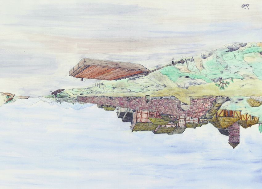
Fig. 8. Reconstruction of the Carolingian landing place of Großhöbing at the river
Schwarzach. Top: period 2, dated to 819 AD. Bottom: period 4, dated to 854/55 AD
(after Liebert 2015).
Like in Antiquity, river banks with an unfavorable ground have been
paved extensively with stone and wattle layers. The best example is a
mid-9th century landing place with a stone pavement excavated in
Großhöbing at the river Schwarzach (Liebert 2015, pp. 51-87). This
pavement (fig. 8) has been combined with wooden bank reinforcements
82PCA 7_2017_06-19.qxp_gao 6 30/06/17 10:12 Pagina 83
Medieval inland navigation and the shifting fluvial landscape between Rhine and Danube (Germany)
Fig. 9. Reconstruction of the canal construction of the Fossa Carolina dated to 793 AD
based on the excavation 2013 with an original oak pile of the bank reinforcement (drawing
F. Herzig, L. Werther).
which served as a simple quay to moor smaller ships. For bigger vessels,
this harbour at the limits of navigability of the river Schwarzach has not
been accessible, but the proximity to the European watershed made it a
perfect point of transshipment to reach the tributaries of the river Rhine
via a short portage (Liebert 2015, pp. 67-87).
It is obvious that bridging this watershed was of a particular impor-
tance already in the Early Middle Ages. This is clearly documented by the
attempt of Charlemagne to build an artificial canal in 793, the famous
Fossa Carolina (fig. 9) which should create a continuous waterway be-
tween Rhine and Danube (Ettel et al. 2014; zielhofer et al. 2014;
Werther et al. 2015). Intensive research in the last years indicates, that
at least the northern part of this ambitious project was almost finished
and ready to use. The excavated canal fairway with wooden bank stabi-
lizations (fig. 9) is 5,2-5,3 m wide, the minimal water depth was about
50 cm (Werther et al. 2015, pp. 156-173). The dimension of the fairway
is very similar to the 9th century artificially modified Schwarzach channel
at the harbour of Großhöbing (fig. 8; Liebert 2015, pp. 67-87). There-
fore, these fairways close to the watershed document the minimal re-
quirements for Carolingian vessels at the limits of navigation.
83PCA 7_2017_06-19.qxp_gao 6 30/06/17 10:12 Pagina 84
Lukas Werther, Lars Kröger
6. Bridges, fords and ferries: crossing the rivers Main and Regnitz
Watersheds between rivers have not been the only obstacles for me-
dieval traffic and communication. The rivers themselves have been an ob-
stacle, because crossing the river from one bank to the other, which has
been an essential part of everyday mobility not only of the elites but also
the general public (Elmshäuser 2002; Hägermann 2002), caused many
problems. If a longer river section was only crossable at a certain place,
traffic concentrated there. These bottlenecks often gained importance,
resulting in an increase of written sources – and they allow for a detailed
analysis concerning the connection between terrestrial routes and wa-
terways. Based on a PhD thesis on river crossings at Main and Neckar
this topic will be discussed in the last part of this article (see Kröger in
preparation with many more details).
The three main types of river crossings are bridges, fords and ferries,
but based on written sources a clear terminological distinction is not al-
ways possible – and also the distinction from harbours for navigation up-
stream and downstream is not always clear (see above). Due to the am-
biguous medieval terminology a separation between bridges and ferries
is especially problematic. Only in a few cases, it is clear that a crossing
was really a bridge und not a ferry service or “Schiffsbrücke” [i.e. boat
bridge]. The terminus pons/ponte is still in use for ferries nowadays in
some regions (Ellmers 1973, p. 53; see also Niermeyer, Kieft 2002, p.
3729). The mentioning of a navium dicti varbrucken in 1359 in Ochsen-
furt shows that variations of the term brucken/bridge have also been
used to describe a vessel crossing the river (Wenisch 1972, p. 42).
Furthermore, a separation between a ferry and a harbour for naviga-
tion along the river is in fact not possible, because every ferry station
consists of two small harbours or landing places (fig. 12). This ambigu-
ous character is also documented in the written sources, especially for
early and often very short mentions. To give an example, the bishop of
Würzburg is provided with a fiefdom for a naulum by Konrad II. in 1030,
which is translated as a ferry wage (Seberich 1958, pp. 16 and 157-
158), but it may also be a payment for other duties related to navigation
(Adam 1996, p. 53). In Kitzingen, the monastery gets fees for a portus
in 1070, which can be interpreted either as a ferry payment or a landing
place (Arnold 1996, pp. 25 and 46-47).
In some cases, especially if the sources are more detailed, bridges
can clearly be identified. In Antiquity, there have been several bridges in
the study area, but their usability in the Middle Ages is usually unclear
(Frohnhäuser 1870, p. 9; Steidl et al. 2008). In Mainz, Charlemagne
renovated the roman bridge crossing the Rhine, but it was destroyed by
84PCA 7_2017_06-19.qxp_gao 6 30/06/17 10:12 Pagina 85
Medieval inland navigation and the shifting fluvial landscape between Rhine and Danube (Germany)
Fig. 10. General map of medieval ferry stations and bridges at the rivers Main and Regnitz
from the beginning to the 13th century AD (status 2016; map data SRTM-GDEM ©
NASA 2009, CCM River and Catchment Database © European Commission 2007).
a fire soon and not rebuilt for centuries (Regesta Imperii RI I – Karolinger
n. 477a). There is no clear archaeological evidence for early medieval
bridges, but at least in Seligenstadt some undated remains may be from
this period (Fabricius 1914, pp. 3-4; Gündel 1933, pp. 137-138).
The oldest bridges at the rivers Main and Regnitz are mentioned in
the 10th century AD, until the 13th century they are documented in
Frankfurt, Aschaffenburg, Würzburg, Ochsenfurt, Kitzingen, Hochstadt,
Bamberg and Bruck (figs. 10, 11). In 989 the earliest source describes
a Pontem construxit apud Aschaffenburg (Fischer 1989, pp. 40-41). In
1020 the Bamberg bridge is first mentioned, the earliest archaeological
remains date to the 12th century (Menke 2009, pp. 111-112). In
Würzburg, a bridge constructed by the cathedrals master builder is first
mentioned in 1133 (Seberich 1958, pp. 16-21, 158-159). As discussed
for Schweinfurt above, the construction of a bridge had to be approved
by the king. Usually, the king did not give the right for a specific construc-
tion, but the right to cross the river at a certain place. Once such a right
has been granted, no new permissions have been necessary to rebuild
and repair a bridge, if it was destroyed e.g. by floods and ice drift. To
support the maintenance of bridges, special privileges for the supply of
building material such as wood have been granted by the king, for exam-
ple after the first destruction of the bridge in Frankfurt in 1235 (Gorr
1982, p. 77; Wissenbach 2010, pp. 11, 16).
85PCA 7_2017_06-19.qxp_gao 6 30/06/17 10:12 Pagina 86
Lukas Werther, Lars Kröger
River First
Name River Technique References
kilometer mention
Gustavsburg Main 1,3 Ferry 1283 Flug 2006
Flörsheim Main 11,8 Ferry 1250/60 Hoßbach, Großmann 2003
Wissenbach 2010
Frankfurt Main 35,6 Bridge 1222
Gorr 1982
Seligenstadt Main 69,5 Ferry 1289 Koch 1940
Aschaffenburg Main 87,5 Bridge 989 Fischer 1989
Obernburg Main 104,5 Ferry 1261 Fischer-Pache 1993
Wörth Main 110 Ferry 1282 Trost 1989
Lengfurt Main 174 Ferry 1102 Kuhn 2008
Steinbach Main 200 Ferry 1294 Höfling 1838
Würzburg Main 252,5 Ferry 1030 Seberich 1958
Würzburg Main 252,5 Bridge 1133 Seberich 1958
(Klein-)Ochsenfurt Main 271 Ferry 1103 Kampfmann 1990
Wenisch 1972
(Klein-)Ochsenfurt Main 271 Bridge 1246/47
Keyser, Stoob 1971
Kitzingen Main 286,8 Ferry ca. 1070 Arnold 1996
Kitzingen Main 286,8 Bridge 1300 Badel, Christof 2000
Haßfurt Main 361,7 Ferry 1275 Jäger 2010
Kemmern Main 400 Ferry 1248 Schrott 1986
Biegen/Baunach Main 403 Ferry 1296 Jakob 1960
Hochstadt Main 451 Bridge 1258 Müller 1990
Bamberg Regnitz 5 Bridge 1020 Menke 2009
Bruck Regnitz 51,4 Bridge 1282 Birkholz 2008
Fig. 11. Compilation of ferries and bridges at Main and Regnitz until 1300 AD (data col-
lection: L. Kröger).
Ferries are an important alternative to bridges and they have been
used frequently in the study area, as already discussed concerning log-
boats as parts of ferries proofed from the 7th century AD onwards at
the river Main (fig. 1, no. 47). Nevertheless, written sources about the
users of ferries, transported goods and technical facilities are very
scarce before the 13th century. In 1102, the monastery Triefenstein in
Lengfurt is provided with a ferry by the bishop of Würzburg (Kuhn 2008,
p. 171). It is very typical that the early sources have been written down
when ownership changed (e.g. Gustavsburg, 1283, Flug 2006, p. 203;
Seligenstadt, 1289, Koch 1940, p. 136). In contrast to the Early Mid-
dle Ages, later on ferries did no longer belong to the kings properties or
have been directly subordinated to him. Instead, local lords and institu-
86PCA 7_2017_06-19.qxp_gao 6 30/06/17 10:12 Pagina 87
Medieval inland navigation and the shifting fluvial landscape between Rhine and Danube (Germany)
tions – like the bishop of Würzburg – controlled them independently (see
Kröger in preparation). Once the ferry fiefdom was awarded, it could
have been given from one owner to another, which happened frequently.
To give an example, in 1103 the fiefdom of the ferry in Kleinochsenfurt
at the river Main is transferred by a local lord to the monastery of Hir-
sau, which he later joins. In 1150 the fiefdom was given to the priory
Schönrain near Gemünd and in 1251 to the monastery Neustadt near
Lohr (Kampfmann 1990, pp. 23-24). In rare occasions, specialists oper-
ating these ferries are also mentioned in the sources, e.g. Conradus dic-
tus Verhe [i.e. ferryman] de Werde in 1282 (Trost 1989, pp. 301-302).
With the increase of written sources from the end of the middle ages,
more information on the complex legal framework, taxing and daily rout-
ing of ferries is available, but projection to earlier periods is often prob-
lematic (see Kröger in preparation).
In addition to bridges and ferries, fords are an essential means of
crossing a river (see the comprehensive discussion in Kröger in prepara-
tion, we focus on selected issues here). Often fords are considered as
the oldest way to cross a river and therefore nuclei for later settle-
ments, but the meaning of the medieval term “ford” is not always clear
and alternative interpretations have to be discussed. Furthermore, fords
have also been a serious obstacle for traffic, especially for navigation. It
has been discussed, that medieval flat bottomed ships have only a small
draught, but still the river should have a minimum depth which is not al-
ways given at fords (Kröger 2014). Whereas a higher water depth was
therefore favourable for navigation, pedestrians had the opposite inter-
est, as crossing deeper rivers is not only uncomfortable, but also dan-
gerous. In 1830, Prussian officers have still been warned to walk their
troupes through rivers deeper than 78 cm, even with a stable ground
and slow current (Hoyer 1830a, pp. 76-77; Hoyer 1830b, pp. 58-76).
Geomorphological changes and seasonal hydrological variations caused
further problems for the use of fords – and for their localisation. Before
floodplain sedimentation increased significantly at the end of the Early
Middle Ages, the active channel of the river Main has been rather deeper
than later on (Fuchs et al. 2011; Schirmer 2007). Furthermore, even in
the post-medieval period no ford between Mainz and Bamberg has been
traversable all-the-year. In order to localise older fords at shallow sec-
tions of the river, usually place names with the suffix “Furt” [i.e. ford] are
the initial point and the main argument. From the 8th century onwards,
furtes are mentioned in written sources of the study area, like in a border
description of 779 AD for Heidingsfeld at the river Main (Borchardt
2005, p. 65), but usually the sources are significantly younger. Further-
87You can also read