Places for Everyone JPA22 Land North of Smithy Bridge Allocation Topic Paper July 2021 - Greater ...
←
→
Page content transcription
If your browser does not render page correctly, please read the page content below

Places for Everyone JPA22 Land North of Smithy Bridge Allocation Topic Paper July 2021
Contents
Section A – Background ........................................................................................................3

               Introduction ...........................................................................................................3

               Allocation Land North of Smithy Bridge Overview .................................................5

               Site Details ............................................................................................................5

               Proposed Development .........................................................................................6

               Site Selection ........................................................................................................6

               Planning History ....................................................................................................7

               GMSF 2019 Consultation Responses ...................................................................8

               GMSF 2019 Integrated Assessment .....................................................................9

               GMSF 2020 Integrated Assessment ................................................................... 11

Section B – Physical ............................................................................................................ 13

               Transport ............................................................................................................. 13

               Flood Risk and Drainage ..................................................................................... 16

               Ground Conditions .............................................................................................. 16

               Utilities................................................................................................................. 17

Section C – Environmental .................................................................................................. 18

               Green Belt Assessment....................................................................................... 18

               Green Infrastructure ............................................................................................ 20

               Recreation ........................................................................................................... 20

               Landscape........................................................................................................... 21

               Ecological/Biodiversity Assessment .................................................................... 21

               Habitat Regulation Assessment .......................................................................... 23

               Heritage Impact Assessment .............................................................................. 23

               Air Quality............................................................................................................ 25

               Noise ................................................................................................................... 25

Section D – Social ............................................................................................................... 26

               Education ............................................................................................................ 26

Site Allocation Topic Paper – JPA22 Land North of Smithy Bridge – PfE 2021
                                                                                                                                      1
Health .................................................................................................................. 26
Section E – Deliverability ..................................................................................................... 27
Viability ................................................................................................................ 27
Phasing ............................................................................................................... 27
Indicative Masterplanning.................................................................................... 27
Section F – Conclusion ........................................................................................................ 28
The Sustainability Appraisal ................................................................................ 28
The main changes to the Proposed Allocation .................................................... 28
Conclusion .......................................................................................................... 29
Section G – Appendices ...................................................................................................... 31
Section H – Bibliography ..................................................................................................... 42
Site Allocation Topic Paper – JPA22 Land North of Smithy Bridge – PfE 2021
2Section A – Background
Introduction
1.1 In November 2014, the AGMA Executive Board recommended to the 10 Greater
Manchester local authorities that they agree to prepare a joint Development Plan
Document (“Joint DPD”), called the Greater Manchester Spatial Framework
(“GMSF”) and that AGMA be appointed by the 10 authorities to prepare the GMSF
on their behalf.
1.2 The first draft of the GMSF DPD was published for consultation on 31st October
2016, ending on 16th January 2017. Following substantial re-drafting, a further
consultation on the Revised Draft GMSF took place between January and March
2019.
1.3 On the 30 October 2020 the AGMA Executive Board unanimously agreed to
recommend GMSF 2020 to the 10 Greater Manchester Councils for approval for
consultation at their Executives/Cabinets, and approval for submission to the
Secretary of State following the period for representations at their Council meetings.
1.4 At its Council meeting on 3 December Stockport Council resolved not to submit the
GMSF 2020 following the consultation period and at its Cabinet meeting on 4
December, it resolved not to publish the GMSF 2020 for consultation.
1.5 As a joint DPD of the 10 Greater Manchester authorities, the GMSF 2020 required
the approval of all 10 local authorities to proceed. The decisions of Stockport
Council/Cabinet therefore signalled the end of the GMSF as a joint plan of the 10.
1.6 Notwithstanding the decision of Stockport Council, the nine remaining districts
considered that the rationale for the preparation of a Joint DPD remained.
Consequently, at its meeting on the 11th December 2020, Members of the AGMA
Executive Committee agreed in principle to producing a joint DPD of the nine
remaining Greater Manchester (GM) districts. Subsequent to this meeting, each
district formally approved the establishment of a Joint Committee for the preparation
of a joint Development Plan Document of the nine districts.
Site Allocation Topic Paper – JPA22 Land North of Smithy Bridge – PfE 2021
31.7 Section 28 of the Planning and Compulsory Purchase Act 2004 and Regulation 32 of
the Town and Country Planning (Local Planning) (England) Regulations 2012 enable
a joint plan to continue to progress in the event of one of the local authorities
withdrawing, provided that the plan has ‘substantially the same effect’ on the
remaining authorities as the original joint plan. The joint plan of the nine GM districts
has been prepared on this basis.
1.8 In view of this, it follows that PfE should be considered as, in effect, the same Plan
as the GMSF, albeit without one of the districts (Stockport). Therefore “the plan” and
its proposals are in effect one and the same. Its content has changed over time
through the iterative process of plan making, but its purpose has not. Consequently,
the Plan is proceeding directly to Publication stage under Regulation 19 of the Town
and Country Planning (Local Planning) England Regulations 2012.
1.9 Four consultations took place in relation to the GMSF. The first, in November 2014
was on the scope of the plan and the initial evidence base, the second in November
2015, was on the vision, strategy and strategic growth options, and the third, on a
Draft Plan in October 2016.
1.10 The fourth and most recent consultation on The Greater Manchester Plan for Homes,
Jobs and the Environment: the Greater Manchester Spatial Framework Revised
Draft 2019 (GMSF 2019) took place in 2019. It received over 17,000 responses. The
responses received informed the production of GMSF 2020. The withdrawal of
Stockport Council in December 2020 prevented GMSF 2020 proceeding to
Regulation 19 Publication stage and instead work was undertaken to prepare PfE
2021.
1.11 Where a local planning authority withdraws from a joint plan and that plan continues
to have substantially the same effect as the original joint plan on the remaining
authorities, s28(7) of the Planning and Compulsory Purchase Act 2004 provides that
any step taken in relation to the plan must be treated as a step taken by the
remaining authorities for the purposes of the joint plan. On this basis, it is proposed
to proceed directly to Publication stage under Regulation 19 of the Town and
Country Planning (Local Planning) England Regulations 2012.
Site Allocation Topic Paper – JPA22 Land North of Smithy Bridge – PfE 2021
41.12 A comprehensive evidence base was assembled to support the policies and
proposals in the GMSF 2020. Given the basis on which the Plan has been prepared,
this evidence base remains the fundamental basis for the PfE 2021and has
remained available on the GMCA’s website since October 2020. That said, this
evidence base has been reviewed and updated in the light of the change from GMSF
2020 to the PfE2021 and, where appropriate, addendum reports have been
produced and should be read in conjunction with evidence base made available in
October 2020. The evidence documents which have informed the plan are available
via the GMCA’s website.
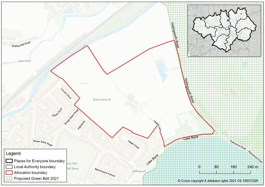
Allocation Land North of Smithy Bridge Overview
2.1 This site provides an excellent opportunity to deliver a high quality housing scheme
and associated facilities which maximises the potential of this sustainable location.
Located in an attractive setting, adjacent to Hollingworth Lake and the Rochdale
Canal, the site provides an opportunity to deliver a landscape-led development which
maximises its Pennine fringe setting and takes account of views from and into the
site.
Site Details
3.1 The site is 20.4ha in size and is bounded by Lake Bank to the south, Hollingworth
road to the east, Rochdale Canal to the north and Smithy Bridge to the west.
3.2 This is a greenfield site that falls within the Green Belt adjacent to Hollingworth Lake
and the Rochdale Canal which both provide high landscape value and provides
some attractive recreational routes.
3.3 The site is within walking distance of both Littleborough and Smithy Bridge rail
stations and adjacent to the residential area of Smithy Bridge. The site is also close
to Littleborough town centre which contains a range of local services and facilities.
Site Allocation Topic Paper – JPA22 Land North of Smithy Bridge – PfE 2021
5Proposed Development
4.1 The site will deliver around 300 new homes to meet to needs within the local area,
including larger, higher value properties to attract and retain higher income
households within the plan area.
4.2 Access between the site, Hollingworth Lake, Rochdale Canal, the two railway
stations and Littleborough town centre will be significantly improved through the
creation of high quality, safe and convenient walking and cycling routes though the
site.
4.3 Development will facilitate the delivery of a new primary school and associated
outdoor playing space at the southern end of the site and contribute to additional
primary and secondary school places to meet demand arising from the new
development as well as existing demand within the local area.
4.4 The southern end of the site is currently occupied by a car park which
accommodates visitors to the lake. Any proposal will need to ensure the provision of
a replacement visitor car park to replace the existing spaces lost on this car park.
Site Selection
5.1 To identify potential development sites for allocation a Site Selection methodology
has been developed. The purpose of the Site Selection methodology is to identify the
most sustainable locations for residential and employment development that can
achieve the Places for Everyone (PfE), referred to as ‘the Plan’, Vision, Objective
and Spatial Strategy and meet the housing and employment land supply shortfall
across the plan area.
5.2 The methodology includes seven Site Selection criteria. Based on the Plan Spatial
Strategy, plan objectives and guidance in the NPPF on Green Belt release these
seven Site Selection Criteria have been developed to identify the most sustainable
sites in the Green Belt. This site satisfies criteria 1 ’Land which has been previously
developed and/or land which is well served by public transport’ and criteria 7 ‘Deliver
significant local benefits by addressing a major local problem/issue’.
Site Allocation Topic Paper – JPA22 Land North of Smithy Bridge – PfE 2021
65.3 Criterion 1 relates to sites located in sustainable and accessible locations which are
already well served by public transport. The site is within walking distance of both
Littleborough and Smithy Bridge rail stations. The site is also close to Littleborough
town centre which contains a range of local services and facilities, including access
to a high frequency bus service.
5.4 Criterion 7 relates to sites which can demonstrate direct links to addressing a specific
local need. There is a strong market demand for housing within the area of
Littleborough. It is one of the most significant areas of larger, higher value housing
within the borough and is considered to be a desirable and aspirational place to live.
This is a deliverable housing site that provides the opportunity to capitalise on an
existing high end market housing area to deliver a type of housing which is in short
supply across the borough and the conurbation as a whole. The provision of such
housing is important to ensure that a good range of housing is available across the
plan area to support economic growth. This site will also deliver a primary school
which will meet the needs of the development as well as addressing needs for school
places in the wider area.
5.5 Central to the Spatial Strategy is to deliver inclusive growth across the city-region. To
assist in the delivery of this the Plan identifies a number of broad areas and
opportunities which will mean that the plan area can achieve the levels of new
growth required to meet its needs whilst securing genuinely inclusive growth and
prosperity. One of these opportunities is to boost significantly the competitiveness of
northern parts of the plan area. This site fits with the Spatial Strategy by providing
the opportunity for deliverable large scale residential development in the north of the
plan area.
5.6 For further detail please see the Site Selection Topic Paper.
Planning History
6.1 A screening opinion in relation to a residential development of 350 dwellings, a
primary school and associated works (19/00910/SO) was submitted in August 2019.
The decision in January 2020 was that an Environmental Impact Assessment (EIA)
was required. .
Site Allocation Topic Paper – JPA22 Land North of Smithy Bridge – PfE 2021
7GMSF 2019 Consultation Responses
7.1 Many of the comments were objecting to any development at Smithy Bridge with
many respondents concerned that the types of housing proposed was not
appropriate for the area. However there was also some support from respondents
who felt that this is a good, sustainable site to redevelop. There was support for
increasing the housing offering within this area, particularly to include executive
housing which is lacking and in demand. Some respondents stated they have had to
move out of the area as there was a lack of high quality homes available.
7.2 There was a lot of objection to the loss of Green Belt land with more focus needing to
be given to developing brownfield land as a priority. There is also concern that the
number of houses being allocated for the size of the village is too high and
disproportionate and more focus should be on addressing the local housing need,
such as affordable and older persons housing, rather than high value housing.
7.3 Several respondents objected to the impact on Hollingworth Lake and the bearing it
would have on it as a tourist attraction and area of natural beauty. Many respondents
felt that the development would negatively impact wildlife, the overall perception of
the area as a rural setting and that the enhancement of green and blue infrastructure
of the area needs further consideration. Some respondents felt that Hollingworth
Lake should be enhanced for tourism purposes and this site could be better utilised
to contribute to this, by providing better leisure facilities or further off road parking.
7.4 The increased traffic which will result from the development is a key area of concern
for many respondents. Many felt the existing road network is inadequate, heavily
congested and will not be able to cope with increased demand. The perceived heavy
congestion is considered to be further exacerbated by the level crossing closing
several times each hour. Concerns were raised regarding the emergency vehicle
response times for this area already being above the national average and the
negative impact further traffic will have on this. Parking for the Lake was also
highlighted as problematic, particularly during nice weather, bank holidays and
weekends.
Site Allocation Topic Paper – JPA22 Land North of Smithy Bridge – PfE 2021
87.5 There is an existing issue with school places for this area. Many respondents stated
that schools were oversubscribed with many children having to travel long distances
to attend school. The proposed primary school is welcomed, however there is a
particular issue with secondary school places and many respondents felt that this
also needs addressing.
7.6 For further detail please see the Places for Everyone Consultation Summary Report.
GMSF 2019 Integrated Assessment
8.1 The GMCA commissioned ARUP to complete an Integrated Assessment (IA) of the
first and second draft of the GMSF and the 2021 PfE.
8.2 The IA is a key component of the evidence base, ensuring that sustainability,
environmental, quality and health issues are addressed during its preparation. The IA
combines the requirements and processes of the Sustainability Appraisal, Strategic
Environmental Assessment, Equality Impact Assessment and the Health Impact
Assessment into one document. The IA carries out an assessment of the draft
policies by testing the potential impacts and consideration of alternatives against the
plans objectives and policies. This ensures that any potential impacts on the aim of
achieving sustainable development considered and that adequate mitigation and
monitoring mechanisms are implemented.
8.3 The 2020 IA contributes to the development of the Plan polices. It does this through
an iterative assessment, which reviews the draft policies and the discrete site
allocations against the IA framework. Stakeholder consultation is a significant part of
the IA, and opinions and inputs from stakeholders have been sought on previous
iterations and will be sought on this 2020 IA, as part of the consultation on the 2021
PfE.
8.4 The draft GMSF and the accompanying IA were published for consultation in
January 2019. The comments received that are specific to the 2020 IA, as identified
by the GMCA, informed the 2020 update of the IA Scoping Report and the 2020 IA.
Site Allocation Topic Paper – JPA22 Land North of Smithy Bridge – PfE 2021
98.5 The 2019 draft GMSF included a number of revised and new thematic policies and a
number of different allocations from the 2016 draft GMSF. It took on board the
consultation responses received on the allocations. This was reflected within the IA
of the allocations. The SFRA has been completed and the exceptions test was taken
into account as mitigation in the 2019 IA.
8.6 Spatial Options and Reasonable Alternatives were assessed for the 2019 draft
GMSF by GM Districts and GMCA officers and made available in a separate report.
It is noted that the 2020 Growth and Spatial Options Report has also been assessed
as part of this IA process, and again, is made available as a separate report.
8.7 Comments received during the 2019 consultation included: proposing alternative
scoring for thematic and site allocation policies, reviewing the IA objectives and the
GMSF strategic objectives and the connection with the Habitats Regulations
Assessment.
8.8 The 2020 IA process has taken into consideration the comments received in the light
of the emerging evidence in the main IA report and Appendices. A summary of the
2019 consultation feedback relevant to the 2020 IA and response to those comments
is included in Appendix A of the 2020 IA report. They will form part of the Post
Adoption Statement.
8.9 The key outcomes of the 2019 IA assessment on the Land North of Smithy Bridge
allocation policy in the 2019 Draft GMSF have been considered to inform the
production of the revised JP Allocation 22. This has been reassessed in the 2020 IA.
Appendix D of the 2020 IA provides the assessment tables for each allocation policy.
It includes the assessment from 2019 including mitigation proposed, commentary on
changes since 2019 and how this responds to the recommendations. Finally, it
details any residual recommendations.
8.10 It is important to note that the IA was focusing on each policy in isolation from other
policies in the Plan and that many of the recommended changes for the Land North
of Smithy Bridge allocation policy are already covered in other policies in the Plan.
However some changes have been made to the Land North of Smithy Bridge
Site Allocation Topic Paper – JPA22 Land North of Smithy Bridge – PfE 2021
10allocation policy as a result of the 2019 IA and the policy has been reassessed in the
2020 IA.
8.11 Further details can be found in the PfE Integrated Appraisal Report and PfE
Integrated Appraisal Addendum Report.
GMSF 2020 Integrated Assessment
9.1 As mentioned above the key outcomes of the 2019 IA assessment on the Land North
of Smithy Bridge allocation policy in the 2019 Draft GMSF have been considered to
inform the production of the revised JP Allocation 22. This has been reassessed in
the 2020 IA. Appendix D of the 2020 IA provides the assessment tables for each
allocation policy. It includes the assessment from 2019 including mitigation
proposed, commentary on changes since 2019 and how this responds to the
recommendations. Finally, it details any residual recommendations. A summary of
the assessment for JP Allocation 22 can be found below.
9.2 Each site allocation policy has been appraised using the IA framework. The
allocation policies primarily focus on the site-specific topics and therefore some of
the IA objectives which are less relevant for most allocations or more appropriate to
assess in the thematic policies have been picked up in the IA of the thematic
policies.
9.3 The policy performed negatively against provision of healthcare facilities. The
recommendations made against this IA objective are addressed within policies JP-P
5, JP-P 6 and JP-P 7 and therefore no changes were made to JP allocation policy
22.
9.4 The policy performed negatively against ensuring that land resources are used in an
efficient way because the site is greenfield and so therefore it does not support
criteria relating to the development of previously developed land, protecting
best/most versatile agricultural land or encouraging development of
derelict/contaminated land. The recommendations made against this IA objective are
addressed within policies JP-G8 and JP-G9 and therefore no changes were made to
JP allocation policy 22. The Plan acknowledges that given the overall scale of
Site Allocation Topic Paper – JPA22 Land North of Smithy Bridge – PfE 2021
11development that needs to be accommodated, development on some greenfield land
is necessary as it is critical to the delivery of wider development proposals.
9.5 The policy performed positively or neutral against all the other IA objectives.
9.6 Further details can be found in the PfE Integrated Appraisal Report and PfE
Integrated Appraisal Addendum Report.
Site Allocation Topic Paper – JPA22 Land North of Smithy Bridge – PfE 2021
12Section B – Physical
Transport
10.1 The Locality Assessment for this allocation assessed the impact of the trips in 2025
and 2040 that could be generated on the network, both without and with mitigation
measures. The outcomes concluded that the allocations did not have a severe
impact on either strategic or local networks but mitigation works were required on the
local network to ensure this.
10.2 The analysis of this allocation was combined with that for the GM25 Roch Valley
allocation, with mitigation measures being shared between the two allocations
according to their level of impact on the transport network. Where both allocations
had an effect, the mitigation costs were apportioned according to their modelled level
of impact.
10.3 The mitigation measures identified were:-
• Provide a 3-arm roundabout on Hollingworth Road to access the allocation;
• Contribute to a proposed A58 Residential Relief Road (Smithy Bridge Road to
Riverside Drive);
• A58 Local improvements to junctions with Smithy Bridge Road, Birch Road
and Albert Royds Street;
• A58 Halifax Road / B6225 Hollingworth Road signal co-ordination with A58
Halifax Road / A6033 Todmorden Road;
• Signalise A58 Wardle Road junction and in-bound free flow;
• Provide 300 space Hollingworth Lake visitor car park to replace existing facility
lost to the land allocation;
• Traffic Calming and Parking Management measures on Hollingworth Road;
• Provide secure cycle parking at Littleborough Railway Station;
• Upgrade 3 bus stops (2 on Hollingworth Road and 1 on Lake Bank).
10.4 It is proposed to access this allocation from B6225 Hollingworth Road via a 3-arm
roundabout subject to capacity requirements and detailed design. This also provides
a degree of traffic calming, with further traffic management and parking management
works (the latter already implemented) on Hollingworth Road. A secondary
Site Allocation Topic Paper – JPA22 Land North of Smithy Bridge – PfE 2021
13emergency access via Lake Bank (using Heald Lane) and other adjacent residential
routes will provide a link to Smithy Bridge Railway Station. These routes will also
provide a walking and cycling route with Lake Bank (via Heald Lane).
10.5 Through the planning application process, further work will take place to create
convenient high quality pedestrian and cycle links through the allocation between the
residential and Primary School elements of the allocation, and provide links to
Littleborough Town Centre, Hollingworth Lake and Littleborough as well as Smithy
Bridge Railway Stations. These should also link to the existing walking and cycling
network, and utilise and enhance the existing Public Rights of Way Network.
10.6 The allocation will finance a replacement visitor car park of around 300 spaces,
replacing those currently on the allocation and on-street spaces lost on Hollingworth
Road following the implementation of parking restrictions. A contribution will also be
sought to provide additional cycle parking spaces at Littleborough Railway Station.
10.7 The allocation is equidistant (around 600 metres) from both Smithy Bridge and
Littleborough Stations on the Calder Valley Line, both served by half hourly services
westbound to Rochdale and Manchester and east towards Leeds. Some additional
services operate in both directions during peak times. The nearest bus stops are
located on B6225 Hollingworth Road served by an hourly service to Rochdale and
Littleborough. These stops together with a stop on Lake Bank will be upgraded to
Quality Bus Corridor or equivalent standards. Consideration will be given to provide
or divert another service. Bus services run more frequently along the A58 with 5 or 6
services an hour to Rochdale and 7 services an hour to Littleborough, one of which
continues east to serve Burnley and Halifax.
10.8 The Locality Assessment indicates that the limited choice of routes serving this part
of the Borough and the combined impact of the trips generated from this allocation
and GM25, will affect the operation of junctions across the wider network. Junctions
along the A58 with Smithy Bridge Road, Birch Road and Albert Royds Street have
been identified along with potential signalisation of the junction with Wardle Road.
Mitigation costs to address the traffic impact at these junctions will be apportioned
between this and GM25 proposed GMSF allocations.
Site Allocation Topic Paper – JPA22 Land North of Smithy Bridge – PfE 2021
1410.9 A significant number of commuter journeys are generated in this part of the Borough.
This is illustrated by the number of passengers using Littleborough and Smithy
Bridge Railway stations at peak times, and the volume of traffic using routes to
access the M62 junction 21. The A58 Residential Relief Road proposal primarily
seeks to address delays on A58 Halifax Road, but initial modelling shows that it
delivers noticeable reductions in junction delays in Milnrow for these trips and those
generated by proposed allocations to get to and from the M62.
10.10 The A58 Residential Relief Road will provide an alternative local route that will also
access the GM25 Roch Valley allocation. It will also form part of the Bee Network
and incorporate “Streets for All” principles incorporating speed restrictions and traffic
management measures. It will provide a release valve and an additional choice of
route for peak time traffic. The eastern section of the route will be delivered as part of
GM25 allocation access arrangements with a contribution from this allocation
towards the route construction. These third party contributions will provide matched
funding to secure other sources of finance to deliver the remainder of the Residential
Relief Road.
10.11 This allocation will have a significant impact on the signalised junctions in the centre
of Littleborough. The A58 Halifax Road / B6225 Hollingworth Road and A58 Halifax
Road / A6033 Todmorden Road are located close together and, particularly at peak
times, their operation could be improved with better co-ordination of the signals. This
will offer only an interim solution and so wider proposals are being explored to
reduce peak time delays in the long term at these junctions.
10.12 The Locality Assessment and proposed mitigation measures for this allocation were
reviewed between May and July 2021. The outcome was that the Locality
Assessment for the Land North of Smithy Bridge allocation remained robust with the
traffic impacts remaining less than severe. The proposed mitigation measures
remain deliverable and no re-phasing of the mitigation interventions are necessary.
Site Allocation Topic Paper – JPA22 Land North of Smithy Bridge – PfE 2021
15Flood Risk and Drainage
11.1 The GMCA has applied the flood risk Sequential Test in the preparation of the Plan
as required by the National Planning Policy Framework. Further details of the
process undertaken by the GMCA can be found in the document ‘Greater
Manchester Spatial Framework 2020 – Flood Risk Sequential Test and Exception
Test Evidence Paper’ (October 2020).
11.2 The Greater Manchester Level 1 Strategic Flood Risk Assessment (GM SFRA) was
completed in March 2019. It updates and brings together the evidence base on flood
risk in Greater Manchester including the impact of climate change on flood risk.
11.3 All allocations have been screened against Environment Agency mapping and
datasets and recommendations were produced for each site based on the screening
assessment and its review of the extent and severity of flood risk and the
vulnerability of the proposed site use.
11.4 It was concluded that any flood risk affecting this allocation can be appropriately
addressed through consideration of site layout and design as part of a detailed Flood
Risk Assessment or Drainage Strategy at the planning application stage. Therefore
no further assessment is required at this time through the GM SFRA.
Ground Conditions
12.1 A desk based review of the site has been undertaken by the Council’s Public
Protection Service. The findings of this are summarised as follows:
• Site currently comprises open land which has been subject to groundworks
• Possible contaminating features, infilled water features on site including
reservoir in the centre, former quarry near NW border, former chemical,
colliery and other industrial facilities immediately north of the site (Akzo)
• A number of known landfills to the east, north and west of the site
• The department has records of ground investigations which have been
undertaken in the north east and immediately north of the site
• Minor aquifer, area to the NW and SE of site identified as a flood zone
• Drift geology comprises Glacial Till, solid the Milnrow Sandstone and Coal
Measures
Site Allocation Topic Paper – JPA22 Land North of Smithy Bridge – PfE 2021
16• Class 1 radon area which would not have any impact on development.
12.2 The main issue from the above relates to the previous use of the land around the site
which means that an intrusive investigation is likely to be required to establish if and
what remedial techniques are necessary to ensure the site is suitable for its intended
end use. This would be a condition relating to any future planning approval and is
common is respect of sites which have or are adjacent to sites that have had an
industrial use.
12.3 A Screening Opinion has been previously submitted for this site by the site promoter
and some work has already been undertaken in respect of ground conditions. The
schedule submitted alongside the screening application identified a number of issues
that would be addressed appropriately through further studies and assessments at
the planning application stage.
Utilities
13.1 There are no known constraints in respect to utilities on the site. The site is
immediately adjacent to a long-standing developed area where a range of services
are available. This will include water, gas and electricity mains, alongside
telecommunications infrastructure. The development can therefore be easily
connected to key utilities. Any upgrades required to accommodate new homes can
be made alongside the delivery of the development.
Site Allocation Topic Paper – JPA22 Land North of Smithy Bridge – PfE 2021
17Section C – Environmental
Green Belt Assessment
14.1 Development of the site will result in the loss of 18.4ha of Green Belt land.
14.2 GMCA commissioned LUC to undertake an assessment of the Green Belt within GM.
The Study assessed the extent to which the land within the GM Green Belt performs
against the purposes of Green Belts, as set out in paragraph 80 of the National
Planning Policy Framework (NPPF). The aim of this Green Belt Assessment is to
provide the GM Authorities with an objective, evidence-based and independent
assessment of how GM’s Green Belt contributes to the five purposes of Green Belt,
as set out in national policy. It also examines the case for including within the Green
Belt potential additional areas of land that currently lie outside it.
14.3 The table below presents the assessment ratings for the parcel of land that Land
North of Smithy Bridge falls within:
Parcel Reference RD20
Purpose 1a Rating Moderate
Purpose 1b Rating Moderate
Purpose 2 Rating Strong
Purpose 3 Rating Moderate
Purpose 4 Rating Strong
Strategic Green Belt Area 16
14.4 Further details can be found in the Greater Manchester Green Belt Assessment.
14.5 The GM GB Harm Assessment identifies that the allocation makes a moderate
contribution to checking the sprawl of Greater Manchester (purpose 1) and
preventing encroachment of the countryside (purpose 3), as well as a relatively
limited contribution to maintaining separation between Smithy Bridge and
Littleborough (purpose 2). The Allocation also makes a relatively limited contribution
to preserving the settlement of Littleborough (purpose 4).
Site Allocation Topic Paper – JPA22 Land North of Smithy Bridge – PfE 2021
1814.6 The assessment adds that the release of the allocation would constitute moderate
harm to Green Belt purposes, would increase the containment by inset development
of retained Green Belt land to the north but would only have a minor impact on
adjacent Green Belt.
14.7 In terms of cumulative harm, the release of this land would only have no/limited
impact on the contribution that SGBA 16 makes to checking unrestricted sprawl
(purpose 1) and separation of towns (purpose 2) due to its containment and the
existence of physical boundaries. The allocation itself would encroach into the
countryside but would have little impact on the contribution the SGBA makes to the
purposes of the Green Belt. Release of allocation GM23 could detract from the
setting of Littleborough to a limited extent.
14.8 Release of the allocation would not increase the containment of retained Green Belt
land and would not weaken the strength of the Green Belt boundary. The allocation
has strong defensible boundaries to the Green Belt to the south and east in the form
of Lake Bank and Hollingworth Road.
14.9 Whilst the assessment concludes that its release would result in some harm to the
Green Belt the Council considers that the benefits of the proposed allocation
significantly outweigh its overall harm, including its Green Belt harm, representing
exceptional circumstances in accordance with national planning policy. The
exceptional circumstances are set out in the Green Belt Topic Paper. These relate
to the Site Selection criteria along with other relevant issues and are as follows:
• The site meets Criterion 1 of the Site Selection criteria, as the site is located
between Smithy Bridge and Littleborough railway stations, is within walking
distance of Littleborough town centre and is adjacent to the Rochdale Canal
which provide active travel opportunities
• The site meets Criterion 7 of the Site Selection criteria, as it provides an
opportunity to deliver a high quality development providing a type of housing
which is in short supply across the borough and the conurbation as a whole
and therefore make a positive contribution to boosting the competitiveness of
the north of the plan area.
Site Allocation Topic Paper – JPA22 Land North of Smithy Bridge – PfE 2021
19• The development will facilitate the delivery of a new primary school which will
provide much needed places locally to serve the needs of the wider area as
well as those arising from the new development.
14.10 The GM Green Belt Study - Identification of Opportunities to Enhance the Beneficial
Use of the Green Belt report also identifies a range of opportunities to enhance the
beneficial use of remaining Green Belt. These will be considered in relation to the
Council’s own Local Plan and priorities for green infrastructure improvements in the
wider area.
Green Infrastructure
15.1 The setting and topography of this site lends itself to the delivery of a high quality
green and blue infrastructure network as part of a comprehensive scheme. Green
infrastructure within the site can also utilise existing natural features and field
boundaries to deliver a development which has regard to the existing site.
15.2 The site is adjacent to Hollingworth Lake Country Park and therefore landscaping
and boundary treatments will be important to create a high quality environment for
both the existing and new development.
15.3 The need for good quality green and blue infrastructure is set out in the policy and
will guide masterplanning on the site. The policy also references the important role
this site plays helping to create attractive and safe pedestrian and cycle connections
between Littleborough town centre and Hollingworth Lake Country park.
15.4 The approach to green infrastructure and the creation of routes should have regard
to both the proposed development to the north (former Akzo site) and the adjacent
canal.
Recreation
16.1 Local policies and the associated Supplementary Planning Document set out the
requirements for both formal sports provision and children’s play / local open space.
The proposed development will be required to meet these requirements.
Site Allocation Topic Paper – JPA22 Land North of Smithy Bridge – PfE 2021
2016.2 In terms of the children’s play / local open space this will be expected to be provided
within the site as part of the requirement set out in the policy to deliver an integrated
green and blue infrastructure network within the scheme. As noted above, green
infrastructure would be expected to provide good quality pedestrian and cycle routes
and seek opportunities to deliver improvements to local biodiversity.
16.3 In terms of formal sports provision, given the size of the site, this would likely be
dealt with through off-site provision/contributions.
Landscape
17.1 The Vision Document submitted by the site promoter notes that the site is situated on
an area of land which is highly variable in topography, with land falling away from a
central ridge through the site to the east, and dropping steeply towards the Rochdale
Canal to the north and rising to the west to a plateau. This variable topography is
characteristic of the surrounding landscape. The site is also characterised by
scattered tree and woodland cover, improved grassland, varied styles of enclosure
including dry stone walls and hedgerows, and scattered farmsteads. It is traversed
by several public rights of way and has urban edge characteristics to the west.
17.2 Criterion 3 of the policy for this allocation states that the development of the site
should deliver a landscape-led development which maximises its Pennine fringe
setting and takes account of views from and into the site.
17.3 This requirement is acknowledged in the Vision Documents which set out possible
measures to preserve landscape value including enhancements to boundary
planting, the retention of the exposed ridge through the site as a green corridor and
recreational route and the opportunities to integrate internal field boundaries and
patterns of enclosure into the development
Ecological/Biodiversity Assessment
18.1 The Greater Manchester Ecology Unit (GMEU) have undertaken preliminary
ecological appraisals / screening for all of the Rochdale allocations proposed in the
Plan. An update of initial site appraisals was completed in September 2020 and are
Site Allocation Topic Paper – JPA22 Land North of Smithy Bridge – PfE 2021
21included in the Preliminary Ecological Appraisals - Screening - Rochdale Strategic
Allocations Sept 2020 report.
18.2 The aim of preliminary surveys is not to provide a fully comprehensive suite of
ecology surveys for sites, but rather to identify sites where ecological constraints to
future development are likely to prove significant. The findings of the appraisal for
this site are as follows:
• The site is within 100m of the Rochdale Canal which is a Special Area for
Conservation (SAC) and Site of Special Scientific Interest (SSSI) and therefore
would require a Habitats Regulation Assessment HRA;
• The canal is also a Local Wildlife Site;
• Ponds on the site could support great crested newts and water voles;
• In terms of specially protected species the site provides reasonable foraging
habitat for bats and barn owls and the buildings could support roosting bats.
Reasonable Badger habitat; and
• The site supports, or has the potential to support, priority habitat types including
ponds and hedgerows and priority species including farmland birds such as
linnet, reed bunting and barn owl as well as common toads.
18.3 The appraisal finds that the site itself is not designated at any level for its nature
conservation value but it does have potential to support priority habitats and species
and it is very close to the Rochdale Canal SAC. As a result of this proximity and the
overarching HRA undertaken in relation to the GMSF, a criterion has been added to
the policy which requires a project specific Habitats Regulation Assessment for
planning applications of 50 dwellings or more to be carried out. However, currently
there are no known ecological constraints which are so important as to preclude the
allocation of the site, but ecological mitigation and compensation will likely be
needed to avoid harm to important habitats and species.
18.4 The site promoters have undertaken their own ecological appraisal which is
summarised within their Vision Document. This appraisal identifies broadly similar
ecological constraints in terms of habitats and species. It anticipates that any
required mitigation can be accommodated within the extensive green infrastructure
(GI) proposals within the site. It adds that the scheme can be designed in a way that
Site Allocation Topic Paper – JPA22 Land North of Smithy Bridge – PfE 2021
22retains and enhances those features of highest ecological value, including the pond,
dry stone walls and hedgerows. Anticipated losses of any trees would be mitigated
through the planting of native trees and shrubs within the site, with the aim of
providing a net gain in biodiversity in accordance with the principles of the
Framework.
Habitat Regulation Assessment
19.1 Since the 2019 consultation the GMCA have engaged with Natural England in the
preparation of the Plan, including in the preparation of the Habitats Regulations
Assessment (HRA). The HRA must be undertaken in accordance with
the Conservation of Habitats and Species Regulations 2017 (as amended) to
determine if a plan or project may affect the protected features of a European
protected site.
19.2 The GMCA held one informal meeting in 2019 and two formal meetings with Natural
England through its Development Advisory Service in 2020 to consider the HRA.
GMCA has shared a draft version of the HRA (updated since 2019) with Natural
England for review and comment.
19.3 The GMCA and TfGM are responding to Natural England’s comments on the draft
HRA by commissioning additional air quality modelling to more accurately assess the
implications of changes in air quality on European sites that could potentially be
affected by changes to nitrogen levels arising from changes in vehicle movements in
Greater Manchester or within close proximity of the Greater Manchester boundary.
The GMCA are also responding to Natural England’s comments on functionally
linked land, recreation disturbances, water pollution and in-combination effects.
Details of this is included in the HRA and Assessment of Air Quality Impacts on
Designated Sites report.
Heritage Impact Assessment
20.1 The University of Salford completed a Heritage Impact Assessment which
highlighted the need for further evaluation. In alignment with the recommendations
made in the initial Heritage Impact Assessment a more comprehensive Smithy
Bridge Historic Environment Assessment has now been completed which has
Site Allocation Topic Paper – JPA22 Land North of Smithy Bridge – PfE 2021
23explored in detail the potential impact development could have upon any
archaeological interests of the site, heritage assets in or around the site and the
historic landscape within which the site is located.
20.2 The assessment has provided recommendations to ensure the significance of the
historic built and natural environment can be preserved or enhanced. These are
summarised below and can be found in full within the Smithy Bridge Historic
Environment Assessment.
20.3 Archaeology recommendation summary:
• To explore areas identified as potential locations for pre-historic activity,
workers’ cottages and some small areas of disturbance. A programme of
archaeological evaluation to be devised and implemented across the site.
20.4 In response to the above recommendations the policy has been amended to include
more specific criteria and supplementary information has been included within the
reasoned justification.
20.5 Built Heritage recommendations summary:
• Historic buildings at Lower Cleggswood Farm should be retained to preserve
the character of the local area. The development should include a buffer zone
around the farm and avoid being overly dominant development; plan and
design should respect the rural setting.
20.6 In response to the above recommendations, supplementary information has been
included within the reasoned justification.
20.7 Historic Landscape recommendations summary:
• To preserve the character of the area historic field boundaries and public paths
should be retained and incorporated into the development plan.
• Identification of the opportunity to create community wildlife pond at the former
reservoir.
Site Allocation Topic Paper – JPA22 Land North of Smithy Bridge – PfE 2021
2420.8 In response to the above recommendations, supplementary information has been
included within the reasoned justification.
Air Quality
21.1 A future planning application for the proposed allocation will be supported by an Air
Quality Statement / Assessment (AQS / AQA). This will be based on the Institute of
Air Quality Management (IAQM) Guidance, and consistent with the Draft Greater
Manchester Clean Air Plan. The AQS / AQA will assess the impacts of NO 2 , and
PM 10 , PM 2.5 particulate emissions from both the demolition / construction and
operational phases of the proposal. It will also assess the impact on human heath,
sites of ecological importance and sensitive receptors as well as the GM Air Quality
Management Area (AQMA) and prepare an action plan of measures to mitigate any
adverse impacts of the proposed allocation.
Noise
22.1 Given the location of the site in close proximity to the railway line it is likely that an
assessment relating to noise will be required at planning application stage. It is not
anticipated that this would present a major constraint on development.
22.2 The Vision Document provided by the site promoters summarises some initial work
that has been undertaken in terms of noise. This concludes that it is unlikely that
there would be a significant impact from railway associated noise within the
development site. Furthermore, based on the concept masterplan for the site at this
stage, it is likely that there will be a large stand-off area (public open space) between
the residential dwellings and the railway line; the topography of this area would also
provide a natural screen from the railway and further reduce the potential for noise
and vibration impacts.
Site Allocation Topic Paper – JPA22 Land North of Smithy Bridge – PfE 2021
25Section D – Social
Education
23.1 There is a local issue in terms of primary school places and this can only be resolved
through the provision of a new school. This area provides an excellent location for a
new facility given that it lies between Littleborough and Smithy Bridge and therefore
can serve both areas sustainably. It also provides an attractive location for a school
which can provide access to open areas and activities, thus promoting healthier
lifestyles.
23.2 The site will provide a new primary school and associated outdoor playing space at
the southern end of the site and contribute to additional secondary school places to
meet demand arising from the new development as well as existing demand within
the local area.
23.3 Secondary School provision within the borough is being enhanced through the
delivery of two new secondary schools which have recently been awarded
Government funding. One of these schools is proposed in Littleborough and is due
to open within the next three years. This will assist significantly in meeting the need
for secondary school places in this area and across the borough as a whole.
Health
24.1 Policy JP-P 6 of the plan sets out the requirements for new development in respect
of health provision including, where appropriate, the need for Health Impact
Assessments. The Council’s Core Strategy requires contributions to health and well-
being where appropriate. Rochdale Council will work with site promoters /
developers to establish the actual need for additional practitioners taking into
account the existing supply and surplus capacity within existing GP and dental
practices and, if additional provision is necessary, the most appropriate means and
location for such provision to meet the additional demand.
Site Allocation Topic Paper – JPA22 Land North of Smithy Bridge – PfE 2021
26Section E – Deliverability
Viability
25.1 The Strategic Viability Report – Stage 2 Allocated Sites Viability Report (October
2020) assesses the viability of the proposed allocations within the Plan.
25.2 The report notes that this site provides opportunity to deliver a high quality housing
scheme and associated facilities which maximises the potential of this sustainable
location. Any proposal can take advantage of its setting close to Hollingworth Lake
and build on the existing and proposed residential offer within the area.
25.3 The main test demonstrates a negative residual value of -£1.6m, which worsens to -
£4.2m once strategic transport costs are included. Increasing sales values by 10%,
provides a positive scheme residual value, which can meet the anticipated strategic
transport costs.
25.4 The increase in market values of 10% applied as a sensitivity test is based on the
fact that the site is located adjacent to Hollingworth Lake and the country park, with
excellent rail access to the regional centre and a range of local services and facilities
including proposed new primary and secondary schools. The Council consider that
this location is therefore expected to realise values beyond the ward average.
Phasing
26.1 Given the size of the site and the fact that it is generally well supported by existing
and proposed infrastructure it is anticipated that the site would be brought forward
via one outlet delivering around 50 dwellings per annum. The site would therefore
be built out in around 6 years from commencement.
Indicative Masterplanning
27.1 An indicative masterplan has been prepared by the site promoters and is included in
Appendix 3. It provides an indicative layout of the development, including the
proposed location of housing, vehicular access, open space, key routes and the
proposed primary school.
Site Allocation Topic Paper – JPA22 Land North of Smithy Bridge – PfE 2021
27Section F – Conclusion
The Sustainability Appraisal
28.1 The Sustainability Appraisal (SA) has been incorporated into the Integrated
Assessment (IA) of the Plan and has informed plan preparation. The IA identified
many positive impacts in terms of the Land North of Smithy Bridge allocation policy,
but also made recommendations in terms of enhancements and mitigation
measures. These recommendations have been addressed through revisions to the
Land North of Smithy Bridge allocation policy, as set out in section 7.0 of this Topic
Paper, or are addressed when the policy is read in conjunction with the thematic
policies, because the Plan should be read as a whole. Taking account of the IA
findings, the Land North of Smithy Bridge allocation policy is considered to accord
with the relevant economic, social and environmental objectives.
28.2 The conclusion of 2021 addendum to the IA confirmed that the minor changes to the
policy made no difference to scorings.
The main changes to the Proposed Allocation
29.1 The site allocation policy in the 2019 GMSF is set out in Appendix 5. Changes have
been made to the policy to reflect the recommendations of the Integrated
Assessment and the evidence undertaken in relation to the proposed allocation.
These changes are summarised as follows:
• The need to carry out a site specific HRA for applications of 50 dwellings or
more;
• The need for the development to have regard to the Historic Environment
Assessment that has been produced for the site;
• A requirement for electric vehicle charging points and cycle storage to address
IA recommendations: and
• A general reference to the need to provide financial contributions to mitigate
impacts on the highway network identified through a transport assessment.
Site Allocation Topic Paper – JPA22 Land North of Smithy Bridge – PfE 2021
28You can also read