PLAN FOR ASHUELOT RAIL TRAIL - 2020 Prepared by Southwest Region Planning Commission - Southwest Region ...
←
→
Page content transcription
If your browser does not render page correctly, please read the page content below
PLAN FOR
ASHUELOT RAIL
TRAIL
2020

Prepared by Southwest Region Planning Commission

37 Ashuelot Street          603-357-0557
Keene, NH 03431             admin@swrpc.org

                                   1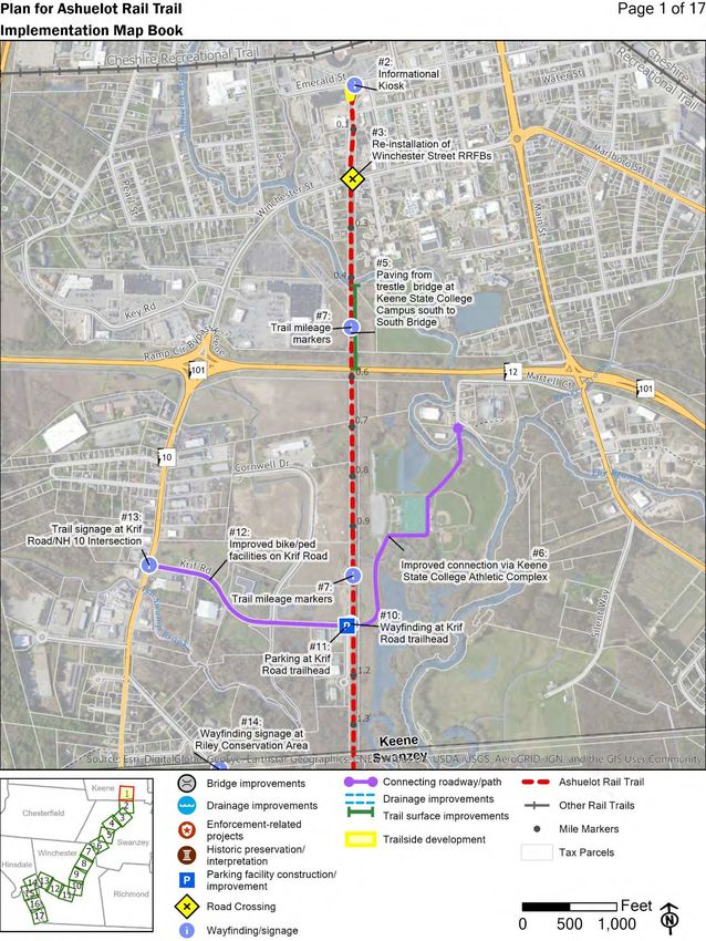
1

Disclaimer
The preparation of this document has been financed in part through grant[s] from
the Federal Highway Administration and Federal Transit Administration, U.S.
Department of Transportation, under the State Planning and Research Program,
Section of Title 23, U.S. Code. The contents of this report do not necessarily
reflect the official views or policies of the U.S. Department of Transportation.

Photos by Southwest Region Planning Commission

                   www.swrpc.org/plan-for-ashuelot-rail-trail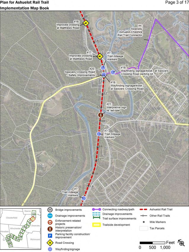
2
Acknowledgements
Plan for Ashuelot Rail Trail represents a team effort. Building a shared vision for
the trail’s future requires the participation of many individuals and organizations,
including:
Over 550 individuals participated in the project’s online survey, provided
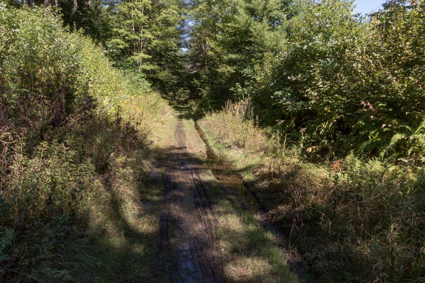
comments on the draft plan and shared feedback at various in-person
meetings and events.
A Project Advisory Committee (PAC), which provides guidance to SWRPC
staff over the course of the project at in-person “working meetings.” The
PAC included members from a spectrum of stakeholder groups, including
local government, state agencies, the business community, institutions of
higher education, the public health sector, conservation organizations, and
others.
o Bruce Bohannon, Town of Swanzey
o Sarah Bomba, Pisgah Mountain Trail Riders
o Rick Brackett, Monadnock Conservancy
o Chris Brehme, Keene State College
o Mari Brunner, City of Keene
o Drew Bryenton, Monadnock Cycling Club
o Jim Duffy, Pathways for Keene
o Christopher Gamache, Bureau of Trails
o Beth Giannini, Franklin Regional Council of Governments
o Christine Hadlow, Greater Keene Chamber of Commerce
o Mike Kowalczyk, Town of Swanzey
o Marion Major, Windham Regional Commission
o Chuck Redfern, NH Rail Trails Coalition
o Alan Rumrill, Historical Society of Cheshire County
o Rowland Russell, Antioch University New England
o Will Schoefmann, City of Keene
o Margaret Sharra, Town of Winchester
o Barbara Skuly, Ashuelot Local River Advisory Committee
www.swrpc.org/plan-for-ashuelot-rail-trail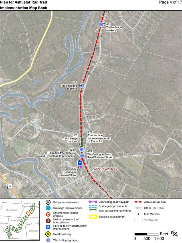
3
o Laura Susmann, Monadnock Happy Trails
o Tricia Zahn, Cheshire Medical Center
Many others that provided time and feedback at the project open house,
in-person/telephone interviews and at the PAC meetings.
www.swrpc.org/plan-for-ashuelot-rail-trail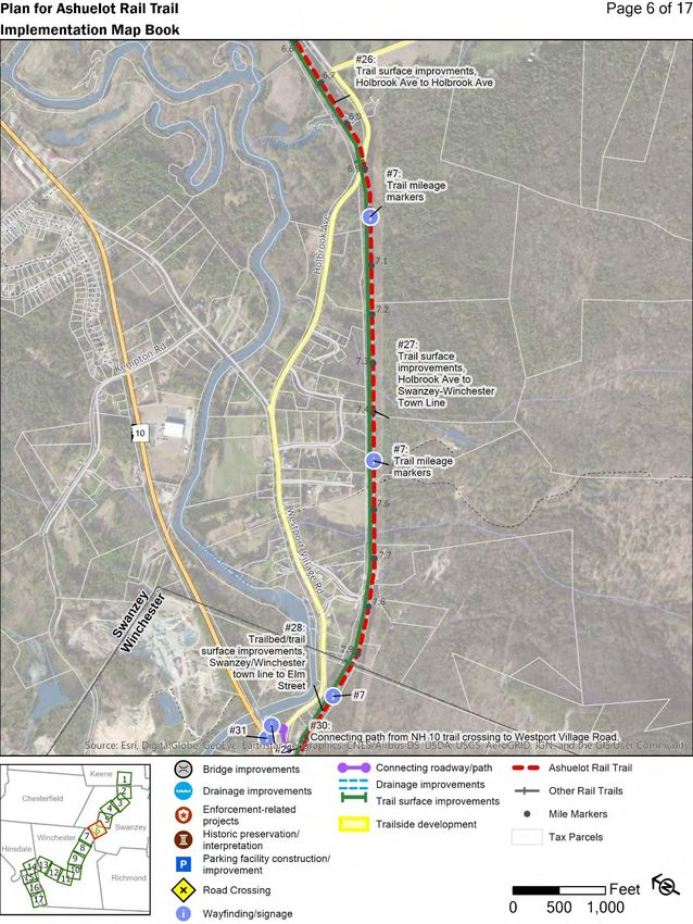
4

Table of Contents
Project Overview ............................................................................................... 6
Vision, Goals and Objectives ............................................................................. 8
Implementation Plan ........................................................................................ 13
Performance Measures ................................................................................... 51
Maintenance .................................................................................................... 56
Funding Resources ......................................................................................... 58
Design Resources ........................................................................................... 66
Appendix A: Existing Conditions Assessment Memos
    Current and Previous Plans/Literature Review
    Rail Trail Base Mapping/Inventory
    Bicycle/Pedestrian Collisions
    Bicycle/Pedestrian Counts
    Condition Assessment
    Programs and Health Analysis
    Economic Benefits
    Policy Integration

Appendix B: Public Outreach Memos
    Online Resident Survey
    User Group Survey
    Municipal Survey
    Key Stakeholder Interviews
    Intercept Surveys
    Open House

Appendix C: Project Advisory Committee Meeting Agendas & Minutes

                           www.swrpc.org/plan-for-ashuelot-rail-trail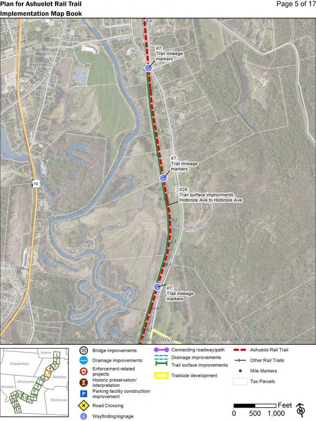
5

List of Tables
Table 1 - Plan for Ashuelot Rail Trail Project Tasks and Approximate Schedule 7
Table 2 - Implementation Plan Matrix .............................................................. 15
Table 3 – Implementation Plan Project Categories ........................................... 31
Table 4 – Implementation Plan Field Names and Descriptions ......................... 33
Table 5 - List of Performance Measures .......................................................... 52
Table 6 – Typical Trail Maintenance Budget ..................................................... 57
Table 7 – National Resources .......................................................................... 66
Table 8 - Accessibility Resources .................................................................... 67
Table 9 - Snowmobile-specific Resources ....................................................... 68
Table 10 - Equestrian-specific Resources ....................................................... 68
Table 11 - New Hampshire Resources ............................................................ 68
Table 12 - Other Resources............................................................................. 69

                         www.swrpc.org/plan-for-ashuelot-rail-trail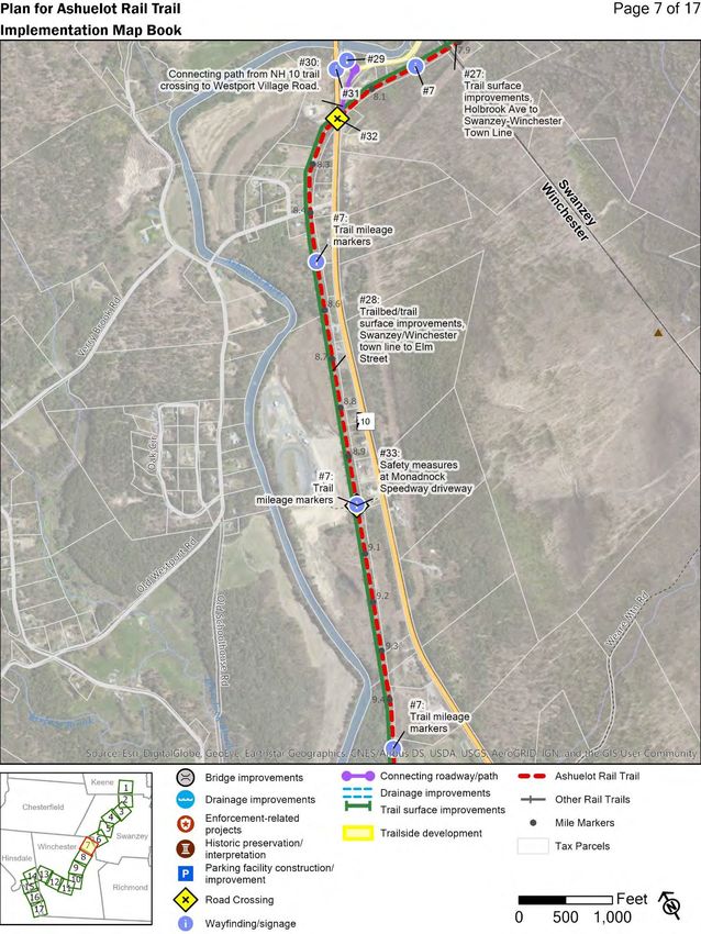
6

Project Overview
Plan for Ashuelot Rail Trail is a planning effort aimed at addressing challenges
and opportunities along the approximately 21.5-mile stretch of rail trail between
Keene and Hinsdale, New Hampshire. The former rail line was opened in 1851
and abandoned in 1983. Following abandonment, the corridor was purchased by
the State of New Hampshire through a 1994 funding round of the Federal Highway
Administration’s Transportation Enhancement Program1.

Although the New Hampshire Division of Parks and Recreation is the de facto
managing entity of the Trail, there are a number of entities that have an interest
or direct hand in the management of the Trail including other state agencies, local
governments and volunteer groups. Taking into account the multiple users and
interested parties, the Plan for Ashuelot Rail Trail is an effort to promote a
collaborative approach to managing and improving the Trail over time. The Plan
for Ashuelot Rail Trail documents a shared understanding of the condition of the
Trail today as well as a common vision for how the Trail could reach its full
potential in the future. With support from a wide spectrum of the Trail’s
stakeholders, goals, objectives and implementation strategies were developed to
guide collaborative efforts over the next ten years.

Development of the Plan for Ashuelot Rail Trail included various tasks conducted
between May of 2018 through December of 2019, outlined in detail on the
following page (Table 1).

To learn more about the results of various activities not included in the body of
the Plan, please consult Appendix A for the results of the Existing Conditions
Assessment and Appendix B for the results of Public Outreach activities.

1New Hampshire Department of Transportation, “New Hampshire State Trails Plan,” May 20, 2005,
https://www.nh.gov/dot/programs/bikeped/documents/StateTrailsPlanFullReport.pdf.

                         www.swrpc.org/plan-for-ashuelot-rail-trail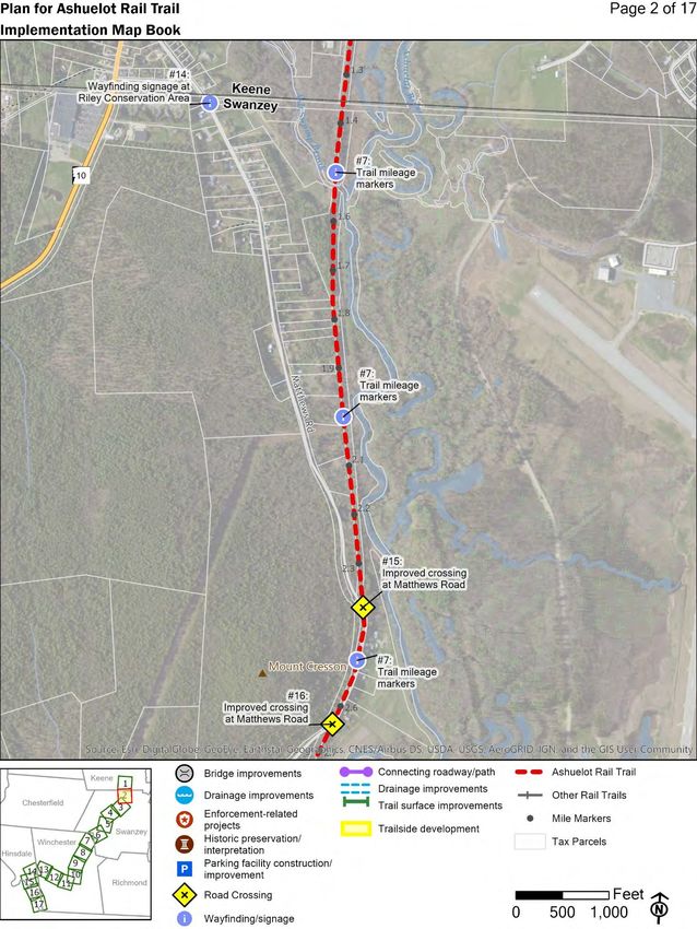
7

Table 1 - Plan for Ashuelot Rail Trail Project Tasks and Approximate Schedule
    Task       Activity        Results Shared with PAC

                                         2018                          2019
                                 M J J A S O N D J F M A M J J A S O N D
    Project Meetings &
    Coordination
    Project Advisory Committee
    Meetings
    Existing Conditions
    Assessment
    Literature Review
    Base Mapping/Inventory
    Bicycle/Pedestrian
    Collisions
    Bicycle/Pedestrian Counts
    Condition Assessment
    Programs Analysis
    Economic Benefit Analysis
    Policy Integration
    Public Outreach
    Online Resident Surveys
    Municipal Surveys
    User Group Surveys
    Intercept Surveys
    Open House
    Website and Media
    Needs Analysis
    Vision, Goals, and
    Objectives
    Design Guidelines
    Maintenance and Funding
    Performance Measures
    Implementation Plan
    Plan Development
    Draft Plan
    Final Plan

                          www.swrpc.org/plan-for-ashuelot-rail-trail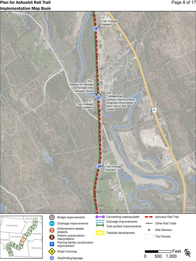
8

Vision, Goals and Objectives
A vision statement is a concise articulation of an ideal future. It establishes and
communicates the target end state that guides planning activities. Informed by
public engagement and data collection efforts undertaken for the Plan for
Ashuelot Rail Trail project, the following vision statement was developed with the
PAC. A total of six goals and twenty-seven objectives designed to move toward
the realization of this vision are found below. Method of measuring progress
towards these goals can be found in the section entitled “Performance Measures”
on page 51.

                          Vision for the Ashuelot Rail Trail
    The Ashuelot Rail Trail will function as a continuous transportation and
    recreation corridor that is well-maintained, scenic, convenient, easy to use,
    accessible, safe, and welcoming for all users. Trail facilities will balance the
    needs and priorities of the trail’s many stakeholders, including state agencies,
    municipalities, landowners, user groups, businesses, and non-profit
    organizations, who will work collaboratively to maintain and develop the trail as
    a shared public asset. The Trail will be widely celebrated as a valuable resource
    that enhances the surrounding area’s quality of life, ecology, history, and
    economic vitality.

Goal 1:       Increase awareness of the trail, among both local residents and
              visitors.

Objective 1:          Develop and distribute promotional materials, including
                      printed trail maps and brochures. Digital resources, such as
                      a website, app, or social media presence, should also be
                      considered.

Objective 2:          Establish a consistent trail brand rooted in the history and
                      unique characteristics of the surrounding communities and the
                      State’s trail network. A trail brand could include elements
                      such as a logo, standardized colors, graphics, and other

                      www.swrpc.org/plan-for-ashuelot-rail-trail
9
design features that could be used on signage, maps or other
promotional materials.
Objective 3: Design and implement a year-round wayfinding system
standardized along the Trail’s entire route. Such a system
could use a combination of signs and maps, located both on
the trail and at nearby points of interest, e.g. village centers.
Objective 4: Design and install signage that advertises the Trail to
motorists passing by trail crossings.
Objective 5: Integrate the trail with community and school activities, events
and curriculum.
Objective 6: Coordinate mapping activities, updates, and promotion with
relevant State partners, the private sector (such as Google
Maps), and others.
Objective 7: Take advantage of the State Board of Tourism’s marketing
program and other resources to promote the Trail.
Goal 2: Increase use of the trail as an alternative for trips made by car.
Objective 1: Integrate the Trail with the surrounding roadway network, with
a focus on improving connections between the Trail and key
points of interest, like village centers, schools, and residential
neighborhoods.
Objective 2: Develop and maintain a trail surface easily traversed using a
variety of transportation modes and by people of all ages and
abilities.
www.swrpc.org/plan-for-ashuelot-rail-trail10
Goal 3: Expand opportunities for physical activity and outdoor experiences.
Objective 1: Improve connections between the rail trail and nearby parks,
trails (including the Fort Hill Branch and Cheshire Rail Trail)
and natural areas.
Objective 2: Establish access points from the rail trail to the Ashuelot River.
Objective 3: Promote the Trail as part of both individual health, wellness as
well as overall community health improvement initiatives.
Objective 4: Protect sensitive habitats and natural resources along the trail
corridor.
Goal 4: Enhance regional and local economies.
Objective 1: Promote the Trail as a tourism destination.
Objective 2: Work with employers to promote the trail as an employee
recruitment and retention benefit.
Objective 3: Work with relevant groups/organizations to organize and
advertise on-trail events.
Objective 4: Promote context-sensitive land uses that complement the
Trail. Nearby existing development, complementary land
uses might include retail establishments, tourism-based
industries, restaurants, or residential neighborhoods. In more
rural areas, open space and agricultural land uses may be
most appropriate.
www.swrpc.org/plan-for-ashuelot-rail-trail11
Goal 5: Create an on-trail experience that is accessible, safe and welcoming
for all ages, abilities and user groups.
Objective 1: Enhance safety at trail/road crossings.
Objective 2: Educate trail users regarding trail etiquette and regulations
through posted signs and other outreach methods.
Objective 3: Clearly delineate the public trail right-of-way from abutting
privately-owned parcels.
Objective 4: Identify areas where on-trail encroachment poses an issue
and work with landowners to address encroachment of private
property onto public land.
Objective 5: Consider installation of lighting at trail crossings and other
locations where appropriate.
Objective 6: Maintain a clean trail environment through a trail adoption
program, routine maintenance, trash/recycling receptacles,
and by establishing user expectations.
Objective 7: Ensure that trailheads offer parking areas that accommodate
a variety of users and vehicles (including bicycles, vans,
buses, trailers).
Objective 8: Ensure safety of trail users through enforcement activities by
local and State agencies.
Objective 9: Address encroachments onto rail trail properties and other
issues.
www.swrpc.org/plan-for-ashuelot-rail-trail12
Goal 6: Facilitate communication and collaboration among trail stakeholders.
Objective 1: Establish an umbrella “friends of the trail” organization with
members from a wide variety of stakeholder groups. Such an
umbrella organization could function as an entity through
which to coordinate trail maintenance, trail development
projects, marketing, advocacy, fundraising, and more.
Objective 2: Strengthen the connections between snowmobile clubs and
non-motorized wintertime users that benefit from winter
maintenance.
www.swrpc.org/plan-for-ashuelot-rail-trail13
Implementation Plan
The planning process to develop Plan for Ashuelot Rail Trail included a wide
variety of data gathering and public engagement activities, all of which provided
useful information about the existing conditions of the Trail, how the Trail is used
and managed today and how stakeholders would like to see the Trail improved in
the future.
The purpose of the implementation plan is to translate the vision, goals and
objectives into specific recommended projects on the ground. The
implementation plan also seeks to incorporate stakeholder and PAC feedback
about particular improvements that they would like to see made on the Trail or
connecting roads and pathways.
Table 2, Implementation Plan Matrix (pp.15-30) provides a summary description
of 71 individual projects along the Trail that were identified as part of this rail trail
planning effort. The matrix is accompanied by a map book showing the location
of potential projects that could be mapped.
Table 3, Implementation Plan Project Categories (pp. 31-32) identifies and
describes project categories. Table 4, Implementation Plan Field Names and
Descriptions (p. 33) identifies field names and other descriptive information to
facilitate use of the map book.
Projects included in the implementation plan are currently listed without a priority
ranking. Implementation of listed projects will require trail stakeholders to
prioritize projects according to perceived need and available resources.
Developing and undertaking a prioritization process, therefore, would be a
beneficial next step towards plan implementation. Project prioritization could
occur under the auspices of a friends of the trail group, with the whole trail taken
under consideration. Particular trail-related groups could also prioritize projects
within their geographic area of concern.
www.swrpc.org/plan-for-ashuelot-rail-trail14
Implementation projects, regardless of the funding mechanism, will
require coordination with trail owners and managers – New Hampshire
Bureau of Trails, New Hampshire Department of Transportation and the
City of Keene.
www.swrpc.org/plan-for-ashuelot-rail-trail15
Table 2 - Implementation Plan Matrix
ID Name Description Municipality Category Page
1 Pocket park and South of Emerald Street, the City of Keene owns a Keene Amenity 1
amenities at Emerald small parcel adjacent the abandoned railroad construction/improvement
Street corridor right-of-way. Located at the intersection of
the Ashuelot Rail Trail and the Cheshire Rail Trail,
the parcel represents an opportunity to develop a
pocket park at the center of its rail trail network.
Currently, a portion of the parcel is occupied by
paved parking leased to an adjacent landowner.
2 Informational Kiosk The Cheshire Rail Trail and Ashuelot Rail Trail Keene Wayfinding/signage 1
intersect at Emerald Street, west of Ralston Street.
The intersection serves as the center point for the
region's rail trail system. An informational kiosk with
wayfinding information such as maps would help
residents and visitors to navigate along both rail
trails.
3 Re-installation of Rectangular rapid flashing beacons (RRFBs) were Keene Road Crossing 1
Winchester Street previously installed at the Winchester Street
RRFBs crossing were damaged during previous roadway
work. The beacons are planned to be replaced
sometime in 2019-2020.
4 Swanzey Ashuelot- Currently, both rail trails in Swanzey run north- Swanzey Connecting roadway/path 3
Cheshire Rail Trail south, with no off-highway route connecting the two.
Connector A proposed route along Marcy Hill Road (a class VI
road) and across Keene Dillant-Hopkins Airport land
has been under discussion for some time (depicted
route is a gross approximation). If the route were
constructed, it would establish an approximately 8-
mile loop that runs through the center of Keene.
www.swrpc.org/plan-for-ashuelot-rail-trail16
ID Name Description Municipality Category Page
5 Paving from The high-traffic segment from the trestle bridge over Keene Trail surface 1
trestle bridge at the Ashuelot River on the Keene State College improvements
Keene State College campus to South Bridge over NH 101 is the only
Campus south to segment of the Ashuelot Rail Trail that has thus far
South Bridge been considered for paving.
6 Improved connection The driveway to and pathways within the Keene Keene Connecting roadway/path 1
via Keene State State College Athletic Complex provide a
College Athletic connection from the Ashuelot Rail Trail to Martell
Complex Court and NH 12. The connection could be
strengthened by adding pedestrian and/or cyclist
facilities (like shared lane markings, advisory
shoulder or advisory signage) along the driveway.
7 Trail mileage markers Trail mileage markers would help visually establish All Wayfinding/signage 1-16
the Rail Trail's route, even where the trailbed/trail
surface are in rustic condition. Mileage markers
would also help first responders to locate any
injured/distressed trail users that have called for
emergency services. If mileage markers were
placed every half mile, a total of 43 markers would
be required to cover the entire trail. Frequency of
mile marker could be modified to adjust for available
funds and available volunteer labor.
8 Historic railroad mile Locating and restoring railroad mile markers (often All Historic N/A
markers granite posts) would add to the trail’s historic preservation/interpretation
attributes.
9 Restore stone box Locating and restoring original stone box culverts All Historic N/A
culverts would ensure adequate drainage and preserve preservation/interpretation
historic features.
www.swrpc.org/plan-for-ashuelot-rail-trail17
ID Name Description Municipality Category Page
10 Wayfinding at Krif Krif Road currently functions as an informal Keene Wayfinding/signage 1
Road trailhead trailhead. Along with the driveway to the Keene
State College Athletic Complex, it forms an
intersection with the Ashuelot Rail Trail. An
informational kiosk could provide trail users a way to
navigate to key points of interest to the north, near
downtown Keene, to the west, along NH 10, to the
east, along NH 12, or south, along the Rail Trail.
The area is also the junction between the State’s
Corridor Trail System (4) and Primary Trail System
(400).
11 Parking at Krif Road An informal parking area is located at the Krif Road Keene Parking facility 1
trailhead trailhead in the remnant of a former cul de sac. construction/improvement
Although there currently isn't space within the public
right-of-way to pave additional parking, the width of
the roadway could accommodate on-street parking
if restriped accordingly. The area is also the
junction between the State’s Corridor Trail System
(4) and Primary Trail System (400). Partnering with
the adjacent landowners (including Eversource)
may result in a larger parking area that could
accommodate snowmobile trailers.
12 Improved Krif Road is approximately 40 feet wide, offering Keene Connecting roadway/path 1
bicycle/pedestrian ample space to improve pedestrian and cyclist
facilities on Krif Road facilities within the public right-of-way. With
pedestrian/cyclist improvements planned for NH 10,
Krif Road is well positioned to function as a critical
link to that busy commercial corridor. At minimum,
striped shoulders could be widened. Bicycle lanes
and curbed sidewalks would further strengthen the
connection.
www.swrpc.org/plan-for-ashuelot-rail-trail18
ID Name Description Municipality Category Page
13 Trail signage at Krif Wayfinding signage at the Krif Road/NH 10 Keene Wayfinding/signage 1
Road/NH 10 Intersection would help motorists navigate to the
Intersection informal trailhead to the east on Krif Road.
14 Wayfinding signage Riley Conservation Area hosts one of the best Swanzey Wayfinding/signage 1-2
at Riley Conservation parking facilities with direct access to the Ashuelot
Area Rail Trail. From the driveway on Matthews Road,
however, it is not apparent that the Trail is
accessible from the area. New signage on
Matthews Road near the driveway would improve
Trail wayfinding and visibility.
15 Improved crossing at Matthews Road weaves back and forth across the Swanzey Road Crossing 2
Matthews Road Ashuelot Rail Trail, intersecting three times over the
(northernmost course of about a half-mile. Intersections occur at
location) sharp angles, with poor sightlines as drivers
approach the crossing. Pedestrian warning signs
are present in advance of all three intersections, but
additional steps could improve safety (such as
lighting, high-visibility crosswalk markings, raised
crosswalk, and rectangular rapid flashing beacons).
16 Improved crossing at Matthews Road weaves back and forth across the Swanzey Road Crossing 2-3
Matthews Road Ashuelot Rail Trail, intersecting three times over the
(middle location) course of about a half-mile. Intersections occur at
sharp angles, with poor sightlines as drivers
approach the crossing. Pedestrian warning signs
are present in advance of all three intersections, but
additional steps could improve safety (such as
lighting, high-visibility crosswalk markings, raised
crosswalk, and rectangular rapid flashing beacons).
www.swrpc.org/plan-for-ashuelot-rail-trail19
ID Name Description Municipality Category Page
17 Improved crossing at Matthews Road weaves back and forth across the Swanzey Road Crossing 3
Matthews Road Ashuelot Rail Trail, intersecting three times over the
(southernmost course of about a half-mile. Intersections occur at
location) sharp angles, with poor sightlines as drivers
approach the crossing. Pedestrian warning signs
are present in advance of all three intersections, but
additional steps could improve safety (such as
lighting, high-visibility crosswalk markings, raised
crosswalk, and rectangular rapid flashing beacons).
18 Wayfinding The public parking lot on Sawyers Crossing Road is Swanzey Wayfinding/signage 3
signage/kiosk at located within close proximity (250 feet) to the
Sawyers Crossing Ashuelot Rail Trail, but the trail crossing is not
Road parking lot clearly visible from the lot. Wayfinding signage or a
kiosk would raise Trail awareness and clearly direct
visitors how to find the trail. The lot should also be
signed to alert motorists that the parking lot serves
as a trailhead to the Ashuelot Rail Trail.
19 Wayfinding The Sawyers Crossing Road trail crossing is located Swanzey Wayfinding/signage 3
signage/kiosk at within 600 feet of Cresson Bridge, one of the Town's
Sawyers Crossing historic covered bridges. Trail users can turn onto
Road Sawyer's Crossing Road and travel a 12-mile loop
that visits each of the covered bridges. An existing
map is installed in the parking lot off of Sawyers
Crossing Road, but neither the trail crossing nor the
covered bridge are visible from the trail crossing.
Installation of wayfinding signage at the trail
crossing could raise awareness of the nearby
covered bridge and the covered bridge recreational
loop.
www.swrpc.org/plan-for-ashuelot-rail-trail20
ID Name Description Municipality Category Page
20 Sawyers Crossing The Sawyers Crossing Road is a relatively busy trail Swanzey Road Crossing 3
Road - Safety crossing (averaging almost 3,700 vehicles per day)
Improvements that currently lacks any safety measures. Trail
warning signs and lights are among possible
measures that should be considered.
21 Interpretive sign re: An artifact from the railroad era predating the Swanzey Historic 3
tell-tale advent of pneumatic brakes, a “tell-tale” still stands preservation/interpretation
next to and above the rail trail. Tell-tales were
constructed to warn brakemen, who had to engage
mechanical brakes from atop each train car, that
obstacles lay ahead.
22 Trail surface This approximately 750-foot trail segment is Swanzey Trail surface 4
improvement north of targeted for improvement through the Town of improvements
Eaton Rd. Swanzey's successful 2018 Transportation
Alternatives Program grant application. The trailbed
is currently sandy and subject to severe erosion.
Planned improvements include stabilization of the
trailbed and upgrading the trail surface to a 10-foot
wide layer of stone dust.
23 Wayfinding at Eaton The trail intersection at Eaton Road/Railroad Street Swanzey Wayfinding/signage 4
Road/Railroad Street is a critical trail junction, where trail users can turn
and travel towards the village of West Swanzey,
where civic institutions, businesses and a park is
located. The Ashuelot River Campground is also
located nearby. Currently, however, there is no
signage that alerts trail users to nearby points of
interest, except for an undescriptive road sign that
indicates the nearby presence of a campground.
Improved wayfinding at this intersection could help
the village of West Swanzey leverage the trail as an
economic development asset.
www.swrpc.org/plan-for-ashuelot-rail-trail21
ID Name Description Municipality Category Page
24 Railroad Street Currently, there's an approximately 440 foot gap Swanzey Connecting roadway/path 4
Bicycle and between the Ashuelot Rail Trail and existing
Pedestrian sidewalk on Railroad Street. Installation of
Improvments pedestrian facilities along this gap - either sidewalk
or a painted advisory shoulder - would connect the
Rail Trail with the sidewalk network that runs
throughout the village of West Swanzey.
25 Parking on Railroad A paved, unused lot could be converted into Swanzey Parking facility 4
Street trailhead parking. Access to the lot is currently construction/improvement
blocked by a cordon of stones. The existing lot is
approximately 7,500 square feet. The property
owner is Eversource.
26 Trail surface This 7,357-foot (1.39-mile) trail segment is also Swanzey Trail surface 5-6
improvments, targeted for improvements through the Town of improvements
Holbrook Ave to Swanzey's successful 2018 Transportation
Holbrook Ave Alternatives Program proposal. The trailbed will be
stabilized and the trail surface upgraded to stone
dust.
27 Trail surface This 5,495-foot (1.04-mile) trail segment is targeted Swanzey Trail surface 6-7
improvements, for improvements through the Town's 2018 improvements
Holbrook Ave to Transportation Alternatives Program proposal. The
Swanzey-Winchester trailbed will be stabilized and the trail surface
Town Line upgraded to packed stone dust.
www.swrpc.org/plan-for-ashuelot-rail-trail22
ID Name Description Municipality Category Page
28 Trailbed/trail surface The approximately 5.25-mile section of trail from the Winchester Trail surface 6-10
improvements, Swanzey-Winchester town line to Elm Street in improvements
Swanzey/Winchester downtown Winchester includes some of the Rail
town line to Elm Trail's roughest terrain. The existing trail surface is
Street unimproved and is predominately composed of a
mixture of dirt, gravel and sand. Portions of the trail
are overgrown with vegetation. If trailbed stability
were improved and the trail surface were upgraded
to packed stone dust in a fashion similar to that of
improved trail segments in Swanzey, connectivity
along the entire Rail Trail corridor would be greatly
enhanced.
29 Wayfinding at The existing parking lot on Westport Village Road Winchester Wayfinding/signage 6-7
Westport Village has potential to serve as a trailhead parking facility.
Road parking lot The trail, however, is located just out of sight.
Wayfinding signage or maps could help inform trail
users how/where to access the trail.
30 Connecting path from The trail crossing at NH 10 is located within 500 feet Winchester Connecting roadway/path 6-7
NH 10 trail crossing to of an existing parking lot and river access point on
Westport Village Westport Village Road. An informal path shows
Road. evidence of trail user traffic between the trail and
the parking lot. An officially established pathway
with a dirt or stone dust surface would enhance the
connection between the trail and the parking lot. It
would also grant trail users access to the Ashuelot
River. Currently, river access points along the trail
are somewhat limited. The proposed pathway
would need not cross any privately owned parcels,
either remaining in the public right of way or
crossing a small NHDOT-owned parcel on the SE
corner of NH 10 and Westport Village Road.
www.swrpc.org/plan-for-ashuelot-rail-trail23
ID Name Description Municipality Category Page
31 Trail parking sign at An existing parking lot on Westport Village Road Winchester Wayfinding/signage 6-7
NH10 and Westport has the potential to serve as a parking facility for
Village Road trail users. Many motorists, however, especially
tourists, may not be aware of the trail's presence.
Parking and trail signs on NH 10, both north and
south of Westport Village Road, would enhance trail
visibility.
32 NH 10 Crossing The crossing at NH 10 represents a major barrier to Winchester Road Crossing 7
trail users. High speed traffic (50 MPH posted
speed limit) poses a serious safety concern. The
trail crossing warrants an assessment of potential
safety improvements. At minimum, trail warning
signs could alert motorists to the presence of a trail
crossing. High-visibility crosswalk markings,
lighting and rectangular rapid flashing beacons are
other measures to consider.
33 Safety measures at The Ashuelot Rail Trail crosses the driveway of the Winchester Road Crossing 7
Monadnock Monadnock Speedway, which can attract large
Speedway driveway volumes of spectators during events. The driveway
should be evaluated for potential safety
improvements.
34 Repairs to railroad Bridge decking and railings require Winchester Bridge improvements 8
bridge over Ashuelot maintenance/replacement.
River
35 Culvert installation Erosion currently undermines trailbed integrity. A Winchester Drainage improvements 9
culvert or other drainage measure should be
considered for installation.
36 Culvert replacement A collapsed culvert currently causes slumping in Winchester Drainage improvements 10
thetrailbed. The culvert should be evaluated for an
appropriate replacement
www.swrpc.org/plan-for-ashuelot-rail-trail24
ID Name Description Municipality Category Page
37 Drainage An especially-soggy 100-200 foot trail segment may Winchester Drainage improvements 10
improvements benefit from improved drainage ditches. Any
trailbed work should include consideration of viable
drainage improvements.
38 Culvert improvement A culvert constructed out of a 6-8" diameter PVC Winchester Drainage improvements 10
pipe is currently protruding about 4" above the trail
surface. The culvert should be considered for
improvement or replacement in conjunction with any
planned trailbed/trail surface improvements.
39 Bridge improvement The former A. C. Lawrence Tannery property is Winchester Connecting roadway/path 10
and trail access point adjacent to the rail trail and the Ashuelot River and
was connected to NH 10 via a highway bridge that
is currently closed. The crossing represents an
opportunity to provide additional access to the trail
as well as a short loop close to downtown. The
property is a notable historic asset.
40 Improve bicycle and Elm Street provides a critical connection from the Winchester Connecting roadway/path 10
pedestrian facilities Ashuelot Rail Trail to downtown Winchester.
on Elm Street Currently, an asphalt sidewalk runs along the south
side of Elm Street, but a small gap exists where no
sidewalk is present. Bicycle facilities are absent
from the trail. A bike lane or sharrows could
enhance bicycle connectivity between the trail and
downtown establishments.
41 Gate repair north of The gate north of Elm Street has been Winchester Enforcement-related 10
Elm Street compromised, allowing ATVs to circumvent it. The projects
installation of extra posts/bollards could help
improve gate effectiveness.
www.swrpc.org/plan-for-ashuelot-rail-trail25
ID Name Description Municipality Category Page
42 Wayfinding at Elm The trail crossing at Elm Street is a critical trail Winchester Wayfinding/signage 10
Street junction, located within 700 feet of Winchester's
downtown village. Currently, no signage exists
indicating to trail users that business are located
nearby. Installation of wayfinding signage could
help encourage trail users to patronize downtown
businesses.
43 Trailbed/trail surface The trail bed and surface on the 4.75-mile segment Winchester Trail surface 10-
improvements, Elm from Elm Street in downtown Winchester to the improvements 14
St. to Winchester/Hinsdale town line are predominately
Winchester/Hinsdale unimproved and should be evaluated for potential
TL reconstruction and surface improvements with
packed stone dust.
44 Safety improvement This high speed, unmarked road crossing at NH 119 Winchester Road Crossing 10-
at NH 119 Road should be evaluated for potential safety 11
Crossing improvements, including trail warning signs.
45 Railroad bridge over Bridge decking and railings require Winchester Bridge improvements 11
Ashuelot River, maintenance/replacement.
Ashuelot village
46 Drainage ditching This especially wet segment of trail may warrant Winchester Drainage improvements 11
drainage ditch work.
47 Removal/replacement An informal wooden boardwalk constructed out of Winchester Drainage improvements 11
of informal boardwalk saplings currently detracts from trail surface quality.
The boardwalk should be considered for removal in
conjunction with drainage ditching.
48 Culvert improvement A culvert constructed out of a combination of black Winchester Drainage improvements 11
or enhancement plastic pipe and galvanized metal is currently
exposed above the trail surface. The culvert should
be considered for replacement.
49 Improved drainage An especially wet segment of trail should be Winchester Drainage improvements 11
ditches considered for drainage ditch work
www.swrpc.org/plan-for-ashuelot-rail-trail26
ID Name Description Municipality Category Page
50 Historic marker at The Ashuelot Village covered bridge and the former Winchester Historic 12
Ashuelot Village train depot are both distinctive historic landmarks preservation/interpretation
covered bridge and that contribute to the unique character of the village.
former depot Trail users have clear sightlines to both landmarks.
51 Improve connection A Pisgah State Park trailhead/parking lot is located Winchester Connecting roadway/path 13
between Recycle within walking distance (1/3 mile) of the Rail Trail
Way and Pisgah intersection with Recycle Way. The connecting
State Park segment of NH 119, however, has narrow shoulders
and lacks bicyclist/pedestrian facilities.
52 Culvert A culvert constructed out of metal pipe is currently Winchester Drainage improvements 12
enhancements exposed approx. 4-6" above the trail surface.
Consideration should be given whether to reinstall
the culvert below grade or raise the trailbed to cover
the culvert.
53 Culvert A culvert constructed out of black plastic drainage Winchester Drainage improvements 12
enhancements pipe is currently exposed above the trail surface.
Consideration should be given whether to reinstall
the culvert at a lower level or to raise the trail
surface so that the culvert lies below grade.
54 Drainage ditching Waterlogged trail conditions call for consideration of Winchester Drainage improvements 12
drainage ditch work
55 Assessment and Derelict trailside structures create an environment Winchester Redevelopment 13
cleanup at the former that likely feels uninviting and unsafe to many trail opportunity
Ashuelot Paper Co. users. Environmental contaminants are likely
Property present onsite. The property should be considered
for future EPA Brownfields assessment and cleanup
work.
56 Trailbed/trail surface The 3.6-mile segment of the rail trail that runs Hinsdale Trail surface 13-
improvements, through Hinsdale is predominately unimproved and improvements 16
Winchester/Hinsdale in many places waterlogged. If the trailbed was
TL to Dole Junction reconstructed and the trail surface improved with
Parking Lot packed stone dust, the trail would be accessible to a
wider array of users.
www.swrpc.org/plan-for-ashuelot-rail-trail27
ID Name Description Municipality Category Page
57 Culvert replacement A culvert constructed out of black plastic drainage Winchester Drainage improvements 12
pipe currently sits approx. 4" above the trail surface.
The top of the pipe is in a state of deterioration. The
culvert should be considered for replacement. Any
replacement culvert should be sunk completely
below grade.
58 Assessment and A derelict trailside mill structure detracts from the Winchester Redevelopment 13-
cleanup at the former otherwise scenic quality of the trail and creates an opportunity 14
American Tissue Mills environment that many trail users would likely
property consider unsafe. The property should be considered
for EPA Brownfields assessment and cleanup work.
59 Depot Street Depot Street forms a critical link between the Hinsdale Connecting roadway/path 14-
Bicycle/Pedestrian Ashuelot Rail Trail and downtown Hinsdale. 15
Improvements Currently, a sidewalk is present on one side of the
street from NH 119/Main Street running south to
Glen Street. An approximately 500-foot gap,
however, still exists where no sidewalk is present.
No cycling facilities are present along the entire
road segment. Improved pedestrian and bicyclist
infrastructure could improve safety for trail users
walking/cycling from the downtown village and
would encourage trail use by individuals of a variety
of ages and abilities.
60 Trail warning signs at No trail warning signs are currently present on Hinsdale Road Crossing 14-
Depot Street Depot Street, either north or south of the 15
intersection with the Ashuelot Rail Trail. Trail
warning signs would help improve trail crossing
safety and, if combined with a sign displaying the
trail name, would function as a device for increasing
trail awareness.
www.swrpc.org/plan-for-ashuelot-rail-trail28
ID Name Description Municipality Category Page
61 Wayfinding at Depot For westbound users, it is unclear whether or where Hinsdale Wayfinding/signage 14-
Street the trail continues beyond Depot Street. The trail 15
section that continues on to Dole Junction can be
accessed via a driveway to a private home (the
renovated historic Hinsdale Depot), but it is
unknown whether the driveway is located in the
public right-of-way. If members of the public are in
fact permitted to use the driveway to access the
trail, then wayfinding signage or trail markers are
warranted.
62 Historic marker at The historic Hinsdale Depot, today renovated as a Hinsdale Historic 14
Hinsdale Depot private home, is a unique trailside relic that testifies preservation/interpretation
to the trail's history as a railroad corridor. A historic
marker or interpretive sign would help educate trail
users about the trail's history.
63 Gate installation Currently, no gates are present north or south of Hinsdale Enforcement-related 14-
Tower Hill Road Tower Hill Road, allowing unauthorized ATVs to projects 15
crossing access the trail. Gate installation using plan-
recommended design guidelines should be
considered.
64 NH 63 Crossing at A Citgo station used as a refueling station by Hinsdale Road Crossing 15
Citgo Station snowmobilers is located in close proximity to the
Rail Trail, across NH 63, which can be accessed
from the trail via a segment of a private driveway
with the rail trail corridor and the public right-of-way
The crossing is a candidate location for a trail
warning sign to alert motorists to the presence of a
crossing.
65 Increased Unauthorized ATV and trail bike use is a known Hinsdale Enforcement-related 15
surveillance and issue along multiple segments of the rail trail. projects
enforcement of Installation of a trail camera could enable trail
unauthorized access advocates to monitor and report ATV and trail bike
at southernmost gate traffic on the trail.
www.swrpc.org/plan-for-ashuelot-rail-trail29
ID Name Description Municipality Category Page
66 NH 63 Crossing at The entrance to the Dole Junction parking lot is Hinsdale Road Crossing 16
Dole Junction parking offset by about 150' from a trailhead across NH 63,
lot forcing users to access the trail via narrow roadway
shoulders. The crossing warrants evaluation for
potential safety improvements, including, but not
limited to widened shoulders or providing trail
access directly across the parking lot entrance. Trail
warning signs should also be considered both north
and south of the crossing.
67 Improved signage at Current signage for parking lot is not visible to Hinsdale Wayfinding/signage 16
Dole Junction approaching motorists. Currently oriented parallel to
trailhead parking lot the roadway. Replace/supplement with two signs -
one visible to northbound and one visible to
southbound motorists.
68 Trail planning and State-owned abandoned railroad corridor continues Hinsdale Trail surface 16-
clearing, Dole to run south of the Dole Junction parking lot, but the improvements 17
Junction Parking Lot 1.2-mile trail segment is overgrown and obstructed
to Ashuelot River to the point of being unusable. The section should
be assessed for potential rehabilitation.
69 Connecticut River Abutments and piers to a former railroad bridge can Hinsdale Bridge improvements 17
crossing be found north of the Hinsdale/Northfield, MA line.
The crossing presents an opportunity to connect a
series of bridges over the Connecticut River.
70 Retrofit gates to Most road crossings along the Ashuelot Rail Trail All Enforcement-related N/A
discourage ATV use have gates intended to limit access by motorized projects
vehicles. A stile is located next to each gate,
intended to grant access to the Trail when the gate
is closed. These stiles, created by placing a post
about 5-6 feet to the side of the gate, are often so
wide that they do not prevent ATVs from accessing
the trail. Stiles could be narrowed to discourage
ATV use while still allowing permitted users to freely
access the trail.
www.swrpc.org/plan-for-ashuelot-rail-trail30
ID Name Description Municipality Category Page
71 Installation of The installation of elevated camping platforms All Amenity N/A
camping platforms within the trail corridor or on adjacent parcels has construction/improvement
the potential to create an attractive family camping
experience.
www.swrpc.org/plan-for-ashuelot-rail-trail31
Table 3 – Implementation Plan Project Categories
Project Category Description
Trail amenities include things that make using the
trail easier and more enjoyable to a variety of
Amenities users. Examples of trail amenities include
benches, water fountains, bathrooms, or camping
facilities.
Bridge-related projects could involve the
Bridges renovation or replacement of existing trail
bridges.
Awareness and use of the trail hinges not only on
Connecting roadways and the quality of the trail itself, but also on how easily
paths trail users are able to access common origins and
destinations to/from the trail.
Projects related to environmental conservation
could entail the enhancement or preservation of
natural resources within the trail corridor
Environmental
(especially along developed segments),
conservation
installation of interpretive signage, preservation
of on-trail or trailside wildlife habitat, or other
activities.
Projects that enhance trail-related coordination
Coordination seek to improve communication among different
trail stakeholders.
Drainage-related projects could include the repair
Drainage or replacement of culverts, clearing drainage
ditches, or other water diversion projects.
Enforcement-related projects aim to foster a trail
environment that feels safe to all permitted users
and to minimize the amount of unauthorized trail
Enforcement
traffic. Examples of enforcement-related projects
could include activities such as the installation of
trail cameras or gate repairs/modifications.
www.swrpc.org/plan-for-ashuelot-rail-trail32
Project Category Description
Projects related to historic preservation could
include activities such as the installation of
Historic preservation interpretive signage or other measures to
highlight the unique history of the trail and
trailside communities.
Parking related projects could include the
creation or modification of parking facilities in
Parking
order to better accommodate vehicles and trailers
for permitted users.
Projects related to programming could include
specific on-trail events/programs or the
Programming development of mechanisms that make it easier
for individuals or groups to organize on-trail
events/programs.
Promotion or marketing related to projects
Promotion/marketing include those that raise general awareness of the
trail.
Trailbed and trail surface projects are those that
Trailbed/trail surface
aim to improve the physical condition of the trail.
The on-trail experience depends not only on the
quality of the trail itself, but also on the
characteristics of the surrounding environment.
Restoration projects could include cleanup or
Restoration/development
remediation of contaminated trailside projects.
Development projects might include new
development of housing, commercial space, or
other built assets at key trail locations.
Wayfinding and signage projects improve the
navigation along the trail and to/from nearby
Wayfinding and signage origins and destinations. Signage projects may
also aim to communicate other information to trail
users, such as standards of trail etiquette.
www.swrpc.org/plan-for-ashuelot-rail-trail33
In addition to a project category, an array of information accompanies each
project. Data fields for implementation plan projects are listed and described in
Table 4, below.
Table 4 – Implementation Plan Field Names and Descriptions
Field Name Description
A unique project identification number. Project ID
numbers are based on project location, running in
ID
ascending order from the Trail’s northern terminus in
Keene to its southern terminus in Hinsdale.
Name A brief descriptive project name
A more in depth project description that summarizes
Description
project need and potential improvements
The municipality in which the proposed project is
Municipality located. Some projects may be applicable to all
trailside municipalities.
The project category (see Table 3, above, for a list of
Category
categories)
The map booklet page(s) on which the project
Page
appears.
Some important information is not included in the fields listed above. For
example, project priority, timing and estimated costs are absent, falling outside
the scope of this current effort. These factors, however, should be considered
during the implementation process. Accordingly, project prioritization, project
scheduling and cost estimation are included as projects within the implementation
plan.
www.swrpc.org/plan-for-ashuelot-rail-trail34
www.swrpc.org/plan-for-ashuelot-rail-trail35
www.swrpc.org/plan-for-ashuelot-rail-trail36
www.swrpc.org/plan-for-ashuelot-rail-trail37
www.swrpc.org/plan-for-ashuelot-rail-trail38
www.swrpc.org/plan-for-ashuelot-rail-trail39
www.swrpc.org/plan-for-ashuelot-rail-trail40
www.swrpc.org/plan-for-ashuelot-rail-trail41
www.swrpc.org/plan-for-ashuelot-rail-trail42
www.swrpc.org/plan-for-ashuelot-rail-trail43
www.swrpc.org/plan-for-ashuelot-rail-trail44
www.swrpc.org/plan-for-ashuelot-rail-trail45
www.swrpc.org/plan-for-ashuelot-rail-trail46
www.swrpc.org/plan-for-ashuelot-rail-trail47
www.swrpc.org/plan-for-ashuelot-rail-trail48
www.swrpc.org/plan-for-ashuelot-rail-trail49
www.swrpc.org/plan-for-ashuelot-rail-trail50
www.swrpc.org/plan-for-ashuelot-rail-trail51
Performance Measures
Performance measures can be used to gauge the success towards the Plan’s goals and objectives. Table 5, List of
Performance Measures suggests a variety of ways progress could be tracked and measured. However, more work is
needed to identify and calculate baseline measures as well as identify responsible parties for data collection and
reporting. This task would be appropriate for a future coalition or collaboration of trail stakeholders such as a friends
of the trail group. In addition, some of the fields indicated in Table 5 (e.g., under columns including Performance
Target, Frequency and Responsible Party) may benefit from re-assessment over time during the plan implementation
process to account for realities such as funding availability, volunteer capacity, data sources, etc. The following goals
were identified previously in the Vision, Goals and Objectives section of this Plan (pp. 8-12):
Goal 1. Increase awareness of the trail, among both local residents and visitors.
Goal 2. Increase use of the trail as an alternative for trips made by car.
Goal 3. Expand opportunities for physical activity and outdoor experiences.
Goal 4. Enhance regional and local economies.
Goal 5. Create an on-trail experience that is accessible, safe and welcoming for all ages, abilities and user groups.
Goal 6. Facilitate communication and collaboration among trail stakeholders.
“Potential Partner(s)” listed for each performance measure are likely candidates to lead a particular effort, however no
commitments have been made by these parties and any data collection efforts are subject to funding or resources
available. Additional partners may be identified during implementation of the Plan.
Error! Reference source not found.
www.swrpc.org/plan-for-ashuelot-rail-trail52
Table 5 - List of Performance Measures
Goal(s)
Baseline Source(s) or Performance Potential
Measure Addressed Frequency
Measurement Method(s) Target Partner(s)
1 2 3 4 5 6
Continuous
Double the
Number of short term
number of
people biking counts vary Southwest Region
Automated data people Every
and walking at by time of Planning
collection walking and three years
various year and Commission
biking by
locations location (see
2028
Appendix A)
Number of
other trail
users
(including To be To be
Not collected Manual count To be determined
horses and determined determined
snowmobiles)
at various
locations
Trips made to See Online
school by Resident School or trail To be To be Schools and
walking and Survey survey determined determined school districts
biking Results
Other trips
See Online
made as
Resident To be To be
alternative to Survey To be determined
Survey determined determined
motor vehicle
Results
trip
Number of
people living Southwest Region
Census Bureau To be
and working Not collected Annually Planning
OnTheMap determined
within 1 mile of Commission
the trail
www.swrpc.org/plan-for-ashuelot-rail-trail53
Goal(s)
Baseline Source(s) or Performance Potential
Measure Addressed Frequency
Measurement Method(s) Target Partner(s)
1 2 3 4 5 6
Number of
participants in
To be
community Not Collected Various Annually To be determined
determined
events on the
rail trail
NH Department
Number of of Safety, NH
None were
collisions with Department of Southwest Region
confirmed
motor vehicles Transportation 0 Annually Planning
(see
at trail and municipal Commission
Appendix A)
crossings police
departments
Approximately
5 miles (from
Miles of trail Lead agencies
Emerald Southwest Region
with improved or organizations All 21.5 miles
Street in Annually Planning
surface related to (approximate)
Keene to Pine Commission
condition improvements
Street in
Swanzey)
Lead agencies Lead agencies or
Number of
Not or organizations To Be organizations
improved trail Annually
Applicable related to Determined related to
access points
improvements improvements
Number of
Lead agencies Lead agencies or
jobs created
Not or organizations Not organizations
by Annually
Applicable related to Applicable related to
improvement
improvements improvements
projects
www.swrpc.org/plan-for-ashuelot-rail-trail54
Goal(s)
Baseline Source(s) or Performance Potential
Measure Addressed Frequency
Measurement Method(s) Target Partner(s)
1 2 3 4 5 6
Amount of new
investment by
private and Host
Not Not Host communities
public communities Annually
Applicable Applicable and others
organizations and others
adjacent to the
trail
Monetary
value of
properties To Be Host community Not Host community
Annually
within Determined assessors Applicable assessors
proximity to
the trail
Number of
preserved or
Lead agencies Lead agencies or
enhanced
Not or organizations To Be organizations
cultural, Annually
Applicable related to Determined related to
historical and
improvements improvements
architectural
resources
Number of
Lead agencies Lead agencies or
permanent or
Not or organizations To Be organizations
temporary Annually
Applicable related to Determined related to
public art
improvements improvements
installations
Number of Lead agencies, Lead agencies or
natural areas To Be organizations, Not organizations
Annually
accessible Determined and host Applicable related to
from the trail communities improvements
www.swrpc.org/plan-for-ashuelot-rail-trail55
Goal(s)
Baseline Source(s) or Performance Potential
Measure Addressed Frequency
Measurement Method(s) Target Partner(s)
1 2 3 4 5 6
Lead agencies Lead agencies or
Increase width or organizations To Be organizations
Not Collected Annually
of trail related to Determined related to
improvements improvements
Presence of Lead agencies Lead agencies or
wayfinding or organizations To Be organizations
Not Collected Annually
signs and related to Determined related to
maps improvements improvements
Lead agencies Lead agencies or
Presence of
Not or organizations To Be organizations
adequate Annually
Applicable related to Determined related to
lighting
improvements improvements
Percent of
Local police
drivers
Baseline, departments;
exceeding the Automated data To Be
Not Collected then as- Southwest Region
speed limit collection Determined
needed Planning
near trail
Commission
crossings
Local police
Number of departments;
Baseline,
crimes, violent Lead Not Department of
Not Collected then as-
and non- agency/agencies Applicable Safety; Southwest
needed
violent Mutual Aid; NH
Fish and Game
Local police
departments;
Number of Baseline,
Lead Not Department of
emergency Not Collected then as-
agency/agencies Applicable Safety; Southwest
calls needed
Mutual Aid; NH
Fish and Game
www.swrpc.org/plan-for-ashuelot-rail-trailYou can also read