PLANNING JUSTIFICATION REPORT - ZONING BY-LAW AMENDMENT and DRAFT PLAN OF SUBDIVISION APPLICATIONS - City of Mississauga
←
→
Page content transcription
If your browser does not render page correctly, please read the page content below
PLANNING
JUSTIFICATION
REPORT
ZONING BY-LAW AMENDMENT and DRAFT
PLAN OF SUBDIVISION APPLICATIONS

0 King Street East
Part of Block A, Registered Plan A-27
City of Mississauga
Regional Municipality of Peel

April 2021
City Park Holdings Inc.
GSAI File # 956-010
Glen Schnarr & Associates Inc.

Table of Contents
1.0 INTRODUCTION................................................................................................................................. 4
   1.1 Proposed Zoning By-Law Amendment ........................................................................................... 4
   1.2 Proposed Draft Plan of Subdivision ................................................................................................ 5
   1.3 Process and Engagement .................................................................................................................. 5
2.0 SITE CONTEXT AND SURROUNDING AREA.............................................................................. 7
   2.1 Site Context (Subject Property) ....................................................................................................... 7
      2.1.1 Road Widening ........................................................................................................................... 9
   2.2 Surrounding Area Context............................................................................................................... 9
   2.3 Recent Development Applications ................................................................................................. 11
      Table 1: Recent Development Applications ........................................................................................ 11
3.0 TRANSPORTATION AND SERVICES .......................................................................................... 13
   3.1 Roads, Transit and Connectivity ................................................................................................... 13
   3.2 Facilities, Services, and Recreation ............................................................................................... 13
      Table 2 – Nearby Facilities, Services and Recreation ........................................................................ 14
4.0 DEVELOPMENT PROPOSAL......................................................................................................... 15
   4.1 Description of Proposed Development .......................................................................................... 15
      4.1.1 Freehold Lots............................................................................................................................ 15
      4.1.2 Common Element Condominium Lots................................................................................... 15
   4.2 Architecture and Elevations........................................................................................................... 15
   4.3 Statistics ........................................................................................................................................... 16
      Table 3 – Statistics ofSite and Proposed Development...................................................................... 16
5.0 POLICY CONTEXT AND ANALYSIS ........................................................................................... 17
   5.1 Provincial Policy Statement (2020) ................................................................................................ 17
   5.2 The Growth Plan for the Greater Golden Horseshoe (2019) ...................................................... 25
   5.3 Region of Peel Official Plan (2016) ................................................................................................ 31
   5.4 City of Mississauga Official Plan (Office Consolidation September 2020) ................................ 35
   5.5 Neighbourhoods and Cooksville Neighbourhood (NHD) East.................................................... 42
   5.6 City of Mississauga Zoning By-Law 0335-2007............................................................................ 46
6.0 SUPPORTING STUDIES .................................................................................................................. 47
   6.1 Landscape Plan (prepared by MSLA) .......................................................................................... 47
   6.2 Arborist Report and Tree Protection, Removals Plan (prepared by MSLA) ........................... 47

                                                                                                                                                              2
0 King Street East, City ofMississauga
Glen Schnarr & Associates Inc.

   6.3 Functional Servicing and Stormwater Management Report (prepared by Skira and
   Associates Ltd.) ..................................................................................................................................... 47
   6.4 Environmental Site Assessment Phase 1 (prepared by Bruce A. Brown Associates Limited) . 48
   6.5 Noise Report (prepared by Jade Acoustics).................................................................................. 48
   6.6 Traffic Impact Study (prepared by NexTrans Consulting Engineers) ...................................... 48
7.0 SUMMARY OF MAIN PLANNING CONSIDERATIONS ........................................................... 50
8.0 CONCLUSIONS ................................................................................................................................. 51
9.0 LIST OF FIGURES ............................................................................................................................ 53
   Figure 1 – Aerial Context Map ............................................................................................................... 53
   Figure 2 – Surrounding Context Plan ..................................................................................................... 53
   Figure 3 – Community Amenities, Transportation & Services Map ...................................................... 53
   Figure 4 – Site Plan................................................................................................................................. 53
   Figure 5 – Elevations .............................................................................................................................. 53
   Figure 6 – Region of Peel Official Plan – Schedule D – Regional Structure ......................................... 53
   Figure 7 – Region of Peel Official Plan – Schedule D4 – Growth Plan Policy Areas in Peel ................ 53
   Figure 8 – Region of Peel Official Plan – Schedule G – Rapid Transit Corridors ................................. 53
   Figure 9 – City of Mississauga Official Plan – Schedule 1 – Urban System.......................................... 53
   Figure 10 – City of Mississauga Official Plan – Schedule 1C – Urban System - Corridors .................. 53
   Figure 11 – City of Mississauga Official Plan – Schedule 2 – Intensification Areas ............................. 53
   Figure 12 – City of Mississauga Official Plan – Schedule 5 – Long Term Road Network .................... 53
   Figure 13 – City of Mississauga Official Plan – Schedule 8 – Designated Right-of-Way Widths ......... 53
   Figure 14 – City of Mississauga Official Plan – Schedule 9 – Character Areas..................................... 53
   Figure 15 – City of Mississauga Official Plan – Schedule 10 – Land Use ............................................. 53
   Figure 16 – Cooksville Neighbourhood Character Area......................................................................... 53
   Figure 17 – Cooksville Neighbourhood Character Area – Special Site 7 ............................................... 53
   Figure 18 – City of Mississauga Zoning By-Law 0225-2007................................................................. 53
10.0 APPENDICIES ................................................................................................................................. 54
   I.     Draft Zoning By-Law Amendment ............................................................................................. 54
   II.        Draft Plan of Subdivision ......................................................................................................... 54
   III.       Building Elevations ................................................................................................................... 54

                                                                                                                                                          3
0 King Street East, City ofMississauga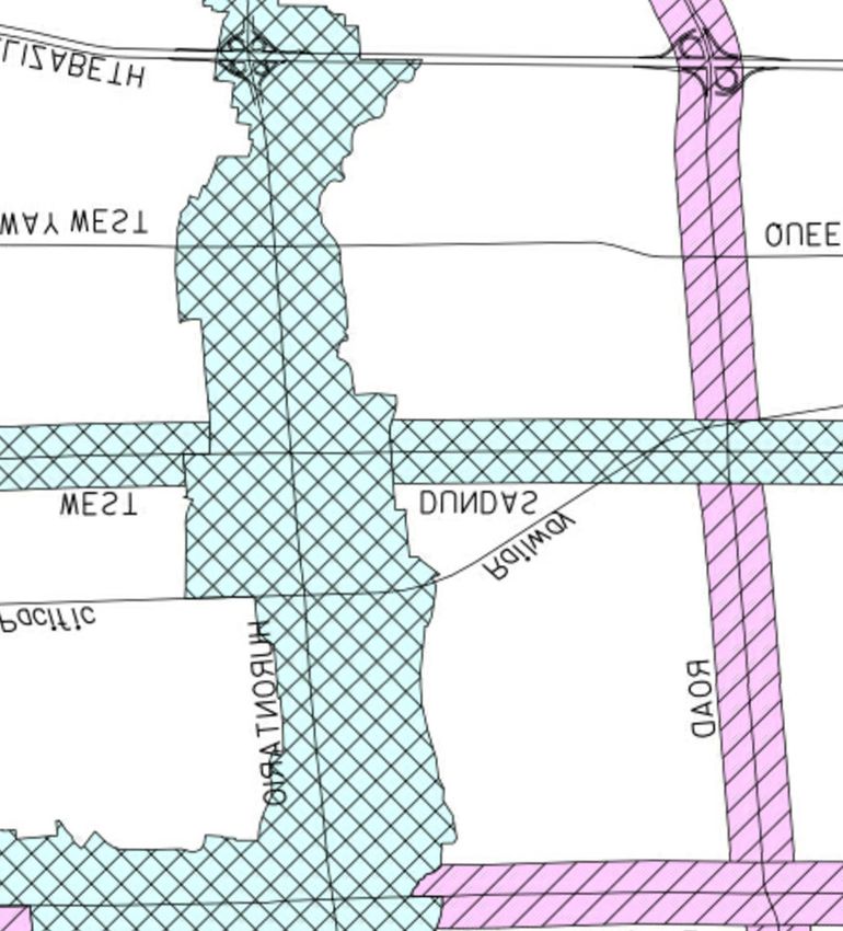
Glen Schnarr & Associates Inc.

                          Planning Justification Report
              Zoning By-Law Amendment and Draft Plan of Subdivision
                               0 King Street East,
                              City of Mississauga

1.0 INTRODUCTION
Glen Schnarr & Associates Inc. have been retained by City Park Holdings Inc. to assist in obtaining
the necessary planning approvals to permit the redevelopment of the lands municipally known as
0 King Street East in the City of Mississauga (herein referred to as the “subject property”). The
subject property is comprised of an assembly of seven (7) existing vacant lots.

City Park Holdings Inc. is proposing to redevelop the subject property with twenty-four (24) single
detached freehold and condominium dwellings, nine of which have frontage on King Street East
and Camilla Road and fifteen (15) of which will be accessed from an internal common element
condominium road (the “proposed development”).

This Planning Justification Report (the “Report”) has been prepared to assess the proposed Zoning
By-Law Amendment application (the “proposed Amendment”) required to permit the proposed
development and to bring the subject property into conformity and consistency with the City’s
Official Plan, Region of Peel Official Plan and Provincial planning policy. The Draft Plan of
Subdivision application is required to facilitate the creation of blocks and lotting associated with
the proposed development.

1.1 Proposed Zoning By-Law Amendment
The subject property is currently zoned “Residential- R3” by the City of Mississauga Zoning By-
Law 0225-2007 (the “Zoning By-Law”) which permits single detached dwellings. The amendment
to the City of Mississauga Zoning By-Law is required to permit the proposed 24 single detached
residential dwellings by rezoning the subject property to “R5-XX” and “R16-XX.” The proposed
Zoning By-Law Amendment is attached as Appendix I to this Report.

The freehold dwellings are proposed to be zoned “R5-XX.” The proposed Zoning By-Law
Amendment will provide for the following site-specific provisions to the R5 zone:

    •   Minimum Lot Area – Interior Lot: 230 m2, Corner Lot: 245 m2
    •   Minimum Lot Frontage, Corner Lot – 10.0 meters
    •   Maximum Height – 11.0 meters
    •   Minimum Rear Yard – 6.0 meters

The condominium dwellings will be zoned “R16-XX.” As such, the proposed Zoning By-Law
Amendment will provide for the following site-specific provisions:

    •   Minimum Lot Area – Interior Lot: 230 m2, Corner Lot: 227 m2

                                                                                                  4
0 King Street East, City ofMississauga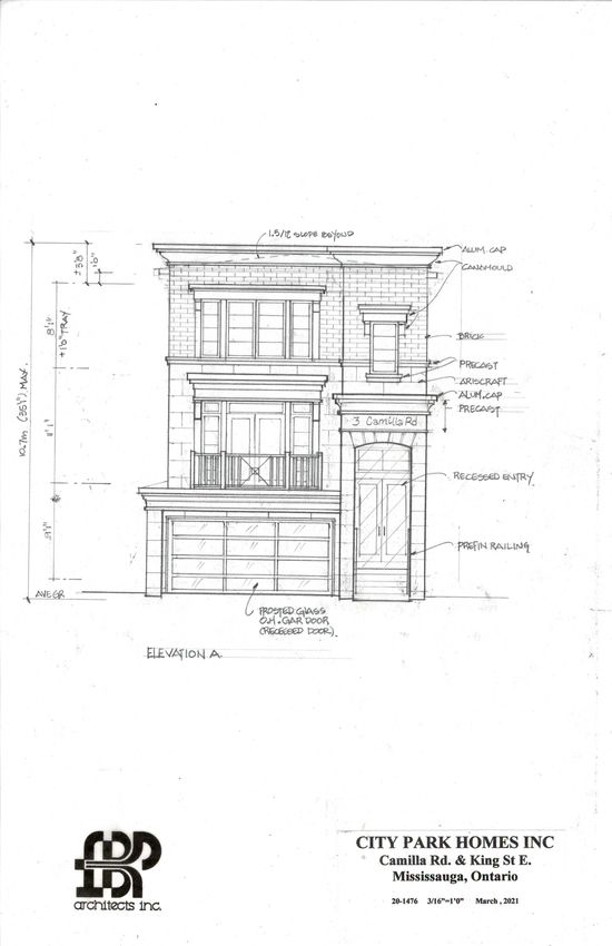
Glen Schnarr & Associates Inc.

    •   Minimum Lot Frontage, Interior Lot – 6.8 meters
    •   Minimum Lot Frontage, Corner Lot – 10 metres
    •   Maximum Lot Coverage – 46%
    •   Minimum Front Yard – 4.5 meters
    •   Maximum Height – 11.0 meters
    •   Minimum Rear Yard – 6.0 meters

The proposed development provides for a single detached housing form compatible with the
existing single detached housing context prevalent in the immediate surrounding area. The site-
specific Zoning By-law Amendment is required to address the siting of the houses on the subject
property and the configuration on the condominium road. This Report demonstrates how the
proposed Zoning By-Law Amendment will bring the subject property into consistency and
conformity with Provincial and Regional plans and policies and how the proposed development
contributes to the creation of complete communities and represents good planning.

1.2 Proposed Draft Plan of Subdivision
A Draft Plan of Subdivision is required to create the Blocks and Lots associated with the proposed
development. The proposed Draft Plan of Subdivision (the “Draft Plan”) will create eleven (11)
Blocks within the existing subject property gross site area of 0.73 hectares (1.81 acres). Lots 1-6
which have frontage on King Street East and Lots 7-9 which front onto Camilla Road have a net
site area of 0.22 hectares (0.55 acres) and constitute the nine (9) freehold dwelling units. Block 10
will contain the condominium detached residential lots with fifteen (15) dwelling units and has a
area of 0.50 hectares (1.24 acres). The road widening (Block 11) comprises 0.006 hectares (0.015
acres) of frontage nearest King Street East.

1.3 Process and Engagement
A Pre-Consultation meeting was held with City of Mississauga staff on December 9, 2020 to
present a preliminary concept of the proposed development and to determine the materials required
to satisfy a complete application submission. The proposed strategy for consulting with the public
will follow the requirements of the Planning Act for a statutory meeting as well as the requirements
for a Zoning By-law Amendment and Draft Plan of Subdivision.

At the time of authoring this Report, the City of Mississauga is following the advice and direction
provided by the provincial and regional Medical Officers of Health and has enacted a State of
Emergency and has implemented emergency planning operations, including closing facilities and
focusing efforts on delivering essential services as a result of COVID-19. Accordingly, the City is
currently subject to operational restrictions which prohibit public gatherings in large groups,
including information and formal statutory public meetings. In order to advance the application
through the Planning approvals process, the City is consulting with the Province on alternative
measures for community engagement. The applicant is open to exploring interim options to
facilitate public consultation in collaboration with City staff. In additional to the online notices
posted by staff, the provision of comment responses sheets (through an online forum) and online

                                                                                                   5
0 King Street East, City ofMississauga
Glen Schnarr & Associates Inc.

meetings in lieu of a formal statutory public meeting, should the City deem these satisfactory and
in the public interest.

                                                                                                6
0 King Street East, City ofMississauga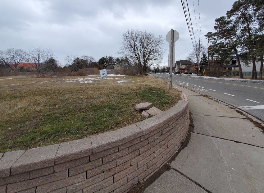
Glen Schnarr & Associates Inc.

2.0 SITE CONTEXT AND SURROUNDING AREA
The following sections describe the subject property’s existing site context and the immediate and
surrounding land uses.

2.1 Site Context (Subject Property)
The subject property is located on the south side of King Street East and on the east side of Camilla
Road, approximately 500 meters southeast of the intersection of Hurontario Street and Dundas
Street East (refer to Figure 1 – Aerial Context Plan). The subject property comprises a
consolidation of seven (7) existing Lots for a total site area of 0.73 hectares (1.80 acres) with a
frontage of approximately 60 meters (197 feet) along King Street East and a frontage of
approximately 87 meters (285 feet) along Camilla Road. The grade is lower in the southeast corner
of the subject property and slowly inclines to the northwest corner of the property – which is the
highest grade located on site. An existing retaining wall is located at the northeast corner of the
subject property at the King Street East and Camilla Road intersection. The retaining wall slowly
declines when moving south or east from the intersection. There are currently sidewalks on both
sides of Camilla Road while there is one sidewalk on the opposite side of the street along King
Street East. The property contains many small shrubs and some trees scattered across the property.

                 Image 1: Retaining wall (View looking South on Camilla Road)

                                                                                                   7
0 King Street East, City ofMississauga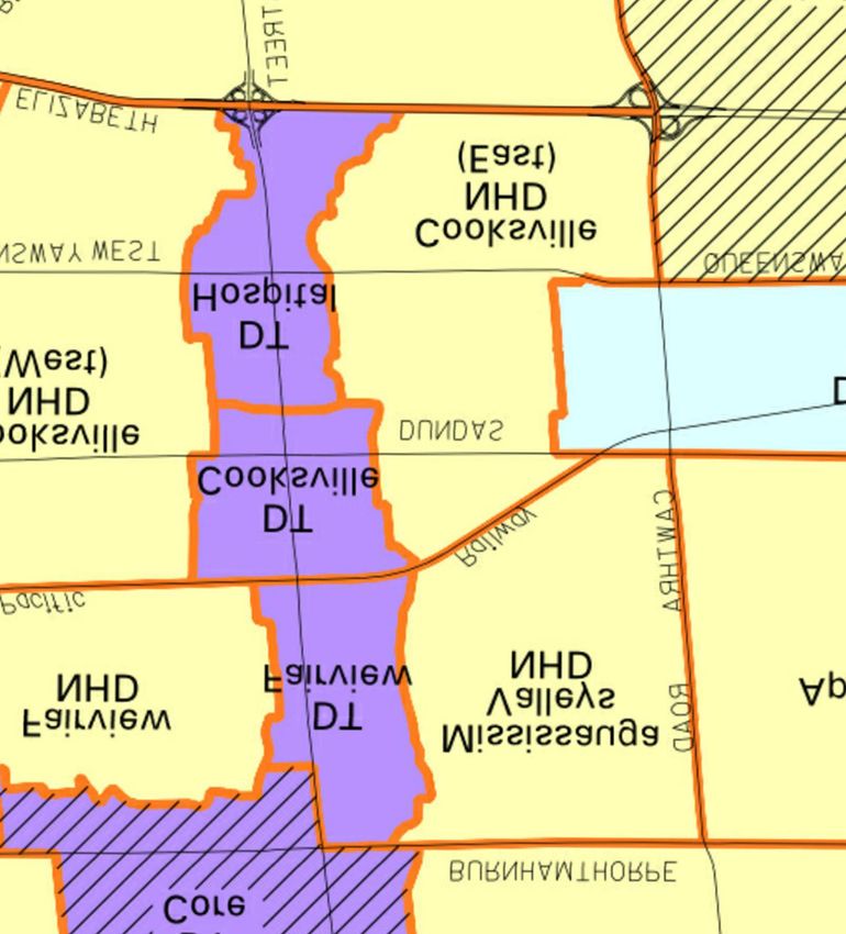
Glen Schnarr & Associates Inc.

                        Image 2: View looking North on Camilla Road

               Image 3: View from subject property looking East on King Street

                                                                                 8
0 King Street East, City ofMississauga
Glen Schnarr & Associates Inc.

The subject property is currently vacant and consists of 7 parcels of land. They are legally
described as follows:

   •   PART BLOCK A, PLAN A27, PART 1 PLAN 43R35508 CITY OF MISSISSAUGA
   •   PART BLOCK A, PLAN A27, PART 2 PLAN 43R35508 CITY OF MISSISSAUGA
   •   PART BLOCK A, PLAN A27, PART 3 PLAN 43R35508 CITY OF MISSISSAUGA
   •   PART BLOCK A, PLAN A27, PART 4 PLAN 43R35508 CITY OF MISSISSAUGA
   •   PART BLOCK A, PLAN A27, PART 5 PLAN 43R35508 CITY OF MISSISSAUGA
   •   PART BLOCK A, PLAN A27, PART 6 PLAN 43R35508 CITY OF MISSISSAUGA
   •   PART BLOCK A, PLAN A27, PART 7 PLAN 43R35508 CITY OF MISSISSAUGA

2.1.1 Road Widening
The subject property is located along King Street East which has a planned for a designated right-
of-way width of 26 meters. To achieve the City’s planned for right-of-way width of 26 meters, a
land dedication of 62.33 m2 has been accommodated on the subject property’s frontage with King
Street East. The resultant net site area of the subject property is 0.73 hectares (1.81 acres).

2.2 Surrounding Area Context
The subject property is located in the Cooksville Neighbourhood (NHD) East in the City of
Mississauga and is just outside of and at the limit of the Downtown (DT) Cooksville
Neighbourhood boundary. The immediate area surrounding the subject property generally consists
of detached residential homes. The Cooksville Creek is located to the west of the subject property.
Within the DT Cooksville area and at the intersection of Dundas Street and Hurontario Street
(located approximately 500 meters from the subject property) commercial, retail, and medium and
high density apartment uses exist (see Figure 2 – Surrounding Context Plan).

A summary of surrounding land uses is provided below:

       North:         The property immediately north of the subject property consists of a single
                      detached residential dwelling. Further north are additional low-density,
                      residential dwellings beyond which are commercial buildings with
                      frontages along Dundas Street East.

       East:          Lands east of the subject property are also characterized by existing low-
                      density residential dwellings and a primary school. Further east are
                      additional low-density residential dwellings and another primary school.

       South:         Low-density, single detached residential dwellings exist along Camilla
                      Road and Catherine Jean Lane, beyond which is Cooksville Park. Further
                      south, higher density residential buildings exist along Hurontario Street.

                                                                                                 9
0 King Street East, City ofMississauga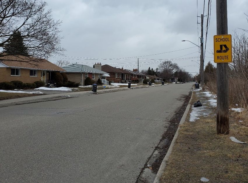
Glen Schnarr & Associates Inc.

       West:         A commercial use exists west of the subject property, with additional low-
                     density single-family dwellings. Beyond this exists higher density
                     residential buildings with commercial uses located along Hurontario Street.

                 Image 4: Residential dwellings North ofthe Subject Property

                                                                                             10
0 King Street East, City ofMississauga
Glen Schnarr & Associates Inc.
Image 5: Commercial Use West ofthe Subject Property
2.3 Recent Development Applications
The surrounding area is growing with the introduction of additional residential uses of varying
densities and built forms that continue to shape the neighborhood character. The table below
summarizes relevant and recent applications in the area and on Camilla Road and King Street East.
Table 1: Recent Development Applications
Address Application Description Stage
2371, 2385 Camilla Zoning By-Law 9 residential Approved
Road and 176, 180, Amendment condominium single
185, 189, 193, 197, detached dwelling
201, 205, and 209 units
Mateo Place
2487 Camilla Road Site Plan 2 storey infill Withheld
dwelling on vacant
land
2476 & 2482 Zoning By-Law 4 semi-detached In Process
Confederation Pkwy Amendment dwellings
2560 and 2564 Zoning By-Law 4 live-work Approved
Confederation Parkway Amendment townhouse units
2020-2040 Camilla H-Removal and Site 148 stacked and In Process
Road Plan back-to-back
townhouse dwellings
11
0 King Street East, City ofMississaugaGlen Schnarr & Associates Inc.
An illustration of primary surrounding land uses is shown on Figure 2 – Surrounding Context
Plan.
12
0 King Street East, City ofMississaugaGlen Schnarr & Associates Inc.
3.0 TRANSPORTATION AND SERVICES
The following section describes the subject property’s location within the transportation network
as well as the amenities and facilities available to service future residents of the proposed
development.
3.1 Roads, Transit and Connectivity
King Street East and Camilla Road are both designated “Minor Collector” by the City of
Mississauga Official Plan. Dundas Street East and Hurontario Street, located approximately 500
meters from the subject property, are both designated “Arterial.” Additionally, the subject property
is within walking distance of bus transit service, approximately 400 meters from a bus stop at King
Street East and Sheppard Avenue (Route No. 4) and approximately 500 meters from a bus stop at
King Street East and Hurontario Street (Route No. 2 and 4). The Cooksville GO Train Station is
located approximately 1000 metres from the subject property and the future Hurontario/Dundas
Light Rail Transit (LRT) Station is less than 500 metres (1,968 feet) from the subject property.
The intersection of Hurontario and Dundas Street is a Major Transit Station Area (MTSA) which
is planned for growth and provides a range of active transportation options.
Bus routes No. 2 and 4 offer the following service (refer to Figure 3 – Community Amenities,
Transportation and Services Map):
• The 2 Hurontario Bus Route is a local route which generally operates from Monday to
Sunday travelling in a north south direction. The route provides a connection from City
Centre Transit Terminal at Square One to Port Credit GO Station.
• The 4 Sherway Gardens Bus Route is a local route which generally operate from Monday
to Sunday travelling in an east west direction. The route provides a connection from
Glengarry Road near Westdale Mall to Sherway Gardens.
Active transportation infrastructure is planned to increase in the neighbourhood through increased
bicycle lanes and additional infrastructure. Currently, Camilla Road has a marked bike lane and
sidewalks on both sides of the street. King Street East currently has a sidewalk on the opposite
side of the street from the subject property. The City of Mississauga has identified Long Term
Cycling Routes along Hurontario Road, Dundas Street West and McLaughlin Road.
3.2 Facilities, Services, and Recreation
The summary below provides a list of facilities, services, institutional and recreational
opportunities/centers within an approximate one-kilometer radius from the subject property. With
the subject property situated within the Cooksville Neighbourhood, it is serviced by transit and has
access to a variety of public and private amenities that are also within walking distance for
residents (refer to Figure 3 – Community Amenities, Transportation and Services Map).
13
0 King Street East, City ofMississaugaGlen Schnarr & Associates Inc.
Table 2 – Nearby Facilities, Services and Recreation
Parks and Recreational Centers
Cooksville Park
Oaks Park
Ashwood Park
Arirang Age-Friendly Community Centre
Schools
TEAM School
Clifton Public School
Thompson Career College
Corsair Public School
Saint Timothy School
Elementary/Ontario Secondary School
St. Catherine of Siena Elementary School
Community Amenities
Cooksville Library
Mississauga Fire Station 110
Service Ontario
Cooksville Community Hub
As shown in Table 2 - Facilities, Services and Recreation and the Facilities, Service and
Recreation Map (and refer to Figure 3 – Transportation and Services of this Report), the subject
property is located within a vibrant area of the City with access to numerous facilities, services
and recreational opportunities which support the surrounding residential areas and contributes to
a complete community.
14
0 King Street East, City ofMississaugaGlen Schnarr & Associates Inc.
4.0 DEVELOPMENT PROPOSAL
4.1 Description of Proposed Development
City Park Holdings Inc. is proposing to redevelop the subject property with twenty-four (24) single
detached residential dwellings, nine (9) of which will have frontage on public roads and fifteen
(15) of which will be accessed from an internal private condominium road. This proposed
development is further described below.
4.1.1 Freehold Lots
Proposed residential Lots 1-6 and 22-24 (9 dwelling units) will occupy a total site area of
approximately 0.22 hectares (0.55 acres) with Lots 1-6 fronting onto King Street East and Lots 22-
24 fronting onto Camilla Road. The houses are proposed to be 10.7 meters (35.1 feet) in height,
standing 2 ½ storeys tall. Individual driveway access with accommodation for two cars will be
provided for each home and a two car garage will also be provided. The minimum lot area for
interior lots will be 230 m2 while corner lots will have a 245 m2 minimum. The proposed maximum
GFA of the units varies from 232.25 m2 to 260.13 m2.
Garbage collection will be facilitated by curb side waste collection from each respective property
on King Street East and Camilla Road.
4.1.2 Common Element Condominium Lots
Proposed residential Lots 7-21 (15 dwelling units) will front onto a private road internal to the site
and will occupy a total site area of 0.50 hectares (1.24 acres). The houses are proposed to be 10.7
meters (35.1 feet) in height, standing 2 ½ storeys tall. Individual driveway access with
accommodation for two cars will be provided for each home and a two car garage will also be
provided. Additionally, four (4) visitor parking spaces will also be provided on site. The minimum
lot area for interior lots will be 227 m2. The proposed maximum GFA of the units varies from
198.30 m2 to 260.13 m2.
Garbage collection will be facilitated by curb side waste collection from each respective property
along the private road.
4.2 Architecture and Elevations
A blend of Beacon Hill Brownstone and contemporary architectural elements adapted and
proportioned for this urban enclave development. A characteristic luxurious design using a tasteful
combination of quarried smooth stonelike material and clay brick with a balanced composition of
architectural elements. Large windows and open floor plans ensure an interior with abundant
natural light. The units will be 10.7 meters in height, in line with the character of the neighbouring
residential units.
15
0 King Street East, City ofMississaugaGlen Schnarr & Associates Inc.
4.3 Statistics
The proposed development statistics have been summarized in a chart below.
Table 3 – Statistics ofSite and Proposed Development
Site Statistics
Gross Site Area 0.73 hectares (1.79 acres)
Road Widening 62.33 m2
Net Site Area 0.73 hectares
Freehold Lots 1-6 and 22-24
Dwelling Units 9
Net Site Area 0.22 hectares (0.55 acres)
Building Coverage 41.63%
Density 40.34 units per net hectare (16.36 units per net
acre)
Parking Spaces 36
Common Element Condominium Lots 7-21
Dwelling Units 15
Net Site Area 0.50 hectares (1.24 acres)
Building Coverage 30.30%
Density 29.89 units per net hectare (12.10 units per net
acre)
Total Parking Spaces (includes visitors) 60
Visitor Parking (incl. accessible parking) 4
Overall Proposed Development
Total Dwelling Units 24
Total Gross Floor Area 0.58 hectares (1.54 acres)
Total Building Coverage 0.25 hectares (0.61 acres)
Maximum Building Height 11.0 meters
Density 32.88 (33) units per net hectare (13.41 units per
acre)
FSI 0.79
Total Parking Spaces (garages, driveways, 100
visitor parking)
16
0 King Street East, City ofMississaugaGlen Schnarr & Associates Inc.
5.0 POLICY CONTEXT AND ANALYSIS
As required by Sections 2 and 3 of the Planning Act, the following Section demonstrates the
proposed development’s consistency with the Provincial Policy Statement (2020) and conformity
with the Places to Grow: Growth Plan for the Greater Golden Horseshoe (2019), the Region of
Peel Official Plan (2016), the City of Mississauga Official Plan (2018), and demonstrates how the
proposed Zoning By-law Amendment will bring the City of Mississauga Zoning By-law 0225-
2007 into conformity with Provincial planning policy, the Official Plan and how the proposed
development will achieve good planning and contribute to the creation of complete communities
overall.
5.1 Provincial Policy Statement (2020)
Section 3 of the Planning Act requires that planning authorities “shall be consistent” with the
Provincial Policy Statement (the “PPS”) when exercising any authority that affects a planning
matter.
The Provincial Policy Statement, 2020, states that Ontario’s long-term prosperity depends on a
coordinated approach for wisely managing change and promoting efficient development patterns
that result in strong, healthy and complete communities. This is achieved by balancing
environmental protection, public health, and safety while creating economically sustainable built
environments. In this regard, the PPS provides for a high-level policy foundation that promotes
and enhances the concept of a complete community.
The PPS promotes efficient development patterns by directing growth to settlement areas and
discouraging unnecessary and inefficient expansion of these areas. It does so by encouraging the
effective use of existing and planned infrastructure and by accommodating a mix of land uses.
Complete Communities
With respect to complete community development, the PPS provides the following policies:
1.1.1 Healthy, liveable and safe communities are sustained by:
a) promoting efficient development and land use patterns which sustain the
financial well-being ofthe Province and municipalities over the long term;
b) accommodating an appropriate affordable and market-based range and
mix of residential types (including single-detached, additional residential
units, multi-unit housing, affordable housing and housing for older
persons), employment (including industrial and commercial), institutional
(including places of worship, cemeteries and long-term care homes),
recreation, park and open space, and other uses to meet long-term needs;
c) avoiding development and land use patterns which may cause
environmental or public health and safety concerns;
17
0 King Street East, City ofMississaugaGlen Schnarr & Associates Inc.
d) avoiding development and land use patterns that would prevent the
efficient expansion ofsettlement areas in those areas which are adjacent or
close to settlement areas;
e) promoting the integration of land use planning, growth management,
transit-supportive development, intensification and infrastructure planning
to achieve cost-effective development patterns, optimization of transit
investments, and standards to minimize land consumption and servicing
costs;
f) improving accessibility for persons with disabilities and older persons by
addressing land use barriers which restrict their full participation in
society;
g) ensuring that necessary infrastructure and public service facilities are or
will be available to meet current and projected needs;
h) promoting development and land use patterns that conserve biodiversity;
and
i) preparing for the regional and local impacts ofa changing climate.
The proposed development is an efficient design for healthy, efficient development within a
Settlement Area identified for growth by the Growth Plan. The proposed single detached dwellings
can accommodate young families looking to upsize while relating to the existing built form of
single detached houses. The proposed density of 32.88 units per net hectare (13.41 units per acre)
will provide a transit supportive density and cost-effective development pattern to best optimize
existing infrastructure while still maintaining the single-family detached context.
Settlement Areas
In accordance with Policy 1.1.3.1, Settlement Areas shall be the focus of growth and development.
Specifically, Policy 1.1.3 includes the following:
1.1.3.2 Land use patterns within settlement areas shall be based on:
a) densities and a mix ofland uses which:
a) efficiently use land and resources;
b) are appropriate for, and efficiently use, the infrastructure and
public service facilities which are planned or available, and avoid
the need for their unjustified and/or uneconomical expansion;
18
0 King Street East, City ofMississaugaGlen Schnarr & Associates Inc.
c) minimize negative impacts to air quality and climate change, and
promote energy efficiency;
d) prepare for the impacts ofa changing climate;
e) support active transportation;
f) are transit-supportive, where transit is planned, exists or may be
developed; and
g) are freight supportive.
Land use patterns within settlement areas shall also be based on a range of
uses and opportunities for intensification and redevelopment in accordance
with the criteria in policy 1.1.3.3 where this can be accommodated.
The proposed development is located in an existing Settlement Area, will support active
transportation and public transit as a result of the subject property’s proximity to existing bus stops,
transportation hubs (Cooksville GO and future LRT Major Transit Station Area at
Dundas/Hurontario), walkways, bike lanes and the trail system which all provide for the use of
alternative modes of transportation, potentially reducing greenhouse gas emissions (see Figure 3
– Community Amenities, Transportation & Services Map).
1.1.3.3 Planning authorities shall identify appropriate locations and promote
opportunities for transit-supportive development, accommodating a
significant supply and range ofhousing options through intensification and
redevelopment where this can be accommodated taking into account
existing building stock or areas, including brownfield sites, and the
availability ofsuitable existing or planned infrastructure and public service
facilities required to accommodate projected needs.
1.1.3.4 Appropriate development standards should be promoted which facilitate
intensification, redevelopment and compact form, while avoiding or
mitigating risks to public health and safety.
1.1.3.6 New development taking place in designated growth areas should occur
adjacent to the existing built-up area and should have a compact form, mix
of uses and densities that allow for the efficient use of land, infrastructure
and public service facilities.
The subject property represents an excellent and appropriate opportunity for redevelopment as it
is currently vacant, located in an area with existing services and infrastructure and is within
walking distance to a regional GO Train Station (Cooksville) and future LRT station, several local
bus stops and walking and cycling infrastructure already in place. As such, subject property is
currently underutilized and its locational attributes are well suited for intensification. The proposed
development will make the most efficient use of land in this location and is transit-supportive.
19
0 King Street East, City ofMississaugaGlen Schnarr & Associates Inc.
The proposed development supports the efficient use of public investments in infrastructure such
as the existing roads, sidewalks and trails, municipal water and sewage infrastructure. The
proposed residential development is compact in form yet compatible with existing single detached
context in the surrounding neighbourhood. There are no anticipated negative impacts to public
health and safety. The proposed development is therefore consistent with Sections 1.1.1 and 1.1.3
of the PPS.
Housing
Section 1.4 of the PPS 2014 provides policies relating to housing:
1.4.1 To provide for an appropriate range and mix of housing options and
densities required to meet projected requirements of current and future
residents ofthe regional market area, planning authorities shall:
a) maintain at all times the ability to accommodate residential growth for a
minimum of15 years through residential intensification and redevelopment
and, ifnecessary, lands which are designated and available for residential
development; and
b) maintain at all times where new development is to occur, land with
servicing capacity sufficient to provide at least a three-year supply of
residential units available through lands suitably zoned to facilitate
residential intensification and redevelopment, and land in draft approved
and registered plans.
1.4.3 Planning authorities shall provide for an appropriate range and mix of
housing options and densities to meet projected market-based and
affordable housing needs of current and future residents of the regional
market area by:
a) establishing and implementing minimum targets for the provision of
housing which is affordable to low and moderate income households and
which aligns with applicable housing and homelessness plans. However,
where planning is conducted by an upper-tier municipality, the upper-tier
municipality in consultation with the lower-tier municipalities may identify
a higher target(s) which shall represent the minimum target(s) for these
lower-tier municipalities;
b) permitting and facilitating:
1. all housing options required to meet the social, health, economic
and well-being requirements of current and future residents,
including special needs requirements and needs arising from
demographic changes and employment opportunities; and
20
0 King Street East, City ofMississaugaGlen Schnarr & Associates Inc.
2. all types of residential intensification, including additional
residential units, and redevelopment in accordance with policy
1.1.3.3;
c) directing the development of new housing towards locations where
appropriate levels ofinfrastructure and public service facilities are or will
be available to support current and projected needs;
d) promoting densities for new housing which efficiently use land,
resources, infrastructure and public service facilities, and support the use
of active transportation and transit in areas where it exists or is to be
developed;
e) requiring transit-supportive development and prioritizing intensification,
including potential air rights development, in proximity to transit, including
corridors and stations; and
f) establishing development standards for residential intensification,
redevelopment and new residential development which minimize the cost of
housing and facilitate compact form, while maintaining appropriate levels
ofpublic health and safety.
The proposed development consists of freehold detached and common element detached dwellings
that represent an appropriate form of low-rise intensification within an existing neighbourhood
that is served by existing services, transit and infrastructure. The proposed development is of a
compact form which effectively utilizes existing infrastructure and public service facilities. The
proposed development contributes to the range and mix of market housing options available to the
community while maintaining compatibility with the surrounding neighbourhood. The proposed
development is consistent with the Housing policies of the PPS.
Complete Communities
Policy 1.5 of the PPS contains policies to ensure the creation of healthy, active communities,
relevant policies include:
1.5.1 Healthy, active communities should be promoted by:
a) planning public streets, spaces and facilities to be safe, meet the needs of
pedestrians, foster social interaction and facilitate active transportation
and community connectivity;
b) planning and providing for a full range and equitable distribution of
publicly accessible built and natural settings for recreation, including
facilities, parklands, public spaces, open space areas, trails and linkages,
and, where practical, water-based resources;
21
0 King Street East, City ofMississaugaGlen Schnarr & Associates Inc.
The proposed development contributes to the creation of healthy and active communities by
creating opportunities for people to enjoy an active lifestyle by utilizing the subject property’s
location adjacent to and nearby existing sidewalks, walkways, bike lanes and trails. As seen in
Figure 3- Community Amenities, Transportation & Services Map, there are many parks and trails
located in the area. Cooksville Park and Oaks Park both have playgrounds and are located within
500 meters of the subject property and Cooksville Park contains a walking trail along Cooksville
Creek. These amenities are all easily accessible via active transportation options including
sidewalks along King Street East and Camilla Road, a bike lane on Camilla Road, and Bus Route
No. 4 on Camilla Road. These options all support healthy and active communities through the use
of active transportation options. The proposed development is therefore consistent with Section
1.5.1 of the PPS.
Infrastructure and Public Service Facilities
Policy 1.6.6.1 and 1.6.6.2 of the PPS contains policies regarding infrastructure and public service
facilities and relevant policies include:
1.6.6.1 Planning for sewage and water services shall:
a) accommodate forecasted growth in a manner that promotes the efficient
use and optimization ofexisting:
1. municipal sewage services and municipal water services;
b) ensure that these systems are provided in a manner that:
1. can be sustained by the water resources upon which such
services rely;
2. prepares for the impacts ofa changing climate;
3. is feasible and financially viable over their lifecycle; and
4. protects human health and safety, and the natural environment;
c) promote water conservation and water use efficiency;
d) integrate servicing and land use considerations at all stages ofthe
planning process; and
1.6.6.2 Municipal sewage services and municipal water services are the preferred
form of servicing for settlement areas to support protection of the
environment and minimize potential risks to human health and safety.
within settlement areas with existing municipal sewage services and
municipal water services, intensification and redevelopment shall be
promoted wherever feasible to optimize the use ofthe services.
Additionally, policy 1.6.6.7 promotes efficient stormwater management practices to minimize
unnecessary expansion of infrastructure.
22
0 King Street East, City ofMississaugaGlen Schnarr & Associates Inc.
1.6.6.7 Planning for stormwater management shall:
a) be integrated with planning for sewage and water services and
ensure that systems are optimized, feasible and financially viable
over the long term;
b) minimize, or, where possible, prevent increases in contaminant
loads;
c) minimize erosion and changes in water balance, and prepare for
the impacts ofa changing climate through the effective management
ofstormwater, including the use ofgreen infrastructure;
d) mitigate risks to human health, safety, property and the
environment;
e) maximize the extent and function of vegetative and pervious
surfaces; and
f) promote stormwater management best practices, including
stormwater attenuation and re-use, water conservation and
efficiency, and low impact development.
The proposed development will make efficient use of existing infrastructure and municipal
services. The Functional Servicing Report prepared by Skira & Associates Ltd. demonstrates how
the proposed development will connect with existing infrastructure to service the homes. Quality
control will be achieved through the use of oversized storm sewers, a cultect system and 74mm
orifice restrictor plate. The proposed development will make use of the existing public roads by
proposing six freehold detached dwellings on King Street and three (3) freehold detached
dwellings on Camilla Road. There are no anticipated impacts to public health and safety. The Low
Impact Development (“LID”) features include increasing the topsoil depth to 300mm to improve
runoff retention to promote infiltration in the landscape areas, goss traps on the road catch basins,
permeable pavers on all driveways, and an oil/grit interceptor. The proposed development is
therefore consistent with Section 1.6 of the PPS.
Transportation Systems
The PPS reiterates the importance of land use patterns, densities and a mix of uses that support
transit and active transportation in Policy 1.6.7 – Transportation Systems:
1.6.7.1 Transportation systems should be provided which are safe, energy efficient,
facilitate the movement ofpeople and goods, and are appropriate to address
projected needs.
23
0 King Street East, City ofMississaugaGlen Schnarr & Associates Inc.
1.6.7.2 Efficient use should be made of existing and planned infrastructure,
including through the use oftransportation demand management strategies,
where feasible.
1.6.7.4 A land use pattern, density and mix of uses should be promoted that
minimize the length and number of vehicle trips and support current and
future use oftransit and active transportation.
The proposed development is consistent with Policy 1.6.7 as the development will be accessible
to existing transportation services and will utilize an existing public road. The subject property is
located within walking distance to several bus stops which provides for connections to major
transit terminals and GO stations (see Figure 3 – Community Amenities, Transportation & Services
Map). Opportunities for active transportation are plentiful with the Bus Route No. 4 on Camilla
Road, bike lanes on Camilla Road, and sidewalks on both Camilla Road and King Street East.
Once the proposed Hurontario LRT is built, it will provide additional transportation options.
Furthermore, the Traffic Impact Study prepared by NexTrans dated April 2021 determined no
additional physical improvements will be required to the area road network and intersections to
accommodate the proposed improvements. Therefore, the proposed Zoning By-law Amendment
will support an efficient transportation system and is consistent with Policy 1.6.7 of the PPS.
Long Term Economic Prosperity
Policy 1.7 promotes the long-term economic prosperity through the preservation of resources,
redevelopment of lands to enhance the economy and relevant policies include:
1.7.1 Long-term economic prosperity should be supported by:
b) encouraging residential uses to respond to dynamic market-based needs
and provide necessary housing supply and range of housing options for a
diverse workforce;
c) optimizing the long-term availability and use of land, resources,
infrastructure and public service facilities;
e) encouraging a sense ofplace, by promoting well-designed built form and
cultural planning, and by conserving features that help define character,
including built heritage resources and cultural heritage landscapes;
The proposed development is consistent with Policy 1.7 through proposing and contributing to the
range of housing supply, single detached homes in this instance, which will contribute to the
overall housing supply in the Province. The proposed development will optimize an underutilized
parcel of residential land in an area with available servicing capacity and public service facilities.
The architectural drawings by FBP Architects Inc. provide a built form consistent with the heights
of rebuilt homes in the area and common in existing and older residential subdivisions in transition.
The proposed development is consistent with Policy 1.7 of the PPS.
24
0 King Street East, City ofMississaugaGlen Schnarr & Associates Inc.
The proposed development is consistent with the above noted policies of the PPS as it promotes
the creation of livable complete communities, represents and efficient use of land, infrastructure
and services and contributes to a mix of housing options within the existing built-up area. We have
reviewed all policies of the PPS and find that the proposed Zoning By-law Amendment is
consistent with the policies of the PPS.
5.2 The Growth Plan for the Greater Golden Horseshoe (2019)
The Growth Plan for the Greater Golden Horseshoe (the “Growth Plan”) is intended to be a
framework for implementing the Province’s vision for supporting strong prosperous communities
through managing growth in the Region through 2041. The 2019 Growth Plan builds from the
progress of the former plan and provides stronger policies regarding the importance of optimizing
the use of land and infrastructure as well as the achievement of complete communities.
The subject property is located within an identified “Built-up Area,” being the City of Mississauga.
Intensification is encouraged within Built-up Areas where infrastructure and public service
facilities are available, so long as appropriate land use compatibility and transition of built forms
is achieved.
Guiding Principles
Policies 1.2 of the Growth Plan contain policies regarding the overall guiding principles for the
plan and relevant policies include:
1.2.1
• Support the achievement of complete communities that are designed to support
healthy and active living and meet people’s needs for daily living throughout an
entire lifetime.
• Support a range and mix ofhousing options, including second units and affordable
housing, to serve all sizes, incomes, and ages ofhouseholds
.
• Protect and enhance natural heritage, hydrologic, and landform systems, features,
and functions.
The proposed development contributes to the achievement of complete communities by
contributing an in-demand housing type to an existing established community that has plentiful
services and resources for residents.
Managing Growth
Policies 2.2.1 of the Growth Plan contain policies regarding managing the growth of communities
and relevant policies include:
2.2.1.2 Forecasted growth to the horizon ofthis Plan will be allocated based on the
following:
25
0 King Street East, City ofMississaugaGlen Schnarr & Associates Inc.
a) the vast majority ofgrowth will be directed to settlement areas that:
i. have a delineated built boundary;
ii. have existing or planned municipal water and wastewater
systems; and
iii. can support the achievement ofcomplete communities;
b) growth will be limited in settlement areas that:
i. are rural settlements;
ii. are not serviced by existing or planned municipal water and
wastewater systems; or
iii. are in the Greenbelt Area;
c) within settlement areas, growth will be focused in:
i. delineated built-up areas;
iii. locations with existing or planned transit, with a priority on
higher order transit where it exists or is planned; and
iv. areas with existing or planned public service facilities;
e) development will be generally directed away from hazardous lands;
The subject property is in a Settlement Area and Built-up Area and is also within one kilometer of
the Cooksville GO Train station and approximately 500 metres from the future Hurontario LRT.
Local buses also service the subject property. Existing infrastructure and public service facilities
including schools and community centres are available to service the proposed development. The
proposed Zoning By-law Amendment therefore conforms with Section 2.2.1 of the Growth Plan.
2.2.1.4 Applying the policies ofthis Plan will support the achievement ofcomplete
communities that:
a) feature a diverse mix of land uses, including residential and
employment uses, and convenient access to local stores, services,
and public service facilities;
b) improve social equity and overall quality oflife, including human
health, for people ofall ages, abilities, and incomes;
c) provide a diverse range and mix of housing options, including
additional residential units and affordable housing, to
accommodate people at all stages of life, and to accommodate the
needs ofall household sizes and incomes;
d) expand convenient access to:
26
0 King Street East, City ofMississaugaGlen Schnarr & Associates Inc.
i. a range oftransportation options, including options for the
safe, comfortable and convenient use of active
transportation;
ii. public service facilities, co-located and integrated in
community hubs;
iii. an appropriate supply of safe, publicly-accessible open
spaces, parks, trails, and other recreational facilities; and
iv. healthy, local, and affordable food options, including
through urban agriculture;
e) provide for a more compact built form and a vibrant public realm,
including public open spaces;
f) mitigate and adapt to the impacts ofa changing climate, improve
resilience and reduce greenhouse gas emissions, and contribute to
environmental sustainability; and
g) integrate green infrastructure and appropriate low impact
development.
The proposed development contributes to the diverse mix of land uses in the area and contributes
new forms and tenures of housing stock to an already established and well-serviced
neighbourhood. The subject property is serviced by local and regional transportation and active
transportation options including biking and walking routes along existing streets and on dedicated
pathways. The proposed development has a compact built-form and is accessible to several
existing transit options which will help to reduce dependence on the automobile. The proposed
Zoning By-law Amendment therefore conforms with Section 2.2.1.4 of the Growth Plan.
Delineated Built-Up Areas
Policies 2.2.2 of the Growth Plan contains policies regarding the delineation of built-up areas and
relevant policies include:
2.2.2.1 By the time the next municipal comprehensive review is approved and in
effect, and for each year thereafter, the applicable minimum intensification
target is as follows:
a) A minimum of 50 per cent of all residential development
occurring annually within each of the Cities of Barrie, Brantford,
Guelph, Hamilton, Orillia and Peterborough and the Regions of
Durham, Halton, Niagara, Peel, Waterloo and York will be within
the delineated built-up area; and
2.2.2.2. Until the next municipal comprehensive review is approved and in effect,
the annual minimum intensification target contained in the applicable
27
0 King Street East, City ofMississaugaGlen Schnarr & Associates Inc.
upper- or single-tier official plan that is approved and in effect as ofJuly 1,
2017 will continue to apply.
The proposed development will assist the City in reaching the minimum target of 50% of
residential development occurring within a delineated Built-up Area, by developing an existing
underutilized property within the Built-up Area. The Zoning By-law Amendment therefore
conforms with Policy 2.2.2 of the Growth Plan.
Transit Corridors and Station Areas
Policies 2.2.4 of the Growth Plan contains policies regarding transit corridors and station areas and
the relevant policies include:
Major Transit Station Area Definition:
The area including and around any existing or planned higher order transit
station or stop within a settlement area; or the area including and around
a major bus depot in an urban core. Major transit station areas generally
are defined as the area within an approximate 500 to 800 metre radius ofa
transit station, representing about a 10-minute walk.
2.2.4.2 For major transit station areas on priority transit corridors or subway lines,
upper- and single-tier municipalities, in consultation with lower-tier
municipalities, will delineate the boundaries ofmajor transit station areas
in a transit-supportive manner that maximizes the size of the area and the
number of potential transit users that are within walking distance of the
station.
2.2.4.3 Major transit station areas on priority transit corridors or subway lines will
be planned for a minimum density target of:
b) 160 residents and jobs combined per hectare for those that are
served by light rail transit or bus rapid transit; or
c) 150 residents and jobs combined per hectare for those that are
served by the GO Transit rail network
2.2.4.8. All major transit station areas will be planned and designed to be transit
supportive and to achieve multimodal access to stations and connections to
nearby major trip generators by providing, where appropriate:
a) connections to local and regional transit services to support
transit service integration;
b) infrastructure to support active transportation, including
sidewalks, bicycle lanes, and secure bicycle parking; and
28
0 King Street East, City ofMississaugaYou can also read