PLANNING STATEMENT Inert Landfill and Construction and Demolition (C&D) Waste Recovery Facility Ballinclare Quarry, Kilbride, Co. Wicklow
←
→
Page content transcription
If your browser does not render page correctly, please read the page content below
PLANNING STATEMENT

                    Inert Landfill and Construction and Demolition (C&D)
                                                  Waste Recovery Facility

                                    Ballinclare Quarry, Kilbride, Co. Wicklow

                           Prepared for: Kilsaran Concrete Unlimited Company

SLR Ref: 501.00036.00080
Version No: FINAL
April 2021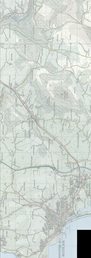
Kilsaran Concrete – Ballinclare Quarry, Kilbride, Co. Wicklow
Inert Landfill and C&D Waste Recovery Facility                                                                                          SLR Ref No: 501.00036.00080
Planning Statement                                                                                                                                        April 2021

        BASIS OF REPORT
                                                    This document has been prepared by SLR Consulting Ireland with reasonable skill, care and diligence, and taking account
                                                    of the manpower, timescales and resources devoted to it by agreement with Kilsaran Concrete Unlimited Company
                                                    (the Client) as part or all of the services it has been appointed by the Client to carry out. It is subject to the terms and
                                                    conditions of that appointment.

                                                    SLR shall not be liable for the use of or reliance on any information, advice, recommendations and opinions in this
                                                    document for any purpose by any person other than the Client. Reliance may be granted to a third party only in the
                                                    event that SLR and the third party have executed a reliance agreement or collateral warranty.

                                                    Information reported herein may be based on the interpretation of public domain data collected by SLR, and/or
                                                    information supplied by the Client and/or its other advisors and associates. These data have been accepted in good faith
                                                    as being accurate and valid.

                                                    The copyright and intellectual property in all drawings, reports, specifications, bills of quantities, calculations and other
                                                    information set out in this report remain vested in SLR unless the terms of appointment state otherwise.

                                                    This document may contain information of a specialised and/or highly technical nature and the Client is advised to seek
                                                    clarification on any elements which may be unclear to it.

                                                    Information, advice, recommendations and opinions in this document should only be relied upon in the context of the
                                                    whole document and any documents referenced explicitly herein and should then only be used within the context of
                                                    the appointment.

    .
Kilsaran Concrete – Ballinclare Quarry, Kilbride, Co. Wicklow
Inert Landfill and C&D Waste Recovery Facility                                                                                                            SLR Ref No: 501.00036.00080
Planning Statement                                                                                                                                                          April 2021

        CONTENTS
                INTRODUCTION ............................................................................................................... 1
        1.1     Overview ................................................................................................................................... 1
        1.2     The Applicant ............................................................................................................................ 1

                BACKGROUND TO APPLICATION ...................................................................................... 3
        2.1     Site Location and Context ......................................................................................................... 3
        2.2     Site Description and Land Ownership ....................................................................................... 3
        2.3     Site Access ................................................................................................................................ 4
        2.4     Current Land Use ...................................................................................................................... 5
        2.5     Surrounding Land Use ............................................................................................................... 5
        2.6     Planning History ........................................................................................................................ 5
        2.6.1   Section 261 Quarry Registration (Quarry Ref. QY/4) ...................................................................................................... 7
        2.6.2   Section 261A Determination (Quarry Ref. S261A/QY/4) ................................................................................................ 7
        2.6.3   Planning History ................................................................................................................................................................ 7

        2.7     Planning Consultation ............................................................................................................... 8
        2.8     National and Local Designations ............................................................................................. 10
        2.8.1   Natura 2000, NHA and pNHA Sites ................................................................................................................................ 10
        2.8.2   Recorded Monuments ................................................................................................................................................... 10
        2.8.3   Built Heritage .................................................................................................................................................................. 11
        2.8.4   Landscape ....................................................................................................................................................................... 11
        2.8.5   Geological Heritage ........................................................................................................................................................ 11

                PROPOSED DEVELOPMENT ............................................................................................ 12
        3.1     Site Preparation / Establishment Works ................................................................................. 13
        3.2     Proposed C&D Waste Recovery Shed ..................................................................................... 14
        3.3     Soil Washing / Aggregate Recovery Plant ............................................................................... 14
        3.4     Phasing of Excavation and Backfilling Works .......................................................................... 15
        3.5     Intake Capacity and Expected Lifespan ................................................................................... 15
        3.6     Working Hours ........................................................................................................................ 16
        3.7     Employment............................................................................................................................ 16
        3.8     Traffic Movement and the Rate of Importation ...................................................................... 17
        3.9     Site Restoration....................................................................................................................... 17

                REVIEW OF POLICY AND GUIDELINES ............................................................................. 19
        4.1     Waste Policy............................................................................................................................ 19

    .
Kilsaran Concrete – Ballinclare Quarry, Kilbride, Co. Wicklow
Inert Landfill and C&D Waste Recovery Facility                                                                                                        SLR Ref No: 501.00036.00080
Planning Statement                                                                                                                                                      April 2021

        4.1.1   Waste Framework Directive 2008 ................................................................................................................................. 19
        4.1.2   A Resource Opportunity: Waste Management Policy in Ireland (2012) ..................................................................... 19
        4.1.3   A Waste Plan for a Circular Economy (2020) ................................................................................................................ 19
        4.1.4   Eastern Regional Waste Management Plan (2015 – 2021).......................................................................................... 20

        4.2     Planning Policy ........................................................................................................................ 21
        4.2.1   National Planning Framework (NPF 2040) .................................................................................................................... 21
        4.2.2   Regional Spatial and Economic Strategy ....................................................................................................................... 22
        4.2.3   Wicklow County Development Plan 2016-2022 ........................................................................................................... 23

                PLANNING CONSIDERATIONS......................................................................................... 25
        5.1     Principle of and Need for the Development ........................................................................... 25
        5.2     Compliance with Planning Policy ............................................................................................ 27
        5.2.1   European Directives ....................................................................................................................................................... 27
        5.2.2   National and Regional Policies ....................................................................................................................................... 27
        5.2.3   County Development Plan Policies ................................................................................................................................ 28

        5.3     Environmental Impact Assessment ......................................................................................... 30
        5.4     Appropriate Assessment ......................................................................................................... 30

                SUMMARY AND CONCLUSION ....................................................................................... 31

        FIGURES
        Figure 1 Site Location Map
        Figure 2 Existing Site Layout
        Figure 3 Surrounding Land Use
        Figure 4 Proposed Site Layout
        Figure 5 Final Restoration Plan
        Figure 6 Cross-Sections

    .
Kilsaran Concrete – Ballinclare Quarry, Kilbride, Co. Wicklow
Inert Landfill and C&D Waste Recovery Facility                                      SLR Ref No: 501.00036.00080
Planning Statement                                                                                    April 2021

            INTRODUCTION
1.1      Overview
This planning report has been prepared by SLR Consulting Ireland on behalf of Kilsaran Concrete Unlimited
Company (hereinafter ‘Kilsaran’) in relation to a planning application to An Bord Pleanála (hereinafter ‘the
Board’) for Strategic Infrastructure Development (SID), pursuant to Section 37E of the Planning and
Development Act 2000 (as amended).
The proposed development comprises an integrated inert waste management facility comprising
establishment and operation of an inert (lined) landfill, separate construction and demolition (C&D) waste
recovery facility and a soil washing plant located at Ballinclare Quarry, near Kilbride, Co. Wicklow. The
inert landfill element of the proposed development will provide for the progressive backfilling and
restoration of the existing quarry void which was previously approved under Refs. 93/369, 95/2380,
07/45, 14/2118 and QY/4.
It is proposed to backfill the existing quarry void at the application site to original / surrounding ground
level by importing and landfilling inert soil and stone waste and in so doing re-establish the landform
which existed prior to quarrying. The imported soil and stone waste will principally comprise excess
excavated materials generated by construction projects across Counties Wicklow, Dublin and Wexford.
As part of the proposed development, suitable uncontaminated, undisturbed, natural soil waste and/or
soil by-product (i.e. non-waste) which conforms to an engineering specification will be imported for re-
use in the construction of the basal and side clay liners required for the inert landfill.
Some uncontaminated topsoil waste and/or topsoil by-product will also be imported for use in the final
restoration of the backfilled landform. Topsoil will be temporarily stockpiled at the landfill facility as
required, pending its re-use as cover material.
As the inert soil and stone to be imported and used for quarry landfilling and restoration purposes is
classified as waste, the size and scale of the proposed activity is such that it will also require a waste
licence from the Environmental Protection Agency (EPA). The proposed landfilling activity is technically
classed by national and European waste management legislation as ‘deposit onto land’ and the associated
clay lined facility lined development as a ‘specially engineered landfill’ (which involves placement of
materials into lined cells which are isolated from each other and from the environment).
The proposed development also provides for the establishment and operation of a construction and
demolition (C&D) waste recovery facility across the footprint of the existing paved concrete blockyard at
the quarry. The principal wastes to be recycled at this facility will include concrete (ready-mixed,
reinforced, blocks and/or pavement slabs), bricks and bituminous mixtures (hardened asphalt returns and
road planings).
The size and scale of the proposed C&D waste recovery activities are also such as to require an EPA waste
licence. The C&D waste recovery activities are technically classified as ‘recycling and reclamation of other
inorganic materials which includes ……………recycling of inorganic construction materials’.

1.2      The Applicant
Kilsaran was founded in 1964 and is a wholly Irish-owned company, whose principal business is the
production of materials for the construction industry. The company manufactures paving and walling,
pre-mixed dry products, ready-mix concrete, concrete blocks, pre-cast concrete, trowel-ready mortar,
aggregates, asphalt and macadam, hard core and fill materials for the Irish and UK markets. It also
undertakes surfacing contracts for road construction, building and civil engineering works.

                                                                Page 1
Kilsaran Concrete – Ballinclare Quarry, Kilbride, Co. Wicklow
Inert Landfill and C&D Waste Recovery Facility SLR Ref No: 501.00036.00080
Planning Statement April 2021
In recent years Kilsaran has focused on a substantial expansion programme to its Paving and Walling
division and Pre-mixed Dry Products facilities. The company has also expanded into the UK market with a
Supply and Distribution depot added in Manchester to serve the North West of England and the wider UK
market.
The company employs over 600 people directly. It operates twelve hard rock quarries and a similar
number of sand and gravel pits. Kilsaran manufactures concrete construction products at 20 locations,
principally in the east, midlands and south of the country. The company also has three asphalt plants
located strategically at quarry sites throughout its operational area.
Although Kilsaran’s principal business interest is in mineral extraction and manufacture of building
materials and products, in recent years, it has made beneficial use of excess soil and stone waste
generated by construction and development activity to backfill and restore a number of its larger worked-
out pits and quarries under the EPA waste licencing regime. The company has recently commenced
backfilling and restoration of a small number of quarries using imported inert soil waste and has also
established a number of construction and demolition (C&D) waste recycling facilities, principally to
manage concrete wastes, under the Local Authority waste facility permitting regime.
At the present time, Kilsaran operates an EPA licensed inert soil recovery facility at Kilmessan in Co. Meath
(Waste Licence Ref. No W0296-01). The company has also recently commenced operations at another
recovery facility, at a former sand and gravel pit at Halverstown in Co. Kildare (Waste Licence Ref. No.
W0300-01). The Contents of the Planning Application:
This planning application comprises the following elements:
• Completed Planning Application Form;
• Site Notice and Public (Newspaper) Notice;
• Application Fee
• Drawings / Plans (10 No. copies) - refer to Drawing Schedule;
• Planning Report (3 No. print (hard) copies and 7 No. electronic (soft) copies);
• Consultation Report (3 No. print copies and 7 No. electronic copies);
• Natura Impact Statement (3 No. print copies and 7 No. electronic copies);
• Environmental Impact Assessment Report (3 No. print copies and 7 No. electronic copies);
• A copy of the email confirming receipt of application details by the DHPLG EIA Portal.
Page 2Kilsaran Concrete – Ballinclare Quarry, Kilbride, Co. Wicklow
Inert Landfill and C&D Waste Recovery Facility SLR Ref No: 501.00036.00080
Planning Statement April 2021
BACKGROUND TO APPLICATION
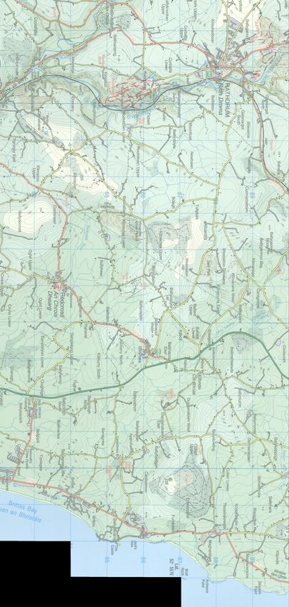
2.1 Site Location and Context
The application site comprises a former rock quarry and tied manufacturing facilities at Ballinclare Quarry
in Co. Wicklow, approximately 2.5km to the north-west of the small settlement of Kilbride and 2.5km
south of the village of Glenealy. The site location is indicated in Figure 1.
The overall Kilsaran land ownership area at Ballinclare Quarry extends to approximately 36 ha (89 acres),
while the prospective planning application site covers approximately 32.5ha (78.3 acres). The Applicant’s
landholding is shown edged blue in Figure 1, while the extent of the application area is shown edged red
on the same figure.
For the avoidance of doubt, any reference within this Planning Statement to ‘site’ or ‘application site’
should be taken construed to refer to the application area shown in Figure 1, while the wider landholding
(within the blue line boundary) is identified as ‘the overall site’ or ‘Ballinclare Quarry’.
The application site straddles two townlands, Ballinclare and Carrigmore, and extends across all of the
former quarry footprint and includes the former concrete / asphalt production area, a recently
constructed paved concrete block yard, established site buildings and infrastructure and a network of
settling ponds in the north-western corner. It excludes a compound / yard area leased to Wicklow County
Council in the north-western corner of the landholding, identified as its Carrigmore Depot. The existing
site layout is shown on a site survey / contour plan in Figure 2.
2.2 Site Description and Land Ownership
The existing quarry development at Ballinclare extends across approximately 24 hectares (c. 59.3 acres),
of which the existing quarry extraction area extends to c.9.3 hectares (c. 22.9 acres). Ground levels in the
vicinity of the quarry vary between 55mOD to 60mOD along the southern site boundary, close to the
L1157 Local Road and rise to 90mOD at the highest point along the northern boundary where the main
quarry face cuts into a rock slope which rises northwards. Typical levels along the northern quarry
boundary range from 50mOD to 70mOD.
Extraction across the quarry generally extended to a floor level of approximately 37mOD. At the time
extraction activity was suspended in 2016, the two existing quarry benches were being extended
westwards. As a result, the quarry floor is locally higher at the western end, where the first bench has
only been developed to a level of approximately 52mOD. The quarry floor is also locally deeper in the
central eastern area of the quarry area and extends to approximately 22mOD where a third bench had
been commenced. As a low point, this area effectively acts as the quarry sump at the current time.
The quarry is accessed via a 120m long surfaced entrance road leading off an existing junction with the
L1157 Local Road. The former readymix concrete batching plant and asphalt plant were located to the
south-east of the quarry holding, east of the access road, in an area where rock was previously excavated
to a relatively shallow depth (of between 5m and 10m).
Established ancillary facilities at the quarry include the main site office, a weighbridge and adjoining
weighbridge office, staff canteen and toilets, a wastewater treatment system, a wheelwash, a bunded
fuel storage area, a garage / workshop and a laboratory. It is proposed to retain all hardstanding areas
and site infrastructure for the duration of the on-site landfilling and waste recovery activities.
A concrete block yard which was built on foot of the recent (2016) planning permission is located to the
west of the site access road, as are a number of former farm buildings and the former storage yard. The
farm buildings comprise a stone barn and two concrete walled barns, all with corrugated tin roofs. A more
modern brick-built two-storey building is also present in this area.
Page 3Kilsaran Concrete – Ballinclare Quarry, Kilbride, Co. Wicklow
Inert Landfill and C&D Waste Recovery Facility SLR Ref No: 501.00036.00080
Planning Statement April 2021
2.3 Site Access
Traffic travelling to the application site principally travels to Junction 18 of the M11 Motorway between
Dublin and Wexford (beside the Beehive Inn) and travels south-west from there for approximately 3.8km
along the L1113 Local Road to Ballinclare Quarry. Traffic turns left (and east) at a T-junction and travels
for a further 0.6km along the L1157 local road to the entrance to Ballinclare Quarry.
Alternatively traffic travelling along the R772 Regional Road (the former N11 National Primary Road) can
turn off at the Tap Café / Restaurant at Kilbride and travel north-westwards for approximately 2km along
the L1157 local road to the entrance to Ballinclare Quarry.
Under the current planning permission for rock quarrying (Planning Ref. 14/2118), HGV’s travelling to and
from Ballinclare Quarry are directed to use a dedicated one-way haul route. HGV’s approaching the
quarry from M11 Junction 18 (at the Beehive Inn) travel along the L1113 Local Road, then turn left onto
the L1157 Local Road and to the junction with the existing quarry access road. Traffic departing the quarry
turns left and travels along the L1157, up to its junction with the R772 Regional Road, and from there
proceeds north (or south) to access the M11 Motorway and the National Road network.
As part of the pre-application consultations undertaken with Wicklow County Council (in accordance with
the Board direction issued on foot of the Section 37B referral), a walkover survey of the existing local road
network around the application site was undertaken and as assessment made of aspects such as road
geometry, structural integrity, traffic flows and travel speeds.
Based on these assessments and having regard to local traffic flow characteristics and the changes arising
after the M11 motorway opened in 2015, Wicklow County Council advised that it would be preferable to
revise the existing long established haul route to the quarry / application site so that HGVs would avoid
the L1113 Local Road and would instead travel the shorter distance to and from the R772 Regional Road,
in both directions along the L1157 Local Road.
In light of this feedback, this application proposes to route all HGV traffic to and from the proposed
integrated inert waste management facility at Ballinclare Quarry along the L1157 Local Road. It has also
made provision for a comprehensive road improvement scheme along the length of the L1157 leading up
to the application site, including road widening to 6.0m over most of the route length, with road
strengthening and repair overlay and road markings. Further details in respect of consultations with the
Roads Authority and the proposed road upgrade works to be undertaken in advance of soil / C&D waste
intake to the proposed facility, are provided in Chapter 14 (Traffic) of this EIAR.
Under the current proposal, the majority (>95%) of the HGVs travelling to the proposed inert waste
management facility from Dublin and North Wicklow will use the M11 Motorway, exiting at Junction 18
and joining the R772 southbound. After travelling south for approximately 4km, traffic heading for the
waste facility will turn right from the R772 and onto the L1157 at the ghost island junction near the Tap
Restaurant at Kilbride. The access junction to the existing quarry / application site is located along the
L1157, approximately 2km north-west of the R772 junction.
It is estimated that less than 5% of HGV traffic will arrive from the direction of Arklow and North Wexford.
This traffic will use the M11 Motorway, exiting at Junction 19 to turn onto the R772 Regional Road at Jack
Whites Pub. It will then travel north for approximately 5km and turn left, off the R772, and onto the L1157
and continue up to the application site.
Under the proposed revised haul route, all HGV traffic departing the site is required to turn left and follow
the upgraded L1157 back to the R772, and from there return to the motorway / national road network.
Page 4Kilsaran Concrete – Ballinclare Quarry, Kilbride, Co. Wicklow
Inert Landfill and C&D Waste Recovery Facility SLR Ref No: 501.00036.00080
Planning Statement April 2021
2.4 Current Land Use
There has been little activity at the application site following suspension of quarrying activities in 2016
following the discovery of small quantities of naturally occurring asbestos (NOA) in the diorite bedrock
being quarried at the time.
When it was operating, the quarry at Ballinclare was effectively worked dry, with very little inflow of
groundwater recorded into the quarry void. A sump located at the lowest point on the quarry floor
collected any surface water run-off as well as any minor inflows of groundwater from the quarry faces.
Water collecting in the sump was periodically pumped to water storage tanks for re-use in concrete
production on-site or for dust suppression.
Surplus water was pumped off-site via a series of settlement ponds to a drainage channel leading to the
Ballinclare Stream immediately beyond the north-western site boundary. Approximately 400m north and
downstream of the discharge point, the Ballinclare Stream flows into the Potters River.
Since extraction and production activities ceased in 2016, the floor of the quarry has been flooded with
surface water run-off and groundwater ingress. The volume of water in the quarry void at the present
time is estimated to be of the order of 270,000m3.
2.5 Surrounding Land Use
The area surrounding the application site at Ballinclare Quarry is typically rural in character and dominated
by forestry and undulating agricultural land. Ground level in the vicinity of the application site generally
lies between 60mOD and 70mOD. Ground levels rise in a south-westerly direction to c.270mOD at
Westaston Hill (approximately 2km SW) and in a northerly direction to 217mOD at Ballincooley Hill
(approximately 1.75km N).
Potters River flows approximately 450m beyond the northern boundary of the application site and then
turns south-eastwards and flows approximately 250m to the east of the landholding. Thereafter it
continues south-eastward and eventually discharges to the sea at Brittas Bay.
Residential property in the vicinity of the application site generally comprises farmsteads and isolated /
one off houses along the local road network. The nearest dwellings to the landholding boundary are those
located to the south, west and north of the site, along the local county road network.
There is another quarry located in Kilmacurra West, on the opposite side of the L1157 Local Road. It is
understood that this quarry is not currently active. The principal tourism / amenity facility in the vicinity
of the quarry is the Kilmacurragh Botanic Gardens, an outpost of the National Botanic Garden in Glasnevin,
Dublin, which is located just under 1km to the south-west of the site.
Details of natural features, established land-use and development surrounding the application site at
Ballinclare Quarry are shown on Figure 3.
2.6 Planning History
It is unclear when extraction activities first commenced at the application site, however it is known that
the use pre-dated 1964. As was required under Section 261 of the Planning and Development Act of 2000,
Ballinclare Quarry was registered by SM Morris with Wicklow County Council (WCC) on the 4th March 2005
(Quarry Ref. QY/4). Table 1 below provides an overview of the planning history of Ballinclare Quarry.
Page 5Kilsaran Concrete – Ballinclare Quarry, Kilbride, Co. Wicklow
Inert Landfill and C&D Waste Recovery Facility SLR Ref No: 501.00036.00080
Planning Statement April 2021
Table 1
Planning History Overview
Reg. Decision
Development Description Decision Type
Ref. Date
QY/4 S. 261 Quarry Registration Registration 2007
S261A/ S. 261A Quarry Review - WCC requested a planning Review 2006
QY/4 application and EIAR to regularise all elements of the
Quarry
07/45 Retention of existing stone quarry (13.414 hectares) Granted November
including extraction areas, processing areas, stockpiling 2007, subject
areas, stone crushing and screening plant, and; to 21
• Concrete products manufacturing plant; conditions
• Macadam and asphalt manufacturing plant;
• Waste recovery facility (as per Waste Permit
ESS/15/8/12);
• Carparking areas;
• Ancillary buildings including offices, toilets, laboratory,
maintenance workshop, control towers and cabins,
aggregate screening and aggregate storage buildings,
electricity substations and ancillary buildings (total
2,088.28 sq. metres);
• Septic tanks,
• weighbridge,
• truck wheelwash bay,
• floodlighting,
• oil and fuel storage tanks and water storage tanks.
• Proposed increase of stone extraction depth below the
level of existing quarry floor to a level of 25.00 metres
above sea level within existing quarry (6.634 hectares),
and;
• Proposed extension of existing quarry towards the
west (10.605 hectares) to a level of 25.00 metres
above sea level.
14/2118 Permission for continued use of the permitted Granted 8/2/2016,
development under Ref. 07/45 for 25 years; subject to 23
• Extension to the quarry floor level of +1mOD over an conditions
extraction area of 16.5 hectares;
• Permission for a concrete block manufacturing plant
and concrete block manufacturing yard; Aggregate
washing plant;
• Replacement of existing septic tank; Increase in
product output from 70 to 150 loads per day;
• All associated site works.
Page 6Kilsaran Concrete – Ballinclare Quarry, Kilbride, Co. Wicklow
Inert Landfill and C&D Waste Recovery Facility SLR Ref No: 501.00036.00080
Planning Statement April 2021
2.6.1 Section 261 Quarry Registration (Quarry Ref. QY/4)
SM Morris Ltd. registered the quarry at Ballinclare with Wicklow County Council in accordance with the
requirements of Section 261 of the Planning & Development Act, 2000 (Quarry Ref. QY/4) on the 4th March
2005. The area registered at the time was approximately 13.4 hectares / 33.1 acres.
The planning authority registered the quarry and in accordance with Section 261 (7) of the Planning and
Development Act 2000 directed that “a planning application and an environmental impact statement in
respect of the quarry within 6 months of the date of service of this notice, or such other period as may be
agreed with the Planning Authority” as the extracted area was greater than 5 hectares and operations on
site commenced prior to 1st October 1964 and therefore would be likely to have significant effects on the
environment.
This direction ultimately begat planning application 07/45 referenced in Table 1 above.
2.6.2 Section 261A Determination (Quarry Ref. S261A/QY/4)
Following a European Court Judgement against Ireland in 2008, which identified shortcomings in the
State’s transposition of the EU Environmental Impact Assessment (EIA) and Habitats Directives into Irish
law, amending legislation (‘Section 261A’) was introduced via the Planning and Development
(Amendment) Act of 2010 to ensure that the regulation and control of quarries had due regard to the
requirements of the two Directives.
A review of the planning status of Ballinclare Quarry was undertaken by Wicklow County Council in 2012,
in accordance with the requirements of Section 261A. The Council determined in August 2012 that the
quarry at Ballinclare and Carrigmore, Kilbride, Co. Wicklow (S261A/QY4) was in compliance with the two
Directives and that no further regulatory controls were required at the quarry.
2.6.3 Planning History
In addition to the Section 261/ Section 261A processes listed above, there have been a number of planning
applications made in respect of the application site. The following is a list of previously approved
development at the site.
Planning Permission (Ref. 93/369)
Within the quarry area, permission for a macadam / asphalt plant was granted in January 1994 under WCC
Ref. 93/369 and An Bord Pleanála Ref. PL 27.092182, subject to 10 No. conditions. This permission in
relation to the macadam / asphalt plant was superseded by permission Ref. 07/45.
Planning Permission (Ref. 95/2380)
Located within the quarry area, permission for a concrete production manufacturing (readymix) plant was
granted in February 1997 under WCC Ref. 95/2380 and An Bord Pleanála Ref. PL 27.099861, subject to 13
No conditions. This permission in relation to the concrete manufacturing plant was superseded by
permission Ref. 07/45.
Planning Permission (Ref. 07/45)
On foot of the Section 261 direction by Wicklow County Council of requesting the submission of a planning
application and an environmental impact statement (EIS), an application for continued operation of the
existing quarry and for further development thereof was submitted to Wicklow County Council on 12th
January 2007.
S.M. Morris, the quarry operator at the time, had identified additional stone reserves outside the Section
261 registered area and the planning application provided for extension of the quarry into these lands to
the west.
The full details of the planning permission applied for was:
Page 7Kilsaran Concrete – Ballinclare Quarry, Kilbride, Co. Wicklow
Inert Landfill and C&D Waste Recovery Facility SLR Ref No: 501.00036.00080
Planning Statement April 2021
• Retention of existing stone quarry (13.414 hectares) including extraction areas, processing areas,
stockpiling areas, stone crushing and screening plant, and;
o Concrete products manufacturing plant;
o Macadam and asphalt manufacturing plant;
o Waste recovery facility (as per Waste Permit ESS/15/8/12);
o Carparking areas;
o Ancillary buildings including offices, toilets, laboratory, maintenance workshop, control
towers and cabins, aggregate screening and aggregate storage buildings, electricity
substations and ancillary buildings (total 2,088.28 sq. metres);
o Septic tanks, weighbridge, truck wheelwash bay, floodlighting, oil and fuel storage tanks
and water storage tanks.
• Proposed increase of stone extraction depth below the level of existing quarry floor to a level of
25.00 metres above sea level within existing quarry (6.634 hectares), and;
• Proposed extension of existing quarry towards the west (10.605 hectares) to a level of 25.00
metres above sea level.
Wicklow County Council granted permission for the development on the 4th December 2007 subject to 39
conditions for a 20 year period, expiring on 3rd December 2027.
Planning Permission (Ref. 14/2118)
Following its acquisition of the quarry, the above planning permission was lodged by Kilsaran on the 4th
December 2014. The development on an application site of 36 hectares, sought a 25 year permission
comprising:
• Continued use of the permitted development under Ref. 07/45 for 25 years.
• Extension to the quarry floor level of +1mOD over an extraction area of 16.5 hectares.
• Permission for a concrete block manufacturing plant and concrete block manufacturing yard
• Aggregate washing plant.
• Replacement of existing septic tank.
• Increase in product output from 70 to 150 loads per day.
• All associated site works.
This application was submitted with an EIS and NIS Screening Report at the request of Wicklow County
Council and was granted on 8th February 2016 subject to 23 Conditions.
2.7 Planning Consultation
Following the quarry closure in 2016, SLR Consulting Ireland was appointed by Kilsaran to examine the
feasibility of a range of backfilling and restoration options at the quarry, having regard to the availability
of materials, available intake capacity at other waste facilities, market entry and establishment costs and
potential water treatment costs.
Arising out of this review, Kilsaran elected to backfill and restore the quarry as an inert waste landfill with
the installation of a clay lining system at its base and sides in order to protect groundwater in the
surrounding aquifer. On completion of backfilling to former / surrounding ground levels, the resultant
landform will be restored to long-term grassland / scrub habitat, similar to that which existed prior to
quarrying.
Page 8Kilsaran Concrete – Ballinclare Quarry, Kilbride, Co. Wicklow
Inert Landfill and C&D Waste Recovery Facility SLR Ref No: 501.00036.00080
Planning Statement April 2021
An initial pre-planning consultation meeting was held between officials of Wicklow County Council and
representatives of Kilsaran Concrete and SLR Consulting Ireland on 7th February 2019 at the offices of
Wicklow County Council in Wicklow Town. Staff from the roads, water and environment services
departments of Wicklow County Council were also in attendance.
On 21st June 2019, Kilsaran submitted a request to An Bord Pleanála (ABP, or ‘the Board’) under Section
37B of the Planning and Development Act 2000, as amended, to enter into pre-application discussions
with respect to the proposed inert landfill and C&D waste management activities at Ballinclare Quarry,
specifically to establish whether or not the proposed waste facility should be classified as Strategic
infrastructure Development (SID) under the Planning and Development Act of 2000 (as amended).
The Board’s representatives met with the Kilsaran on 13th November 2019, and a formal request was
made to close the pre-application consultation process by letter on 20th December 2019.
Having reviewed the matter, the Board concluded that the proposed development satisfied the statutory
criteria for designation as Strategic Infrastructure and, as such, issued a direction to Kilsaran that a
planning application should be submitted directly to it (the Board) for consideration.
In arriving at its decision to classify the proposed development at Ballinclare Quarry as strategic
infrastructure, the Board had regard to
(i) the size and scale of the proposed inert landfill and C&D waste recovery facility;
(ii) the fact that it would meet a previously identified need for additional waste management
capacity for management of inert soil and stone waste within the Eastern / Midland waste
region; and
(iii) support the attainment of national and regional planning objectives to increase the recycling
of construction and demolition waste and in so doing, build a circular economy and promote
the long-term sustainable use of resources.
Attached to the Board’s decision was a list of prescribed bodies to be notified of the intended
application and consulted in advance of its submitting to the Board. The bodies list by the Board are
set out in Table 2 below.
Table 2
Prescribed Bodies Listed by the Board
Prescribed Bodies
Wicklow County Council Minister of Culture, Heritage and the
Gaeltacht
Minister for Communications, Marine and Geological Survey of Ireland
Natural Resources
Inland Fisheries Ireland Environmental Protection Agency
Bord Fáilte An Taisce
Health Service Executive Transport Infrastructure Ireland
Health and Safety Authority Eastern-Midlands Waste Regional Authority
Irish Water
Page 9Kilsaran Concrete – Ballinclare Quarry, Kilbride, Co. Wicklow
Inert Landfill and C&D Waste Recovery Facility SLR Ref No: 501.00036.00080
Planning Statement April 2021
It is recognised that early consultation can help in the identification of potentially significant
development issues and allows these issues to be considered at the earliest possible opportunity. This
then provides the best opportunity for considering design alternatives (where available) and for
implementing measures to avoid, prevent, reduce or, if possible, offset any identified significant
adverse effects on the surrounding environment (including a Natura 2000 site).
In addition to consultation with prescribed bodies therefore, consultations were also initiated with
non-statutory consultees, principally local residents and the general public with a likely interest in the
planned development at Ballinclare Quarry. These consultations were commenced on 13th October
2020 and ended on 14th December 2020. The objective of this consultation exercise was,
(i) To provide the public with information on the proposed development and to it with an
opportunity to raise queries and discuss the proposed development and raise issues with
Kilsaran representatives and their Project Team; and
(ii) To engage with, and seek the assistance of, the public and prescribed bodies in considering the
environmental issues to be assessed in the EIAR and NIS, to be prepared and submitted with
the project’s application for development consent.
Full details of the pre-planning consultations undertaken in respect of this development are presented in
a Pre-Planning Consultation Report which forms part of the submission documentation provided to the
Board in support of this planning application. The report presents details regarding the consultation
activities and an overview / response to the feedback provided.
Additional consultations, both formal and informal, were also undertaken where required by specialist
contributors to the Environmental Impact Assessment Report in preparing their Chapters. Details of such
consultations are provided in the EIAR, together with details of reviews undertaken of relevant archives
and documentation held by state agencies and organisations. There was also significant consultation
between the specialist EIAR contributors on interactions between environmental media and receptors.
2.8 National and Local Designations
2.8.1 Natura 2000, NHA and pNHA Sites
There are no designated nature conservation sites (Special Area of Conservation (SAC), Special Protection
Area (SPA), Natural Heritage Area (NHA) or proposed Natural Heritage area (pNHA) within or adjacent to
the application site. The closest such sites are the Deputy’s Pass Nature Reserve SAC (Site Code 000717)
and the Glenealy Woods pNHA (Site Code 001756), which, at their closest point are located approximately
1.6 km and 1.1km to the north-west of the application site respectively. The next closest site is the
Buckroney-Brittas Dunes and Fen SAC (Site Code 000729) some 7 km southeast of the application site.
2.8.2 Recorded Monuments
There are no recorded monuments located within or immediately adjacent to the application site. The
nearest recorded monument is located approximately 300m to the west, in a nearby agricultural field and
is identified as a church, holy well and graveyard (Ref. WI030-014). While there is now no physical trace
of it, the local 25 inch historical map identifies it as the site of Kilmanoge Church.
Thereafter, the nearest recorded monument is a ringfort (Ref. WI031-004) located approximately 500m
to the east north-east (ENE) at its closest point. Elsewhere, a number of archaeological sites, described
as burnt mounds, were identified in recent years during pre-construction investigations along the M11
Motorway corridor to the east of the site.
Page 10Kilsaran Concrete – Ballinclare Quarry, Kilbride, Co. Wicklow
Inert Landfill and C&D Waste Recovery Facility SLR Ref No: 501.00036.00080
Planning Statement April 2021
2.8.3 Built Heritage
There are no structures identified on the National Inventory of Architectural Heritage within or in the
immediate vicinity of the application site. There nearest protected structures in the local area are,
(i) Westaston Demesne Country House (Structure No. 30-18) is a late-17th Century house which now
in ruins, located approximately 0.9km to the south-west of the application area.
(ii) Coolacork Country House (Structure No. 31-06), a late 18th Century house located approximately
0.95km to the north-east.
There is a further cluster of protected structures located around the townland of Ballymurrin Lower,
approximately 1.5km to the east of the application site (and to the east of the M11 Motorway).
2.8.4 Landscape
According to the current Wicklow County Development Plan 2016-2022, the application site is located
within a landscape sensitivity area identified as a “Corridor Area”. This area is described as “comprising
lands either side of the main transport routes within the County, the N11 and N81”. The landscape around
the site is further categorised as being of ‘medium vulnerability’. At the present time however, almost all
external views into the application site are screened by existing dense roadside vegetation around the
site boundary and by further intervening vegetation within the site itself.
2.8.5 Geological Heritage
The online Irish Geological Heritage map indicates that Kilmacurra Quarry on the western side of the
L1157 Local Road is designated a County Geological Site (CGS). The quarry, which is currently partially
flooded is located approximately 700m to the south west of the application site. There are no other
designated geological sites in the immediate vicinity.
Page 11Kilsaran Concrete – Ballinclare Quarry, Kilbride, Co. Wicklow
Inert Landfill and C&D Waste Recovery Facility SLR Ref No: 501.00036.00080
Planning Statement April 2021
PROPOSED DEVELOPMENT
The proposed development at Ballinclare Quarry provides for progressive backfilling and restoration of
the existing quarry void, previously approved under Refs. 93/369, 95/2380, 07/45, 14/2118 and QY/4, by
way of establishment and operation of an inert waste landfill facility.
The inert landfill will principally provide for the importation, disposal and/or recovery of inert construction
waste generated by construction activities in Counties Wicklow, Dublin and Wexford. It is proposed to
backfill the existing quarry void at the application site to original / surrounding ground level and in so
doing re-establish the landform which existed prior to quarrying. The landfilling and restoration activities
will both be undertaken on an ongoing, progressive basis.
As part of the proposed development, suitable uncontaminated, undisturbed, natural soil waste and/or
soil by-product (i.e. non-waste) which conforms to an engineering specification will be imported for re-
use in the construction of the basal and side clay liners required for the inert landfill. Some
uncontaminated topsoil waste and/or topsoil by-product will also be imported for use in the final
restoration of the backfilled landform. Topsoil will be temporarily stockpiled at the landfill facility as
required, pending its re-use as cover material.
The proposed development also provides for the establishment and operation of a construction and
demolition (C&D) waste recovery facility across the footprint of the existing paved concrete blockyard.
The principal wastes to be recycled at this facility will include concrete (ready-mixed, reinforced, blocks
and/or pavement slabs), bricks and bituminous mixtures (hardened asphalt returns and road planings).
Provision is also for the installation of a soil washing plant at the former concrete / asphalt yard in the
south-eastern corner of the application site to recover sand and gravel / aggregate from more granular
soil intake and claybound C&D intake.
The proposed site layout when all proposed waste management facilities are established and fully
operational is shown in Figure 4.
In summary, the proposed development will comprise the following:
• Backfilling of the existing void at Ballinclare Quarry to original ground level by developing and
operating an inert waste landfill facility with a total intake capacity of approximately 6,165,000
tonnes of inert soil and stone waste and (non-waste) soil and stone by-product and its progressive
restoration to long-term scrub / grassland habitat thereafter;
• Continued use of existing site infrastructure and services including, site / weighbridge office, staff
welfare facilities, wastewater treatment system, outbound weighbridge, garage / workshop,
wheelwash, hardstand areas, fuel and water storage tanks to service the proposed development;
• Installation of a new weighbridge along the inbound lane of the quarry access road;
• Decommissioning of any remaining fixed plant and infrastructure associated with former rock
extraction activities or with aggregate, concrete and asphalt production activities at the
application site;
• Off-site removal of any materials or bulky wastes associated with the former quarrying and
production activities;
• Construction of an industrial shed (portal frame structure) at the paved blockyard area to house
crushing and screening equipment and to process / recycle inert C&D waste (principally concrete,
bricks, ceramics and solid bituminous waste mixtures);
• Use of any external paved area surrounding the C&D waste processing shed as a hardstanding
area for the external handling and storage of both unprocessed and processed C&D wastes;
Page 12Kilsaran Concrete – Ballinclare Quarry, Kilbride, Co. Wicklow
Inert Landfill and C&D Waste Recovery Facility SLR Ref No: 501.00036.00080
Planning Statement April 2021
• Separation of any intermixed C&D wastes (principally metal, timber, PVC pipes and plastic) prior
to its removal off-site to authorised waste disposal or recovery facilities;
• Installation and operation of a soil washing plant at the former concrete / asphalt production yard
to recover sand and gravel and secondary aggregates from soil waste for subsequent use in the
production of construction materials
• Construction of an on-site (passive) wetland treatment system and attendant drainage
infrastructure to treat surface water run-off / groundwater collecting in the sump / floor of the
quarry area during landfilling operations and any surface water run-off from the C&D waste
recovery area prior to its discharge off-site;
• Re-use of an existing storage shed as a dedicated waste inspection and quarantine facility to
inspect and store suspect waste consignments as required;
• Upgrading and ongoing maintenance of established internal haul roads across the application site;
• Temporary stockpiling of topsoil pending re-use as cover material for phased and/or final
restoration of the inert landfill / backfilled quarry; and
• Environmental monitoring of noise, dust, surface water and groundwater for the duration of the
landfilling and restoration works and C&D waste recovery activities, and for a short period
thereafter.
3.1 Site Preparation / Establishment Works
Prior to commencement of the backfilling and recovery activities at the application site, the following site
preparation works will be required:
• Securing existing site perimeter with additional fencing / planting as required;
• Dewatering of the quarry void prior to any basal lining / landfilling activities;
• Cutting and mulching of any existing scrub and vegetation across the proposed development
footprint and off-site removal to authorised waste facilities (undertaken in phases prior to
commencement of works in designated areas);
• Decommissioning and dismantling of any other legacy infrastructure from prior development (eg.
production plant, metal, WEEE, additives etc.) and removal off-site to other Kilsaran production
sites or authorised waste facilities (as case may be);
• Installation of new weighbridge, reconfiguration of site / weighbridge office and re-establishment
of staff welfare facilities and wheelwash facility;
• Minor repair / maintenance / upgrading works to existing bunded fuel storage area and concrete
slab with sub-surface drainage to hydrocarbon interceptor and soakaway area;
• (Re-)commissioning of previously approved septic tank and wastewater treatment facilities;
• Excavation, clearance and levelling of existing ground at proposed wetland area and construction
of the wetland treatment area;
• Construction of the proposed concrete portal frame structure (open on two sides) at the C&D
waste recovery facility;
• Construction / installation of surface water drainage infrastructure between the landfill, recovery
shed and C&D waste recovery area and the proposed wetland area;
• Installation and commissioning of the soil washing plant in the former concrete / asphalt yard in
the south-eastern corner of the application site;
• Upgrading of internal access roads leading to the waste recovery facility and wetland area;
• Establishment of environmental control and monitoring infrastructure.
Page 13Kilsaran Concrete – Ballinclare Quarry, Kilbride, Co. Wicklow
Inert Landfill and C&D Waste Recovery Facility SLR Ref No: 501.00036.00080
Planning Statement April 2021
It is likely that some or all of the proposed site establishment / pre-commencement works outlined above
will be subject to prior agreement and oversight of the EPA, in accordance with standard conditions
attaching to any EPA waste licence issued in respect of the proposed waste activities.
3.2 Proposed C&D Waste Recovery Shed
It is proposed to construct a large, roofed portal frame structure, open on two sides at the existing paved
concrete (former blockyard) area to the west of the site access road, as indicated in the site layout plan
in Figure 4. All future C&D waste processing, crushing and recovery activities will take place within this
structure in order to reduce noise and fugitive dust emissions.
The proposed structure will be of portal frame steel construction and will have a plan footprint area of
approximately 42m long by 36m wide, with the long axis orientated in an east-west direction. The
structure height will vary from 10m at the haunch (top of sidewall column supports) to a maximum of
12m at the roof apex.
It is envisaged that once C&D waste recovery infrastructure is established at Ballinclare Quarry, mobile
crushing plant will be brought to the facility periodically (when sufficient quantities of recyclable material
has accumulated in external stockpiles).
During recycling campaigns, the crushing plant will be set up on the paved concrete floor within the
proposed open-sided waste recovery shed. The recyclable C&D waste will be transferred from external
stockpiles to the mobile crusher within the shed. Once crushed and processed, the recycled material
(secondary aggregates) will be moved out of the shed to external stockpiles pending testing, sale and
export off site.
Recycling activities will produce a particulate, granular aggregate conforming to standard industry
specifications and End-of-Waste criteria set by the EPA and it is envisaged that they will most likely be re-
used in road construction or for concrete production.
Surface water run-off from the shed roof and the existing paved concrete slab will be collected by surface
water drains and/or channels around the perimeter of the slab and transferred across to the proposed
on-site (passive) wetland treatment system to remove any potential sediment and treat any potential
contaminants in the run-off.
3.3 Soil Washing / Aggregate Recovery Plant
At the outset of the project, a soil washing plant will be set up and commissioned in the former concrete
/ asphalt production yard in the south-eastern corner of the application site. This plant will effectively
recover sand and gravel aggregate from selected, more granular soil waste and claybound C&D waste
imported to the facility. The proposed location and configuration of the soil screening / aggregate
recovery plant is shown in the site layout plan in Figure 4.
The soil washing plant comprises a loading hopper, a number of soil screens in series with connecting
conveyor systems, a primary wastewater treatment tank (thickener), a buffer tank holding sludge and
recycled water, an elevated plate press and filter cake discharge area.
There will be no surface water / groundwater emissions or off-site discharges arising from the proposed
soil washing and aggregate recovery activities as all process water will be re-circulated within a closed
loop system. As such, there is therefore no requirement to make provision for treatment for any process
water associated with the activity. It is likely that occasional water top-ups will be required for the plant
and if so, these will be provided from the existing water storage tanks.
All elements of the washing plant are either mobile or largely self-standing and can be readily lifted into
place, assembled in-situ and relocated / removed as required. Most of the plant will be supported on the
existing concrete slab across the former production yard or on thickened foundations where required.
Page 14You can also read