Polish Institute of Meteorology and Water Management - National Research Institute - Who we are. Our services.
←
→
Page content transcription
If your browser does not render page correctly, please read the page content below
Polish Institute of Meteorology and Water Management
- National Research Institute
Who we are. Our services.
Polish Institute of Meteorology and Water Management - National Research Institute

IMGW-PIB is a Poland national weather service. We provide weather
and climate-related services to the Armed Forces, government
departments, the public, civil aviation, shipping, industry, agriculture
and commerce.

Since 1919, we have been forecasting weather, conducting analyzes and
research.

Weather and climate is one of the most important topics in the modern
world.                          Tytuł prezentacji z tutaj
We are an Institute gathering high-class professionals and we have the
necessary infrastructure to work on it.
National Hydrological and Meteorological Service
– changes since 2018

• Change of the subordinate ministry – Ministry of Maritime
Economy and Inland Navigation

• Change in financing IMGW-PIB

• Liquidation of branches

• Reduction of employment

• New business approach and products
                                    Tytuł prezentacji z tutaj
• New partnerships initiative

• New communications strategy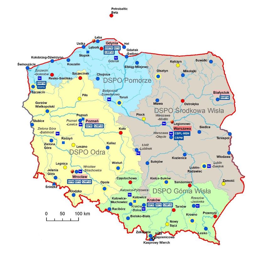
Department’s of Measuring and Observation Service

                                 Tytuł prezentacji z tutaj
Department of Measurement and Observation Service - Pomerania

                                Tytuł prezentacji z tutaj
Department of Measurement and Observation Service – Upper Vistula

                                 Tytuł prezentacji z tutaj
Department of Measurement and Observation Service – Middle Vistula

                                 Tytuł prezentacji z tutaj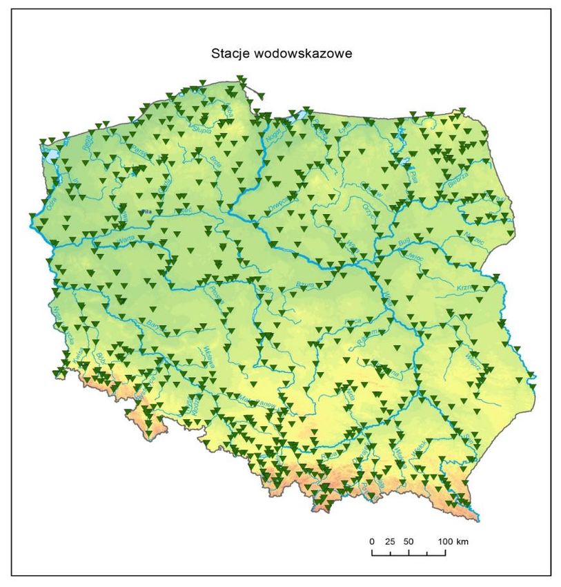
Department of Measurement and Observation Service – Oder

                                Tytuł prezentacji z tutaj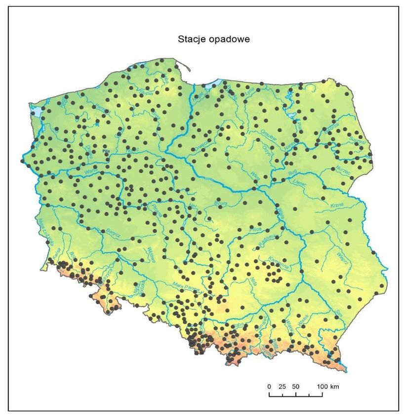
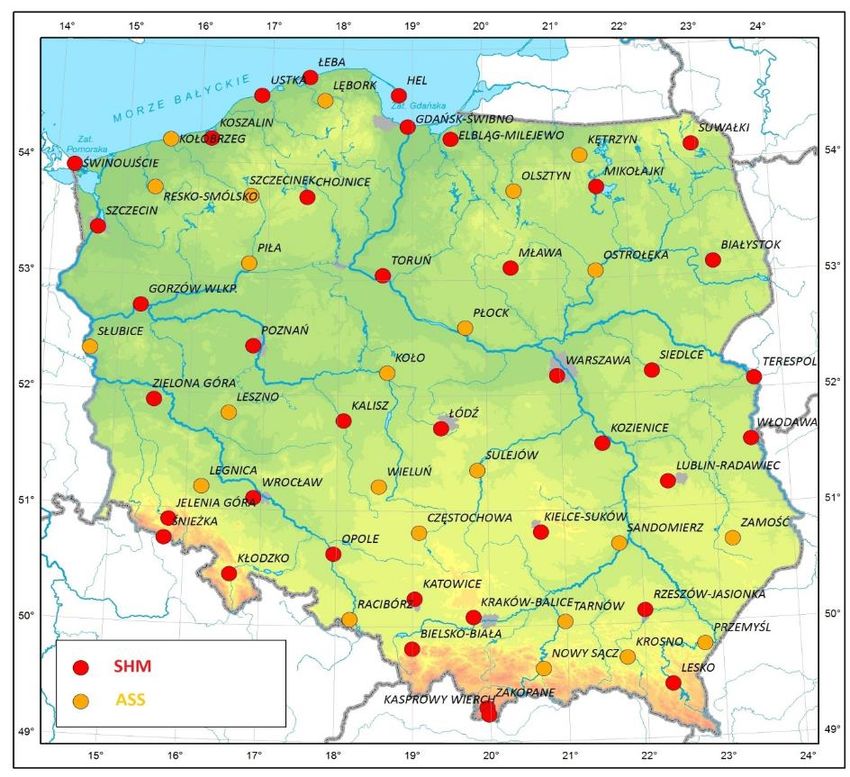
Synoptic stations coverage

SHM
Hydrological-meteorological stations

ASS
Automatic synoptic stations     Tytuł prezentacji z tutaj
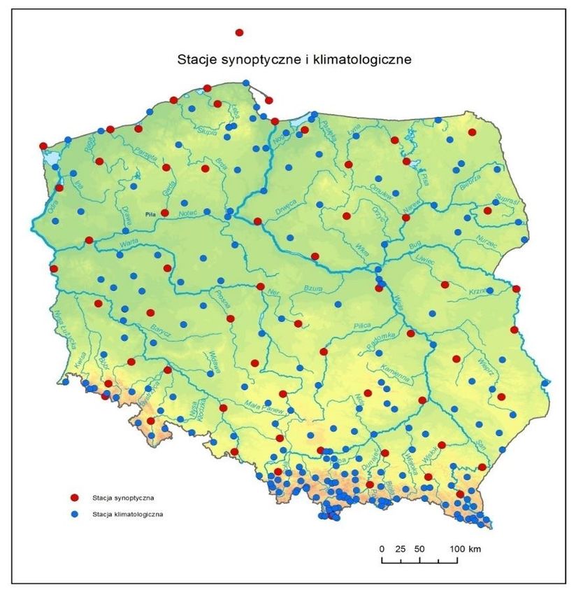
Synoptic and climatological stations

267 locations including 182 locations with
telemetric measurements*

Main measured parameters:
• Rainfall
• Wind direction and strenght
• Air temperature
• Ground temperature
• Insolation
• Visibility
• Snow cover
                                       Tytuł prezentacji z tutaj
Synoptic stations
Climate stations
* January 1st, 2019
Rainfall stations
633 locations including 247 with telemetric
measurements*
Main measured parameters: Rainfall
Rainfall stations
* January 1st, 2019
Tytuł prezentacji z tutajGauge stations
863 gauge locations including 610 locations
with telemetric measurements*
Main measured parameters:
• Water level
• Temperature
• Discharge
• Ice cover
• Overgrowing
Tytuł prezentacji z tutaj
Gauge stations
* January 1st, 2019Limnological measurements 13 water balance lakes – chosen lakes with limnology measurements (temperature, aeration, transparency) 4 base lakes – water balance lakes with evaporation raft. 42 gauge locations on lakes and rivers and special network of 11 piezometers. Main measured parameters: • Water level • Temperature • Ice cover • Discharge • Underground water level Limnological measurements * January 1st, 2019
Evapotranspiration measurements

Evaporation pan (20m_ type and GGI3000 type)
21 locations on synoptic and climatological
stations in main Polish climatic regions

Evaporation raft
4 locations on main Polish lakelands
Limnological measurements / Evapotranspiration measurements
Aerological measurements

3 Aerological stations:
• Łeba (North Poland)
• Legionowo (Central Poland)
• Wrocław (West-South Poland)

Radiosonde RS41SG (Vaisala) attached to a hydrogen
balloon

2.147 measurements performed in 2015

Measurement average height: 31,5 km
Actinometrical network

Network of actinometrical: 24 stations

Measurement of:
• total radiation
• scattered radiation
• reflected radiation
• radiation balance
• photosynthetic active radiation (PAR)
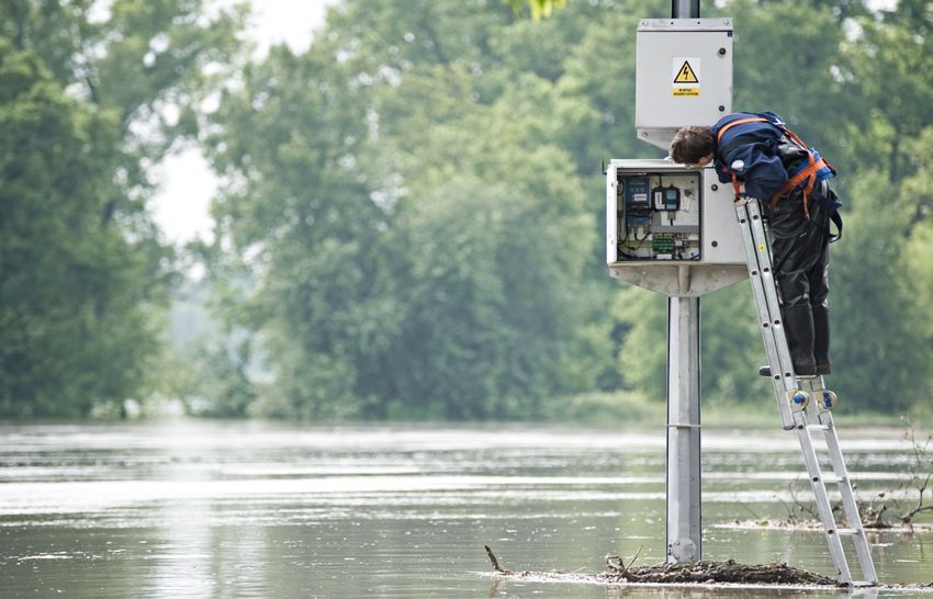
Service of Measurement Systems

Technical supervision over all components of measurement systems is
a key task of regional Departments of Measurement System Services
as a part of Department of Measurement and Observation Service and
the Department of Measurement Systems in Warsaw.

We analyze: hydrology, weather, actinometric, airport AWOS systems

The Departments of Measurement Systems Service provide full technical
facilities for services provided by IMGW-PIB like:
• installation and configuration of new systems
• current service
• troubleshooting
• system integration
• supervision of the telemetry system

In many cases, including the service of airport systems, service teams
operate in a 24-hour mode.
POLRAD. The weather radar network

The weather radar network:
• average height of radar tower: 30 m
• tower construction: concrete or steel
• communications systems: hard link

Number of radar types:
• 3 Meteor 1500C (klistron transmitter): 5650 MHz*
• 3 Meteor 500C (magnetron transmitter): 5660 MHz*
• 2 Meteor 1600DPC (klystron transmitter): 5650 MHz*

All are doppler radars and 3 are Dual-pol

Radar sites located:
• outside urban areas
• on the top of the hills
• close to airports
* operating frequency
PERUN. Lightening detection system

Network structure*

• 8 stations – TLS200 type
• 5 stations – SAFIR3000 type
• Localisation accuracy – less than 1km
• Detection efficiency – more than 90 proc.
* after modernisation 2010-2015
CMFS – Centre of Meteorological Forecasting Service

Meteorological Forecasting Offices (BPM):
• Central Meteorological Forecasting Office Warsaw
• Meteorological Marine Forecasting Office Gdynia
• BPM offices: Białystok, Poznań, Wrocław, Cracow

Numerical Forecasting Departments:
• COSMO
• ALADIN
• Nowcasting Unit

Team of Specialized Forecasts:
• biometeorological forecasts
• long-term forecasts
• agrometeorological service
Meteorological forecasts for hydrological protection

• Package text forecasts and warnings

• Forecasts of average and maximum
precipitation on catchments

• Rainfall forecasts for subregions
Meteorological forecasts for hydrological protection

Conducted for the following parts of waters:
• West Baltic
• Southern Baltic
• South-East Baltic
• Central Baltic
• North Baltic
• Polish coastal zone
• Pomeranian Bay
• Central Coast
• Gulf of Gdansk
• Szczecin Gulf and ports: Szczecin, Świnoujscie
• Vistula Lagoon
The scope of meteorological protection – a forecast of convective phenomena

From May to September, the special position in CBPM
– forecaster responsible for convective weather phenomena

Realization - a team of forecasters after special training
(CBPM + BPM in Cracow)

Publication - www.pogodynka.pl – possible distribution
to customers on request
The scope of meteorological protection – a forecast of convective phenomena

From May to September, the special
position in CBPM – forecaster
responsible for convective weather
phenomena

Realization – a team of forecasters after
special training (CBPM + BPM in Cracow)

Publication on www.pogodynka.pl
– distribution to customers
on request, too.
The scope of meteorological protection - specialized forecasts

• Biometeorological

• Agro

• Phenological

• Long-term
Numerical Forecasting

ALADIN
In operational mode maintains, develops and visualizes a numerical
meteorological model based on the operation of a cascade of models
from the ALADIN - ALARO - AROME family.

COSMO
In the operational mode maintains, develops and visualizes the
mesoscale meteorological model COSMO as an effective product
of the Institute's cooperation within the framework of the COSMO
mesoscale consortium (Consortium for Small ScaleModelling).

NOWCASTING Unit
Development of newcasting forecasts (ultra-short-term) based
on IMGW-PIB’s models with high temporal and spatial resolution,
complementing mesoscale numerical predictions by analyzing
high-resolution temporal and spatial data and using newcasting
technologies.
COSMO. Numerical Forecasting

Maintaining the COSMO model in constant operational readiness:
• supervision over the operation of the model and removal of failures
• implementation of new versions of the model
• implementation of postprocessing and data assimilation tools
• control of input and output data acquisition

Preparing and delivering products from the COSMO model:
• production of standard products for PSHM and external customers
• preparation and production of dedicated products, including those for
• commercial purposes
• maintaining the internal presentation of results – cosmo.imgw.ad

Quality control and verification of results:
• implementation of new tools and verification methods
• conducting analyzes of current results and historical forecasts

Cooperation within the COSMO consortium resulting from consortium agreements:
• co-organization and participation in cyclical meetings of member countries of the
consortium
• participation in the management structures of the consortium
• work in working groups, implementation of projects and priority tasks
COSMO. Current operating productions.

Production lines of COSMO models:
• cycle of data analysis and assimilation (CAAD) in 7 km resolution using data
from the global ICON (DWD) model
• COSMO model with 7 km grid resolution of with initial and boundary data from
the global ICON model (DWD) and assimilation from the CAAD system, forecast
for 78 hours
• COSMO model with 14 km grid resolution without assimilation cycle with initial
and boundary data from IOCN model (DWD), forecast for 78 hours
• COSMO model with 2.8 km grid resolution, with input data from the COSMO
model 7 km, forecasts for 48 hours
• beam forecasting system with the COSMO model with a resolution of 2.8 km
consisting of 20 elements of the beam and a forecast for 36 hours
• post-processing to the appropriate strings

Other systems operating in operating mode:
• wavelet model WW3
• RIOT (Ring of Threats) pollution transport system
COSMO. Research and implementation works.

Pre-operational production lines in 2019:
• RUC (Rapid Update Cycle), system run at a frequency of 30 minutes and a
forecast of 2 hours for the needs of aviation (VENTO), newcasting and flash
flood forecasts
• COSMO-EULAG - version of the model with a new dynamic core that allows
very high resolution forecasts (less than 1km)
• COSMO_v505 - the model in the latest official version 5.05 at a resolution of
2.8 km
• ICON-LAM – version of the ICON (DWD) model for local predictions, this
model is to replace in the consortium the currently developed versions of the
COSMO model from 2022

Main directions of research and development:
• issues of meteorology and climate change
• prediction of extreme weather phenomena
• methodology for numerical modeling
• basic research on the dynamics and physics of atmospheric processes

Implemented in 2019: statutory projects of the DS • projects financed from the
National Research Centre and Polish Research FoundationP funds • projects
and COSMO priority tasks • COST shares.
ALADIN. Numerical Forecasting

Participation in the works of the ALADIN
consortium:

• development of cloud microphisics in the
ALARO model

• research on numerical forecasts at the
boundary layer

• participation in the work on data assimilation

• development of the numerical prediction
verification system
ALADIN. Operational and research activities.

Operational forecasts:
• model ALARO (in red) with a spatial resolution of 4 km
• 60 vertical levels, forecast horizon 66 hours model AROME
(in blue) with a spatial resolution of 2 km
• 60 vertical levels, a forecast horizon of 30 hours models
operationally run 4 times a day

Research projects
• sub-kilometer numerical weather forecasts
• usage of artificial intelligence in weather forecasts
• usage of unmanned aerial vehicles as an additional
measurement tools at IMGW-PIB
ALADIN. Numerical forecasts verification.

Numerical forecasts verification of Aladin:

• system HARP – Hirlam-Aladin R Package for
verification

• verification of models used in IMGW-PIB

• point-to-point verification methods and spatial
verification
(SAL and fuzzy methods)
NOWCASTING Unit. Precipitation estimation.

• Quality control of rain gauge data (gau_qc_int)

• Weather radar data quality control
(RADVOL-QC system)

• Compositing of radar data based on quality
information (RadComposite)

• Multi-source precipitation estimation using quality
information and conditional merging RainGRS
system: rain gauges (G), radars (S) and
Meteosat (S)
NOWCASTING Unit. Nowcasting.

Precipitation nowcasting
SCENE model – lead time: 2h

Nowcasting of other meteorological fields
temperature, humidity, wind, pressure, etc.
(INCA-PL2 model) – lead time: 8h
NOWCASTING Unit. Other activities.

Other activities of Nowcasting Unit
• Estimation of surface precipitation type (SPT model):
snow, sleet, freezing rain, rain, probability of hail
• Probabilistic data (estimates and nowcasts)
generator (PROB): probability of exceeding

All the systems and models are parts
of the SEiNO system:
• spatial resolution: 1 km x 1 km
• temporal resolution: 10 min
SCPH. Centre of Hydrological Forecasting Service

Organization of the Hydrological Forecasting Service:

GDYNIA
Hydrological Forecasting Office in Gdynia
Flood and Drought Modelling Centre in Gdynia

CRACOW
Hydrological Forecasting Office in Cracow
Flood and Drought Modelling Centre in Cracow: Cracow, Warsaw

WROCŁAW
Hydrological Forecasting Office in Wrocław
Flood and Drought Modelling Centre in Wrocław: Wrocław

POZNAŃ
Flood and Drought Modelling Centre in Poznań: Poznań

Centre for Operational Supervision of the National Hydrological and
Meteorological Service
Duty Country Hydrological Forecaster
Database Section (SH, CBDH)
SCPH. Centre of Hydrological Forecasting Service. Other activities.

Centre of Hydrological Forecasting Service. Other activities.
• performing research on hydrological and morphological elements of surface
waters for the purpose of planning in water management, in particular
preparation of planning documentation, referred to in art. 317 para. 1
• implementation of tasks resulting from membership in international
organizations in the field of hydrology
• performing hydrological and hydraulic modelling in the scope of flood
hazards and the drought phenomena
• conducting educational activities in the field of hydrology
• cooperation with public administration authorities in the scope of limiting the
effects of hazardous phenomena occurring in the atmosphere and
hydrosphere
• preparing scenarios of extreme hydrological and meteorological events

Flood and drought modelling centres:
Develop hydrological, hydraulic / hydrodynamic models, in particular for:
• Historical floods
• Floods likely to occure
• Flood scenarios: Interruption of flood embankment or counter-storm and
failure of damming devices.
National Hydrological Protection. Key task.

In accordance with the Water Act Law (Article 378, paragraph 4) and the
Regulation of the Minister of the Environment of August 22nd 2007
(Journal of Laws No. 158, item 1114, as amended), the National Hydrological
and Meteorological Service (PSHM) develops and transmits via the
Hydrological Forecasting Offices and the PSHM Operational Supervision
Center, in particular the following products:

• hydrological reports
• hydrological bulletins
• hydrological forecasts
• hydrological warnings
• thematic maps for hydrological protection
National Hydrological Protection. Key task.

These products are delivered on the basis of:
• USACE HEC-HMS
• HBV
• MIKE 11

Currently, working on covering rainfall-runoff models
for whole Polish territory
National Hydrological Protection. Key task.

These products are delivered on the basis
of:

• Hydrodynamic model IMGW HD
• Proprietary software with platform to
hydraulic modelling.

Hydrological warnings are also published on
IMGW-PIB desktop and mobile websites.         Now   Soon
MOLC. Meteorological Protection of Civil Aviation

Objectives of the activity of MOLC:

• providing a meteorological shield for civil aviation in the
field of airshield and supervision over meteorological
conditions over the area of Poland

• providing a meteorological shield for civil aviation in the
field of airport screening at 13 airports

• certificate of the air navigation service provider and
quality management system in the field of meteorological
protection of civil aviation

• cooperation with the National Agency for Air Navigation
(PANSA) and the Civil Aviation Office (ULC).
MOLC. Meteorological Protection of Civil Aviation

Providing a civil aviation meteorological protection
includes:

• performance of meteorological measurements and
observations

• development of meteorological forecasts

• development of meteorological warnings

• information on atmospheric conditions and issuing of
air and weather documentation for flight crews

• development of climate data
MOLC. Meteorological Protection of Civil Aviation

There are 3 offices of meteorological forecasts in
the structure of the MOLC area:

• Central Office of Aviation Prognosis - MBN in Warsaw

• Central Office of Meteorological Forecasts in Cracow

• 13 Airport Meteorological Stations in: Bydgoszcz,
Gdańsk, Katowice, Cracow, Łódź, Poznań, Rzeszów,
Szczecin, Warsaw, Wrocław, Zielona Góra, Lublin and
Modlin
IMGW-PIB. IT Department.

• More then 60 specialists with a wide spectrum of tasks
• 24-hour supervision over the correct operation of devices
and systems
• Cybersecurity Experts

IMGW-PIB IT Department task:
• development and maintenance of existing IT infrastructure
administration of servers, virtual machines and computing
clusters
• operation service and maintenance of workstations and
peripherals
• ensuring safety and reliability of operation
• implementation of purchases and investments in the field of
hardware and software
• system monitoring
• network management
• care of data collection and distribution systems
Polish Institute of Meteorology and Water Management - National Research Institute

           We often say to ourselves: we know the weather.
                 And in fact, we try to get to know her
               and make sure way to tame in the data,
            and consequently in the appropriate forecast.

           Therefore, asking what it will be the weather,
          remember that all data flows from one source.
                         From IMGW-PIB.
We know the weather.
You can also read