Potential Economic Effects of The Gateway to The Driftless Trail System - A Case Study Including the Great Sauk, Walking Iron, Wolf Run, and Black ...
←
→
Page content transcription
If your browser does not render page correctly, please read the page content below
Potential Economic Effects of The
 Gateway to The Driftless Trail System
A Case Study Including the Great Sauk, Walking Iron, Wolf Run,
   and Black Earth Creek Trails in South Central Wisconsin
                        January 2021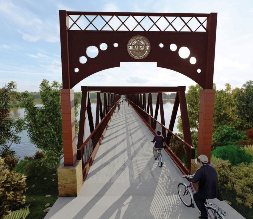
University of Wisconsin – Madison/Cooperative Extension
                   Department of Planning and Landscape Architecture

 Potential Economic Effects of The Gateway to
           The Driftless Trail System
  A Case Study Including the Great Sauk, Walking Iron, Wolf
 Run, and Black Earth Creek Trails in South Central Wisconsin

   Jenny Erickson, Mindy Habecker, Christopher James, Marty Krueger, Matt Kures,
               Christopher Long, Dave Marcouiller, and Jared Pinkus *

                                   Applied Research Report 21.1
                                          January 2021

         Cover illustration: Wisconsin River Recreation Bridge Design Concept, December 2019
                            Westbrook Engineering/MSA Professional Services

* Jenny Erickson and Mindy Habecker are University of Wisconsin – Madison County Extension
Educators. Christopher James is Senior Landscape Architect for the Dane County Parks Department.
Marty Krueger is a Sauk County Supervisor and chairperson of the Great Sauk State Trail Commission.
Christopher Long is chairperson of Gateway to The Driftless, a nonprofit community organization. Jared
Pinkus is Sauk County Community Development Coordinator. Matt Kures and Dave Marcouiller are
state specialists with the University of Wisconsin – Madison Division of Extension. Authors are listed in
alphabetical order with lead authorship shared equally.

                                                    1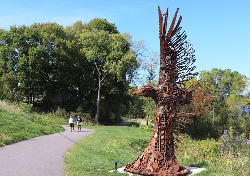
Executive Summary
Publicly available recreational trails provide recreational amenities that connect
communities. Maintaining and improving these corridors provide an example of
amenity-based development that is increasingly evident across the Midwest and
throughout the nation.
The potential of trails-based development to provide more vibrant and diversified
community economies provides the focus of this project. In this report, we outline
recent efforts to estimate the potential of one such trail system in South Central
Wisconsin and combine it with elements that will be useful in stimulating recreational
use, connections between communities, and the subsequent local economic impacts that
could result.
This was done using previous research, drive-time assessment of markets, semi-
structured interviews, and input-output analysis. Results suggest several important
marketing and public policy initiatives.
Key findings of this study include:
Trails stimulate local quality of life and business activity and are increasingly
seen as a central component of a sustainable future.
Current use of trails in South Central Wisconsin, while significant, would benefit
from a key linchpin connection of a recreational bridge crossing the Wisconsin
River at Sauk City, Wisconsin, connecting the Dane County and Sauk County
parts of the trail.
By connecting Madison, Devil’s Lake State Park, the Black Earth Creek
recreational corridor, Lower Wisconsin State Riverway, Ice Age Trail, and other
major state trails, the 60-mile Gateway to The Driftless Trail System, once
completed, is expected to be the busiest trail in the state.
The Gateway to The Driftless Trail System will enhance local quality of life for
area residents and is expected to increasingly attract non-local users from longer
distances and the estimated population of more than 15 million residing within a
three-hour drive time.
Within fifteen minutes’ drive time to recognized trail access locations, there
exists an active recreational base in excess of 700,000 bicycling participant-days
and over 200,000 snowmobiling participant-days. At 180 minutes’ drive time, the
estimated participation rates increase to in excess of 45 million and 15 million,
respectively.
2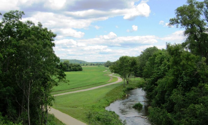
Recent studies suggest that trail bicyclists, on average, spend just over $41 per
individual participant-day while snowmobilers spend almost $44 per individual
participant-day.
For every 100,000 non-local participant-days, local stimulus creates 50 local jobs
and over $3,000,000 in local income.
Local restaurants, hotels, and retail shops are primary sectors of trails-based
stimulus with indirect effects felt in local real estate, construction, and service
sectors; output multipliers resulting from this stimulus in the Sauk and Dane
County region range from 1.6 to 1.8.
An effective regional branding and promotion program will be needed to
develop this trail system as a destination and fully realize its potential economic
stimulus effects to local communities and the state.
Projections in this study are based on historical data and do not reflect the
unprecedented high usage of state and county outdoor recreation facilities in 2020 as a
social effect of the COVID-19 pandemic and the greater preference Americans have
recently expressed for car-based trips, outdoor recreation, and travel to nearby
destinations. If current trends become permanent factors driving usage of public
outdoor recreation facilities, including the regional trail, its potential economic benefit
could exceed present expectations.
This study has adopted the “Gateway to The Driftless” designation given to the project
geography by the late Philip H. Lewis, nationally known University of Wisconsin-
Madison professor of landscape architecture, in recognition of his far-sighted vision for
regional sustainable planning.
3
Potential Economic Stimulus of the Gateway to The Driftless Trail System:

  A Case Study Including the Great Sauk, Walking Iron, Wolf Run, and Black Earth Creek Trails in
                                    South Central Wisconsin

                                      Table of Contents

Section                                                                                    Page

Executive Summary                                                                                  2

Table of Contents                                                                                  4

1. Introduction                                                                                    6

2. Approach Used to Estimate Potential Economic Impacts                                        12

3. South Central Wisconsin and the Market for a Trail System                                   15

4. The Potential Economic Impacts of Trip-Related Expenditures                                 17

5. Perceptions of Business and Community Leaders                                               21

6. Summary, Conclusion, and Policy Implications                                                23

Acknowledgments

References

Appendix A
Appendix B

                                                4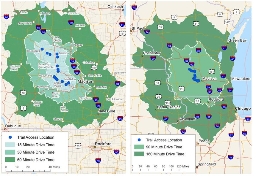
Lists of Tables & Figures Page
Table 1. Overview of studies used in this assessment 14
Table 2. Recognized participation rates combined with demographic profiles for potential
users of the Gateway to The Driftless (GTTD) Trail System within short-term and long-term
drive times 16
Table 3. Average expenditure pattern of relevant users of proposed system 17
Table 4. Economic impacts of 100,000 non-local bicyclist participant-days 19
Table 5. Top 10 sectors affected by 100,000 non-local bicyclist participant-days 20
Table 6. Economic impacts* of 100,000 non-local snowmobiler participant-days 20
Table 7. Top 10 sectors affected by 100,000 snowmobiler participant-days 21
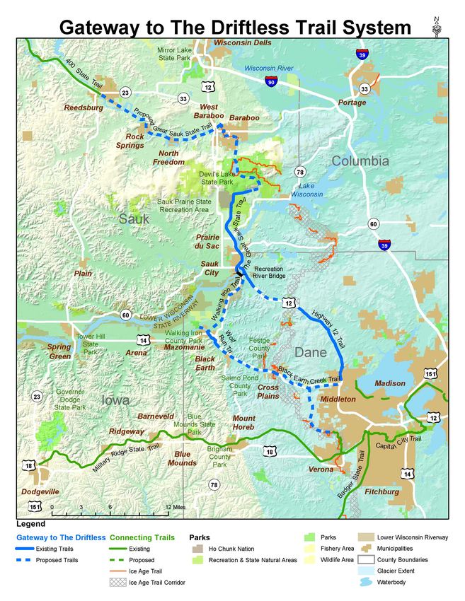
Figure 1. The Gateway to The Driftless Trail System relative to major market centers 8
Figure 2. Great Sauk State Trail & The Protector of the River, Sauk City 9
Figure 3. Wolf Run Trail & Black Earth Creek, Mazomanie 10
Figure 4. The Gateway to The Driftless Trail System project-level view 11
Figure 5. Visitation of the Wisconsin State Trail System during the recent past 13
Figure 6. Short-term and long-term drive times to recognized trail access locations 15
Figure 7. Wisconsin River Recreation Bridge Design Concept, December 2019 25
5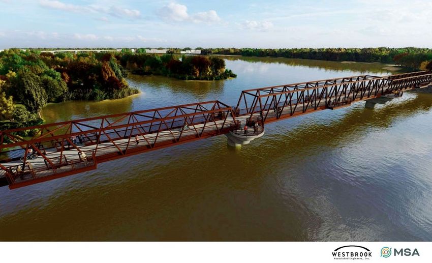
Potential Economic Stimulus of the Gateway to The Driftless Trail System

   A Case Study Including the Great Sauk, Walking Iron, Wolf Run, and Black Earth Creek Trails
                                   in South Central Wisconsin

                                       1. Introduction

Trails serve as an important venue for outdoor recreation. They connect communities
and provide user experiences that are physically active, family-friendly, and connected
to the natural world. As part of the built environment, trail systems possess several
attributes that stimulate local quality of life. In addition to their recreational attraction,
they serve as transportation corridors for commuting, open space and greenways, and
enhancement of local property values (Crompton 2010). Indeed, trails are increasingly
seen as a central component of a sustainable future.

The increased use of trail systems provide stimulus to local business activity. This is
particularly true for those activities catering to the needs of trail users. These include
restaurants, convenience stores, souvenir shops, and snack vendors. They also extend
to recreational equipment retailers, repair shops, and amusements. These direct
recipients of trail user spending have connections throughout communities and are
increasingly seen as key drivers to local economic vibrancy (Headwaters Economics
2020) and serve as the basis for amenity-based development (Cherry and Rickman 2010;
Green et al. 2005).

The potential of trails-based development to stimulate local economic activity and
provide more vibrant and diversified community economies provides the focus of
efforts described in this report. In this case study research, we develop estimates for the
potential economic effects of trails-based development for a system of trails that span
South Central Wisconsin. A key linchpin connection resulting from the reconstruction
of the railroad bridge over the Wisconsin River in Sauk City, Wisconsin is currently
being planned. Once complete, this trail will provide a seamless connection between
Madison and Devil’s Lake State Park. This bridge combined with development of new
trail segments and a concerted marketing effort to stimulate and coordinate increased
multi-purpose recreational use of this trail system provides the basis for our estimates.

Trails-based development and related recreational amenities suggest that the potential
economic benefits also include the ability of communities to retain and attract
permanent residents as well as new employers and employees, both important
contributing factors to a sustainable local economy that merit additional study (Manton
et al. 2016; Southwick et al. 2009). Long-term planning for economic development and
sustainable growth by local governments in the corridor has identified the potential of
the trail to be a multi-dimensional regional economic asset (Brown 2020; Iowa DoT
2001).
                                               6
Studies of regional trails suggest broad-based economic benefits (Crompton 2010; Hass
et al. 2006; Prey et al. 2013). These involve the economic benefit of the Gateway to The
Driftless Trail System that extends to towns by boosting a wide range of local
businesses and positive premiums that lead to higher property values (Lindsey et al.
2004; Krizek 2006; Mogush et al. 2004). Potential benefits typically found in these
unincorporated areas include:

   •   Increased property values based on the hedonic premiums associated with trails
       as an amenity resource
   •   Increased bookings for bed & breakfasts and guest homes
   •   Increased demand for rural restaurants and taverns, roadside farm stands, and
       convenience stores
   •   Growth of special events including driving tours of restored prairies,
       conservancies and natural areas, and local artist studios
   •   Increased demand for agritourism and outdoor recreation enterprises (fishing,
       hunting, wildlife study, horseback riding)
   •   Increased support for “local food” and Community Supported Agriculture (CSA)
       enterprises
   •   Increased attendance at rural festivals and other family outdoor events year-
       round.

By providing local residents of all ages with safe places to exercise, relax, and enjoy
nature, the regional trail will enhance quality of life and help retain and attract
businesses, workers, and residents to the towns. The associated growth in property
values would benefit town government and school district finances.

The Gateway to The Driftless Trail System

The Gateway to The Driftless Trail System could be the most prominent investment in
outdoor recreation in South Central Wisconsin. In 2007, the Sauk County Board of
Supervisors first pledged their support of a multi-use trail through the Villages of Sauk
City and Prairie du Sac. It took another seven years before the next resolution passed,
this time authorizing an intergovernmental agreement creating a trail development
commission. The expansion of the trail has progressed at a rapid pace but still cannot
keep up with the demand to see the Great Sauk State Trail bisect the entirety of Sauk
County. To date, over $3.25 million has been allocated for the trail. Funding has been
provided from traditional State and local agencies along with over $650,000 from the
Friends of the Great Sauk State Trail and another $560,000 from proceeds of the sales of
salvaged trail material. The current trail system in Sauk County is comprised of two
segments. On October 19, 2017, the first segment of the Great Sauk State Trail was
officially opened. The Prairie du Sac/Sauk City Segment (5.17 miles) begins at the
southern boundary of the former Badger Army Ammunition Plant, traverses
downtown Prairie du Sac, continues through Sauk City and terminates at the Wisconsin

                                             7
River Rail Bridge. This segment represents an urban section of trail that can coincide
with downtown placemaking and economic development initiatives. The Great Sauk
State Trail location is found in Figure 4.

Figure 1. The Gateway to The Driftless Trail System relative to major market centers (source:
          Kenneth Townsend, NASA, Natural Earth, John Nelson)

Just over one year later, on October 26, 2018, the second segment of the Great Sauk State
Trail, the Badger Segment, was opened. The Badger Segment (6.75 miles) begins just
south of Devil’s Lake State Park and concludes at the southern boundary of the former
Badger Army Ammunition Plant. Construction will begin on the expansion of this
segment through what is known as the Wye, a portion of rail line that was used to
transfer loads moving from north to south. Once complete through the Wye, the Great
Sauk State Trail will be adjacent to Devil’s Lake State Park, ensuring a significant
increase in utilization.

                                               8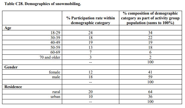
Figure 2. Great Sauk State Trail & The Protector of the River, Sauk City Photo by Jonathan Cody

In Dane County, the concept of an off-road, multi-use, year-round recreational trail
extending from Madison/Middleton to Mazomanie and from Mazomanie to a
Wisconsin River bridge crossing to Sauk County has long enjoyed area governmental
and community support. Since 2001, the Dane County Parks and Open Space Plan
(POSP) has included the concept of a Northwest Dane County regional trail that
interconnects people to neighborhoods, businesses, parks, schools, public facilities, and
environmental features. The trail is also included on the Wisconsin Department of
Natural Resources (WDNR) State Trail Map. This trail intends to be both recreational
and transportation-based and connects to the complex of high-traffic, multi-use public
trails serving Madison and southern Wisconsin. The first constructed segment in the
Middleton to Mazomanie part of the corridor, Wolf Run Trail, was completed in 2014 as
a two-mile, year-round, multi-use trail between downtown Mazomanie and Wisconsin
Heights Middle/High School campus, supported by funding from Dane County Parks
and the WDNR.

                                               9
Figure 3. Wolf Run Trail & Black Earth Creek, Mazomanie Photo by Gateway to The Driftless
The Dane County trail comprises two corridors, with the Village of Mazomanie serving
as the trail hub:
● The proposed “Black Earth Creek Trail” in Northwest Dane County is
envisioned to generally follow the creek and trail corridor, including the existing
Wolf Run Trail, and provide connections between the City of Middleton and
Villages of Cross Plains, Black Earth, and Mazomanie.
● The Mazomanie to Sauk City proposed “Walking Iron Trail” is envisioned to
generally follow the existing rail corridor through the WDNR Lower Wisconsin
State Riverway to a future multi-use recreational bridge crossing over the
Wisconsin River, providing a connection to the Great Sauk Trail in Sauk County.
10Figure 4. The Gateway to The Driftless Trail System project-level view (source: Joe
Fleischmann, GIS Coordinator, Sauk County Land Information/GIS)
11Following this introduction, this report is organized into five subsequent sections. First,
we describe the methods used to estimate potential economic stimulus resulting from
completion and marketing of this trail system. The next section outlines the current and
potential market for a trail system of this nature. We follow with results that outline
potential economic stimulus estimates. The next section provides context from business
and community leaders based on semi-structured interviews. The report concludes with
a general discussion that summarizes our work, identifies limitations and further
research needs, and policy implications of our findings.
2. Approach Used to Estimate Potential Economic Stimulus
It must be stated up-front that the Gateway to The Driftless Trail System currently exists
as unconnected strands. While current usage is significant, it is sporadic and limited by
a lack of connections and marketing. Concerted effort over the next few years will work
to complete, connect, and correct these limitations. Thus, our use and impact estimates
should be considered educated guesses, at best.
We can use the last 15 years of statewide trails usage as a benchmark upon which to
gauge relative potential usage. A summary of State Trail System usage is contained in
Figure 2. Note that the current system of state trails annually experiences roughly one
million participant-days (meaning the number of participants multiplied by the number
of days) and has shown modest change over time. While visitation increases were
witnessed between 2008 and 2011, little significant growth has taken place during the
assessment period.
12Figure 5. Visitation of the Wisconsin State Trail System during the recent past (in
participant-days by fiscal year from 2002 through 2018; source: Wisconsin,
State of 2020)
Characteristics of trail users and potential markets
Previous studies of trail user characteristics assisted in providing estimates used in this
work. Our estimates of trail user expenditures were based on a meta-analysis of
previous studies; these were collected, examined for relevance, and analyzed to place
bounds on our estimates. This summary of extant knowledge with respect to trail
systems was comprehensive. While most of the studies we encountered were from the
Midwest, several focused on other parts of the United States and elsewhere. Given the
contemporary nature of amenity-based development, we were most interested in recent
studies from the past 20 or so years. It is important to note that we were primarily
interested in the peer-reviewed literature but found this limiting with respect to specific
results required by our estimation procedures. Namely, many of the articles in the
peer-reviewed literature lacked usable expenditure patterns that allowed us to assess
the extent of local influence. This said, much of the usable information needed in this
assessment was obtained from technical reports; many of which originated from
Cooperative Extension sources. The most relevant studies are listed and partially
summarized in Table 1.
13Table 1. Overview of studies used in this assessment
Study Expenditure type and brief notes Year
Kazmierski et al. 2009 Usable expenditure patterns for multi-use trail system 2009
Carper et al. 2013 Motorized by season for Cheese Country Trail 2011
Venegas 2009 Usable expenditure patterns for various trail uses (MN) 2008
Berard et al. 2014 Usable expenditure patterns for competitive trail users 2013
Stynes and White 2005 Biking, hiking, and driving for pleasure 2003
White et al. 2016 Expenditure by broad site types and visitor characteristics varied
Ermagun and Lindsey 2016 Central Ohio Greenway users (NUEP) 2014
Tuck and Linscheid 2016 Mesabi MN trail users (mainly bicyclists) 2014
Bicycle Federation of WI Statewide Wisconsin; (NUEP)
Smith and Tisdale 2014 Vasa Pathway participants 2013
Nau 2015 Winnebago Co trail users (NUEP) 2015
Bowker et al. 2007 Virginia Creeper Trail SW VA; usable expenditure pattern 2004
Grabow et al. 2010 Wisconsin statewide (NUEP) 2009
Oswald-Beiler et al. 2015 Counts of trail users over time (NUEP) 2012
Monz and Kulmatiski 2016 Fat tire bikers (NUEP)
Southwick et al. 2009 Nationwide by region (NUEP)
Mogush et al. 2004 Hedonic study of trail impact on real estate (NUEP)
Manton and Clifford 2016 Greenway users; Europe varied
Beeton 2010 Usable expenditure pattern but in Australian Dollars 2006
Notes: NUEP = no usable expenditure pattern
Further, our market assessment utilized drive-time estimates obtained from ESRI (ESRI
2020). These drive times were based on average traffic patterns during 2019 to
recognized trail access points identified from parking lot locations. For consideration,
we specified 15, 30, 60, 90, and 180-minute drive time estimates. This was done to
identify potential future markets for the Gateway to The Driftless Trail System and are
graphically presented in Figure 6.
Note from Figure 6 that short-term drive times (up to 60 minutes) extend the market
reach of this trail system from Tomah to Janesville, Wisconsin (NW to SE) and nearly
Dubuque, Iowa to the western suburbs of Milwaukee (SW to NE). If we extend the
market reach to longer-term drive times (up to 180 minutes or 3 hours), we now include
most of Chicago, Illinois and Rochester, Minnesota plus the eastern suburbs of the Twin
Cities, an area with a total population of more than 15 million (ESRI 2020).
14Figure 6. Short-term (left) and long-term (right) drive times to recognized trail access
locations (source ESRI 2020)
Demographic profiles of populations within each drive time were obtained and
analyzed (results of which are found in the next section). Further, our analysis focused
on various types of trail users and their participation rates. Specific estimates of
participation in bicycling of rail trails/developed trails and snowmobiling were
obtained from the recently released Wisconsin Statewide Comprehensive Plan (WDNR
BPR 2019). Specific participation rate data for various demographic groups that reflect
statewide estimates are summarized in Appendix A.
3. South Central Wisconsin and the Market for a Trail System
Trails provide amenities that serve as recreational attractants for outdoor recreationists.
The region surrounding the proposed trail system near Madison, Wisconsin contains a
wide variety of transportation infrastructure and amenity-based destinations. Chief
among these are the bucolic landscapes of western Dane County, Devil’s Lake State
Park, the remnants of the vast acreage contained by the historic Badger Army
15Ammunition Plant, and the Wisconsin Dells. Certainly, the Baraboo Bluffs and adjacent
driftless region provides natural beauty and topographical variety.
The market for recreational use of the Gateway to The Driftless Trail System is
potentially quite extensive. It is important to note that short-term drive times are
expected to provide most of the initial trail usage assuming the completion of the
recreation bridge at Sauk City combined with an effective marketing strategy to entice
participation. Nevertheless, our estimates relate specifically to the demographics of
known participants and exist as potential target user groups.
Table 2. Recognized participation rates combined with demographic profiles for
potential users of the Gateway to The Driftless (GTTD) Trail System within
short-term and long-term drive times (source ESRI combined with data found
in the 2019-2023 Wisconsin Statewide Comprehensive Outdoor Recreation
Plan; WDNR 2019).
Participant-days2
Drive time (in minutes) to Trail
nearest GTTD Trailhead1 Bicyclists Snowmobilers
0-15 722,000 252,000
0-30 1,789,000 624,000
0-60 3,188,000 1,113,000
0-90 7,409,000 2,586,000
0-180 45,153,000 15,757,000
1. as specified in Figure 2 for short-term (15, 30, 60-minute) and long-term (90 and 180-minute) drive times assuming normal
average traffic patterns in 2019; inclusive from zero-minute.
2. based on survey data of Wisconsin residents and accounting for multiple numbers of participant-days; for adult participants
labeled as (1) bikers of rail trails/developed trails and (2) snowmobiling; rounded to nearest thousand.
As stated, we look to potential markets to assess the opportunity for increasingly larger
user numbers. As noted in Table 2, local user groups that exist as likely initial trail
system users exist in numbers that exceed 700,000 participant-days. Certainly, as the
trail extends and connects to an increasing regional trail system, user groups beyond
the local 15-minute drive time are possible. For estimates of potential use beyond a 15-
minute drive time estimate, we summarize these populations in Table 1. These relate to
short-term (30 and 60-minute drive times from Figure 6) and longer-term users (90 and
180-minute drive times in Figure 6).
The attraction of the trail system is expected to draw an increasing number of non-local
visitors (or people who are not residents of Dane and Sauk Counties). This is a key
element associated with economic stimulus due to the “export” nature associated with
tourism benefits. Non-local visitors bring new currency into local communities that
16would not exist without these visits. As the Trail System becomes increasingly well-
known to potential non-local visitors, a travel destination develops. The destination
life-cycle literature has long identified such phenomena and points to the differing
levels of visitor travel distance as regions develop around a specific destination (Butler
1989; Marcouiller 2013). A graphic of this distinction between local attraction, early-
stage destination, and mature stage destination that reflects increasing visitor travel
distance is summarized in Appendix B.
Current usage is only partially relevant to our assessment as much of the potential trail
use will result from an expanded trail (bridge across the Wisconsin River Bridge at Sauk
City) and concerted marketing and information dissemination once completed. It is
important to note that usage of the trail in the future remains unknown and exists as an
opportunity for those responsible for expansion and marketing.
4. The Potential Economic Stimulus of Trip-Related Expenditures
One approach to estimating the potential economic stimulus resulting from trail
systems rests on survey-based estimates of trip-related spending. Wide variation exists
in these estimates and is dependent on user type, user origin, travel distance, and other
attributes of an attraction. Reasonable estimates of spending can be benchmarked from
a variety of studies (Venegas 2009; and others listed in Table 1). These previous studies
allow us insights into the extent of economic stimulus. On average amounts of trip
spending for user types relevant to this trail system are provided in Table 3 for trail
bicyclists and snowmobilers.
Table 3. Average expenditure pattern of relevant users of the
proposed Gateway to The Driftless Trail System
Average Expenditure Pattern*
Type of Spending Trail Bicyclists Snowmobilers
Groceries/Liquor $3.23 $3.43
Restaurants/Drinks $6.37 $8.14
Gas, Auto Service $8.30 $6.68
Recreational Equipment $0.31 $0.26
Other Retail/Shopping $5.75 $1.27
Casino/Gambling $1.98 $2.54
Overnight Accommodations $13.63 $17.96
Rental & Repair $0.48 $1.40
Payments to Public Agencies $1.27 $2.28
Total individual Spending $41.32 $43.97
* per person per day based on evaluation and adaptation of various previous expenditure
pattern studies; normalized, inflated, and adjusted to represent 2020 spending.
17Note from this table that, across studies, there is a strong tendency for these to reflect
non-local visitors. This statement is justified given the simple fact that the primary
category of spending in these expenditure patterns is for “Overnight Accommodations”
combined with the notion that local residents are far less likely to spend in this
category. This tendency for expenditure patterns to reflect non-local visitors is likely
due to the nature of trails as a travel destination. Thus, we anticipate these types of
expenditure patterns to become increasingly apparent as the trail system develops over
time.
This said, broader economic impact assessment based on trail system usage can be
gleaned from the use of input-output analysis. Input-output analysis (sometimes
referred to as “interindustry analysis”) is a well-recognized tool for assessment of
economic impact (Shaffer et al. 2005). A full description of this tool is beyond the scope
of this report. Suffice it to say that input-output analysis rests on regional economic
structure and relationships (or linkages) that exist between firms and households. It is
specific to regional type and characteristics. Certainly, more urban regions have
broader sets of linkages as compared to rural regions due to issues associated with
agglomeration, economic diversity, presence of forward- and backward-linked firms,
export and import balances, and household income differences. Input-output analysis
and related tools rest on an export-based approach to economic growth. This is well-
suited to our assessment of non-local visitor attraction and serves as the basis for our
assessment of potential economic stimulus resulting for the development of the
Gateway to The Driftless Trail System.
One readily available input-output modeling system (and the one used for this
assessment) is IMPLAN. This software and accompanying dataset have been in
continuous use for the past 40 years and are regularly updated. 1 This system and the
accompanying 2016 data for Sauk and Dane Counties in Wisconsin were used for the
following economic impact scenarios. These scenarios relate to the ability of the Trail
system to attract non-local visitors. For simplification, we limit our assessment to the
ability to attract two types of non-local visitors to the region delineated by Dane and
Sauk Counties for purposes of leisure travel. Both bicyclists and snowmobilers provide
the focus and we are specific to estimates based on attracting 100,000 non-local visitors
in each category.
Economic impacts of non-local spending
Assessing trail bicyclists uses the average expenditure pattern from previous studies as
summarized in Table 3. This expenditure pattern is matched with appropriate
IMPLAN sectors and is injected using producer prices (net of margins). These reflect
the fact that trip-related spending by non-local visitors represents consumer spending
1 The interested reader is referred to instructional use materials found at https://www.implan.com/ .
18on a variety of items; some of which are localized using retail margins. In essence, only
a portion of the spending (net of retail margins) ends up contributing to local economic
impact. 2 The scenario for 100,000 non-local bicyclists is summarized in Tables 4 and 5.
Note from these tables that impact estimates are presented for four economic
characteristics. These include employment (in total number of jobs), labor income (e.g.,
employee compensation), total value added (a combination of all types of income
including proprietor’s income), and output (or the total amount of economic activity
affected by non-local visitor spending). Further, the analysis reflects four types of
effects. These include the direct effects (stimulus related only to non-local trip
spending), indirect effect (or the stimulus resulting from increased demands by firms
directly affected by non-local trip spending), induced effect (or that stimulus resulting
from demand of increased local household incomes), and total effect. Readers
interested in further discussion of economic characteristics, regional type, or input-
output effects are referred to the textbook entitled Community Economics (Shaffer et al.
2004)
Table 4. Economic impacts of 100,000 non-local bicyclist participant-days
(2020 IMPLAN results)
Impact Type Employment** Labor Income Total Value Added Output
Direct Effect 34.6 $965,000 $1,518,000 $2,756,000
Indirect Effect 6.4 $341,000 $626,000 $1,051,000
Induced Effect 6.5 $281,000 $542,000 $899,000
Total Effect* 47.6 $1,588,000 $2,687,000 $4,705,000
* may not sum to total due to rounding
** in total jobs
Note from this Table that attracting 100,000 non-local bicyclists would generate roughly
$4.7 million in total output. Included within this value is total income of $2.7 million
(total value added) and roughly $1.6 million in employee compensation. The remaining
income ($2.7 million - $1.6 million = $1.1 million) includes proprietor’s income,
property-type income, and indirect business taxes.
Direct and indirect impacts fall within a variety of local business sectors. The top 10
sectors of direct and indirect impacts are listed in Table 5. Induced effects reflect local
housing income change and the increases in consumption driven by increased income.
2A good example of this can be found with convenience stores that sell gasoline. In Wisconsin, average
retail margins for gasoline relate to the minimum markup (law) of six percent. Since the Sauk/Dane
County regional economy does not include the production of petroleum, much of what is purchased at
the pump as gasoline must be imported from outside this region and exists regionally as a leakage. Thus,
only the markup (or retail margin) remains for stimulating local economic activity.
19Table 5. Top 10 sectors affected by 100,000 non-local bicyclist participant-days
(2020 IMPLAN results)
IMPLAN Labor Total Value
Sector Sector Description Employment* Income Added Output
501 Full-service restaurants 14.0 $292,000 $325,000 $664,000
499 Hotels and motels 13.1 $402,000 $787,000 $1,367,000
405 General merchandise stores 2.5 $77,000 $112,000 $172,000
402 Gasoline stores 1.9 $65,000 $79,000 $127,000
400 Food and beverage stores 1.6 $48,000 $67,000 $105,000
495 Gambling industries 1.6 $45,000 $83,000 $203,000
440 Real estate 0.9 $18,000 $211,000 $264,000
503 Other food and drinking places 0.7 $18,000 $14,000 $28,000
443 Consumer goods rental 0.6 $25,000 $32,000 $50,000
468 Services to buildings 0.5 $10,000 $12,000 $20,000
* in total jobs
Assessing snowmobilers again uses the average expenditure pattern from previous
studies as summarized in Table 3. Like the previous user group, this expenditure
pattern is matched with appropriate IMPLAN sectors and is injected using producer
prices (net of margins). Once again, these reflect the fact that trip-related spending by
non-local visitors represents consumer spending on a variety of items; some of which
are localized using retail margins. In essence, only a portion of the spending (net of
retail margins) ends up contributing to local economic impact. The scenario for 100,000
non-local snowmobilers is summarized in Tables 6 and 7.
Table 6. Economic impacts of 100,000 non-local snowmobiler participant-days
(2020 IMPLAN results)
Impact Type Employment* Labor Income Total Value Added Output
Direct Effect 42.2 $1,193,000 $1,897,000 $3,471,000
Indirect Effect 8.1 $430,000 $786,000 $1,322,000
Induced Effect 8.1 $350,000 $673,000 $1,117,000
Total Effect 58.4 $1,973,000 $3,356,000 $5,909,000
*in total jobs
Note from these tables that economic impacts of the same amount of snowmobiler
participant-days is larger than bicyclists and reflects higher levels of trip-related
expenditure patterns. Interpretation of results in both Tables 6 and 7 are analogous to
the above discussion.
20Table 7. Top 10 sectors affected by 100,000 snowmobiler participant-days
(2020 IMPLAN results)
IMPLAN Labor Total Value
Sector Sector Description Employment* Income Added Output
501 Full-service restaurants 17.9 $373,000 $415,000 $848,000
499 Hotels and motels 17.3 $529,000 $1,036,000 $1,798,000
495 Gambling industries 2.0 $58,000 $106,000 $260,000
400 Food and beverage stores 1.8 $52,000 $73,000 $114,000
443 Consumer goods rental 1.6 $72,000 $92,000 $142,000
402 Gasoline stores 1.6 $54,000 $65,000 $105,000
440 Real estate 1.1 $22,000 $260,000 $325,000
503 Other food and drinking places 0.9 $23,000 $19,000 $36,000
405 General merchandise stores 0.8 $24,000 $35,000 $54,000
468 Services to buildings 0.7 $13,000 $15,000 $25,000
* in total jobs
5. Context from Business and Community Leaders
For context, effort was made to solicit perceptions of business and community leaders
within the region affected by the trail system. A series of semi-structured interviews
with selected leaders was conducted via face-to-face, telephone, and email
communication. The purpose of the interviews was to learn more about the impacts of
the current portions of The Great Sauk State Trail and Wolf Run Trail and the potential
that exists with further development of a formal trail system. Specifically, two county-
based University of Wisconsin Extension Educators each conducted 12-15 interviews in
their respective counties with local businesses and community leaders during the
summer of 2020. The businesses were selected either because they likely benefited from
the trail or they were similar to the types of businesses highlighted in marketing
materials from other trail systems. The interviewees were asked a series of questions
that included the following:
● How does the trail currently benefit your business? How does the trail benefit
your community?
● Have you adjusted your business or made investments to take advantage of the
trail? If so, how? If not, why not?
● What effect does the seasonality of the trail ridership affect your planning or
business?
● What could be done to further develop or refine the trail to benefit your business
and the community (i.e., coordination of events, parking, marketing, etc.)?
● Do you think businesses 20 miles further along the trail should be excited about
the trail coming to their community? If so, why? If not, why not?
21● What percent of your business is associated with trail ridership? How did you
estimate this?
● Ideally, what percentage of your business do you hope would be attributed to
the trail?
Content analysis of responses to these questions was used to provide context for the
numerical estimates of trail user impacts and the developmental attributes specific to
business and community leaders. Results of these semi-structure interviews suggest the
following:
● Nearly all respondents commented that trail ridership exceeded
expectations. This sentiment was underscored by Alan Wildman, Administrator
for the Village of Prairie du Sac, “There are an amazing number of daily users -
walkers, bikers, and runners. I can't get over how much it is used.” Many also
commented that ridership increased due to the COVID-19 pandemic. The trail
was seen as a safe place.
● Respondents felt that the trail had become a destination, and they included
comments about how the bike racks and parks were full on the weekends.
● Respondents shared a number of suggestions to further develop the trail to
benefit local businesses including: better signage for businesses along the trail,
public restrooms, water fountains, art installations, increased marketing, more
parking and access points, trailhead kiosks, special events, and a map that
includes local businesses as well as trail highlights.
● Over half the respondents had made modifications to encourage trail traffic such
as installing bike racks, selling bike-related merchandise including a repair shop,
adding outdoor seating, and additional signage.
● As the regional trail is developed and traffic continues to increase, businesses
were more willing to make modifications to make their business more accessible
to bikers, hikers, and other recreational tourists. A number of businesses also
indicated they had additional plans to attract trail users but had not
implemented them yet.
● All the businesses were in favor of having the trail bring in year-round users. In
Dane County there was some disagreement on winter use. Some wanted silent
sports only and others already benefited from snowmobile use and encouraged
them. There are no motorized vehicles on this portion of the trail in Sauk
County.
● There was modest economic benefit from businesses that pull in bikers, hikers,
snowmobilers, and kayakers such as restaurants, bed and breakfasts, and
convenience stores. None of the businesses expected more than 5-15% of their
business to come from trail users. However, a representative of Vintage Brewery
in Sauk City representative stated, “People should not underestimate the traffic
bicyclists can bring. It is a great thing - it really is.”
22● There was no direct economic benefit from businesses that do not cater to
recreational users such as manufacturing firms, distribution centers. However,
many commented that the trail was an opportunity to showcase the community
and was viewed as an asset for their workforce.
● Nearly every respondent underscored the need to expand the trail throughout
both Sauk and Dane Counties. They viewed the future regional trail system as a
significant opportunity to attract additional tourists to their communities.
● All respondents thought that people 20 miles or further would like to come to
their community as the area has lovely unique rural character and charming
small communities with interesting downtowns.
● All respondents agreed that there is general community benefit in multiple
ways.
This was well described by a local real estate agent’s response.
“Trails are a great asset for communities. They help to create bonds among the
residents of all ages and lead people to take more pride in their community. So,
the community benefits and it may also help me sell homes there. Trails provide
opportunities to exercise, explore and meet people. A win for communities and
their businesses.”
Kathy Good, Realtor
6. Summary, Conclusion, and Policy Implications
The potential of trails-based development to provide more vibrant and diversified
community economies provides the focus of this report. Here, we outline recent efforts
to estimate the potential of the Gateway to The Driftless Trail System in Dane and Sauk
Counties in South Central Wisconsin and combine it with elements that will be useful in
stimulating recreational use, connections between communities, and the subsequent
local economic impacts that could result. This was done using previous research, drive-
time assessment of markets, semi-structured interviews, and input-output analysis.
Results suggest that the trail system will enhance local quality of life for area residents
and is expected to increasingly attract non-local users from longer distances and the
estimated population of more than 15 million residing within a three-hour drive time.
Within fifteen minutes’ drive time to recognized trail access locations, there exists an
active recreational base in excess of 700,000 bicycling participant-days and over 200,000
snowmobiling participant-days. At 180 minutes’ drive time, the estimated participation
rates increase to in excess of 45 million and 15 million, respectively. Recent studies
suggest that trail bicyclists, on average, spend just over $41 per individual participant-
day while snowmobilers spend almost $44 per individual participant-day.
23With respect to potential economic impacts, for every 100,000 non-local participant-
days, local stimulus creates roughly 50 local jobs and over $3,000,000 in local income.
Local restaurants, hotels, and retail shops are primary sectors of trails-based stimulus
with indirect effects felt in local real estate, construction, and service sectors; output
multipliers resulting from this stimulus in the Sauk and Dane County region range
from 1.6 to 1.8. An effective regional branding and promotion program will be needed
to develop this trail system as a destination and fully realize its potential economic
stimulus effects to local communities and the state.
A long-term vision supported by Dane and Sauk counties and WDNR for sustainable
growth and downtown revitalization in area communities has long included a regional
multi-use trail system. The envisioned Gateway to The Driftless Trail System would
connect major population centers to county and state park facilities and other trails and
the Lower Wisconsin State Riverway and allow winter snowmobile use where
appropriate. With the historic floods of August 2018 that devastated local communities
in the trail corridor, the need for economic stimulus and downtown revitalization grew
more urgent. The still unfolding impact of the current COVID-19 pandemic has only
increased the need in these communities for an achievable vision and viable path to
robust economic recovery and a future of sustainable growth. Recent events have only
strengthened the case for strong public and private support to make the regional trail a
reality.
The Great Sauk State Trail already has been a catalyst for development in the Villages of
Sauk City and Prairie du Sac. Along the trail, these communities have spent millions of
dollars redeveloping and expanding parks and public space, property owners have
invested private funds to rehabilitate their buildings, shops have expanded, and new
businesses have moved in. This type of development is a clear sign the Great Sauk State
Trail has far exceeded initial expectations of local communities. It is now time to see this
level of economic development expand through the rest of the county, from Devil’s
Lake through the City of Baraboo, to the 400 State Trail in the City of Reedsburg and all
the communities between.
In Dane County, the two-mile Wolf Run Trail, completed in 2014 between the Village of
Mazomanie and Wisconsin Heights High School, was the first segment of the Black
Earth Creek Trail to be implemented and was the result of cooperative and
collaborative efforts by the Wolf Family, the Wolf Run Association, the Village of
Mazomanie, Dane County, Wisconsin Department of Natural Resources, NRCS, and
Trout Unlimited. The trail now attracts a regional, year-round user base and is seen by
local government as a significant contributor to the community’s quality of life and
potential for sustainable economic development. In 2016 Dane County Executive Joe
Parisi established a $1 million matching fund available to local units of government and
non-profit organizations for the purpose of acquiring land from willing sellers needed
24for Black Earth Creek Trail connections between the City of Middleton and the Village
of Mazomanie.
In 2019, Sauk and Dane counties co-funded an $80,000 engineering feasibility study of a
new recreational bridge to replace the former rail bridge at Sauk City, dismantled in
2018, in order to connect Great Sauk State Trail and Walking Iron Trail in Dane County
for bike, pedestrian and snowmobile use. The study completed in December 2019 found
the 500-foot span feasible from an engineering standpoint and estimated the total cost of
construction at $8 million.
Figure 7. Wisconsin River Recreation Bridge Design Concept, December 2019
The Sauk and Dane 2021 county budgets include funds toward the shared cost for a
$146,000 geotechnical study of the Wisconsin River channel at the bridge site as part of
continuing design and engineering activities. Work was expected to begin in September
2020 and the final report is due in January 2021. The proposed Dane County budget also
included funds for analysis of additional railroad bridge crossings in the Walking Iron
Trail corridor. The Sauk County budget proposal also included carry-forward funds for
removal of railroad ties and construction of the Great Sauk State Trail "Wye" connection
to Devil’s Lake State Park and $25,000 for the development of a parking area and trail
connection on property near the State Highway 78 trail crossing.
25Dane County, Wisconsin & Southern Railroad Company, WDNR, WisDOT and the
Wisconsin River Rail Transit Commission have been discussing the potential of a future
multi-use trail along the existing rail corridor that could also accommodate railroad car
storage.
The Village of Mazomanie's "Mazo 2020" Economic Positioning Strategy, adopted in
2016, recommended the Village take action to become a recreational hub to the region,
with the goal of drawing visitors, new employers and employees, and new residents by
creating additional trails and regional trail connections to Middleton as well as Great
Sauk State Trail and Devil's Lake State Park. The Village study recommended a regional
branding effort for Northwest Dane County and the Black Earth Creek valley
communities. The Village of Mazomanie’s updates of its Community Outdoor
Recreation Plan (CORP) and Comprehensive “Smart Growth” Plan in 2020 both make
intergovernmental cooperation in development of the regional trail a matter of policy
toward the goal of enhancing quality of life and supporting economic development.
The Villages of Black Earth and Cross Plains have also developed comparable
marketing and economic opportunity studies that endorsed continued development of
the regional trail and called for a joint marketing effort around outdoor recreation,
abundant natural beauty, and quality of life. Gateway to The Driftless Inc., a nonprofit
regional economic development initiative established in partnership with the three
villages, local chambers of commerce, schools, and other nonprofit organizations and
civic groups, launched an interactive website (gatewaytothedriftless.com) in 2018 to
brand and promote the area around outdoor recreation and quality of life.
The Village of Black Earth's current reconstruction of its eight-acre community park
includes construction of a segment of the regional trail. The Village of Cross Plains,
headquarters of the Ice Age National Scenic Trail, has completed construction of a new
NW Dane regional trail segment within the Village and is now working with the
developer of a planned housing subdivision and other stakeholders to extend the trail
west to Dane County's Salmo Pond Park. A recent community survey by the Village of
Cross Plains Sustainability Committee (ad hoc) found a majority of 53 percent of
respondents would use a bike path to commute to Middleton or Madison.
This study shows strong potential for significant regional economic benefit from the
Trail System. The findings offer solid support for public and private investment in the
trail system’s continued development in order to achieve a long-held vision for future
growth and quality of life shared by local communities and government in Sauk and
Dane counties.
26The Importance of a Regional Marketing Program
Given the highly competitive nature of the visitor industry, we believe an effective
regional marketing effort will be needed to achieve the potential participation rates and
visitor expenditure impact projected in this study. Regional branding and promotion of
the Gateway to The Driftless Trail System needs to be part of a cooperative economic
development strategy among local communities in support of downtown revitalization
and long-term, sustainable growth of the project area.
We envision a marketing scheme that would highlight the natural beauty of the trail
system and its environs, the small-town character and quality of life of the trail
communities, the abundance of family outdoor recreation opportunities, and the area's
proximity to urban centers. It would complement outreach efforts around existing parts
of the system (Great Sauk State Trail, Wolf Run Trail) while being designed to reach a
larger audience with a comprehensive view of area attractions.
This messaging would be directed to a broad demographic across the seven-state upper
Midwest area and beyond with the goal of attracting visitors to the trail system and
nearby outdoor recreation opportunities. It would seek to attract visitors as well as
potential new residents, businesses, and workers to area communities and would thus
be actively supported year-round across electronic, digital, print, and person to person
(e.g., trade shows) platforms.
The regional branding and promotion effort should support marketing and branding
activities by local and state government and business stakeholders. It should also be
part of community planning and development of related infrastructure facilities and
amenities. As such, the regional marketing program would serve to implement local
and regional economic development strategy and investment. Support by a
combination of public and private resources is vital to future success.
Acknowledgments
The authors wish to thank the following for their valuable contributions to this study: Root
River (MN) Trail Towns; Gabby Kinneberg, Preston (MN) Area Chamber of Commerce; Jen
Hengel, Rushford Peterson Valley (MN) Chamber of Commerce; Jess Althoff, Minnesota DNR;
Dane County Supervisor Dave Ripp; Town of Mazomanie Chairman Fred Wolf, and Town of
Cross Plains Chairman Greg Hyer. Finally, we’d like to acknowledge the sage advice and time-
series data for trails usage provided by the Wisconsin Department of Natural Resources,
Bureau of Parks and Recreation and retired WDNR Senior Planner Jeffrey Prey.
27References
BBC Research and Consulting. 2014. Community and Economic Benefits of Bicycling in
Michigan. Phase I Final Report prepared for Michigan Department of
Transportation.
BBC Research and Consulting. 2014. Traverse City Case Study: Community and Economic
Benefits of Bicycling. Final Report prepared for Michigan Department of
Transportation.
Beeton, S. 2010. Regional community entrepreneurship through tourism: The case of
Victoria’s rail trails. International Journal of Innovation and Regional Development
2(1/2): 128-148.
Berard, DS, S Chapin, A Hoogasian, T Kane, DW Marcouiller, and T Wojciechowski.
2014. Understanding Active Silent Sports Enthusiasts: A Case Study of Gateway
Community Impacts from Northern Wisconsin. Extension Report 14-01, Department
of Urban and Regional Planning, University of Wisconsin - Madison/Extension.
Bicycle Federation of Wisconsin. The Economic Impact of Bicycling in Wisconsin.
Madison, WI
Bowker, JM, JC Bergstrom, and J Gill. 2007. Estimating the economic value and
impacts of recreational trails: A case study of the Virginia Creeper Rail Trail.
Tourism Economics 13(2): 241-260.
Brown, L. 2020. Trails and Economic Development Resources: An Annotated
Bibliography. University of Connecticut – Extension.
Budris, A, J Walsh, and L Brown. 2018. Downtowns as Community and Economic
Development Engines. Project report; Naugatuck Valley Council of Governments
and the.
Butler, RW 1989. The concept of a tourist area cycle of evolution: Implications for
management of resources. Canadian Geographer 26: 5-12.
Carper, C, J Guth, E Kakde, DW Marcouiller, P Ohlrogge, and L Wolfe. 2013. Motorized
Outdoor Recreation and Tourism Development within Trailside Communities.
Monograph G3569. Madison, WI: Board of Regents of the University of Wisconsin
System.
28Cherry, T and D Rickman (eds). 2010. Environmental Amenities and Regional Economic
Development. New York, NY: Routledge.
Crompton, JL. 2010. Measuring the Economic Impact of Park and Recreation Services.
Research Series 2010. Ashburn, VA: National Recreation and Park Association.
Dixon, N and B Ryan. 2006. How local businesses can serve trail users. Let’s Talk
Business Issue 121. Center for Community Economic Development: Madison, WI.
Ermugun, A and G Lindsey. 2016. Differences in spending by local trail users.
Transportation Research Record Number 2598: 58-66.
ESRI. 2020. ArcGIS output available from authors.
Fosher, H. 2018. Understanding the Marketing and Management of Trails Using Pestel
Analysis. Unpublished MS Thesis. University of New Hampshire: Durham, NH.
Glynn, D, T-L Hsu*, DW Marcouiller, and B. Ryan. 2018. Potential Economic Impacts of a
Proposed Whitewater Park: A Market-based Case Study from Stoughton, Wisconsin.
Extension Report 18-01, Department of Planning and Landscape Architecture,
University of Wisconsin – Madison/Extension.
Grabow, M, M Hahn, and M Whited. 2010. Valuing Bicycling’s Economic and Health
Impacts in Wisconsin. Nelson Institute for Environmental Studies, University of
Wisconsin – Madison: Madison, WI.
Green, GP, SC Deller, and DW Marcouiller (eds.). 2005. Amenities and Rural
Development: Theory, Methods, and Public Policy. New York, NY: Edward Elgar
Publishing.
Hass, E, N Dixon, B Ryan, and DW Marcouiller. 2006. A Proposed Bicycle and Horse Trail
from Spring Valley to Elmwood, WI: The Extent and Impact of Visitor Expenditures.
Extension Report 06-01, Department of Urban and Regional Planning, University of
Wisconsin – Madison/Extension.
Headwaters Economics 2020. Outdoor Recreation: A Top Driver of Wisconsin’s
Economy. https://headwaterseconomics.org .
Iowa Department of Transportation. 2001. Implementing Trail-based Economic
Development Programs: A Handbook for Iowa Communities. Iowa DoT: Des Moines, IA.
Kazmierski, B, M Kornmann, DW Marcouiller, and J Prey. 2009. Trails and Their
Gateway Communities: A Case Study of Recreational Use Compatibility and Economic
29You can also read