Potential of RGB images of INSAT-3D/3DR satellite in weather forecasting - RGB Experts and Developers Workshop 2017
←
→
Page content transcription
If your browser does not render page correctly, please read the page content below
Potential of RGB images of
 INSAT-3D/3DR satellite in
    weather forecasting
RGB Experts and Developers Workshop 2017

               Dr. Suman Goyal
                   Scientist E
        India Meteorological department
               New Delhi, India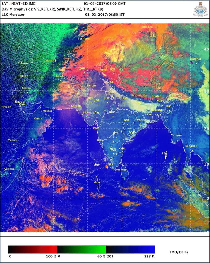
Locations of
         Indian Geostationary Meteorological Satellites

                          74o
                                  82o

  Full Disk                                         Full Disk
0 E to 140E                                       10 E to 150E
                   INSAT-3DR
                                INSAT-3D
INSAT-3D/3DR Imager channels
Channel no. Spectral Band Spectrum (μm)         Ground
                                               Resolution
                                                  (km)
    1           VIS       0.55 – 0.75 (0.65)      1x1
    2          SWIR      1.55 – 1.70 (1.625)     1x1

    3           MIR       3.80 – 4.00 (3.9)      4 X4

    4           WV        6.50 – 7.10 (6.8)      8x8

    5           TIR1      10.2 – 11.3 (10.8)     4x4

    6           TIR2       11.5 – 12.5 (12)      4x4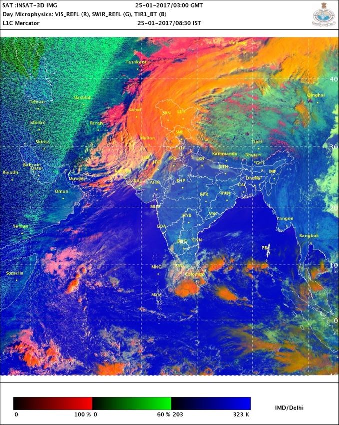
Physical properties / uses
  Channels (μm)               Physical Properties
     0.65           Low cloud, Fog (Absorption channel by
                      vegetation Reflection by Snow/ice)
     1.625        Cloud phase, Particle size and shape, optical
                   thickness (Strong absorption by Snow/ice
                               Reflection by dirt)
      3.9         Low cloud, fog, Fire, Particle size and shape,
                               optical thickness
     6.8                       Mid‐level moisture
     10.8                   Cloud top temperature
      12                  Cloud top temperature, SST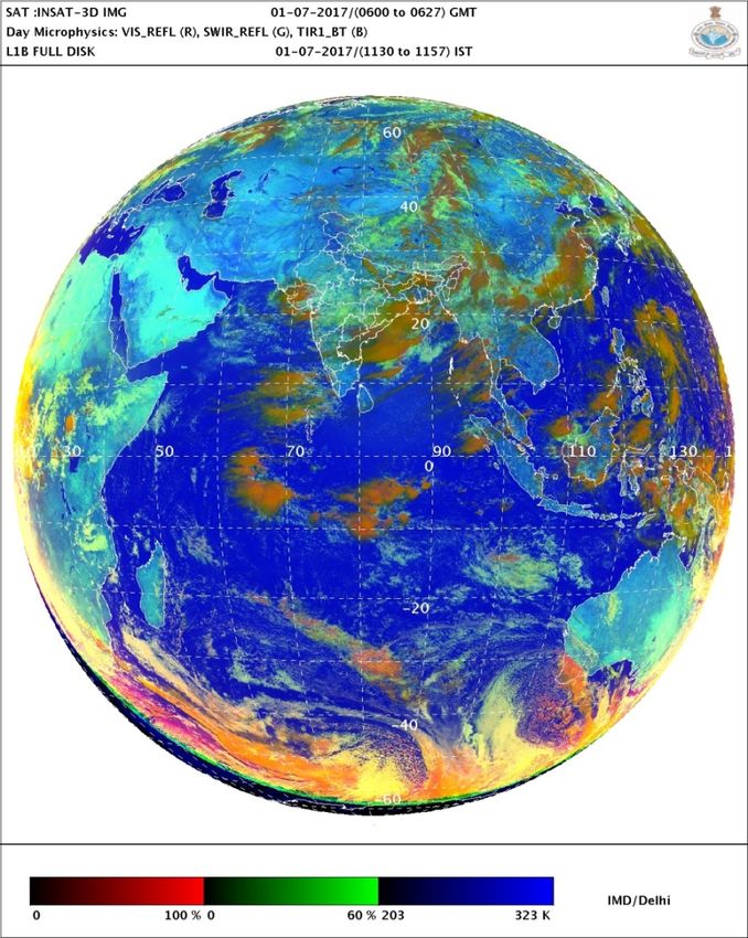
RGB DAY MICROPHYSICS

                         Recipe

RED – Vis (0.65µm) Reflectance

GREEN – SWIR (1.625µm) Reflectance

BLUE – TIR1 (10.8µm) BT

This product is used during the daytime because solar reflectance
component is adopted. Colors and their interpretation are based on
I. M. Lensky and D. Rosenfeld: Clouds-Aerosols-Precipitation Satellite
Analysis Tool (CAPSAT), Atmos. Chem. Phys.,8, 6739-6753, 2008i.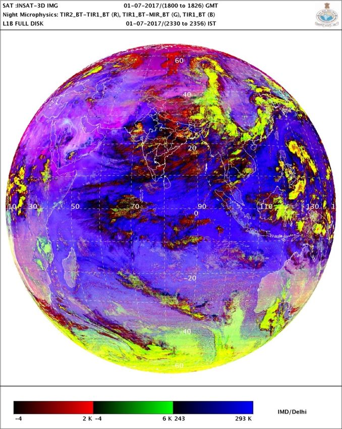
RGB RECIPE
• RED beam - visible reflectance at 0.64 μm approximates the cloud optical
depth (thickness) and amount of cloud water and ice.
          water cloud is more reflective than ice cloud and hence has a higher
red component.
• In the GREEN beam – The 1.67 μm SWIR (shortwave infrared) solar
reflectance gives a qualitative measure for cloud particle size and phase.
           smaller water droplets or small ice particles have a higher reflectivity,
resulting in a higher green component. A sandy earth surface also has a strong
reflectance in this channel.
• In the BLUE beam - The 10.8 μm TIR1 brightness temperature is a function of
temperature. For warm surfaces, higher blue component whereas very cold
cloud tops will have no contribution in this component.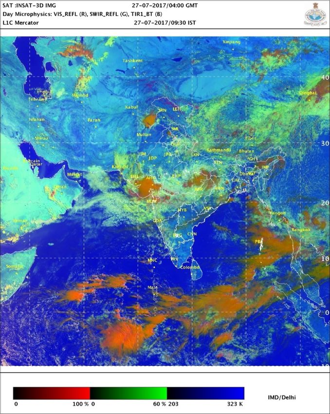
DAY MICROPHYSICS
USE IN FORECASTING
                        FOG
•   Climatologically know area
•   Sharp boundary
•   Stationary
•   Dissipation pattern
•   Nowcasting guidance
    is provided to aviation
    sector
•   Area can be calculated
       in RAPID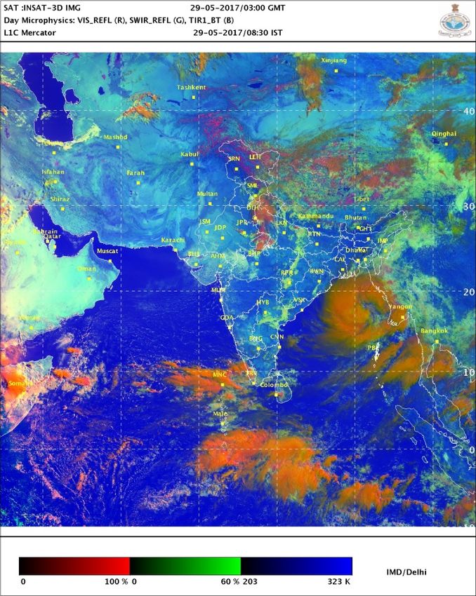
FOG Animation
LOW CLOUDS
• Texture and boundary different than that of fog
• Movement
• Lower TIR1 BT compared to Fog
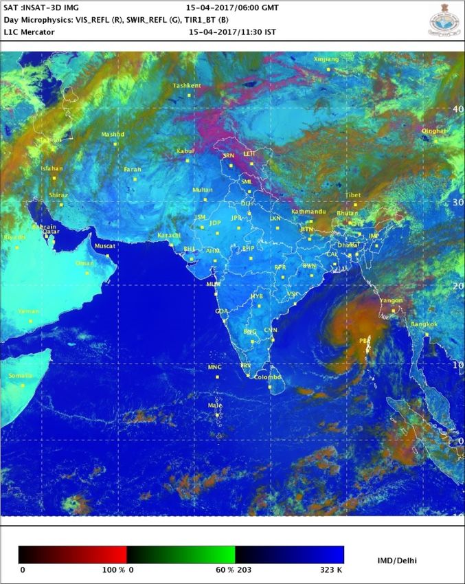
Low cloudsCUMULO-NIMBUS Cb Cells
Tropical Cyclone
Marutha 15th April, 2017, 0600 UTC   Mora 29th May, 2017, 0300 UTC
Tropical Cyclone rainfall obtained
             IMR Product
Marutha 15th April, 2017, 0600 UTC   Mora 29th May, 2017, 0300 UTC
Snow
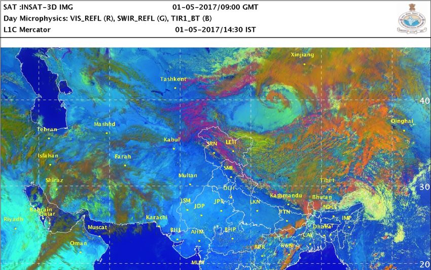
Western Disturbance and
 Monsoon depression
Day Microphysics vs
                  Actual observation

 Day Microphysics

                                 31 st September, 2017
                                       0600 UTC

Actual observations
ADVANTAGES AND LIMITATIONS • Can clearly distinguish between ice phase clouds at high elevations and water phase clouds at lower elevations, providing a pseudo three- dimensional view of the atmosphere • Can identify subtle microphysical variations within clouds that are not apparent on other images or RGBs • Helps discriminate between precipitating and non-precipitating water clouds • Can help identify severe convective clouds with strong updrafts Limitations: • The RGB is complicated in terms of the number and variety of colors and requires expertise to interpret it but it is a very powerful product • Only available during daytime
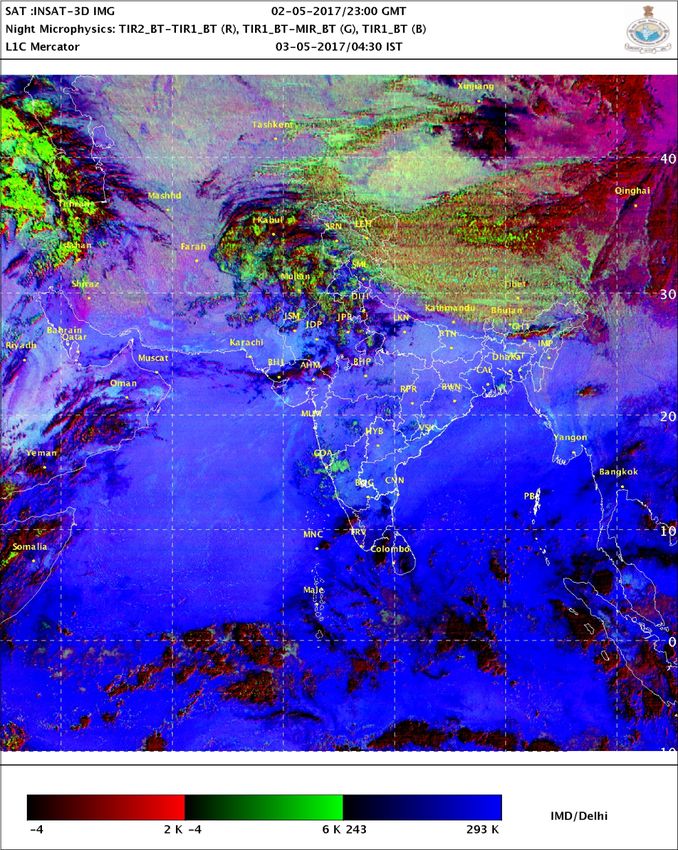
RGB NIGHT MICROPHYSICS
                Recipe

R = Difference TIR2 (IR12.0) – TIR1 (IR10.8)
   Optical Thickness, Tsurf-Tcloud,
   Lower tropospheric water vapour and cirrus

G = Difference TIR1 (IR10.8) - MIR (IR8.7)
   Optical Thickness, Phase, Tsurf-Tcloud

B = Channel TIR1 (IR10.8)
    Top Temperature
NIGHT MICROPHYSICS Cirrus
NIGHT-TIME MICROPHYSICS RGB IMAGERY The Night Microphysics RGB product is designed and tuned for monitoring the evolution of nighttime fog and stratus clouds. Secondary applications include detecting fires, classification of clouds in general, snow and low-level moisture boundaries. The distinction between low clouds and fog is often a challenge. While the difference in the TIR1 10.8μm and MIR 3.9μm channels is applied to meet this challenge, the Night-time Microphysics RGB adds TIR2 12.0μm channel difference to indicate cloud thickness and enhance areas of warm clouds where fog is more likely. Other applications of Night-time Microphysics RGB include analysis of cirrus and contrail clouds, fire hot spots, and snow.
Example of Dust

    Day MP        Night MP
Example of Dust on 6/4/2015 over Rajhasthan Day MP Night MP
Nightime Fog

1st January 2017, 0000 UTC Night microphysics
Sand/Dust
Mature CB Cloud

Mature CB with ice
                          Low cloud
Ocean Medium cloud
Land
Cirrus CloudComparison of INSAT 3D and METEOSAT RGB
products
INSAT-3D Day Microphysics Eumetsat Day Microphysics
VIS 0.65 µm (R), SWIR (1.625µm), VIS(R), 3.9 µm Solar reflectance (G),
TIR1_BT 10.8 µm (B) IR 10.8 µm (B)
Medium
Cloud
Cb
14th September 2017 0600 UTCGAP AREAS
Important
Channel missing
Use channels
RGB product
0.8 Vegetation Natural colour RGB
7.35 Mid and lower level Airmass RGB,
moisture Convection RGB
8.7 Cloud phase Ash RGB,
Dust RGB
9.66 Ozone
13.4 Cloud Top height
These channels will be made available in upcoming GISAT 1FUTURE GISAT-1: Geo Imaging Satellite • geo imaging satellite operating from geostationary orbit to provide high temporal resolution. • Can provide a spatial resolution in the range of 50 m to 1.5 km, depending on the spectral band (VNIR, SWIR, TIR) used. • The spacecraft is planned to be positioned at 93.5 deg East longitude in the geostationary orbit of 36,000 km height • to provide near real time images of the large areas of the country, under cloud free conditions, at frequent intervals. • selected sector-wise image every 5 minutes and entire Indian landmass image every 30 minutes at 50 m spatial resolution • The potential applications include quick monitoring of disasters, natural hazards and calamities, episodic events and any short term events. These satellites will be realized for launch by 2019.
FUTURE INDIANGEO SATELLITES: (GISAT)
Launch Schedule: ~2019, Geostationary orbit, 83E
MX‐VNIR: Multispectral ‐ Visible Near Infrared, HySI‐VNIR: Hyperspectral Imager ‐ Visible Near Infrared,
HySI‐SWIR: Hyperspectral Imager ‐ Short Wave Infrared, MX‐LWIR: Multispectral ‐ Long Wave Infrared.
GISAT Scan scenario
Band Ch IFOV Range Channels Scan area for two scan scenario (5 & 10 )
(m) (m) (m)
MX‐ 6 50 0.45 ‐ B1: 0.45‐0.52
VNIR 0.875 B2: 0.52‐0.59
B3: 0.62‐0.68
B4: 0.77‐0.86
B5N: 0.71‐0.74 Every 10
B6N: 0.845‐0.875 minute
HyS‐ 60 500 0.375 ‐ < 10 nm interval
VNIR 1.0
HyS‐ 150 500 0.9 ‐ < 10 nm
SWIR 2.5 30-minutes triplet
CH1: 7.1‐7.6 every 6 hour for winds
MX‐ 6 1500 7.0 –
LWIR 13.5 CH2: 8.3‐8.7 • Tropical Cyclone
CH3: 9.4‐9.8 • Ozone wind
• Nowcasting
CH4: 10.3‐11.3 • Total Ozone
• Cloud properties
CH5:11.5‐12.5 • SO2 Monitoring
• SST/LST
CH6: 13.0‐13.5 • Atmospheric turbulence
• Rainfall
• Fog application
• Radiance Assimilation
• Climate application
• WindsFUTURE REQUIREMENT
• With increasing number of satellites and their
channels, training workshops regarding RGB
formulation and their interpretation be arranged
periodically by WMO.
• Collaborative efforts to develop RGBs and their use
in forecasting for developing countries with their
available satellite channels will help in capacity
building and better utilization.
• A comprehensive guide regarding exploitation of
available channels using RGB be prepared.You can also read