Probabilistic Flood Hazard Assessment Research Workshop - PROGRAM 2nd Annual January 23-25, 2017
←
→
Page content transcription
If your browser does not render page correctly, please read the page content below
2nd Annual
Probabilistic Flood Hazard Assessment
         Research Workshop
                January 23-25, 2017
          U.S. NRC Headquarters Auditorium
       11555 Rockville Pike, Rockville, MD 20852

                   PROGRAM
2nd Annual Probabilistic Flood Hazard
Assessment Research Workshop
Rockville, Maryland, January 23-25, 2017
Program Notes
The purpose of this workshop is to inform internal NRC stakeholders, partner federal agencies, industry,
and the general public about PFHA research being conducted by the NRC Office of Research and the
Electric Power Research Institute under a NRC-EPRI MOU on Collaborative Nuclear Safety Research.
NRC licensing staff and industry representatives will present their perspective on PFHA research needs and
priorities.
Workshop Structure
Technical presentations will be given by NRC and EPRI contractors and staff. Partner Federal agencies
will be invited to take part in a panel discussing and taking questions on their PFHA research and
development programs. Technical presentations will include time for clarifying questions. General
question and answer periods will be scheduled at the end of each day for feedback and generic questions
about research related to PFHA for nuclear facilities.
Workshop Contacts:
Workshop Facilitator is Kenneth Hamburger, Fire Protection Engineer, NRC/RES/DRA/FXHAB at e-
mail: Kenneth.Hamburger@nrc.gov and phone 301-415-2022
Workshop Coordinator is Dr. Meredith Carr, Hydrologist, NRC/RES/DRA/FXHAB at e-mail:
meredith.carr@nrc.gov and phone: 301-415-6322
Registration:
No fee. For security purposes, each workshop attendee must complete and submit a registration form prior
to the workshop. Please e-mail the completed form to Meredith.Carr@nrc.gov. All workshop attendees are
required to show a government-issued photo identification, such as a valid driver's license or passport, for
the security review to obtain access to the NRC auditorium. International participants should contact the
Workshop Coordinator for appropriate documentation.
Remote participation via webinar is available by registering at
https://attendee.gotowebinar.com/register/2336988154289086722
After registering, you will receive a confirmation email containing information about joining the webinar.
Participation by phone is available at (415) 655-0060, Access Code: 432-396-182.
Product
A workshop proceedings will be developed and documented as a NRC NUREG/CP (conference
proceeding) report. This NUREG/CP will document: the workshop agenda, presenters’ abstracts,
presentations and/or references and URLs.
Workshop Organizing Committee
Tom Aird, Meredith Carr, Mark Fuhrmann, Kenneth Hamburger, Joe Kanney, and Tom Nicholson, Mark
Salley, and Elena Yegorova, NRC Office of Nuclear Regulatory Research.
2nd Annual Probabilistic Flood Hazard Assessment Research Workshop
U.S. NRC Headquarters, Rockville, Maryland, January 23-25, 2017 Page 2 of 272nd Annual Probabilistic Flood Hazard
Assessment Research Workshop
Rockville, Maryland, January 23-25, 2017
AGENDA
MONDAY, JANUARY 23RD, 2017
Session 1A: Introduction
13:00 – 13:10 Welcome
13:10 – 13:25 Introduction 1A-1
Mike Weber, Director, Office of Nuclear Regulatory Research
1325 – 13:45 PFHA Research Needs for New and Operating Reactors 1A-2
NRC/NRO/DSEA
13:45 - 14:05 Use of Flooding Hazard Information in Risk-Informed Decisionmaking 1A-3
Mehdi Reisi Fard NRC/NRR/DRA
14:05 - 14:40 Flooding Research Needs: Industry Perspectives on Development of 1A-4
External Flood Frequency Methods
Ray Schneider*, Westinghouse Electric Corporation, & Joe
Bellini*, Aterra Solutions
14:40 - 14:55 NRC Flooding Research Program Overview 1A-5
Joseph Kanney*, Meredith Carr, Tom Aird, Elena Yegorova,
Mark Fuhrmann & Jake Philip, NRC/RES
14:55 - 15:10 EPRI Flooding Research Program Overview 1A-6
John Weglian, Electric Power Research Institute (EPRI)
15:10 - 15:25 BREAK
Session 1B: Storm Surge Research
15:25 - 16:05 Quantification of Uncertainty in Probabilistic Storm Surge Models 1B-1
Norberto C. Nadal-Caraballo*, Victor Gonzalez and Jeffrey A.
Melby, U.S. Army Engineer R&D Center, Coastal and Hydraulics
Laboratory
16:05 - 16:45 Probabilistic Flood Hazard Assessment – Storm Surge 1B-2
John Weglian, EPRI
16:45 - 17:05 Daily Wrap-up and Public Comments/Questions
* indicates speaker, ^ indicates remote speaker
2nd Annual Probabilistic Flood Hazard Assessment Research Workshop
U.S. NRC Headquarters, Rockville, Maryland, January 23-25, 2017 Page 3 of 272nd Annual Probabilistic Flood Hazard
Assessment Research Workshop
Rockville, Maryland, January 23-25, 2017
TUESDAY, JANUARY 24TH, 2017
08:00 - 08:05 Welcome, Day 2
Session 2A: Climate and Precipitation
08:05 - 08:40 Regional Climate Change Projections: Potential Impacts to Nuclear 2A-1
Facilities
L. Ruby Leung^, Rajiv Prasad* & Lance Vail, Pacific Northwest
National Laboratory
08:40 - 09:20 Numerical Modeling of Local Intense Precipitation Processes 2A-2
M. Lev Kavvas*, Kei Ishida* & Mathieu Mure-Ravaud*,
Hydrologic Research Laboratory, Dept. of Civil & Envr.
Engineering, University of California, Davis
09:20 - 09:55 Extreme Precipitation Frequency Estimates for Orographic Regions 2A-3
Andrew Verdin*, K. Holman and D. Keeney, Flood Hydrology
and Meteorology Group, Technical Services Center, U.S.
Bureau of Reclamation
09:55 - 10:10 BREAK
10:10 - 10:50 Local Intense Precipitation Frequency Studies 2A-4
John Weglian, EPRI
Session 2B: Leveraging Available Flood Information I
10:50 - 11:20 Development of Flood Hazard Information Digests for Operating NPP 2B-1
sites
Curtis Smith*, Kellie Kvarfordt, Idaho National Laboratory
11:20 - 12:00 At-Streamgage Flood Frequency Analyses for Very Low Annual 2B-2
Exceedance Probabilities from a Perspective of Multiple Distributions
and Parameter Estimation Methods
William H. Asquith^, U.S. Geological Survey, Lubbock, Texas
and Julie Kiang, U.S. Geological Survey, Reston, Virginia
12:00 - 12:30 Extending Frequency Analysis Beyond Current Consensus Limits 2B-3
Keil Neff* & Joseph Wright, US Bureau of Reclamation,
Technical Service Center, Flood Hydrology & Meteorology
12:30 - 13:45 LUNCH
2nd Annual Probabilistic Flood Hazard Assessment Research Workshop
U.S. NRC Headquarters, Rockville, Maryland, January 23-25, 2017 Page 4 of 272nd Annual Probabilistic Flood Hazard
Assessment Research Workshop
Rockville, Maryland, January 23-25, 2017
CONTINUED… TUESDAY, JANUARY 24TH, 2017
Session 2C: Leveraging Available Flood Information II
13:45 - 14:25 Collection of Paleoflood Evidence 2C-1
John Weglian, EPRI
14:25 - 15:05 Paleofloods On The Tennessee River - Assessing The Feasibility Of 2C-2
Employing Geologic Records Of Past Floods For Improved Flood
Frequency Analysis
Tess Harden*, USGS Oregon Water Science Center & Jim
O’Connor*, USGS, GMEG, Portland, Oregon
15:05 - 15:20 BREAK
Session 2D: Reliability of Flood Protection and Plant Response to Flooding Events I
15:20 - 16:00 EPRI Flood Protection Project Status 2D-1
David Ziebell and John Weglian*, EPRI
16:00 - 16:40 Performance of Flood- Rated Penetration Seals 2D-2
William (Mark) Cummings*, Fire Risk Management, Inc.
16:40 - 17:00 Comments/Questions from Public
17:00 - 17:10 Daily Wrap-up
2nd Annual Probabilistic Flood Hazard Assessment Research Workshop
U.S. NRC Headquarters, Rockville, Maryland, January 23-25, 2017 Page 5 of 272nd Annual Probabilistic Flood Hazard
Assessment Research Workshop
Rockville, Maryland, January 23-25, 2017
WEDNESDAY, JANUARY 25TH, 2017
08:00 - 08:05 Welcome, Day 3
Session 3A: Reliability of Flood Protection and Plant Response to Flooding Events II
08:05 - 08:45 Effects of Environmental Factors on Manual Actions for Flood 3A-1
Protection and Mitigation at Nuclear Power Plants
Rajiv Prasad*, Garill Coles^ & Angie Dalton^, Pacific Northwest
National Laboratory, Kristi Branch & Alvah Bittner, Bittner and
Associates, Scott Taylor, Batelle Columbus
08:45 - 09:25 Modeling Total Plant Response to Flooding Events 3A-2
Zhegang Ma*, Curtis L. Smith, Steven R. Prescott, Idaho
National laboratory, Risk Assessment and Management
Services & Ramprasad Sampath, Centroid PIC, Research and
Development
Session 3B: Frameworks I
09:25 - 10:05 Technical Basis for Probabilistic Flood Hazard Assessment 3B-1
Rajiv Prasad* and Philip Meyer, Pacific Northwest National
Laboratory
10:05 - 10:20 BREAK
Session 3C: Frameworks II
10:20 - 11:00 Evaluation of Deterministic Approaches to Characterizing Flood 3C-1
Hazards
John Weglian, EPRI
11:00 - 11:40 Probabilistic Flood Hazard Assessment Framework Development 3C-2
Brian Skahill*, U.S. Army Corps of Engineers, Engineer
Research and Development Center, Coastal and Hydraulics
Laboratory, Hydrologic Systems Branch, Watershed Systems
Group
11:40 - 12:20 Riverine Flooding and Structured Hazard Assessment Committee 3C-3
Process for Flooding (SHAC-F)
Rajiv Prasad* and Robert Bryce, Pacific Northwest National
Laboratory; Kevin Coppersmith*, Coppersmith Consulting
12:20 - 13:35 LUNCH
2nd Annual Probabilistic Flood Hazard Assessment Research Workshop
U.S. NRC Headquarters, Rockville, Maryland, January 23-25, 2017 Page 6 of 272nd Annual Probabilistic Flood Hazard
Assessment Research Workshop
Rockville, Maryland, January 23-25, 2017
CONTINUED… WEDNESDAY, JANUARY 25TH, 2017
Session 3D: Panel Discussion
13:35 - 15:05 Probabilistic Flood Hazard Assessment Research Activities in Partner 3D
Agencies, Panel Chair: Joseph Kanney, U.S. NRC
National Oceanic and Atmospheric Administration/National Weather Service
Sanja Perica
US Army Corps of Engineers
Christopher Dunn, Norberto Nadal-Caraballo, John England
Tennessee Valley Authority
Curt Jawdy
Department of Energy
Curtis Smith, INL
Institut de Radioprotection et de Sûreté Nucléaire (France’s Radioprotection
and Nuclear Safety Institute IRSN)
Vincent Rabour
15:05 - 15:20 BREAK
Session 3E: Future Work in PFHA
15:20 - 15:50 Future Work in PFHA at EPRI 3E-1
John Weglian*, EPRI
15:50 - 16:20 Future Work in PFHA at NRC 3E-2
Joseph Kanney, Meredith Carr*, Tom Aird, Elena Yegorova,
Mark Fuhrmann & Jake Philip, NRC/RES
16:20 - 16:40 Public Comments/Questions
16:40 - 16:55 Final Wrap-up
2nd Annual Probabilistic Flood Hazard Assessment Research Workshop
U.S. NRC Headquarters, Rockville, Maryland, January 23-25, 2017 Page 7 of 272nd Annual Probabilistic Flood Hazard
Assessment Research Workshop
Rockville, Maryland, January 23-25, 2017
ABSTRACTS
Session 1B: Storm Surge Research
Quantification of Uncertainty in Probabilistic Storm Surge Models 1B-1
Norberto C. Nadal-Caraballo*, PhD; Victor Gonzalez; Jeffrey A. Melby, PhD
U.S. Army Engineer R&D Center, Coastal and Hydraulics Laboratory
Quantification of the storm surge hazard is an integral part of the probabilistic flood hazard assessment
(PFHA) of structures and facilities located in coastal zones. The U.S. Army Engineer Research and
Development Center’s Coastal and Hydraulics Laboratory (ERDC-CHL) is performing a comprehensive
assessment of uncertainties in probabilistic storm surge models in support of the U.S. Nuclear Regulatory
Commission’s (USNRC) efforts to develop a framework for probabilistic storm surge hazard assessment
for nuclear power plants. Modern stochastic assessment of coastal storm hazards in hurricane-prone coastal
regions of the U.S. requires the development of a joint probability analysis (JPA) model of tropical cyclone
(TC) forcing parameters. The joint probability method with optimal sampling (JPM-OS) has become the
standard probabilistic model used to assess coastal storm hazard in these areas, having been adopted by the
Federal Emergency Management Agency (FEMA) and the U.S. Army Corps of Engineers (USACE) in
most post-Katrina coastal hazard studies. Different JPM-OS approaches have been developed but they
typically follow a common general methodology. Nevertheless, the details in the application of these
approaches can vary significantly by study, depending on the adopted solution strategies. Variations
between studies, for example, can be found in the computation of storm recurrence rate (SRR), definition
of univariate distributions and joint probability of storm parameters, and development of the synthetic storm
suite (e.g., different optimization methods). The treatment of uncertainties in the JPM-OS methodology
also varies by study and is typically limited to the quantification and inclusion of uncertainty as an error
term in the JPM integral.
An alternative for the treatment and quantification of uncertainty is derived from probabilistic seismic
hazard assessment (PSHA) guidance, where the epistemic uncertainty arises from the application of different,
technically defensible, data, methods, and models relevant to hazard assessment and proposed by the larger
technical community. This allows for the computation of a family of hazard curves, with associated weights,
that represents each of the alternate modeling approaches. The present study has the objective of assessing
the technically defensible data, models, and methods that have been applied to individual components of the
JPM-OS methodology, along with the characterization of their respective uncertainties. The quantification of
uncertainty associated with the SRR, for example, focused on the characterization of the SRR variability
due to the selection of computational approach, optimal kernel size, TC intensity, period of record,
observational data, and data resampling. The development of univariate probability distributions of storm
parameters was evaluated by fitting multiple distributions to each relevant TC parameter, focusing on three
different datasets, including observational data from the National Hurricane Center (NHC) and synthetic
data from a global climate model (GCM). The uncertainty related to optimal sampling techniques was
examined by constructing a reference storm set using a Gaussian process metamodel that was trained with
data from the North Atlantic Coast Comprehensive Study (NACCS) recently performed by the USACE.
Numerical experiments were also designed for the assessment of methods typically used for the
discretization of and incorporation of uncertainty.
2nd Annual Probabilistic Flood Hazard Assessment Research Workshop
U.S. NRC Headquarters, Rockville, Maryland, January 23-25, 2017 Page 8 of 272nd Annual Probabilistic Flood Hazard
Assessment Research Workshop
Rockville, Maryland, January 23-25, 2017
Probabilistic Flood Hazard Assessment – Storm Surge 1B-2
John Weglian*
EPRI
It is important to evaluate risks to nuclear power plants and other vital structures from external hazards that
could simultaneously impact multiple, diverse equipment relied upon for accident mitigation. External
flooding hazards can lead to floodwaters, which overwhelm a site’s response, especially when the flood
levels exceed the plant’s design basis. A probabilistic flood hazard assessment (PFHA) provides a
mechanism to determine the risk to a site from an external flooding hazard, including from extremely rare,
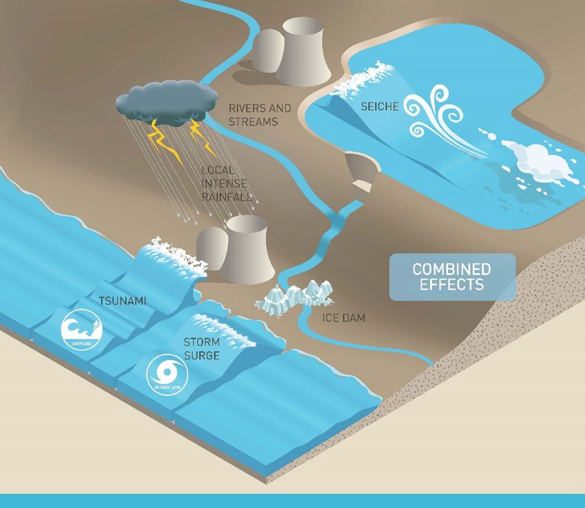
beyond-design-basis events. One of the external flooding hazards that can impact a site is a storm surge –
the elevation in water level at the shore due to the atmospheric effects of a large storm.
Many storm surge methods and analyses are focused on assessing the flooding impacts from a tropical
storm making landfall; however, other types of storms can also cause storm surges, and these events can
occur on large lakes as well as oceans. EPRI has published a technical report, Probabilistic Flooding Hazard
Assessment for Storm Surge with an Example Based on Historical Water Levels, EPRI ID 3002008111.
http://www.epri.com/abstracts/Pages/ProductAbstract.aspx?ProductId=000000003002008111
The report describes multiple methods for performing a PSSHA; however, the detailed example is based
on the assessment of a storm surge at an inland lake site based on historical water levels and wave heights.
The process of performing a PSSHA begins with identification that a site is potentially subject to a storm
surge. The PSSHA then utilizes a qualitative or quantitative screening approach to determine if the hazard
can be screened out form further consideration. If the hazard cannot be screened, a probabilistic approach
is used to determine the frequency of the storm surge flooding parameters (e.g., water level). At each step
in the process, the uncertainty in the analysis is considered and characterized. The PSSHA process includes
the use of a peer review to provide an independent assessment of the process and decisions made in the
analysis.
The report includes an example that uses historical information to assess the probability that a storm surge
on one of the Great Lakes could impact a particular site. The historical data was used to determine the lake
level, surge level, and wave heights. Additional evidence from paleo data was used to extend the historical
record for lake level. This information was used to determine probabilistic distribution functions (PDFs)
for the parameters of interest. These PDFs were used in a Monte Carlo Simulation to estimate the storm
surge-frequency hazard curve for the site. This hazard curve provides the likelihood that a particular flood
level at the site would be exceeded by a storm surge per year. This information can then be used to develop
a probabilistic risk assessment (PRA) model to determine the core damage frequency, large early release
frequency, or other metrics.
2nd Annual Probabilistic Flood Hazard Assessment Research Workshop
U.S. NRC Headquarters, Rockville, Maryland, January 23-25, 2017 Page 9 of 272nd Annual Probabilistic Flood Hazard
Assessment Research Workshop
Rockville, Maryland, January 23-25, 2017
Session 2A: Climate and Precipitation
Regional Climate Change Projections: Potential Impacts to Nuclear 2A-1
Facilities
L. Ruby Leung^, Rajiv Prasad*, Lance Vail
Pacific Northwest National Laboratory
This research project is part of the U.S. Nuclear Regulatory Commission’s (NRC’s) Probabilistic Flood
Hazard Assessment (PFHA) research plan in support of developing a risk-informed licensing framework
for flood hazards and design standards at proposed new facilities and significance determination tools for
evaluating potential deficiencies related to flood protection at operating facilities. The PFHA plan aims to
build upon recent advances in deterministic, probabilistic, and statistical modeling of extreme precipitation
events to develop regulatory tools and guidance for NRC staff with regard to PFHA for nuclear facilities.
An improved understanding of large-scale climate pattern changes such as changes in the occurrence of
extreme precipitation, flood/drought, storm surge, and severe weather events can help inform the
probabilistic characterization of extreme events for NRC’s safety reviews. This project provides a literature
review, focusing on recent studies that improve understanding of the mechanisms of how the climate
parameters relevant to the NRC may change in a warmer climate, including discussions of the robust and
uncertain aspects of the changes and future directions for reducing uncertainty in projecting those changes.
The current focus is on the southeast region consisting of 11 southeastern states in the conterminous U.S.
Except for Kentucky, all states have currently operating nuclear power plants. New nuclear power reactor
permit and license applications submitted to the NRC in the recent past were for sites located in several of
the southeastern states (Virginia, North Carolina, South Carolina, and Florida).
The literature review includes an overview of the climate of Southeast U.S., focusing on temperature and
precipitation extremes, floods and droughts, strong winds (hurricanes and tornadoes), sea level rise and
storm surge. The southeast region occasionally experiences extreme heat during summer and extreme cold
during winter. Floods can be produced by several mechanisms including locally heavy precipitation, slow-
moving extratropical cyclones during the cool season, tropical cyclones during summer and fall, late spring
rainfall on snowpack, storm surge near coastal areas from hurricanes, and occasional large releases from
upstream dams. Hurricanes cause major economic lost but also contribute significantly to the region’s
rainfall. Combined with sea level rise, hurricanes pose significant threats to storm surge and inland
inundation. The report is followed by discussions of projected changes in the aforementioned climatic
aspects. For example, depending on the future emission scenarios, seasonal precipitation shows moderate
increases to significant decreases in magnitude. Very heavy precipitation events are projected to increase
in frequency, while annual maximum precipitation is expected to increase in magnitude. Although
precipitation intensity generally scales with the Clausius-Clapeyron rate of 7% per degree warming,
precipitation intensity decreases at higher temperatures because of the transition to a moisture-limited
environment. Besides climate change, urbanization and changing land use may result in changes in runoff
and flooding. On the contrary, both short-term and longer-term droughts are expected to intensify in the
Southeast. Streamflow is expected to decline as evapotranspiration generally increases with warmer
temperatures. Urbanization and population growth may increase stress on water supplies. As sea surface
2nd Annual Probabilistic Flood Hazard Assessment Research Workshop
U.S. NRC Headquarters, Rockville, Maryland, January 23-25, 2017 Page 10 of 272nd Annual Probabilistic Flood Hazard
Assessment Research Workshop
Rockville, Maryland, January 23-25, 2017
temperatures increase in the future, hurricanes are projected to intensify as the thermodynamical
environments for major hurricanes become more favorable. With sea level projected to rise and more
intense hurricanes, there is increased probability for storm surge along the southeast coastline. Lastly, a
current assessment of climate modeling and federal agency activities related to climate change will be
presented.
Numerical Modeling of Local Intense Precipitation Processes 2A-2
M.L. Kavvas*, K. Ishida* and M. Mure-Ravaud*
Hydrologic Research Laboratory, Dept. of Civil & Envr. Engineering, Univ. of California, Davis
As population and infrastructure continue to increase, our society has become more vulnerable to extreme
events. A flood is an example of a hydro-meteorological disaster that has a strong societal impact. Tropical
Cyclones and Mesoscale Convective Systems are recognized for their ability to generate intense
precipitation that may in turn create disastrous floods. Tropical Cyclones are intense atmospheric vortices
that form over the warm tropical oceans, while Mesoscale Convective Systems are organized collections of
several cumulonimbus clouds which interact at the meso-scale (regional-scale) to form an extensive and
nearly contiguous region of precipitation.
In this study, we assessed the suitability of a regional numerical weather model to simulate local intense
precipitation processes within intense Tropical Cyclones and Mesoscale Convective Systems. More
specifically, we used the Weather Research and Forecasting (WRF) model at 5-km resolution in order to
reconstruct the intense precipitation fields associated with several historical Tropical Cyclones and
Mesoscale Convective Systems which affected the United States. The WRF model was run in the simulation
mode, which means that it was only subject to the influence of its initial and boundary conditions, and no
observation was used to improve the simulations through nudging or other data assimilation techniques.
Numerous studies have shown that regional numerical weather models perform relatively well in
reconstructing such storms in the forecasting mode where such techniques are used to improve the model’s
performances. However, in the context of climate change where one may be interested in simulating the
storms of the future, it is important to evaluate the performances of regional numerical weather models in
the simulation mode, since no observation is available for the future which would allow using nudging or
data assimilation. The storm systems that we simulated were selected within the time period from 2002 to
present, based on the NCEP Stage-IV precipitation dataset, which is a mosaic of regional multi-sensor
analysis generated by National Weather Service River Forecast Centers (RFCs) since 2002. These storms
correspond to the most severe storms, in terms of the generation of an intense precipitation field containing
pockets of extreme rainfall.
The initial and boundary conditions for our simulations were obtained from the Climate Forecast System
Reanalysis (CFSR) dataset, which is provided by National Centers for Environmental Prediction (NCEP)
at 0.5 x 0.5 degree spatial resolution and 6-hour temporal resolution. For the simulations of the Mesoscale
Convective Systems, the model’s simulation nested domains were set up over a region in the Midwest so
that the innermost domain covered the severe precipitation areas caused by these storm systems. However,
several sets of simulation nested domains were prepared for the simulations of the Tropical Cyclones
2nd Annual Probabilistic Flood Hazard Assessment Research Workshop
U.S. NRC Headquarters, Rockville, Maryland, January 23-25, 2017 Page 11 of 272nd Annual Probabilistic Flood Hazard
Assessment Research Workshop
Rockville, Maryland, January 23-25, 2017
because of the diversity in the paths of these systems. More precisely, while the outer domain was the same
for all cases and was chosen so as to cover the paths of all the identified severe Tropical Cyclones, different
inner domains were set up so as to include the severe precipitation areas caused by each individual Tropical
Cyclone. With these sets of simulation nested domains, the WRF model was configured to obtain the best
results for the simulation of each of the selected severe Mesoscale Convective Systems and Tropical
Cyclones storm events with respect to the simulated and observed precipitation fields.
We compared the simulations results with observations from the Stage IV precipitation dataset. More
precisely, on the one hand, the simulation results were evaluated by means of several goodness-of-fit
statistics: the relative error for the simulation inner-domain total precipitation, and the percentage of
overlapping between the simulated and observed fields for several precipitation thresholds. On the other
hand, the simulated and observed precipitation fields were plotted so as to visually appreciate the
similarities and differences in the fields’ texture and structure. We showed that under an appropriate choice
of the model’s options and boundary conditions, the WRF model provided satisfactory results in
reproducing the location, intensity, and texture of the intense precipitation fields in the historical Tropical
Cyclones and Mesoscale Convective Systems. The model’s options that we investigated include the
parameterization schemes such as microphysics, cumulus parameterization, planetary boundary layer
physics, long wave and short wave radiation physics, etc., the vertical resolution (number of layers), the
initial date for the simulation, the time step, and other options related to the physics and dynamics. Although
certain combinations of the parameterization schemes provided in each case realistic results in terms of the
precipitation fields’ textures and structures, placing these fields in the correct spatial locations required
additional efforts, so that the best set of the model’s options varies from one storm system to the other.
Extreme Precipitation Frequency Estimates for Orographic Regions 2A-3
A. Verdin*, K. Holman, and D. Keeney
Flood Hydrology and Meteorology Group, Technical Services Center,
U.S. Bureau of Reclamation
We present an update to the research project “Phase II: Research to Develop Guidance on Extreme
Precipitation Frequency Estimates for the Tennessee Valley.” The focus of this presentation is the use of
sophisticated statistical techniques for identifying homogeneous regions within greater orographic domains
and the subsequent fitting of extreme value distributions for point-scale return level estimates of
precipitation within each homogeneous region. Identification of homogeneous regions is essential for
regional frequency analysis. Regional analyses are based on the assumption that data from stations within
each homogeneous region come from the same theoretical distribution, which is a common method of
extending environmental datasets. Parameter estimation is sensitive to a number of influential factors, the
period of record being one of the most important. It is essential, then, to strengthen the parameter estimates
by substituting “space for time.” We discuss the Self Organizing Maps (SOM) algorithm, a widely used
method of identifying homogeneous regions, and our application of the SOM algorithm to the Tennessee
River Valley. Results from the SOM algorithm are consistent with subjective methods of regionalization.
For each homogeneous region, we apply two distinct methods of regional frequency analysis for estimating
the extreme value distribution parameters of the regional growth curve: L-Moments and Bayesian. The
2nd Annual Probabilistic Flood Hazard Assessment Research Workshop
U.S. NRC Headquarters, Rockville, Maryland, January 23-25, 2017 Page 12 of 272nd Annual Probabilistic Flood Hazard
Assessment Research Workshop
Rockville, Maryland, January 23-25, 2017
regional growth curve for each homogeneous region is produced using scaled annual maximum
precipitation data. Subsequently, a point-scale return level is estimated by scaling the regional growth curve
by the at-site mean of the location of interest. However, it may be of interest to estimate precipitation
magnitudes at locations where no historical observations exist. To this end, we illustrate the benefit of
using gridded reanalyses as input to regional frequency analysis. Specifically, the Newman et al. (2015)
dataset offers an ensemble of gridded daily precipitation for 33 years. The ensemble contains 100 members,
each of which are equally plausible precipitation totals for the grid cell of interest. Similar to the
identification of homogeneous regions, we assume that all ensemble members come from the same
theoretical distribution, which extends the period of record by two orders of magnitude. We illustrate how
the ensemble members may be collapsed into a single dataset, and the extreme value distribution parameters
are estimated independently at each grid cell. We discuss differences in the inherent assumptions and
resulting differences in the two methods. This presentation ends with an illustration of the two methods’
abilities in quantifying small exceedance probability precipitation events with associated uncertainty.
Local Intense Precipitation Frequency Studies 2A-4
John Weglian*
EPRI
To ensure that nuclear power plants are adequately protected against extreme rainfall plant design has
traditionally relied on deterministic requirements to define the extent of flooding that might need to be
accommodated. For purposes of probabilistic risk assessment (PRA), a more comprehensive understanding
of the relationship between the frequency and amount of extreme rainfall is necessary. Such an
understanding is also needed to provide further perspective on the challenges posed by precipitation
corresponding to the deterministic criteria.
To explore the state of the technology and data available to support a more comprehensive probabilistic
evaluation, EPRI undertook an evaluation of the precipitation-frequency relationship for two sites in the
United States, one an inland site and the other an Atlantic Ocean coastal site. The study was primarily based
on regional precipitation-frequency relationships that embody National Weather Service data from a large
number of precipitation measurement stations in the vicinity of the plant sites. The study was published as
Local Precipitation-Frequency Studies: Development of 1-Hour/1-Square Mile Precipitation –Frequency
Relationships for Two Example Nuclear Power Plant Sites, EPRI ID 3002004400.
http://www.epri.com/abstracts/Pages/ProductAbstract.aspx?ProductId=000000003002004400
Plants in the United States are designed to be protected against flooding that could result from local intense
precipitation (LIP). For design purposes, LIP is defined based on precipitation associated with a 1-hour/1-
square mile probable maximum precipitation (PMP) event. The method described in this report was applied
to calculate the probability of the PMP occurring for the two example sites as well.
The approach employed in this report successfully demonstrated the feasibility of a probabilistic technique
for establishing precipitation-frequency relationships for local precipitation events. The regional analyses
also found that an event corresponding to the 1-hour/1-square mile PMP would result in an extremely large
amount of precipitation and would be extremely rare.
2nd Annual Probabilistic Flood Hazard Assessment Research Workshop
U.S. NRC Headquarters, Rockville, Maryland, January 23-25, 2017 Page 13 of 272nd Annual Probabilistic Flood Hazard
Assessment Research Workshop
Rockville, Maryland, January 23-25, 2017
Session 2B: Leveraging Available Flood Information
Development of Flood Hazard Information Digests for Operating NPP sites 2B-1
Dr. Curtis Smith*, Kellie Kvarfordt
Idaho National Laboratory
The objective of the Development of Flood Hazard Information Digests for Operating NPP sites project is
for Idaho National Laboratory (INL) to develop and demonstrate a database architecture for a Flood Hazard
Information Digest to facilitate gathering, organizing, and presenting a variety of flood hazard data sources.
Additionally, INL is assisting in the population of the digests.
The objective of the Development of Flood Hazard Information Digests for Operating NPP sites project is
for Idaho National Laboratory (INL) to develop and demonstrate a database architecture for a Flood Hazard
Information Digest to facilitate gathering, organizing, and presenting a variety of flood hazard data sources.
Additionally, INL is assisting in the population of the digest.
The goal of the project is to provide information and tools to support external flooding-related activities,
particularly the risk-informed aspects of the Significance Determination Process (SDP). Under the SDP the
use of probabilistic flood hazard information and insights is an important input in the determination for
follow-up inspection actions and resource allocation, and risk-informing of licensing actions. However
NRC staff has had to improvise and only use probabilistic flooding hazard estimates on an ad hoc basis, in
a limited manner, with acknowledged limitations with respect to the technical defensibility of the resulting
estimates.
A particular challenge in developing probabilistic flooding hazard estimates within the SDP is that the
required flood hazard information is not readily accessible. It is challenging for NRC staff to assemble and
analyze the information within the time available for the SDP. Thus there is a need to better organize
flooding information at operating reactor sites and improve its accessibility for NRC staff performing SDP
analyses. The Flood Hazard Information Digest application has been developed to address these needs.
The following major data sources have been identified and targeted for inclusion in the Flood Hazard
Information Digest:
• flood hazard information, including flood protection and mitigation strategies, available from
sources that include NUREGs, FSARs, IPEEE submittals, and SDP analyses
• Fukushima NTTF Recommendations
o 2.1 Flood Hazard Reevaluation submittals,
o 2.3 walk down submittals
• available precipitation frequency information from NOAA Atlas 14 database
• available flood frequency information from USGS databases
• available information for hurricane landfall/intensity along US coastal areas
In addition to providing access to these and other data sources, the flood digest must provide, where needed,
guidance for using the available information.
2nd Annual Probabilistic Flood Hazard Assessment Research Workshop
U.S. NRC Headquarters, Rockville, Maryland, January 23-25, 2017 Page 14 of 272nd Annual Probabilistic Flood Hazard
Assessment Research Workshop
Rockville, Maryland, January 23-25, 2017
The Flood Hazard Information Digest has been implemented as a cloud-based web application. The digest
utilizes the INL’s Safety Portal, a system that helps integrate and manage a comprehensive collection of
many different kinds of content including web pages, web applications, models, and documents where users
may store, use, share, modify, or otherwise contribute to projects. The emphasis of the Safety Portal is to
serve as a resource to promote collaboration between producers and users of information. The flood digest
shares available services such as user account management, file sharing, and a publications/ permissions/
subscriptions model.
The Flood Hazard Information Digest application is available to eligible users at
https://safety.inl.gov/flooddigest. New users will be prompted to register for access. Sample data for
selected plants is currently available, and data population efforts for remaining operating NPP sites are
underway. The bulk of data population is targeted for completion by end of this fiscal year. The flood
digest application has been implemented in such a way as to facilitate inclusion of additional external event
hazards if needed.
At-Streamgage Flood Frequency Analyses for Very Low Annual 2B-2
Exceedance Probabilities from a Perspective of Multiple Distributions and
Parameter Estimation Methods
William H. Asquith^
U.S. Geological Survey, Lubbock, Texas
Julie E. Kiang
U.S. Geological Survey, Reston, Virginia
The U.S. Geological Survey (USGS), in cooperation with the U.S. Nuclear Regulatory Commission, is
investigating statistical methods for flood hazard analyses. One task is to provide guidance on very low
annual exceedance probability (AEP) estimation and the quantification of corresponding uncertainties using
streamgage-specific data. The term “very low AEP” implies exceptionally rare events defined as those
having AEPs less than about 0.001 or 10–3 in scientific notation. Such low AEPs are of great interest of
flood frequency analyses for critical infrastructure, such as nuclear power plants. Flood frequency analyses
at streamgages are most commonly based on annual instantaneous peak streamflow data and a probability
distribution fit to these data. The fitted distribution provides a means to extrapolate to small AEPs. Within
the United States, the Pearson type III probability distribution, when fit to the base-10 logarithms of
streamflow is widely used, but other distribution choices exist. The USGS-PeakFQ software implementing
well-known guidelines of Bulletin 17B (method of moments) and pending updates (“Bulletin 17C,” the
expected moments algorithm (EMA) using the Pearson type III) was specially adapted for an “Extended
Output” user option to provide estimates at selected AEPs from 10–3 to 10–6. Parameter estimation methods
in addition to product moments and EMA include L-moments, maximum likelihood, and maximum product
of spacings (maximum spacing estimation). This project comprehensively studies multiple distributions
and parameter estimation methods for two USGS streamgages (01400500 Raritan River at Manville, New
Jersey and 01638500 Potomac River at Point of Rocks, Maryland). The results of this task involving the
four techniques of parameter estimation and up to nine probability distributions including the generalized
extreme value, generalized log-normal, generalized Pareto, and Weibull. Uncertainties in streamflow
2nd Annual Probabilistic Flood Hazard Assessment Research Workshop
U.S. NRC Headquarters, Rockville, Maryland, January 23-25, 2017 Page 15 of 272nd Annual Probabilistic Flood Hazard
Assessment Research Workshop
Rockville, Maryland, January 23-25, 2017
estimates related to AEP are depicted and quantified as two primary forms: quantile (aleatoric [random
sampling] uncertainty) and distribution-choice (epistemic [model] uncertainty). Sampling uncertainties of
a given distribution are relatively straightforward to compute from analytical or Monte Carlo-based
approaches. Distribution-choice uncertainty stems from choices of potentially applicable probability
distributions for which divergence amongst the choices increases as AEP decreases. Conventional
goodness-of-fit statistics, such as Cramér–von Mises, and L-moment ratio diagrams are demonstrated to
hone distribution choice. The results in a generalized sense show that distribution choice uncertainty is
larger than sampling uncertainty for very low AEP values. Future work includes consideration of non-
standard flood data at streamgage locations, regional information, and non-stationarity in flood frequency
analyses.
Extending Frequency Analysis Beyond Current Consensus Limits 2B-3
Joe Wright and Keil Neff*
US Bureau of Reclamation, Technical Service Center, Flood Hydrology & Meteorology
Traditionally, deterministic methods have been used to determine Inflow Design Floods (IDF) based on a
particular loading event to meet regulatory criteria. For infrastructure with high hazard potential, including
nuclear facilities and many large dams, the Probable Maximum Flood (PMF) has often been used as the
IDF. Risk-informed decision-making (RIDM) is currently used by the Bureau of Reclamation, the Army
Corps of Engineers, and other agencies to assess the safety of dams, recommend safety improvements, and
prioritize expenditures. This involves developing estimates of hydrologic hazards to perform probabilistic
risk assessments (PRA). Hydrologic hazard curves provide magnitudes and probabilities for the entire
ranges of peak flow, flood volume, and water surface elevations. There are multiple methods available to
estimate magnitudes and probabilities of extreme flood events; these methods can be generally classified
as streamflow-based statistical analyses or rainfall-based with statistical analyses of the modeled runoff.
Method selection is based on the level of detail necessary and site-specific consideration including data
availability, hydrologic complexity, and required level of confidence. This presentation will focus on
describing recommended methods and approaches for extending frequency analysis methods beyond
current consensus limits (Annual Exceedance Probabilities (AEP) greater than 1:105) for both rainfall and
riverine flooding applications.
Session 2C: Leveraging Available Flood Information II
Collection of Paleoflood Evidence 2C-1
John Weglian*
EPRI
In a probabilistic risk assessment (PRA), it is important to estimate the frequency of initiating events (events
that can cause or demand an immediate trip of the reactor). The estimation of this frequency is challenging
2nd Annual Probabilistic Flood Hazard Assessment Research Workshop
U.S. NRC Headquarters, Rockville, Maryland, January 23-25, 2017 Page 16 of 272nd Annual Probabilistic Flood Hazard
Assessment Research Workshop
Rockville, Maryland, January 23-25, 2017
for rare events and particularly so for external hazards like external flooding, where the historical record is
limited to about one to two hundred years. An external flooding PRA would use a flood hazard frequency
curve that plots
Various techniques are available to extend the data at a particular site including the use of storm
transposition and numerical generation of synthetic storms, but these are still based on data collected in the
recent past. The investigation of paleoflood evidence (evidence of flooding that occurred outside of the
observed record) has the ability to inform the record of actual past flooding events in the region of interest.
In major flooding events, debris and sediment can be suspended and transported long distances in the fast-
moving water. When the water enters a low-flow region, some of the suspended material will sink and
become deposits on the surrounding floor. If these deposits are preserved in the environment, they can be
used to estimate the time of the event and the flood discharge. Paleoflood evidence can be found terrace or
overbank deposits when the water exceeds the riverbank and leaves the deposits on the surrounding land.
These deposits may be good for estimating the frequency of flooding events that exceed that particular
height, but they may not be good at estimating the flood stage for any particular event. Paleoflood evidence
may also be deposited in caves or canyon walls, which could provide a good estimate for the flood stage,
but the topography may be more prone to have one flooding event wash away the evidence of previous
flooding events.
Paleoflood evidence has been used in arid climates with great success, but it was not clear if the same
evidence would be preserved in humid climates. Initial research indicates that paleoflood evidence is
preserved in humid environments, but extracting the data may be more challenging than in arid
environments.
Paleofloods On The Tennessee River - Assessing The Feasibility Of 2C-2
Employing Geologic Records Of Past Floods For Improved Flood
Frequency Analysis
Tess Harden* – USGS Oregon Water Science Center, Portland, Oregon
Jim O’Connor* – USGS, GMEG, Portland, Oregon
Our 2015 field survey and stratigraphic analysis, coupled with geochronologic techniques, indicate a rich
history of large Tennessee River floods is preserved in the Tennessee River Gorge area. Deposits of flood
sediment from the 1867 peak discharge of record (460,000 ft3/s at Chattanooga, Tennessee) appear to be
preserved at many locations throughout the study area. Small exposures at two boulder overhangs reveal
evidence of three to four earlier floods similar in size or larger than the 1867 flood in the last 3,000 years,
one possibly more than 50 percent larger. Flood deposits are also preserved in stratigraphic sections at the
mouth of the gorge at Williams Island and near Eaves Ferry about 70 miles upstream from the gorge. These
stratigraphic records may extend as far back as ~9,000 years, preserving a long history of Tennessee River
floods. Although more evidence is needed to confirm these findings, it is clear that a more in-depth
comprehensive paleoflood study is feasible for the Tennessee River. This study also lends confidence to
the feasibility of successful comprehensive paleoflood studies in other basins in the eastern U.S.
2nd Annual Probabilistic Flood Hazard Assessment Research Workshop
U.S. NRC Headquarters, Rockville, Maryland, January 23-25, 2017 Page 17 of 272nd Annual Probabilistic Flood Hazard
Assessment Research Workshop
Rockville, Maryland, January 23-25, 2017
Session 2D: Reliability of Flood Protection and Plant Response to
Flooding Events I
EPRI Flood Protection Project Status 2D-1
David Ziebell and John Weglian*
EPRI
EPRI is actively helping nuclear electric generating companies manage the risk of external flooding by
providing good technical practices where needed. The Flood Protection Systems Guide was published in
November 2015 (EPRI ID 3002005423) that describes flood-protection components at nuclear power plants
(NPPs) and the design, testing, inspection, and maintenance of these components. This presentation
highlights some of the information provided in that EPRI guide, and describes a follow-on R&D effort to
identify and communicate good practices in maintaining an external flooding design / licensing basis.
These guides are based on information collected from a consensus of industry peers. EPRI’s members have
asked for information to assist in the development and management of their flood-protection basis
requirements in regard to external flooding-related events.
The published guideline gives specific attention to flood barrier penetration seals (FBPSs) because of the
relative complexity, varying designs, and lack of existing codes and standards for these components.
Although the focus of the guide is on external flooding-related events, this guide provides descriptions of
components, design considerations, maintenance activities, and other topics that can apply to both external
and internal flood-protection requirements are included. Additional sections within the guide address
recent industry events and major considerations for establishing and managing flood-basis requirements at
the site level.
The design / licensing basis guide now being developed is based on a detailed survey of design and
management practices regarding maintaining adequate basis for operability of external flood-protection
components at NPPs. This presentation describes the survey approach and summarize current status of the
results being analyzed. In addition, this presentation describes the planned report outline, which constitutes
current views as to the kinds of management elements needed for a NPP owner to effectively manage the
risk of external flooding.
Examples of key elements to be described in the guide include:
Design
Qualification
Maintenance
Design Change Process
Inspection
Periodic Surveillance of Flood Protection Features
Mitigating Strategies for off-normal conditions
2nd Annual Probabilistic Flood Hazard Assessment Research Workshop
U.S. NRC Headquarters, Rockville, Maryland, January 23-25, 2017 Page 18 of 272nd Annual Probabilistic Flood Hazard
Assessment Research Workshop
Rockville, Maryland, January 23-25, 2017
Training
Reevaluations of the adequacy of management methods
Integrated Assessment
Documentation and Reporting
Performance of Flood-Rated Penetration Seals 2D-2
William (Mark) Cummings*
Fire Risk Management, Inc.
Overall risk analyses of nuclear power plants (NPPs) include the need for protection against potential
flooding events; both internal and external events. Typically, a primary method used to mitigate the effects
of a flooding event is the implementation of flood rated barriers that isolate areas of the plant from the
intrusion or spread of flood waters. Any penetrations through flood-rated barriers to facilitate piping,
cabling, etc. must be properly protected to maintain the flood-resistance of the barrier. Numerous types
and configurations of seal assemblies and materials are being used at NPPs to protect penetrations in flood-
rated barriers. However, no standardized methods or testing protocols exist to evaluate, verify, or quantify
the performance of these, or any newly installed, flood seal assemblies. The NRC has implemented a
research program to develop a set of standard testing procedures that will be used to evaluate and quantify
the performance of any penetration seal assembly that is, or will be, installed in flood rated barriers. This
presentation provides a status of that research project, along with outlining plans to perform flood testing
on candidate seal assemblies. This testing will evaluate the ability of the procedures to adequately address
and record the various performance parameters of individual seal assemblies/materials. The results of this
research program may be used in the evaluation of a seal assembly/material and whether it is acceptable for
protecting penetrations in flood-rated barriers.
2nd Annual Probabilistic Flood Hazard Assessment Research Workshop
U.S. NRC Headquarters, Rockville, Maryland, January 23-25, 2017 Page 19 of 272nd Annual Probabilistic Flood Hazard
Assessment Research Workshop
Rockville, Maryland, January 23-25, 2017
Session 3A: Reliability of Flood Protection and Plant Response to
Flooding Events II
Effects of Environmental Factors on Manual Actions for Flood Protection 3A-1
and Mitigation at Nuclear Power Plants
Rajiv Prasad*, Garill Coles^, Angela Dalton^, and Nancy Kohn
Pacific Northwest National Laboratory
Kristi Branch and Alvah Bittner
Bittner and Associates
Scott Taylor
Batelle Columbus
Following the Fukushima nuclear accident, the U.S. Nuclear Regulatory Commission (NRC) identified the
need to ensure the manual actions for flood protection and mitigation (FPM) at nuclear power plants (NPPs)
are both feasible and reliable. Environmental factors and conditions associated with floods that trigger
manual actions for FPM can adversely affect the operators’ ability to perform these actions. In 1994, a
study (Echeverria et al., 1994 or NUREG/CR-5680) reviewed available research on the impacts of
environmental conditions (ECs) on human performance. The current research is part of the NRC’s
Probabilistic Flood Hazard Assessment (PFHA) research plan in support of developing a risk-informed
licensing framework. It aims to apply the lessons learned from NUREG/CR-5680 and more recent research
on how ECs affect human performance for actions similar to NPP FPM manual actions. The first year of
the project focused on characterizing manual actions from available NPP FPMs, developing a conceptual
framework for assessment of impacts of ECs on human performance, characterizing ECs that are expected
to be associated with floods that may trigger NPP FPM procedures, and reviewing the research literature
related to effects of ECs on human performance. In the second year of the current research, we have
continued to refine the conceptual framework, complete the review of more recently available literature,
and propose a proof-of-concept method for application of the available information within the conceptual
framework.
The conceptual framework represents FPM procedure as a set of manual actions, tasks and subtasks, generic
actions (GAs), and performance demands (PDs). A manual action is a distinct group of inter-related tasks
that are performed outside the main control room to achieve an operational goal. A task is one step of a
manual action that has a distinct outcome or pre-determined objective contributing to accomplishment of
the manual action. A task generally requires both motor and cognitive abilities. Several subtasks may
comprise a task. A GA is an individual component of a task or subtask that is sufficiently simple to evaluate
impact of ECs on human performance. Successful completion of a GA may require several PDs, which are
human abilities including cognitive, motor, and communication. We developed the PDs from three sources:
NUREG/CR-5680 performance abilities, O’Brien et al. (1992) task taxonomy, and NUREG-2114 cognitive
functions. Our proposed PDs include (1) detection and noticing, (2) understanding, (3) decision-making,
(4) action, and (5) teamwork. The PD “action” is further subdivided into fine motor and coarse motor skills
2nd Annual Probabilistic Flood Hazard Assessment Research Workshop
U.S. NRC Headquarters, Rockville, Maryland, January 23-25, 2017 Page 20 of 272nd Annual Probabilistic Flood Hazard
Assessment Research Workshop
Rockville, Maryland, January 23-25, 2017
and the PD “teamwork” is further subdivided into (a) reading and writing, (b) oral communication, and (c)
crew interaction.
We structured our literature review to integrate the most recent research information with that assembled
in NUREG/CR-5680, address ECs that had not been covered in that review, and to present the findings in
a format that is most useful for those reviewing and assessing performance impacts from the range and
combinations of tasks, GAs, and PDs pertinent to outdoor work in varying weather conditions. Because
we were reviewing literature that represented a wide range of methods, objectives, variables, and rigor, we
also provide an overview of the state of the literature on performance effects on a range of ECs that include
those associated with extreme weather conditions.
Using an example, we describe a proof-of-concept method to demonstrate how impacts can be assessed on
a task that is part of a FPM procedure taken from a real NPP. Research on ECs’ impacts in literature is
available in four categories: (1) quantitative information that is directly applicable, (2) quantitative
information that is less directly applicable, (3) qualitative information that may be used to inform expert
judgments or sensitivity analyses, and (4) no information, i.e., a research gap. We note that the proof-of-
concept method as illustrated by the example has limitations that need to be addressed. Finally, we present
potential future research topics that will further improve upon our conceptual framework and facilitate
application of the framework to evaluation of FPM manual actions at operating NPPs.
References
Echeverria, D., V. Barnes, A. Bittner, N. Durbin, J. Fawcett-Long, C. Moore, A. Slavich, B. Terrill, C.
Westra, D. Wieringa, R. Wilson, D. Draper, D. Morisseau, J. Persensky. 1994. The Impact of
Environmental Conditions on Human Performance: A Handbook of Environmental Exposure.
NUREG/CR-5680 Vol. 1 and 2; PNL-7675. Pacific Northwest Laboratory, Seattle, WA.
O’Brien, L. H., Simon, R., and H. Swaminathan. 1992. Development of the Personnel-Based System
Evaluation Aid (PER-SEVAL) Performance Shaping Functions. United States Army Research Institute for
the Behavioral and Social Sciences.
Whaley, A., Xing, J., Boring, R., Hendrickson, S., Joe, J., Le Blanc, K., and Morrow, S. 2015. Cognitive
basis for human reliability analysis. NUREG-2114. Nuclear Regulatory Commission (NRC) Office of
Nuclear Regulatory Research, Washington D.C.
2nd Annual Probabilistic Flood Hazard Assessment Research Workshop
U.S. NRC Headquarters, Rockville, Maryland, January 23-25, 2017 Page 21 of 27You can also read