PRODUCTS FOR VOLCANIC CLOUD MONITORING - Corradini S., Merucci L., Guerrieri L., Stelitano D. Pardini F., Costa A., De Michieli Vitturi M. ...
←
→
Page content transcription
If your browser does not render page correctly, please read the page content below

PRODUCTS FOR VOLCANIC CLOUD
MONITORING
Corradini S., Merucci L., Guerrieri L., Stelitano D.
Pardini F., Costa A., De Michieli Vitturi M., Esposti Ongaro T., Macedonio G., Neri A.
• (BRIEF) INTRODUCTION
                                         Merge of 3 Modules

        Merucci L., et al.                 Corradini S., et al.                 Pardini F., et al.

Stima dell'altezza della nube       Produzione di mappe di cenere      Sviluppo una procedura di Data-
vulcanica.                          (massa, spessore ottico e raggio   Assimilation (DA) volta a
Sistema di acquisizione di dati     effettivo delle particelle) ed     migliorare le previsioni
satellitari multimissione MAST      SO2 (massa) presente nelle nubi    numeriche del trasporto e
(Multimission Acquisition           vulcaniche, utilizzando            dispersione di cenere e SO2
SysTem) installato presso la sede   strumentazione satellitare         prodotti da eruzioni vulcaniche
INGV di Roma dal 2018 per           geostazionaria (SEVIRI) e          utilizzando osservazioni
acquisizione e processamento        polare (MODIS, SLSTR).             satellitari acquisite in real-time
dati satellitari in tempo quasi                                        durante l’eruzione.
reale (NRT).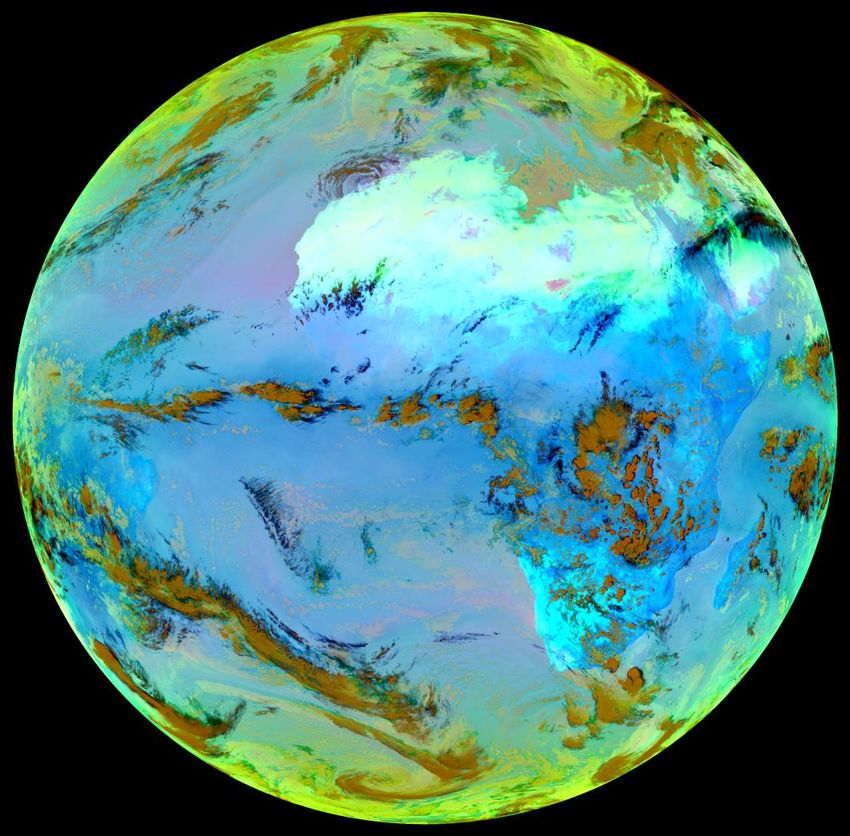
• SCIENTIFIC RATIONALE
      Geostationary satellites                                   Polar satellites
                                                                                                            SO2 retrievals:
                                                                                                           λ ~ 7.3, 8.6 μm

                                                                                                         Ash/VCTH retrievals:
                                                                                                           λ ~ 11, 12 μm

   Low spatial resolution, High temporal resolution   High spatial resolution, Low temporal resolution     All measurements
                                                                                                           in the TIR spectral
   GEO - SEVIRI                                       LEO - MODIS
   27/12/18 - 12:15 UTC                               27/12/18 - 12:20 UTC
                                                                                                                  range

                                                                                                           Monitoring during
                                                                                                            day and night

                                    288 images                                           4 images
                                      per day                                             per day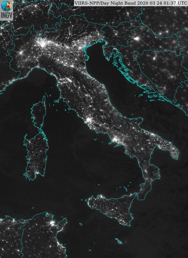
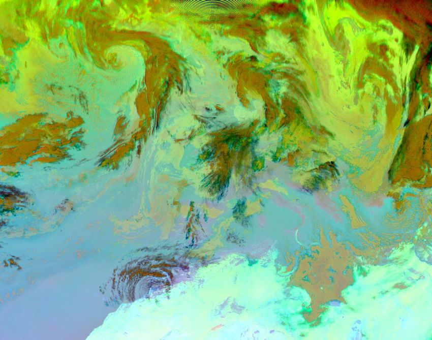
• SCIENTIFIC RATIONALE - SO2/Ice/Ash Detection e Retrievals
RGB composite:
R: Tb,8.7 – Tb,10.8 ;
G: Tb,12 – Tb,10.8 ;
B: Tb,10.8
• SCIENTIFIC RATIONALE - SO2/Ice/Ash Detection e Retrievals
                                                    RGB composite:
                                                           R: Tb,8.7 – Tb,10.8 ;
                                                           G: Tb,12 – Tb,10.8 ;
                                                           B: Tb,10.8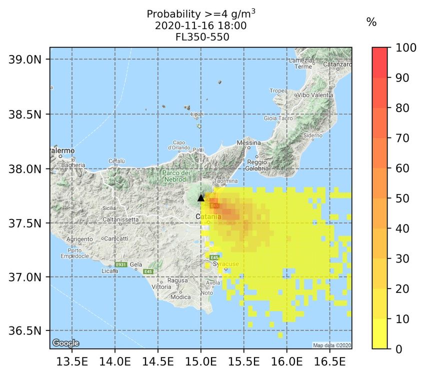
•   SCIENTIFIC RATIONALE -Volcanic Plume Top Height
     24 Dec. 2018 12:00 UTC                           Darkest pixels procedure
         Tb @ 10.8 mm

                                             VPTH          The volcanic cloud altitude is obtained
                                                           by comparing the satellite image
                                                           ‘darkest pixels’ Tb,11, with the
                                                           atmospheric temperature profile of the
                                                VCTH
                                                           area of interest [Prata and Grant, 2001]

                       -30
                        oC

                              7.7
                              km

                                                                    Corradini et al., 2020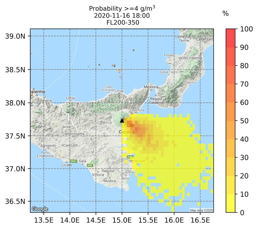
Soufriere (San Vincent), SLSTR, April, 2021
• SCIENTIFIC RATIONALE -Volcanic Ash/SO2 Retrievals
Look Up Table (LUTp) Volcanic Plume Retrieval (VPR)
Ash Raikoke, SLSTR,
[Prata, 1989; Wen and Rose, 1994] [Pugnaghi et al., 2013; 2016; Guerrieri et al., 2015]
22 June 2019, 00:07 UTC Throught interpolation at the volcanic cloud edges, computation of the
Exploiting the LUT computed using RTM
SLSTR image without volcanic cloud signal and, considering a simplified
Ash Mass atmospheric model, the 11 and 12 mm transmittances
Total Mass:
0.41 +/- 0.16 Mt
SO2
Anak Krakatau, SLSTR,
23 Dec. 2018, 02:57 UTC Inputs
Surface temperature and emissivity
Ice Mass Cloud altitude and thickness Inputs
Particles type (Ash, Ice, Wvp) Cloud altitude
Atmospheric profiles (P, T, H)
Total Mass:
Advantages
2.07 +/- 0.83 Mt Advantages The volcanic cloud altitude is the only input parameter
Precise characterization of the surface and the atmosphere Real time processing
Drawbacks Drawbacks
Need of atmospheric corrections computation Parameters are characteristics for a specific area and volcano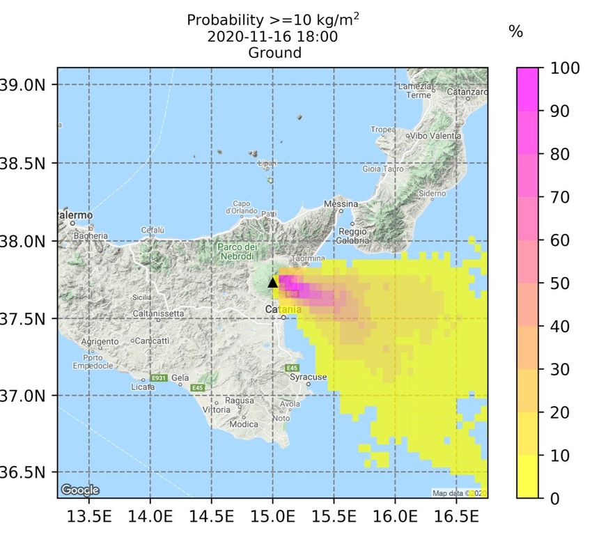
•   SCIENTIFIC RATIONALE - Validation
                                                          Etna, December 2018
                            SO2 Total Mass

                                                                     Ash Total Mass

                              SO2 Flux

                           Corradini et al., 2020; 2021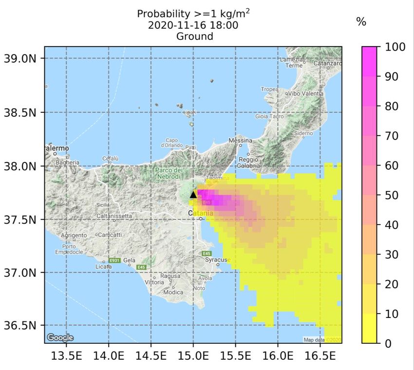
•      SCIENTIFIC RATIONALE - Volcanic ash automated forecasting workflow for Etna
                                                                                               VONA
ARPA-SIM data
                                                               Meteo data                   Satellite data
downloaded every day at 08:00 (00) and 20:00 (12)

Daily forecast      Run every day at 09:00 (and 21:00)                      Real time forecast         Run when RED VONA is released
Continuous emission from 12 UTC (00 UTC) for 6 hours                    1 eruptive scenario
4 simulation cycles starting at 12/18/00/06 (00/06/12/18)               Forecast start hour: h0=hVONA
2 eruptive scenarios: weak and strong                                                         Read input files and VONA
                                                                                            Check for new VONA
Forecast start hour: h0= 12 (00)
                     Read input files                                   Time loop:          Check for satellite data
Time loop:                                                              N cycles            Update eruptive scenario
4 cycles             Initialize ensemble members at h0                  each
each                                                                    from h0             Initialize ensemble members at h0
                     Perform PLUME-MoM/HYSPLIT simulations
from h0              from h0 to hi                                      to                              ,
                                                                                            Perform PLUME-MoM/HYSPLIT simulations
to                                                                      hi=h0+1h            from h0 to hi
hi=h0+6h             Create output files (.res) and images (.png)
                      Mean and variance states of ash CC                                   If satellite data, perform data assimilation at hi
                      Mean and variance states of ground load                                Create output files (.res) and images (.png)
                      Probability maps (ground and air)                                      Mean and variance states of ash CC
                      Mean concentration at different FL (air only)                          Mean and variance states of ground load
                                                                                             Probability maps (ground and air)
                     Upload images on FTP-Server                                             Mean concentration at different FL (Air only)
                     h0=hi                                                                  Upload images on FTP-Server
                                                                                            h0=hi
•       SCIENTIFIC RATIONALE – Simulating Setting
                          Daily forecast                                                      Real-time forecast

    Eruptive scenario   Weak                     Strong                   Eruptive scenario            Vona scenario

    Reference           2001/2002-03 flank       1986 (NEC), 1990
    eruption            eruption.                (SEC), 1998 (VOR).       Column height                from the Vona or uniform pdf 2-8
                        2006 SEC.                (Barsotti et al, 2010)                                km above the vent
                        (Barsotti et al, 2010)

    Column height       uniform pdf 1-4km        uniform pdf 8-13 km      TGSD mu                      gaussian pdf: 2+-1
                        above the vent           above the vent                                        (Scollo et al., 2007)
                        (Barsotti et al, 2010)   (Barsotti et al, 2010)
    TGSD mu             gaussian pdf: 2+-0.5     gaussian pdf: 2.3+-0.5
                        (Scollo et al., 2007)    (Scollo et al., 2008)    TGSD sigma                   gaussian pdf:1.5+-1 (Scollo et
                                                                                                       al., 2007)
    TGSD sigma          gaussian pdf:1.5+-0.5    gaussian pdf:1.5+-0.5
                        (Scollo et al., 2007)    (Scollo et al., 2008)    Meteo data                   ARPA-SIM

    Meteo data          ARPA-SIM                 ARPA-SIM                 Nwind                        10

    Nwind               10                       10
                                                                          Nesp                         15
    Nesp                15                       15
                                                                          N                            150
    N                   150                      150
• SCIENTIFIC RATIONALE - Volcanic ash automated forecasting workflow at Etna RESULTS: Daily forecast run at 09:00 on 16/11/2020 Strong scenario Probability ash maps: ground loading
•      SCIENTIFIC RATIONALE - Volcanic ash automated forecasting workflow at Etna
RESULTS: Daily forecast run at 09:00 on 16/11/2020
Strong scenario              Probability ash maps: atmospheric ash concentration between two flight levels (FL)
•     SCIENTIFIC RATIONALE - Volcanic ash automated forecasting workflow at Etna
RED VONA bulletin issued on 06 January 2021 at 09:51 UTC
RESULTS: Real-time forecast                              Probability ash maps: ground
loading
•     SCIENTIFIC RATIONALE - Volcanic ash automated forecasting workflow at Etna
Data-assimilation of satellite observations of atmospheric ash amount into Volcanic Ash Transport and Dispersal Models
                                                                                                                      (Pardini et al., 2020)

                                                                                  ●   Case study: explosive eruption occurred at
                                                                                      Mt.Etna on 24 December 2018

                                                                                  ●   Ash dispersal is modeled with PLUME-
                                                                                      MoM-TSM and HYSPLIT

                                                                                  ●   Ensemble-based Kalman Filters are
                                                                                      applied to improve numerical forecasts by
                                                                                      assimilating satellite observations of
                                                                                      atmospheric ash amount.

                                                                                  ●   A new assimilated forecast is produced
                                                                                      with minimized uncertainties with respect
                                                                                      to numerical forecast and observations.
• OBSERVATIONAL INFRASTRUCTURE
Reuse of 1.8 m Satellites
Nanometrics antenna, Light Pollution During COVID-19
from seismic stations Receiver DVB
Lockdown Period (March 24, 2020).
(Posta Fibreno-POFI) VIIRS-NPP /Day Night Band
Data reception reliability
99.9% https://ingvambiente.com/2020/03/24/
linquinamento-luminoso-dallo-spazio/
Soon, installation of ta
second antenna for
redundancy
Software for
data
2 redundant servers for data elaboration
acquisition and processing
+ 2 server storage
The MAST acquisition system has
been realized using European
(EU-EVEREST, ESA-VISTA, EU-
RELIANCE), National (FISR,
Pianeta-Dinamico, Ash-resilience,
ATTEMPT) e DPC All.A foundings• OBSERVATIONAL INFRASTRUCTURE: Data Available in Near Real Time
RICEVUTI AD OGGI
RICEVUTI AD OGGI All other Meteorological Products - IODC GOES-East (GOES-16) ABI Level 2 Products
SSMIS All other Meteorological Products//Set 1//Europe/Africa GOES-East (GOES-16) GLM Level 2 Products
RDS-EARS-ASCAT All other Meteorological Products//Set 3//Europe/Africa GOES-East (GOES-16) ABI 10 minute image data
RDS-EARS-ATMS All other Meteorological Products//Set 1//Europe only GOES-East (GOES-16) Space Weather Data
RDS-EARS-ATOVS All other Meteorological Products//Set 1//Global GOES-East (GOES-16) Space Weather EXIS and SUVI products
RDS-EARS-AVHRR All other Meteorological Products//Set 2//Europe/Africa GOES-West (GOES-17) GLM Level 2 Products
RDS-EARS-CrIS RSS Meteosat Meteorological Products GOES-West (GOES-17) ABI 10m image data
RDS-EARS-IASI Level 1 RSS Meteosat Meteorological Products GOES-West (GOES-17) ABI half-hourly image data
RDS-EARS-IASI Level 2
RDS-EARS NWC
RSS SEVIRI Level 1.5 Image Data **
GDS-SNPP/NOAA-20: VIIRS EDR
SEVIRI Himawari-8 10-minute image data
RDS-EARS VASS (Regional FY-3C Sounder Service) MODIS Products: Global Ocean Colour Products RICEVUTI CON L’IMPLEMENTAZIONE
RICEVUTI DELLA
CON L’IMPLEMENTAZIONE DELLA NUOVA NUOVA PARABOLA
PARABOLA
N20 EARS-VIIRS CM SAF Products NOAA-20 Atmospheric Products
GDS-Multi-Metop Wind Products ROM SAF Products S3A OLCI L1B Reduced Resolution NRT
GDS-Metop-B: AMSU-A Level 1 H-SAF Products S3B OLCI L1B Reduced Resolution NRT
GDS-Metop-B: ASCAT L1 Sigma0 at Full Sensor Resolution ** H-SAF Products//Global S3A OLCI L2 Ocean Colour Reduced Resolution
GDS-Metop-B: ASCAT Soil Moisture LSA SAF Products//Africa LSA SAF Products//Europe S3B OLCI L2 Ocean Colour Reduced Resolution
GDS-Metop-B ATOVS Sounding Products LSA SAF Products//Global S5P L2 Aerosol Index
GDS-Metop-B: AVHRR Level 1 LSA SAF Products//Americas S5P L2 Aerosol Layer Height
GDS-Metop-B: AVHRR Polar Winds AC SAF Products//Africa S5P L2 CLOUD Cloud Fraction Albedo top Pressure
GDS-Metop-B: GOME-2 Level 1 ** AC SAF Products//Europe S5P L2 Carbon Monoxide
GDS-Metop-B: GRAS Level 1 OSI SAF Products//Europe S5P L2 HCHO Formaldehyde Total Column
GDS-Metop-B: HIRS Level 1 OSI SAF Products//Global S5P L2 NO2 Nitrogen Dioxide
GDS-Metop-B: IASI Level 1: All Spectral Samples ** UNS-general S5P L2 O3 Ozone Total Column
GDS-Metop-B: IASI Level 1: Principal Component Scores VIIRS Fire Product S5P L2 SO2 Sulphur Dioxide
GDS-Metop-B: IASI Level 1: Reduced Spectral Samples (500 channels) Copernicus Global Land service: Africa S3A SLSTR L2 Aerosol Optical Depth
GDS-Metop-B: IASI Sounding Products//Africa Copernicus Global Land service: South and Central America S3B SLSTR L2 Aerosol Optical Depth
GDS-Metop-B: IASI Sounding Products//Europe NCEP Products S3A SLSTR L2 Fire Radiative Power
GDS-Metop-B: MHS Level 1 RDS-EARS-ATMS S3B SLSTR L2 Fire Radiative Power
GDS-Metop-C: AMSU-A Level 1 RDS-EARS-CrIS S3A SLSTR L2 Sea Surface Temperature NRT
GDS-Metop-C: ASCAT L1 Sigma0 at Full Sensor Resolution **
GDS-Metop-C: AVHRR Level 1
RDS-EARS-VIIRS
GDS-Metop-A: AMSU-A Level 1
VIIRS S3B SLSTR L2 Sea Surface Temperature NRT
SNPP Marine Products
GDS-Metop-C: AVHRR Polar Winds GDS-Metop-A: ASCAT L1 Sigma0 at Full Sensor Resolution ** SNPP Atmospheric Products
GDS-Metop-C: GRAS Level 1 GDS-Metop-A: ASCAT Soil Moisture
GDS-Metop-C: MHS Level 1 GDS-Metop-A: AVHRR Level 1 RICEVUTI
RICEVUTICON L’IMPLEMENTAZIONE
CON L’IMPLEMENTAZIONE DI TERRESTRIAL DI TERRESTRIAL
GDS-Metop-B Polar Multi-sensor Aerosol Product GDS-Metop-A: AVHRR Polar Winds S3A OLCI L1B Full Resolution NRT
GDS-NOAA-19: AMSU-A Level 1 GDS-Metop-A: GOME-2 Level 1 ** S3B OLCI L1B Full Resolution NRT
GDS-NOAA-19: ATOVS Sounding Products GDS-Metop-A: GRAS Level 1 S3A OLCI L2 Ocean Colour Full Resolution NRT
GDS-NOAA-19: AVHRR Level 1 GDS-Metop-A: HIRS Level 1 S3B OLCI L2 Ocean Colour Full Resolution NRT
GDS-NOAA-19: HIRS Level 1 GDS-Metop-A: IASI Level 1: All Spectral Samples ** S5P - Solar Irradiance Measurements - SWIR module
GDS-NOAA-19: MHS Level 1 GDS-Metop-A: IASI Level 1: Principal Component Scores S5P - Consolidated Earth Radiances Measurements
EPS-SERVICE GDS-Metop-A: IASI Level 1: Reduced Spectral Samples (500 channels) S5P - Solar Irradiance Measurements - UVN module
FMI Products GDS-Metop-A: IASI Sounding Products//Africa S5P L2 Aerosol Index
FY-2 GDS-Metop-A: IASI Sounding Products//Europe S5P L2 Aerosol Layer Height
All other Meteorological Products//Set 4//Europe/Africa GDS-Metop-A: MHS Level 1 S5P L2 CLOUD Cloud Fraction Albedo top Pressure
MODIS Products: Thinned Level 1 Products MODIS
0deg SEVIRI Level 1.5 Image Data: 1/4-hourly data transmissions **
GDS-Metop-A: Polar Multi-sensor Aerosol Product
GDS-SNPP/NOAA-20: ATMS SDR
S5P L2 Carbon Monoxide
S5P L2 HCHO Formaldehyde Total Column
0deg SEVIRI Level 1.5 Image Data: 1/2-hourly data transmissions ** GDS-SNPP/NOAA-20: CrIS SDR S5P L2 NO2 Nitrogen Dioxide
0deg SEVIRI Level 1.5 Image Data: 1-hourly data transmissions GDS-SNPP/NOAA-20: ATMS SDR S5P L2 O3 Ozone Total Column
IODC SEVIRI Level 1.5 Image Data: 1/4-hourly data transmissions ** GDS-SNPP/NOAA-20: CrIS SDR S5P L2 SO2 Sulphur Dioxide
IODC SEVIRI Level 1.5 Image Data: 1/2-hourly data transmissions ** Aeolus Level 2 Products S3A SLSTR L1B NRT
IODC SEVIRI Level 1.5 Image Data: 1-hourly data transmissions S3B SLSTR L1B NRT SLSTR• PRODUCTS AVAILABLE
Products Sensors/Models Availability (MAST)
Ash/Ice/SO2 detection maps SEVIRI, MODIS, VIIRS, SLSTR Real Time
Ash/Ice/SO2 retrievals SEVIRI, MODIS, VIIRS, SLSTR On Demand
Ash/Ice/SO2 fluxes SEVIRI, MODIS, VIIRS, SLSTR On Demand
Volcanic cloud (plume) top
SEVIRI, MODIS, VIIRS, SLSTR On Demand
heights
HYSPLIT
Ash hazard forecast maps (on (work in progress: simulations with Daily Forecast /
ground and atmosphere) FALL3D and DA with EO data from space) Real time• CURRENT DISTRIBUTION OF PRODUCTS
Ash hazard forecast maps:
Dedicated Web Page containing all products
(Work in progress)• PROGRAMS/PROJECTS OF REFERENCE
Name Deadline
FP7-Aphorism -
FP7-EVEREST -
European FP7-EUROVOLC 2021
ESA-VISTA 2021
H2020-RELIANCE 2022
FISR -
Ash-resilience 2021
INGV Pianeta-Dinamico 1 (PD1), Task V3 2022
PD2-ATTEMPT 2023
DPC All.A 2020 founding• TEAM AND AFFILIATIONS
Name Affiliation
Corradini Stefano Roma-ONT
Merucci Luca Roma-ONT
Guerrieri Lorenzo Roma-ONT
Stelitano Dario Roma-ONT
Pardini Federica Pisa
Costa Antonio Bologna
De Michieli Vitturi Mattia Pisa
Esposti Ongaro Tomaso Pisa
Macedonio Giovanni Napoli
Neri Augusto PisaThanks for your attention
• INFRASTRUCTURE FOR DATA MANAGEMENT AND PROCESSING
You can also read