Récentes campagnes de mesures atmosphériques par drones
←
→
Page content transcription
If your browser does not render page correctly, please read the page content below
Récentes campagnes de mesures atmosphériques par drones
   Session n°5 : Projets de recherche sur les drones chez les partenaires du GIS Micro-Drones

               Boréal (La Réunion)                                                          Xeno (Cerdagne)

                                                                                                   Xeno

                                               Skywalker X6 (La Réunion)

        G. Roberts, G. Cayez, R. Calmer, S. Barrau, F. Julien, J. Viviand, S. Arixi,
               N. Maury, P. Narvor, F. Burnet, S. Defoy, G. Tabet-Helal

                                                                           Drone Garden Workshop, 7 June 2019
Summary of UAS Flights at CNRM
2019
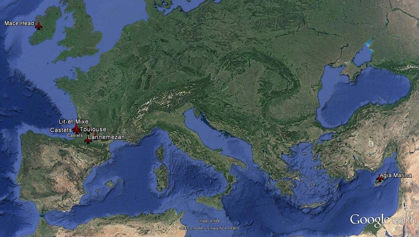
Ireland 2015 2017
2017 Reunion Island
2019
France
2016
2013
2015
2012 Spain
2017 2016 Cyprus
2017 700+ flights / 250+ hours
(2012 – 2019)
• 10 different types of platforms (all fixed-wing)
ISTP Cayez et al. 2
• Weather conditions: winds up to 17 m/s, snow, ice, rain, fog; up to 3350 m.agl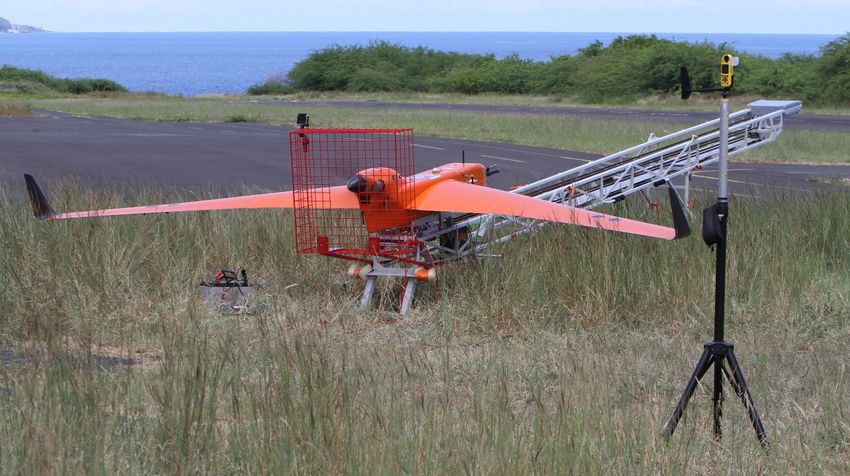
Motivation: atmospheric science
                                            Dust              Ocean
•   Sources and transport of
    aerosols and gases (i.e.,
    sea spray, volcanic
                                                                          Clouds
    eruptions, biomass burning,
    industrial pollution, dust)

•   Aerosol-cloud interactions,
    fog, visibility, health effects
                                                   Volcanos   Pollution
•   In-situ input and validation
                                      Fog             Biomass burning
    of numerical models,
    satellites.
           Process studies and spatial/temporal variability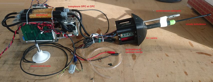
Fire plume flux measurements using UAS
  CRA, Lannemezan (August 2016)

                                                            direction

                                                                                                 Flux (N.cm-2.s-1)
                                  Altitude (m.asl)

                                                              Wind
                                                                Plume

                                                        Direction (degrees)
          UAV
                          Flux (N.m-2.s-1) = Speed (m/s) * Concentration(N/m3)
                                                     Wind (GPS)         Particle Counter (OPC)

   BBQ                   • Cylindrical flight around source (1 hour up to 150
                           m.agl; vertical res. ~5 m; horizontal res. ~15 m)
                         • Measured aerosol concentration and wind vector;
                         • Subtract background to calculate particle flux
                                                               STRAP : Stage – Antoine Hubans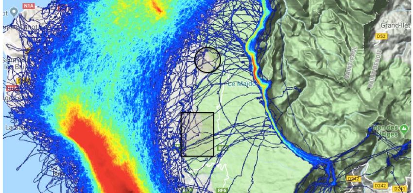
Sea salt emissions – natural aerosol
Annual Sea Salt emissions
Grythe et al., 2014
Different parameterizations
normalized emissions
large discrepancy
(> 8 m s-1)
Partanen et al., 2014
Wind speed (m s-1)
• Parametrizations in models create uncertainties in assessing the role of sea salt
(and consequently anthropogenic aerosol) on Earth’s climate
• Aerosol and energy surface flux measurements needed to improve models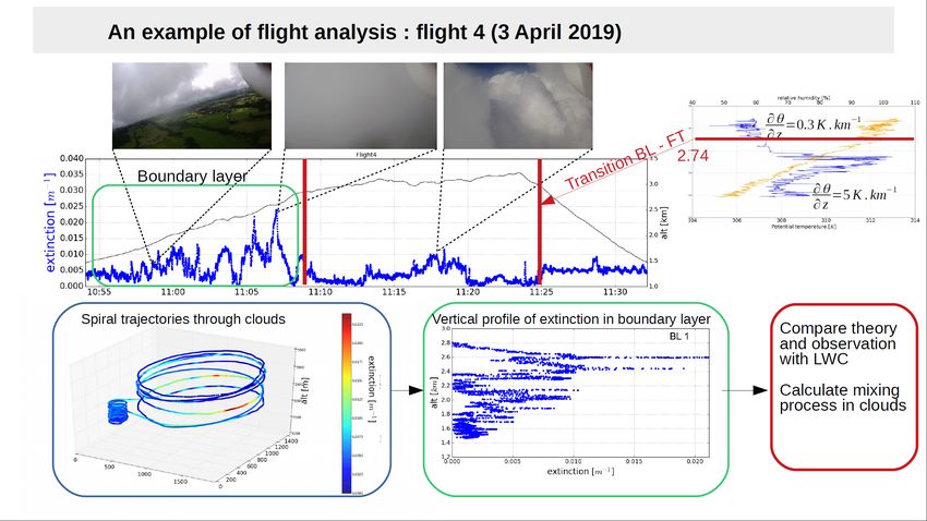
Primary marine aerosol in surf zone
  • Transects across surf zone             Vertical profiles
    (Montalivet, Atlantic coast, France)
  • Spiral vertical profiles from ~ 7 to
    150 m.asl
  • Aerosol size distribution (0.5 < Dp
    < 10 um; RH < 40%), PTU

     Skywalker X6                          Aerosol emissions (surface layer)
                                                                      boundary layer

                                                                        surface layer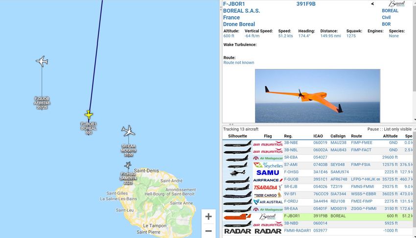
Sea salt emissions (surf zone)
• Steep gradient in aerosol
doi : 10.4267/2042/62453
Roberts et al., La Météorologie,
concentration < 30 m.asl
• Number concentrations (Dp >
0.5 um; red): ~ 200 / cc in
OPC
surface layer; ~ 60 /cc in
boundary layer
• Aerosol mass (black): ~ 1.5 ug /
m3 surface layer; < 0.2 ug / m3
in boundary layer
Flux estimate: F = D (dC / dz)
:: ρ ~ 2 g/cm3; D ~ 10-2 m2 / s
F ~ 1 ng / m2.s (PMA surf zone)
(note: not all mass measured
– see next slide)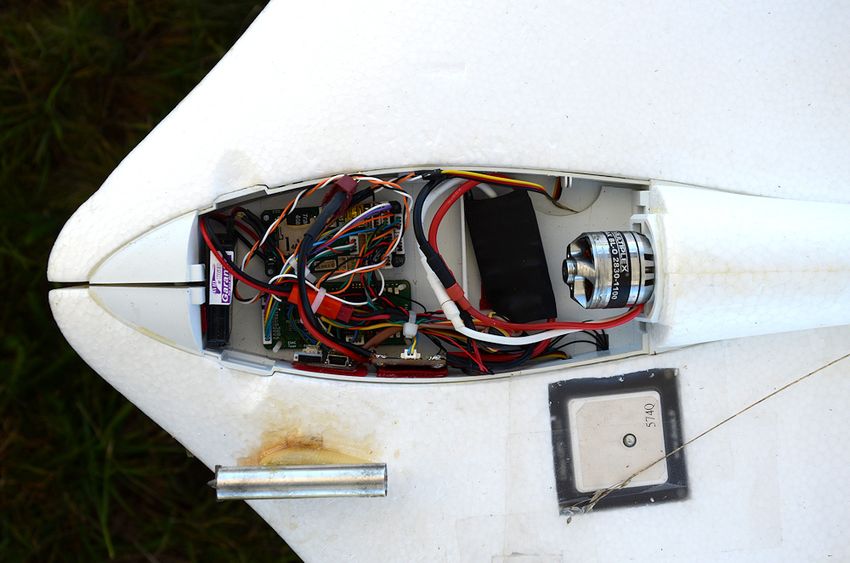
Mission specific science payload
Atmospheric state
Pressure, temperature, humidity boundary layer stability; lifting condensation
level
Wind Speed & Flux
multi-hole probe U, V horizontal wind speed
w vertical wind; eddy flux correlation
Wave Height; Sea State
Radar altimeter Wave height
Video camera White cap fraction
Sea surface temperature (SST)
IR temperature SST kinematic viscocity
Aerosol
Optical Particle Counter Number & mass concentration (Dp > 0.3 um)
Condensation Particle Counter Number concentration (Dp > 10 nm)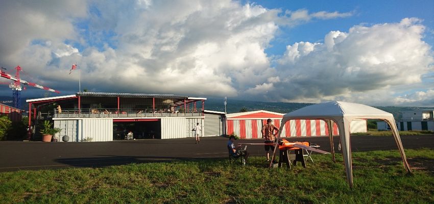
Payload for MIRIAD / ReNovRisk
                   DAQ
           dryer

        particle counters
                                           INS & DAQ

    IR temperature

•   Designed to measure air-sea interactions: Aerosol concentration and size distribution, 3D winds and
    turbulence; sea surface temperature, wave height, solar flux, meteorological state, video

•   Payload data sent to ground-station in real-time for mission planning.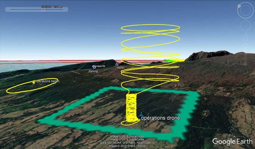
Platform: BOREAL
Specifications:
• Wingspan: 4.2 m; 25 kg max take-off
• Flight capacity up to 700 km with a 5 kg payload
  (ca. 7 hrs)
• Two-stroke gas engine
• 95 km/h cruise air speed (26.4 m/s); Range: 60-
  130 km/h
• Catapult take-off; belly landing
                                                     Onboard instrumentation during ReNovRisk):
                                                     • Transponder (mode S/ADS-B)
                                                     • Strobe
                                                     • C2Link RF communication & Iridium satellite with real-
                                                       time video (up to 50 km from GCS)
                                                     • Radar altimeter to measure sea state and for security
                                                     • Science payload to measure 3D winds, aerosol,
                                                       turbulent fluxes
Objectives and field operations Recent campaigns in February – April 2019 leveraged two research programs: • MIRIAD, with the aim to develop the scientific payload and technical capacity of the Boreal to study air-sea interactions • ReNovRisk, a program to study the impacts of aerosol fluxes on the development of tropical cyclones (in collaboration with the University of La Réunion and LACy). • Flight corridors established to access international airspace from aerodromes on east and west coasts of Reunion Island (Cambaie and Bras Panon) • Restricted airspace extended to 250 km from the operations center with a flight ceiling of 3500 ft (1067 m). • Flight operations conducted by BOREAL (ground-station pilot and a security pilot) • Coordination of BOREAL flights with ATC and other users of the airspace conducted by DroneXSolution. Reunion Island • The CNRM team coordonated scientific and logistical operations.
2019.03.25 – Cyclone Joaninha

MIRIAD / ReNovRisk flights                                         Mauritius
                                                       Reunion
                                                        Island

                             Mauritius                                              http://windy.com

                                          • Flight operations:
                                             • 4 – 19 February; 21 March – 2 April 2019
                                             • ULM Cambaie; ULM Bras Panon (La Réunion)
                Reunion
                                             • 12 research flights; 53.7 hours; 5012 km
                 Island
                                          • Airspace
                                             • 500 km diameter circle
                                             • Surface to 1000 m.asl (w/ corridor to access
                                               international airspace)
                                             • > 25 km from RUN (commercial airport)
  [La France metropole shown for scale]      • Authorization requested for Reunion Island
                                               airspace only.
Flight experience • Average flight duration : 4.5 hours • Three flights farther than 200 km from ground operations (202, 222 and 245 km) • Longest flight lasted 6.3 hours and covered 610 km • Minimum altitude : 40 m.asl • Observations on the perimeter of the Cyclone Joaninha (three flights between 23/03 and 25/03) • Observed gradient in sea state during Southen Swell event Scientific experiment conducted in relatively difficult conditions : • Strong wind shear in air flow around Réunion Island • rapid development of convective clouds / precipitation • turbulent conditions during take-off and landings
Integration into international airspace
                                    • Transponder (S/ADS-B)
                                      allowed integration into
                                      airspace (ca. 200 km
                                      range; altitude
                                      dependent).
                                    • Real-time updates on:
                                       http://www.flightradar24.com
                                       http://www.adsbnetwork.com/FMEE
                                    • BOREAL followed by ATC,
                                      commercial aircraft, and
                                      civilian users of airspace.
Real-time route planning
Precipitation radar overlay Marine traffic
http://marinetraffic.com
• Precipitation and wind vector overlay on flight trajectory for route
planning (communication via SatCom PLANET)
• Tracking of marine traffic to avoid flying over vessels (AIS equipped)Real-time visualization of data • Data from scientific payload transmitted via RF or SatCOM to the ground station in real time • Results used to verify performance and assist mission planning
Preliminary results (25.03.2019)

                                                        Well-mixed aerosol
                      windy.com

 • Strong steady winds over open ocean; confirmation of island wake (not
   seen in all models)
 • Aerosol concentrations relatively high; well-mixed in boundary layer
 • Video shows white caps and swell
NEPHELAE: Network for studying
Entrainment and microPHysics of
cLouds using Adaptive Exploration
ANR 2017
01/2018 – 06/2021
Atmospheric science driven with focus on cloud microphysical processes
- Identify dominant entrainment mechanism and timescale of cloud
development and onset of precipitation
- Assess impact of aerosol on entrainment and precipitation as well as feedback
mechanisms
NEPHELAE aims to develop a UAS fleet with decentralized cooperative sampling
- inter-UAV communication
- Adaptively plan and control fleet to maximize utility of gathered dataBalloon and drone operations on Maido
March – April 2019
• CNRM conducted aerosol/cloud
flights with balloon and drones
within separated restricted
airspaces
• Balloon flights consisted of
vertical profiles and constant
altitude sampling (1000 m.agl)
• Drone flights consisted of spiral
climb (radius 100 m) near GCS to
650 m.agl followed by spiral
climb (radius 700 m) above
forest or continue spiral (100 m)
near GCS up to ceiling (2000
m.agl)
ZRT authorizationNEPHELAE operations
• UAS operations conducted at 1400 m.asl
in pasture on the western slope of Maido
• Infrastructure installed / removed daily
• Bungee/ramp take-off; net landingBackscatter cloud sensor temperature, moisture, pressure
& airspeed
data acquisition
aerosol inlet
PPZ autopilot
Video camera
optical particle counterNEPHELAE Overview • flights on five days (2, 3, 4, 6, 7 April); between 9:00 to 18:00; four flights / day • 17 flights total; 15:16 total flight time; surface to ceiling (6600 ft AGL); within mixing 2 km from GCS • Flights in convective clouds, precipitation, winds up to 8 m/s at altitude • Flew circular pattern in/out of clouds to study mixing at cloud interface
NEPHELAE operations in airspace

                      Balloon

                   Drone
Airspace issues • VHF radio used to listen to helicopter and ULM traffic. Useful to assess location and direction of helicopters and ULMs during drone operations. • Most helicopters and ULM flew along north or south perimeter of restricted airspace (ZRT drone) • Six intrusions within ZRT zone (five helicopters and one ULM); not all were identified, will include some pictures in final report • Did not need to reposition flight of drone (either clearly at different altitudes, not on same trajectory or drone on the ground).
Using ultra-light (flying wing) for
           regular tropospheric profiling
Grégoire Cayez(1), Pauline Martinet (1), Frédéric Burnet (1),
Alexandre Paci (1), Stéphan Defoy (1) and Greg Roberts(1,2)
1. Météo-France, France
2. Scripps Institution of Oceanography, USA

                                       ISTP Cayez et al.        26
RPAS and instruments
Ultra-light vector for P, T, U
Autopilot card
Paparazzi Apogee
Sensor acquisition included
Sensor conditioning
Meteostick
Humidity
Temperature screen
EPP cell
ISTP Cayez et al. Multiplex Xeno 27
4Campagne à Cerdagne :
• vols jusqu’à 1000m/sol (tous les 20 min)
• étudier l’évolution de la couche limite
matin soir
Project BACC+
Température Humidité Température HumiditéField Experience
Cerdanya-2017: mountain boundary layer (cold air pool)
Intercomparison: T from UAV, MWR, WindRASS, RS
ISTP Cayez et al. 29
8Some results – Fog in Bure
Temp comparison with radiometer, tower, RS, AROME model
AROME
model UAV store
exposed to sun
before flight
ISTP Cayez et al. 30
12 => Good agreement of all systems for temperature vertical structureRPAS and instruments
Humidity calibration
In lab and fields
Calibration coefficients stored in Meteostick
Precision measurement board (ENAC Paparazzi )
T, R.H., absolute and differential P
nebulizer
Reference sensor
Valve 3 Calibrated Vaisala
Valve 1 HMP110
Pump RPA humidity
sensor
Valve 2 ISTPdryers
Cayez et al. 31
5TP ENM : vols et traitement de données
P2OA CRA, Lannemezan
G. Cayez, F. Lohou (ENM et Université de Tarbes)
Comparaison humidité
drone/mât 30m 40m antennas/watchtower
met. station + visi.
Sampling strategy Super-site
• 10m mast (flux, visi), µφ,
• Radar 95 GHz / MWR, UAV profiles
CT25 UAVs fleet sampling
• Tethered
• Aerosol shelter, balloon, RS • radar 95 GHz scannant, lidar V2
µφ, LB100
• 50m mast UKMO (flux, visi),
• 50m mast CNRM (flux, visi+CDP), µφ MWR, lidar, LD40, µφ
7
ct25
6 8 - 10m
1
2
0 4
3 10 km
1 km
9 - 50m
5 5 km
10 -10mUAS flights in EUREC4A
20 January – 20 February 2020
- R/T ferry from Barbados to
operation zone (~100 km)
- Remaining 400 to 500 km
allowed for BOREAL scientific
mission
- NEPHELAE flights near coast
Boreal - Science objectives:
Nephelae - Role of ocean surface on
mesoscale cloud field
- Cloud development / dissipation
- Impact of clouds on radiative
budget and precipitation
Sandrine Bony (LMD, CNRS); Bjorn Stevens (MPI Meteorology); David Farrell (CIMH)EUREC4A UAV deployment
Upcoming meetings
                             WMO Workshop on Use of Unmanned Aerial Vehicles
                             (UAV) for Operational Meteorology
                             2 - 4 July; Toulouse, France
                             https://public.wmo.int/en/events/workshops/wmo-workshop-
                             use-of-unmanned-aerial-vehicles-uav-operational-meteorology

     International Society for Atmospheric Research
         using Remotely piloted Aircraft (ISARRA)
                 15-23 July; Lugo, Spain
                 http://www.isarra.org
acknowledgements
You can also read