Recommendations for future research and practice on non-stationarity in UK flooding - FRS18087/REA/R2
←
→
Page content transcription
If your browser does not render page correctly, please read the page content below

Recommendations for future research
and practice on non-stationarity in UK
flooding
FRS18087/REA/R2

           Recommendations for future research and practice on non-stationarity in UK flooding   i
We are the Environment Agency. We protect and improve the
environment.

Acting to reduce the impacts of a changing climate on people and
wildlife is at the heart of everything we do.

We reduce the risks to people, properties and businesses from
flooding and coastal erosion.

We protect and improve the quality of water, making sure there is
enough for people, businesses, agriculture and the environment.
Our work helps to ensure people can enjoy the water environment
through angling and navigation.

We look after land quality, promote sustainable land management
and help protect and enhance wildlife habitats. And we work closely
with businesses to help them comply with environmental regulations.

We can’t do this alone. We work with government, local councils,
businesses, civil society groups and communities to make our
environment a better place for people and wildlife.

Published by:                                                  Author(s):
Environment Agency, Horizon House, Deanery Road,               Fay Luxford and Duncan Faulkner
Bristol, BS1 5AH
                                                               Dissemination status:
http://www.gov.uk/government/organisations/                    Publicly available
environment-agency
                                                               Keywords:
ISBN: 978-1-84911-471-4                                        Non-stationarity, stationarity, fluvial, costal, pluvial,
                                                               rainfall.
© Environment Agency – November 2020
                                                               Research contractor:
All rights reserved. This document may be reproduced           JBA Consulting
with prior permission of the Environment Agency.               1 Broughton Park, Old Lane North, Broughton,
                                                               Skipton, North Yorkshire, BD23 3FD
                                                               www.jbaconsulting.com
Email: fcerm.evidence@environment-agency.gov.uk

Further copies of this report are available from our           Environment Agency’s Project Manager:
publications catalogue:                                        Dr Sean Longfield
http://www.gov.uk/government/publications                      Lead Scientist

or our National Customer Contact Centre:                       Theme Manager:
T: 03708 506506                                                Dr Susan Manson
                                                               Incident Management and Modelling Theme Manager
Email: enquiries@environment-agency.gov.uk
                                                               Collaborator(s):
                                                               Kevin Horsburgh, Angela Hibbert, Lucy Bricheno,
                                                               Francisco Calafat, all from the National Oceanographic
                                                               Centre

                                                               Project number:
                                                               FRS18087

ii               Recommendations for future research and practice on non-stationarity in UK flooding
Evidence at the
Environment Agency
Scientific research and analysis underpins everything the Environment Agency does. It
helps us to understand and manage the environment effectively. Our own experts work
with leading scientific organisations, universities and other parts of the Defra group to
bring the best knowledge to bear on the environmental problems that we face now and
in the future. Our scientific work is published as summaries and reports, freely available
to all.

This report is the result of research commissioned and funded by the Joint Flood and
Coastal Erosion Risk Management Research and Development Programme. The Joint
Programme is jointly overseen by Defra, the Environment Agency, Natural Resources
Wales and the Welsh Government on behalf of all risk management authorities in
England and Wales:
http://evidence.environment-agency.gov.uk/FCERM/en/Default/FCRM.aspx

You can find out more about our current science programmes at:
https://www.gov.uk/government/organisations/environment-agency/about/research

If you have any comments or questions about this report or the Environment Agency’s
other scientific work, please contact research@environment-agency.gov.uk

Professor Doug Wilson
Director, Research, Analysis and Evaluation

             Recommendations for future research and practice on non-stationarity in UK flooding   1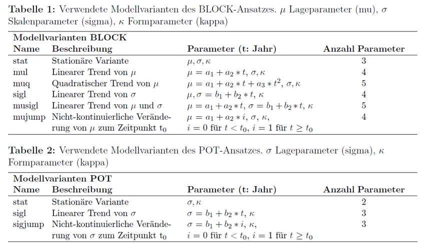
Executive summary
In 2019 JBA Consulting carried out a rapid evidence assessment (REA) on behalf of
the Environment Agency to synthesise current knowledge on stationarity or non-
stationarity in sources of fluvial, coastal and pluvial flooding in the UK. The results of
that study are reported in ‘Rapid Evidence Assessment of Non-Stationarity in Sources
of UK Flooding’, June 2019.
This report describes a follow-on phase of work that investigated how the Environment
Agency, along with equivalent bodies in other UK countries, might deal with the issues
that were identified in the REA. It includes a review of international practice in the USA,
Canada, Australia, Netherlands, Germany and Switzerland, covering official guidance
from flood risk management authorities and approaches used by practitioners. It also
identifies other UK initiatives on non-stationarity at research institutes, UK universities
and in the insurance sector.
Based on these findings the following recommendations for future research and
practice are made:
Take a more holistic approach to non-stationary fluvial flood frequency that
looks beyond annual maximum peak flows to consider aspects such as the
magnitude and frequency of all floods, their tendency to cluster, their duration,
and hydrograph shapes and volumes.
Develop a practical method of non-stationary flood frequency estimation that
can be applied on ungauged catchments and reduces the uncertainty
associated with single-site frequency analysis.
Integrate the modelling of past and future non-stationarity in flood flows. This
will include work to attribute observed trends.
Commission a scoping study that looks at trends in extreme rainfall, options for
incorporating non-stationarity in UK rainfall frequency analysis, and the need to
merge modelling of past trends and future expected climate change.
As part of the sensitivity testing in flood risk mapping, test the impact of
increasing/decreasing the future tidal range by +/- 10% of the mean sea level
rise being applied.
Further analysis of regional tidal models and their response to sea level rise, to
reduce uncertainty around the local sign and magnitude of tidal changes.
Analyse the changes to future tidal curves from existing studies investigating
the impact of sea level rise on astronomical tides.
Improve quantification of the natural variability of storm surges.
Reassess tide gauge records for accelerating sea level rise when next updating
either the Coastal Flood Boundary or State of the Nation data sets.
Test the sensitivity of inshore wave direction to changes in offshore wave
direction.
2 Recommendations for future research and practice on non-stationarity in UK flooding
Maintain the current networks of tide, river and rain gauges.
Acquire high quality, multi-decadal wave observations in suitable locations.
Research methods to correct/blend hindcast and observed data to improve
wave hindcasts.
Run a high-resolution UK scale long wave hindcast based on ERA-5 winds
(1950 to 2020).
Recommendations for future research and practice on non-stationarity in UK flooding 3Acknowledgements We are grateful to all of the following for responding to our requests for information: Rory Nathan, Associate Professor in Hydrology & Water Resources, University of Melbourne, Australia Donald H Burn, Professor Emeritus, Civil & Environmental Engineering, University of Waterloo, Canada Gabriele Villarini, Director, IIHR—Hydroscience & Engineering; Associate Professor, Civil & Environmental Engineering, University of Iowa, USA John Chester, Amod Dhakal and Alexis Dufour, San Francisco Public Utilities Commission, USA Dr Ferdinand Diermanse, Delft Hydraulics/Deltares, Netherlands Prof Steffen Bold, Rottenburg University of Applied Sciences, Germany Dr Michael Stölzle, Freiburg University, Germany Dr Uwe Ehret, Karlsruhe Institute of Technology, Germany Peter Mittag and Frank Wolters, Administrative District Office, Tübingen, Germany Andreas Stegmaier, Regional Authority Tübingen, Germany Sven Berendsen, Newcastle University, previously Aquantec Karlsruhe, Germany Dr Thomas Wöhling, Dresden University of Technology, Germany Bernd Mehlig, State Agency for Nature, Environment and Consumer Protection North Rhine-Westphalia, Germany Dr Manuel Antonetti, Zurich University of Applied Sciences, Switzerland Caroline Kan, Bundesamt für Umwelt (BAFU), Switzerland Dr Louise J. Slater, Associate Professor, University of Oxford; Chair, Oxford Water Network Dr Emma Eastoe, Lancaster University Professor Jonathan Tawn, Lancaster University Dr Thomas Kjeldsen, University of Bath Dr Stephen Blenkinsop, Newcastle University Dr Elizabeth Lewis, Newcastle University Dr Simon Brown, Lead Scientist and Climate Extremes Research Manager, Met Office Dr Mark McCarthy, Manager National Climate Information Centre, Met Office Lisa Stewart, UK Centre for Ecology and Hydrology Dr Kathleen McInnes of CSIRO, Australia. Dr Arne Arns, University of Rostock, Germany Dr Sönke Dangendorf, University of Siegen, Germany Dr Robert Vos, Rijkwaterstaat, Netherlands 4 Recommendations for future research and practice on non-stationarity in UK flooding
Dr Kathleen White, US Army Corps of Engineers, United States
Prof. Thomas Wahl, University of Central Florida, United States
Dr Judith Wolf, National Oceanographic Centre, UK
Enda Murphy, National Research Council Canada, Canada

            Recommendations for future research and practice on non-stationarity in UK flooding   5
Contents
1 Background 7
1.1 Wave conditions 8
2 Purpose of this report 9
3 Approach to investigation 10
4 International practice for handling non-stationarity in flood risk
management 11
4.1 USA 11
4.2 Canada 14
4.3 Australia 16
4.4 Europe - general 17
4.5 Netherlands 18
4.6 Germany 19
4.7 Switzerland 21
4.8 Summary of international practice 23
5 Practice for handling non-stationarity in the insurance sector 24
6 Related initiatives 26
6.1 University research programmes 26
6.2 Met Office 28
6.3 UK Centre for Ecology and Hydrology (UKCEH) 29
6.4 National Oceanography Centre 29
6.5 Marine Climate Change Impacts Partnership 30
6.6 Wave climate projections 31
7 Recommendations for future research and practice 34
7.1 Rivers 34
7.2 Rainfall and run-off 37
7.3 Estuaries 39
7.4 Non-stationarity of astronomical tides 39
7.5 Storm surges 40
7.6 Sea level rise acceleration 40
7.7 Waves 41
7.8 Data 42
7.9 Summary of recommendations 43
References 45
List of abbreviations 50
Appendix A: Summary of coastal flood risk and flood management guidance in
the UK, USA, Australia, Germany, and the Netherlands 52
6 Recommendations for future research and practice on non-stationarity in UK flooding1 Background
In 2019 JBA Consulting carried out a rapid evidence assessment (REA) on behalf of
the Environment Agency to synthesise current knowledge on stationarity or non-
stationarity in sources of fluvial, coastal and pluvial flooding in the UK.
The primary question was:
What is the evidence for stationarity or non-stationarity in sources of UK
flooding?
Three secondary questions were also addressed:
What can cause non-stationarity in the sources of UK flooding?
What techniques are used to detect and account for non-stationarity in the
sources of UK flooding?
To what extent does an assumption of stationarity or non-stationarity alter the
outcome of flood risk analysis?
The assessment extracted evidence from 334 published articles, selected from an
initial list of nearly 10,000 identified by a literature search. A critical appraisal led to a
final set of 144 articles that were judged to be sufficiently relevant and robust.
A final report, ‘Rapid Evidence Assessment of Non-Stationarity in Sources of UK
Flooding’, was submitted in June 2019. The report summarised the findings of the
articles in relation to the presence or absence of non-stationarity, the aspects of flood
hazard that are thought to be non-stationary, the direction of change, the way in which
change was detected and the causes of non-stationarity.
The evidence showed a general, but not universal, consensus that both precipitation
and flood flows on rivers are increasing. These findings of non-stationarity in sources of
inland flooding contrast with the current common practice of not allowing for non-
stationarity when carrying out frequency analysis of rainfall and peak flow data.
On coastal extremes, the evidence agreed with current practice for present day
extremes analysis but disagreed for assessments of future climates. The evidence
indicated a discrepancy with current practice regarding the assumption of stationarity of
the astronomical tide distribution (once the rise in mean sea level is accounted for).
Studies found evidence that the future distributions of all coastal flood sources are non-
stationary under climate change.
Little evidence was found to answer the question on the extent to which an assumption
of stationarity or non-stationarity alters the outcome of flood risk analysis.
A separate project, also commissioned by the Environment Agency and led by JBA,
has developed interim guidance and tools for practitioners to apply non-stationary
frequency analysis of fluvial flooding. The project report, completed in March 2020,
includes several recommendations for further research and development.
Recommendations for future research and practice on non-stationarity in UK flooding 71.1 Wave conditions
There is a special focus on wave conditions in this background section, not given to
any other variables because the wave conditions used in extreme value assessments
do not go directly into flood risk mapping unlike extreme sea levels and fluvial flows.
Near the coast wave conditions are strongly depth dependent and, for this reason, the
nearshore wave climate is highly non-stationary under rising mean sea level.
Statistical assessments used for flood risk studies in England are based on offshore
waves which do not show this same behaviour. All references to waves in this study
refer to the offshore wave conditions used in statistical assessments.
For context, the following explains the link between these offshore wave conditions and
the resulting flood maps used by the Environment Agency for the two methods
currently used. In both methods, extreme sea levels applied to produce the return
period flood maps are based on tide gauge data, dynamically interpolated around the
coast using a hydrodynamic model (Coastal Flood Boundary Dataset).
Much coastal flood modelling carried out over the last 15 years has been based on the
FD2308 joint probability guidance, which follows this methodology:
Calculate extreme sea level and wave height return period events based on
nearshore sea levels and offshore wave heights.
Use wave transformation modelling or a simplified approach to transform
offshore waves to the inshore.
Calculate the wave overtopping based on these inshore waves and water level
conditions.
Produce return period flood maps from a hydrodynamic model using return
period wave overtopping inflows and a return period sea level boundary.
We now have the more advanced State of the Nation methodology which considers
more parameters in the joint probability and assesses the return period based on the
wave overtopping rate as opposed to the likelihood of the offshore conditions. This
method is as follows:
Extreme storm conditions (coincident wave, wind and sea level) conditions are
assessed based on offshore winds and waves and tide gauge sea levels.
Local wave transformation modelling and emulation is carried out to transform
offshore storms (wave, wind, sea level) to inshore wave and water level
conditions.
Wave overtopping is calculated based on these inshore wave and water level
conditions. Wave overtopping is ranked to obtain return period flows.
Return period flood maps are produced from a hydrodynamic model using
return period wave overtopping inflows and a return period sea level boundary.
Therefore, Environment Agency flood maps already account for the non-stationarity
between present day and future nearshore wave conditions and wave overtopping due
to mean sea level rise.
8 Recommendations for future research and practice on non-stationarity in UK flooding2 Purpose of this report
The rapid evidence assessment (REA) process does not necessarily translate
straightforwardly into a plan of action. Its aim is to answer questions rather than
develop recommendations. The REA report did identify some gaps in knowledge and
some potential ways forward, but more targeted work was needed to identify areas for
future research and practice. Another requirement was to set the future direction within
an international context since the REA was focused on non-stationarity in the UK, and
did not specifically focus on literature about methods for non-stationary frequency
estimation, which do not tend to be location-specific.
A particular reason for studying the international context is to address the perception
that some countries are more advanced than the UK in the way that they deal with non-
stationarity in flood risk management. The USA and the Netherlands have been cited
as examples and so this investigation has focused on them, along with a number of
other developed countries.
This note describes a follow-on phase of work that investigates how the Environment
Agency, along with equivalent bodies in other UK countries, might deal with the issues
that were identified in the REA. Its aims are to:
carry out an international review of current practice in allowing for non-
stationarity in rainfall frequency, pluvial, fluvial and coastal flooding, covering
both official guidance from flood risk management authorities and approaches
used by practitioners
identify any other UK initiatives on non-stationarity, for example at the Met
Office or in UK universities and the insurance sector
in light of the findings from the REA and tasks 1 and 2, formulate
recommendations for a programme of future work on non-stationarity in:
rainfall
pluvial flooding
fluvial flooding (looking beyond the interim guidance project mentioned
above)
coastal flooding
The above aims are covered in sections 4 to 7 of this report, following a brief
description of how the information on current practice and related initiatives was
sought.
Recommendations for future research and practice on non-stationarity in UK flooding 93 Approach to investigation This investigation covers a broader scope than the REA, which focused largely on academic literature. It does not claim to be a comprehensive and systematic investigation. Rather, it has been targeted at countries, universities, research institutes and other bodies that are more likely to be applying or developing methods of non- stationary flood frequency estimation and from which information could more easily be obtained. The information search was restricted to material written in English, German or Dutch. Information was sought both from official sources such as policy and guidance documents and unofficial sources such as individual researchers, flood managers and practitioners. A large number of people were consulted, either via email, phone conversations or face to face. The project team is grateful to all who responded. They are listed in the acknowledgements. The focus of the investigation of international practice was on approaches that allow for non-stationarity within the practice of flood risk management, as distinct from research into the topic and detection of trends without allowing for them in frequency analysis. For fluvial/pluvial flooding, the study did not focus on adjusting stationary flood estimates to allow for the potential future impact of climate change as this practice is now long-established, including in the UK. Instead, the focus was on non-stationary analysis, which generally represents gradual changes over time. This is the aspect for which the REA identified a gap between research findings and current UK practice. The REA results supported the methodology currently used for present day extremes assessments for coastal flood risk. With respect to coastal flood risk, the discrepancy between current practice and the REA findings regarded future extremes. Therefore, for coastal aspects this investigation of international practice focused on adjusting present day estimates to allow for potential future impacts of climate change. 10 Recommendations for future research and practice on non-stationarity in UK flooding
4           International practice for
            handling non-stationarity in
            flood risk management
A summary of the coastal flood risk and flood management guidance used to inform
this section is summarised in Appendix A. This summary includes the scientific basis at
the time of writing; if the guidance is statutory and the climatological assumption for
tides, waves and storm surges. For comparison, the summary includes the guidance
for England, Scotland and Wales.

4.1         USA
Water management in the USA can be considered at the federal (national), state and
city (and/or county) level. All levels of government have the authority to issue flood
policy or technical guidance. Individual states and cities/counties are responsible for
local flood policies and management and their guidance may vary from federal
guidance. Information on non-stationarity from those three levels is summarised below.

4.1.1       Fluvial/pluvial
At a federal level, the United States Geological Survey (USGS) published guidance on
flood frequency estimation is Bulletin 17C (England and others, 2019). This document
is used nationally for flood frequency estimation, as per the Flood Estimation Handbook
(FEH) in the UK. Bulletin 17C recognises non-stationarity but does not provide
guidance on how to incorporate it practically within flood estimates:
"The Work Group did not evaluate methods to account for nonrandomness and (or)
multidecadal trends in flood frequency. Additional work in this area is warranted, as it is
a seriously unresolved problem. If multidecadal trends of this sort are identified through
appropriate statistical tests and data analysis, it is recommended that the underlying
physical mechanisms be investigated to gain hydrological understanding. How to adjust
such a record for flood frequency is an unresolved problem".
Indeed, Bulletin 17C suggests addressing non-stationarity in a future study.
Academically, modifying the earlier Bulletin 17B methods to allow for non-stationarity
has been considered, but these do not appear to have been applied operationally
(Griffis and Stedinger, 2010; Luke and others, 2017; Over, 2016).
The US Army Corps of Engineers (USACE) has developed a web tool for identifying
non-stationarity in historical time series (USACE, 2018a) and guidance for using it
(USACE, 2018b), but has not yet provided any guidance on how to allow for non-
stationarity in carrying out hydrological estimates. An author of the guidance has told
the JBA project team that he expects the next step will be to move from detection
towards attribution, and to then incorporate that information in future designs.
Similarly, the US Environmental Protection Agency (USEPA) has carried out research
advocating the need to allow for adaptation (Yang, 2010) and also provides monitoring
of climate indicators (USEPA[a] and USEPA[b], undated). However, no guidance on
how to directly account for non-stationarity appears to be currently available from the
EPA.
There is a similar picture at a state level. For example, the State of California Energy
Commission carried out research on changes to depth duration frequency curves under

             Recommendations for future research and practice on non-stationarity in UK flooding   11
climate change (AghaKouchak and others, 2018) recognising non-stationarity, but it is unclear if this research has been applied operationally. On the east coast, the South Florida Water Management District has also studied non-stationarity (Obeysekera and others, 2011), but it does not appear to be practically applied in water management other than indirectly through adaptation measures. At a local level (for example, city or county level), many water utilities have identified non-stationarity as an issue. For example, a manager at the San Francisco Public Utilities Commission (SFPUC), restated the "Stationarity is dead" quotation when interviewed (Carpe Diem West, 2011). The SFPUC, together with 11 other local water utilities, including New York City Department of Environmental Protection (DEP) and Seattle Public Utilities, is part of the Water Utility Climate Alliance (WUCA) which is seeking to manage climate change at a local level. WUCA provides climate change adaptation case studies (WUCA, undated [a]) ranging from water quality in Seattle to dam safety in Colorado. However, none of the adaptation studies provided directly account for non-stationarity. Similarly, studies on depth duration frequency curves (Storm Water Solutions, 2019) carried out on behalf of the New York DEP describe the issue of non-stationarity and the need for climate resilience (Rosenweig and Solecki, 2015; WUCA, undated [b]) but do not appear to provide practical application of accounting for non-stationarity. Information from Seattle Public Utilities (Fleming, 2012) also paints a similar picture. 4.1.2 Coastal At the national level, there are 4 primary agencies issuing infrastructure or building policy and guidance: the US Army Corps of Engineers, the Department of Defense (DoD), the Federal Emergency Management Agency (FEMA), and the Federal Highway Administration (FHWA). The USACE provides extensive guidance around sea level changes and coastal erosion, as do other US agencies, including the US Geological Survey and National Atmospheric and Oceanic Administration (NOAA). The USACE policy and guidance related to changing sea level is encapsulated in Engineer Regulation 1100-2-8162 (USACE, 2019a) which applies to all USACE elements having civil works responsibilities and applies to all USACE civil works activities. The guidance is that all planning studies and engineering designs over the project life cycle, for both existing and proposed projects, must consider alternatives that are evaluated for ‘low’, ‘intermediate’, and ‘high’ sea level changes, corrected for local rates of vertical land movement. The low, intermediate and high scenarios at NOAA tide gauges can be obtained through the USACE online sea level calculator (USACE, undated). The USACE guidance makes no future allowances for storm surges, tides or waves, basing its approach on a consensus that changes to tropical cyclone frequency and intensity cannot identify any climate change signal from within the natural variability (Knutson and others, 2010). More detailed guidance and worked examples are provided in the USACE Engineer Pamphlet 1100-2-1 (USACE, 2019b). This pamphlet acknowledges the importance of potential non-stationarity in assessing future sea level conditions, making the statement: “USACE SLC adaptation addresses the potential for non-stationary conditions through the use of a multiple scenario approach, which includes a range of future potential sea level change rates.” However, it makes no further comment regarding non-stationarity in tide, wave or storm surge conditions. The Department of Defense (DoD) policies and guidance (DoD, 2018a; 2018b) also make explicit reference to climate change allowances. These two guidance documents are currently being revised to incorporate a spatially varying approach to sea level 12 Recommendations for future research and practice on non-stationarity in UK flooding
change in the same way as UK Climate Projections 20181 (UKCP18). The sea level
scenarios will follow the advice given in Hall and others (2016), which provides a global
scenario database for regionalised sea level and extreme water level scenarios for 3
future time horizons (2035, 2065, and 2100) for 1,774 DoD sites worldwide. The
extreme still water level estimates are provided for different annual chance events
whose probabilities depend on the underlying scenario assumptions. The extreme
water levels include the effects of tides and storm surge, occurring on top of rising seas
as specified in the 5 sea level rise scenarios. However, they do not include the effects
of waves. Neither do they account for potential non-stationarity in future storminess.
There is large diversity in the quality of guidance and approaches taken at the state
and city level (and the scope and duration of this project did not permit a thorough
comparison and analysis of all US locations). New York, New Jersey, Maryland and
California all have well described policy for coastal development, supported by good
technical guidance. Here, we summarise the approach of the more forward-looking
New Jersey state-level response to climate change. New Jersey has made it
compulsory to consider sea level changes through Executive Order 100 (27 January
2020). This states that [authorities must] “within two years of the date of this Order and
consistent with applicable law, adopt Protecting Against Climate Threats (PACT)
regulations”; and that these regulations shall, “integrate climate change considerations,
such as sea level rise, into its regulatory and permitting programs, including but not
limited to, land use permitting, water supply, stormwater and wastewater permitting and
planning, air quality, and solid waste and site remediation permitting.” The State of New
Jersey Department of Environmental Protection tasked a team led by Rutgers
University to produce a guidance document (Kopp and others, 2019) based on the
most current science on sea-level rise projections and changing coastal storms,
considering the implications for the practices and policies of local and regional
stakeholders, and providing practical options for stakeholders to incorporate science
into risk-based decision processes. That report (Kopp and others, 2019) provides
future sea level guidance in a manner very similar to UK Climate Projections 2018
(UKCP18), (and arguably uses more scientific language and detail than UKCP18).
However, the guidance does not consider any changes to the future climatology of
storm surges, stating that there is no clear basis for planning guidance for New Jersey
to deviate from the most recent examinations of the issues by the New York City Panel
on Climate Change (Orton and others, 21019). Nor does it assume any changes to
future tidal characteristics or wave climate.

4.1.3          USA summary
While non-stationarity is recognised as an issue in fluvial/pluvial assessments in the
USA, it is not being directly addressed in the way that flood frequency estimation is
carried out. The problem of future changes to flood risk is being addressed via
adaptation measures such as allowances for climate change. For coastal flood risk
assessments of future conditions, these allowances for climate change account for
rising mean sea level but assume tides, storm surge and waves are stationary. The
Department of Defense policies and guidance is currently being updated and they do
plan for future extreme sea levels to include the effects of tides and storm surge,
occurring on top of rising seas, but will still not account for potential changes in waves
or storminess.

1   https://www.metoffice.gov.uk/research/approach/collaboration/ukcp/index
    [accessed 16 July 2020]. [Accessed 21 July 2020]

                Recommendations for future research and practice on non-stationarity in UK flooding   13
4.2 Canada 4.2.1 General The federal government has recently standardised approaches through its Federal Floodplain Mapping Guidelines Series. The Federal Hydrologic and Hydraulic Procedures for Flood Hazard Delineation 2019 (Natural Resources Canada, 2019) provide technical guidance on hydraulic and hydrological procedures for preparing flood hazard maps in Canada, including incorporating non-stationary processes such as climate change. This guidance recommends careful trend analyses before carrying out extreme value analyses. 4.2.2 Fluvial/pluvial The federal procedures mentioned above state that most projects assume stationarity when assessing fluvial flood frequency. One paragraph provides two references to research that has applied non-stationary techniques, and recommends that the practitioner considers whether the additional complexity is warranted. It concludes, “For example, it may be more cost-effective to account for climate change by applying a reasonable but conservative factor to the results of a stationary FFA.” The ongoing FloodNet research initiative is a concerted effort that aims to enhance flood forecasting and management capacity in Canada. Funded by the Natural Environment and Engineering Research Council of Canada, it is expected to lead to practitioners applying manuals, guidelines, design methods and software tools, including a Canadian equivalent of the UK’s Flood Estimation Handbook. FloodNet has produced numerous papers that mention non-stationary methods, for both rainfall and river flood frequency. One of the outputs from the research programme will be a set of procedures for flood estimation applicable throughout Canada, for the first time. At this stage, the team is not planning for this to include non- stationary flood frequency analysis procedures. It does not consider that the methodologies it has explored are mature enough to be included (which is an interesting comment from Professor Don Burn who has published works on non- stationary flood frequency for many years). Practitioners in Canada are starting to incorporate non-stationary techniques or consider non-stationarity in rainfall frequency analysis. For this reason, the FloodNet team is planning to provide some guidance on non-stationarity for rainfall frequency analysis. 4.2.3 Coastal There is currently no standard approach for including non-stationarity in coastal flood risk assessments in Canada. Land use planning and zoning is typically governed at the provincial or municipal level and, as such, approaches to flood risk assessment have varied widely across the country. Based on our correspondence with the National Research Council Canada who recently reviewed current guidance and practice for the federal government, the most common approach to non-stationarity in Canada is to incorporate regional relative sea-level rise projections to the end of the 21st century, detrend historical water level records, and assume all other variables are stationary. It is rare to see studies including (even notional) changes in winds, waves or storm surges. As an example of current guidance, the province of British Columbia has had guidelines for Flood Hazard Area Land Use in place since about 2010 (draft amendment in 2013, adopted in 2018). These guidelines include a recommended sea 14 Recommendations for future research and practice on non-stationarity in UK flooding
level rise curve (Ministry of Forests, Lands, Natural Resource Operations and Rural
Development, 2018a, section 3.5.3). But overall, they are pretty crude in how they
account for non-stationarity. Consequently, a provincial professional association
(Engineers & Geoscientists British Columbia) developed its own professional practice
guidelines (Ministry of Forests, Lands, Natural Resource Operations and Rural
Development, 2018b). However, these are more informational/educational and not
prescriptive: “Hydro-climatological modelling is an expert activity; the responsibility of
the QP is to be familiar with current model-based projections, including the specified
precision of those projections. Professional judgment must be exercised to extract the
most appropriate design parameters for particular projects from currently available
climatic projections. Results should be compared with the historical record to determine
whether they are plausible for the project site.” Other coastal provinces, such as New
Brunswick, are really only just beginning to look at policies for land use
planning/regulation that consider coastal flood risk, and are only considering mean sea
level rise not changes in storm surge, waves or tides.
The Procedures for Flood Hazard Delineation (Natural Resources Canada, 2019),
provide guidance on sea level rise. In the case of historical sea level rise, the
practitioner can choose to detrend the time series of historical peaks and correct it to
present-day water levels before calculating present-day return values. Future sea level
rise must then be accounted for in projecting future extreme water levels. The impact of
future sea level rise on wave heights must also be examined, but only the influence of
sea level rise on wave run-up and overtopping, not non-stationarity in the offshore
wave climate.
Canada’s Changing Climate Report 2019 (Bush and Lemmen, 2019) states that
relative sea level rise and declining sea ice conditions are the major risk factors for
coastal flood risk, and that less is known about changes in the frequency and intensity
of storm surges and waves. The National Research Council and academic partners are
presently carrying out research focused on downscaling regional climate model data to
provide projections of future changes in storm surges, extreme waves and ice
conditions in some coastal regions of Canada. However, these have large uncertainty
bands and this type of approach is not common practice.
New national guidelines on coastal and flood risk assessment for building and
infrastructure design applications is currently being developed. This focuses heavily on
non-stationarity and the dynamic nature of risk but is not prescriptive and, as such, is
not expected to lead to immediate significant changes in how non-stationarity is
addressed.

             Recommendations for future research and practice on non-stationarity in UK flooding   15
4.3 Australia 4.3.1 Fluvial/pluvial Australian Rainfall and Runoff (ARR)2 is an equivalent publication to the FEH, published by Geoscience Australia, a government agency. Comprehensively updated in 2019, ARR acknowledges the availability of non-stationary methods, and suggests considering them in some cases, but the focus is still very much on assuming stationarity. One of the main authors, expects few, if any, practitioners are likely to be pushed into applying non-stationary flood frequency procedures by the ARR guidance. However, it would be expected that practitioners would investigate any gross changes in catchment land-use when interpreting possible shifts in the behaviour of annual maximum flows. Most practitioners would resolve any such shifts by censoring or making some adjustment to the annual maxima, rather than by fitting a non-stationary probability model. While there is good evidence that flood behaviour in Australia is influenced by inter-annual climate drivers such as the Interdecadal Pacific Oscillation and El Nino, their variability is assumed to be stationary, at least over the historical record. The Australian Commonwealth Scientific and Industrial Research Organisation (CSIRO) and the Bureau of Meteorology (BoM) make reference to non-stationarity in climate for both rainfall and temperature (and resulting derived quantities) in many of their climate statements and research project summaries. They do not, however, appear to provide guidance on how trends might be accounted for. 4.3.2 Coastal In Australia, sea level rise planning guidelines are the responsibility of state governments rather than the federal government; coastal planning and management decisions are made by local governments within the jurisdiction of a state/territory. Accordingly, local governments require clear policy direction from state/territory governments, financial assistance to implement coastal adaptation initiatives, and access to locally specific scientific information about the coastal impacts of climate change. The scope of state government responses to rising sea levels is varied at the local government level in Australia, and, as with the US, the nature and quality of the guidelines (and the degree to which they are statutory) differs among states. The most up to date scientific advice is provided for each local government area in the 'Sea Level Rise and you' section of the CoastAdapt dataset3. This climate services portal was developed by the National Climate Change and Adaptation Research Facility (NCCARF). For each future climate scenario (RCP) this tool gives (a) the mean sea level rise along with uncertainties and (b) the 'allowances' needed to maintain the same standard of protection as today. For any date epoch, allowances do not necessarily equate to the median projected sea level rise due to the shape of the return period extreme sea level curve. In this data set, stationarity is assumed for tides, storm surges and waves. While individual states could, and arguably should, use the advice given in CoastAdapt, they are not obliged to do so by law. State legislation also only requires non-stationarity of future mean sea level to be considered. 2http://arr.ga.gov.au/ [accessed 15 July 2020] [Accessed 21 July 2020] 3https://coastadapt.com.au/sea-level-rise-information-all-australian-coastal-councils [accessed 15 July 2020] [Accessed 21 July 2020] 16 Recommendations for future research and practice on non-stationarity in UK flooding
4.4         Europe - general

4.4.1       Fluvial/pluvial
Madsen and others (2013) provide a review of applied methods in Europe for flood-
frequency analysis in a changing environment. Quotations include:
"Concerning the potential effects of environmental change on the frequency and
magnitude of design floods, Norway, the UK, two river basin authorities in Belgium, and
two federal states in Germany were identified as having developed guidelines for
directly adjusting design flood estimates derived from models assuming stationarity".
This is referring to adjustments to allow for future changes in climate or land use.
"For most countries flood frequency estimation is currently being undertaken using
models based on a fundamental assumption of a stationary historical record, be it flood
flows or rainfall".
"The move beyond a sensitivity-type approach and towards a new non-stationary
framework based on the use of non-stationary frequency models has been identified as
an important aspiration within the European hydrological science community".
Luke and others (2017) refer to this review, stating that two non-stationary methods of
flood frequency analysis are described: (1) the use of precipitation projections from
future climate scenarios in rainfall-run-off models and (2) the use of a safety margin to
adjust the design flood estimates derived from stationary extreme value analysis.
Neither of these approaches is truly non-stationary.
The findings from Madsen and others (2013), indicating that non-stationary methods
are not generally applied in practice in Europe, have been borne out by information
received from practitioners and others in the Netherlands, Germany and Switzerland as
reported below.

             Recommendations for future research and practice on non-stationarity in UK flooding   17
4.5 Netherlands In the Netherlands, the general governmental policy for sea level rise, lake-level allowances and peak river flows is written down in the ‘National Water Plan’. The latest version is for the period 2016 to 2021 (available in Dutch). The guidelines are quite general and apply to national programmes that deal with flood protection by levees, storm surge barriers, sluices, and dunes. 4.5.1 Fluvial/pluvial Deltares has informed the project team that non-stationary methods of flood frequency estimation are not currently included within formalised procedures in the Netherlands. Rijkswaterstaat, part of the Ministry of Infrastructure and Water Management, was not able to provide any information on the application of non-stationary methods in the Netherlands. The project team has found no references to operational use of non- stationary flood frequency estimation in the Netherlands. 4.5.2 Coastal The largest national programme for flood protection is Hoog Water Beschermings Programma (HWBP). The design of levees, storm surge barriers and sluices in this programme takes account of future sea level rise, but assumes wind, tides and storm surges are stationary. Changes to nearshore wave properties (due to increases in mean sea level) result from the wave models used SWAN (simulating waves near shore) despite no prescribed changes to the wind forcing. This project fits with our understanding of the general Dutch approach, which is: assume the same wind scenarios for 2100 as present, and force local wave models with adjusted sea levels but the same winds to account for changes to depth limiting. Understanding flood risk management concepts from Rijkswaterstaat has been reviewed to understand the general guidance on how coastal flood risk drivers are changing. For the assessment of present day risk, the report states that mean sea level rise (MSLR) off the Dutch coast has been approximately 0.20 m but sea level acceleration is not visible in the North Sea (possibly due to the large variations from year to year associated with variations in wind). Therefore, it is assumed that when assessing present day extremes, sea levels data is detrended to remove a linear trend in sea level rise (SLR). Note, in the Netherlands, land subsidence is also a major issue and therefore the analysis of recorded sea levels also has to take account of this. For the assessment of future extremes, the report states that although wind speeds will probably get higher, it probably won’t apply to winds from the northwest. Storm surges along the Dutch coast are mainly caused by winds from the northwest and therefore no significant change in storm surge this century is expected. Therefore, we deduce that future assessments of coastal flood risk assume the surge risk in the future is the same as today. The report does not consider tides in its section on developments with effect on the water safety. Deltares has applied non-stationary methods to wave statistics, but that was a research project. 18 Recommendations for future research and practice on non-stationarity in UK flooding
4.6         Germany
In Germany, the different states are responsible for flood protection, which means that
there are different approaches to flood risk in each federal state.

4.6.1       Fluvial/pluvial
Information from academic staff at Rottenburg University of Applied Sciences and
Freiburg University indicates that, while non-stationarity is becoming increasingly
important in research, most engineering consultancies and their clients do not consider
it, although this may start to change.
Implementing non-stationary methods in practice within Germany (and anywhere else)
is complicated by the fact that all models/processes have to estimate the influence of
climate change on historical data, and it is difficult to be confident in these estimates. It
is also felt that the priority is to improve stationary methods first, for example
reconsidering the choice of distribution for the regionalisation of rainfall frequency, for
which the German Meteorological Service currently assumes the Gumbel distribution.
Non-stationarity is thought to be particularly important with regards to snowmelt in
alpine regions and intense rainfall.

Baden-Württemberg, Bavaria and Rhineland-Palatinate
Information from several members of staff at regional authorities and consultants
indicated that non-stationary methods of flood frequency estimation are not applied. In
some cases, trends are extrapolated, and assumed to be linear. When designing flood
defences, climate change factors are added.

Saxony
Practitioners apply methods based on assuming stationarity. Non-stationarity is a topic
of interest in research, for instance at the Dresden University of Technology.

North Rhine-Westphalia
The State Agency for Nature, Environment and Consumer Protection, North Rhine-
Westphalia, provided a useful perspective, saying:
“Non-stationary statistics are not being applied in water management as there are still
no methods that have proven to be practicable, let alone decisive, with regard to
application in practice. R&D projects currently show that climate change-related trends
in precipitation time series are not clear, and that changes in measurement technology
or meteorological cyclical changes can also cause change points, which may overlay
the trend caused by climate change. So far, non-stationary statistics have not provided
any clear or generally accepted solutions that are relevant in practice. Currently the
workaround is to calculate additional scenarios, to check the sensitivity of the system
and to include the result in the design of the system.”

4.6.2       Coastal
In Germany, the federal government adopted the German Strategy for Adaptation to
Climate Change in 2008 (DAS), which provides a framework for all climate adaptation
actions in Germany. The DAS is supported by a second policy document called the

             Recommendations for future research and practice on non-stationarity in UK flooding   19
Adaptation Action Plan (APA), which was adopted by the federal government in 2011 (updated in 2015) and constitutes the central reference element of the German climate adaptation policy. In simple terms, the APA specifies the options and possible activities to implement the actions suggested in the DAS. Regarding coastal protection specifically, beyond any differences in approaches across German states, stationarity is generally assumed for all sources of coastal flooding except mean sea level for which a constant rate of sea-level rise (no acceleration in sea level) is considered. The mean sea level rate used differs between regions. Hazard mitigation plans incorporate safety margins, which discount uncertainty in current estimates of future sea-level rise as well as, at least partly, non-stationarity in other sources of flooding such as storm surges, waves and tides. 20 Recommendations for future research and practice on non-stationarity in UK flooding
4.7 Switzerland
4.7.1 Fluvial/pluvial
The Federal Office for the Environment (BAFU) published a guide for flood assessment
in 2003 in which statistical methods are described that are commonly used in practice.
All of these methods are based on the assumption of stationarity.
However, the BAFU also publishes reports on flood statistics4 for all gauges in
Switzerland with a catchment area larger than 100 km2 that summarise results of
calculations based on a variety of methods, some of which are non-stationary. A guide
to the reports is also provided, released in 2017 (BAFU, 2017). The reports are used to
identify non-stationarity in data, and to assess the differences between the results from
different methods.
The methods applied are:
annual maximum flow analysis
o stationary
o non-stationary: linear time trend in location parameter
o non-stationary: quadratic time trend in location parameter
o non-stationary: linear time trend in scale parameter
o non-stationary: linear time trends in location and scale parameters
o discontinuous variant of a linear model, with a change point in the
location parameter, to represent abrupt structural changes such as
construction of a dam
peaks over threshold (POT) flow analysis
o stationary
o non-stationary: linear time trend in location parameter for flood
magnitude
o discontinuous variant of a linear model, with a change point in the
location parameter
(note that non-stationarity in the flood occurrence rate is not considered)
The (untranslated) table below from the guidance shows the formulae for the
parameters in each model variant, with t representing the year.
4 An example report:
https://www.hydrodaten.admin.ch/lhg/sdi/hq_studien/hq_statistics/2602_hq_Bericht.pdf
[accessed 15 July 2020]. [Accessed 21 July 2020]
Recommendations for future research and practice on non-stationarity in UK flooding 21Table 4-1 Example of non-stationary parameters in BAFU (2017)
It is up to the reader to decide which set of results will be selected, and a flow chart is
provided to help with this decision. The main factors to consider when deciding which
model to select are:
a statistical comparison of the model fit using likelihood ratios, where this is
possible
hydrological plausibility
checks of model fit using diagnostic plots
The guidance makes it clear that even when methods are taking non-stationarity into
account, they only approximate reality. Furthermore, it remains unclear whether a trend
will continue in the future. Nevertheless, the site history may help draw conclusions
about the causes of a change. If these are known, future developments may be
estimated.
This is the only example outside the UK that the project team has found where non-
stationary methods are applied in practice.
22 Recommendations for future research and practice on non-stationarity in UK flooding4.8 Summary of international practice
4.8.1 Present day extremes
Apart from sea level rise, non-stationary methods of flood frequency estimation are not
mandated by flood management authorities or generally used by practitioners in the
USA, Canada, Australia, the Netherlands or Germany. The only example that the
project team found of them being used by practitioners is in Switzerland, where the
Federal Office for the Environment has fitted a range of non-stationary models to peak
flow data from many catchments and provided brief guidance on model selection.
4.8.2 Future extremes
Sea level change accelerations are implicit in the UK allowances for future epochs
since the recommendations derive from the dynamical models. At the time of writing,
the UK is unique among the countries examined in both using the most up to date
scientific advice (from UKCP18 and the CMIP5 climate models of IPCC AR5) and for
making it compulsory to use that advice. Comparing the UK with other national
approaches, only specific city authorities and states in the US, and a minority of states
in Australia adopt the same rigorous approach.
In all the international reviews carried out as part of this report, all countries assume
that the future climatology of storm surges, tides and waves is unchanged (that is, they
assume stationarity). However, the potential for changes, particularly in waves, is
recognised and accommodated through the recommendation of sensitivity tests for
flood risk.
Recommendations for future research and practice on non-stationarity in UK flooding 235 Practice for handling non-
stationarity in the insurance
sector
Flood modelling within the insurance industry is carried out by catastrophe (cat)
modelling vendors whose modelling practice in relation to non-stationarity is considered
here. Firstly, a quick summary of the core components of a cat model is provided for
context.
Flood-based cat models are made up of 3 components: the hazard (hydrometeorology
and the sea – ‘hydrology’), the hazard mapping, and the vulnerability (resulting in
financial loss estimates). For present-day rainfall and fluvial scenarios, statistical
methods and hydrological models are applied assuming stationary data. Due to the
clear rise in mean sea levels, the present-day sea level extremes are estimated after
removing a linear trend.
The results of these rainfall, flow, and sea level and wave models are applied to
mapping models (usually hydrodynamic) to provide the mapped extents of coastal,
river and pluvial flooding and associated depths. The mapping boundary conditions are
either point estimates, usually based on some form of regional frequency analysis (in
the case of fluvial mapping), or directly from simulating correlated events. In the former
case, simulated events are then attributed associated return period depths in the a
priori flood maps. The catastrophe model assesses the severity of the physical risk
(flood) at each location, using the extent and depth information from the hazard map
and stochastic event set data. Vulnerability functions denote the depth-damage
relationship for different property types, which helps determine the potential financial
loss at a given location. Cat modelling vendors can sell products holistically or
individually, as the mapping, the loss estimation or the simulated event sets. This is an
important distinction because baseline flood maps, which are similar to those produced
by the Environment Agency, can be updated to account for scenario projections in
relatively simple ways, whereas updating the simulation of nationally (and
internationally) spatially and temporally correlated events across flood perils is non-
trivial.
The risk management and banking sectors increasingly need to take climate change
into account, as regulatory authorities question organisations about their resilience
measures and introduce requirements for them to meet. The Prudential Regulatory
Authority (PRA) for example, recently requested that the potential impact of different
projections on average annual loss (AAL) and the 100-year loss be considered for all
relevant insurance contracts.
Given the 3 main components of the cat models, there are 3, or combinations of 3,
ways in which a cat modelling vendor could account for projected changes in the
rainfall and coastal levels (the hazard):
1. directly to the hazard
2. adjustment of the mapping
3. adjustment of the losses
All approaches require assumptions, but the assumptions become broader and less
justifiable moving towards number three when the step before is not considered.
Ideally, the projected changes would be applied to the hazard, and the associated
24 Recommendations for future research and practice on non-stationarity in UK floodingYou can also read