MSFD In-Depth Knowledge of the Marine Environment as the Stepping Stone to Perform Marine Spatial Planning in Greece - MDPI
←
→
Page content transcription
If your browser does not render page correctly, please read the page content below
water
Review
MSFD In-Depth Knowledge of the Marine Environment as the
Stepping Stone to Perform Marine Spatial Planning in Greece
Theodora Paramana 1, *, Aikaterini Karditsa 2 , Niki Milatou 3 , Stelios Petrakis 2 , Persefoni Megalofonou 3 ,
Serafim Poulos 2 and Manos Dassenakis 1

                                          1   Laboratory of Environmental Chemistry, Faculty of Chemistry, National and Kapodistrian University of
                                              Athens, 15784 Athens, Greece; edasenak@chem.uoa.gr
                                          2   Laboratory of Physical Geography, Faculty of Geology & Geoenvironment, National and Kapodistrian
                                              University of Athens, 15784 Athens, Greece; kkarditsa@geol.uoa.gr (A.K.); spetrakis@geol.uoa.gr (S.P.);
                                              poulos@geol.uoa.gr (S.P.)
                                          3   Section of Zoology-Marine Biology, Faculty of Biology, National and Kapodistrian University of Athens,
                                              15784 Athens, Greece; nmilatou@biol.uoa.gr (N.M.); pmegalo@biol.uoa.gr (P.M.)
                                          *   Correspondence: tparaman@geol.uoa.gr; Tel.: +30-210-7274724

                                          Abstract: The multiple anthropogenic activities taking place in the marine environment increase and
                                          create a high demand for maritime space. The pressures generated thereof on coastal and marine
                                          resources require an integrated planning and management approach. The MSPD (2014/89/EU) forms
                                          the legislative framework to regulate maritime activities and ensure a sustainable use of the marine
                                          environment. Based on the MSFD (2008/56/EC), the present study provides an overview of the
                                state of the marine environment in Greece and the existing pressures while examining the potential

                                          contribution of MSFD knowledge to the MSPD implementation, identifying possible knowledge gaps
Citation: Paramana, T.; Karditsa, A.;
                                          for the subsequent MSP process phases. It is supported that the MSFD constitutes the best available
Milatou, N.; Petrakis, S.;
                                          scientific knowledge about the ecosystem and its dynamics, and provides an open access database
Megalofonou, P.; Poulos, S.;
                                          which should be optimally used in the MSP process. The MSFD data provided concerning Greece
Dassenakis, M. MSFD In-Depth
                                          can support the implementation of the MSP process, as the MSFD qualitative descriptors of state and
Knowledge of the Marine
Environment as the Stepping Stone to
                                          pressures feed MSP sectors with environmental data essential for the MSP application, and weigh the
Perform Marine Spatial Planning in        intensity of each descriptor contribution to this interrelationship. Considering MSPD requires the adoption
Greece. Water 2021, 13, 2084.             of an ecosystem-based approach, it can only attain its goals based on MSFD input and aspirations.
https://doi.org/10.3390/w13152084
                                          Keywords: Marine Strategy; policy; environmental legislation; GES; descriptors; MSP sectors; ICZM
Academic Editor: Letizia Lusito

Received: 30 June 2021
Accepted: 27 July 2021                    1. Introduction
Published: 30 July 2021
                                               The various anthropogenic activities such as maritime shipping, fishing, aquaculture,
                                          tourism, renewable energy production, oil and gas exploration and exploitation, extraction
Publisher’s Note: MDPI stays neutral
                                          of raw materials, ecosystem and biodiversity conservation, and underwater cultural her-
with regard to jurisdictional claims in
                                          itage create a high and rapidly increasing demand for maritime space [1]. The unplanned
published maps and institutional affil-
                                          use of the marine space taking place in the course of the last decades, in addition to the
iations.
                                          increasing competition among the human activities at sea, has caused irreversible damages
                                          to the marine ecosystem [2]. Thus, the multiple pressures on coastal resources require an
                                          integrated planning and management approach.
                                               The Maritime Spatial Planning Directive (MSPD) 2014/89/EU is the legislative tool
Copyright: © 2021 by the authors.
                                          used to address these issues, aimed at the sustainable growth of maritime and coastal
Licensee MDPI, Basel, Switzerland.
                                          economies and the sustainable use of marine and coastal resources. It provides an opera-
This article is an open access article
                                          tional framework for MSs to analyse and organize human activities in their marine areas
distributed under the terms and
                                          in order to maintain the value of marine biodiversity and allow the sustainable use of the
conditions of the Creative Commons
                                          economic potential of their seas [3].
Attribution (CC BY) license (https://
creativecommons.org/licenses/by/
                                               Action on MSP at the EU level must be developed in full coordination with existing and
4.0/).
                                          potential policies and initiatives within the field of maritime policy, including in particular

Water 2021, 13, 2084. https://doi.org/10.3390/w13152084                                                         https://www.mdpi.com/journal/water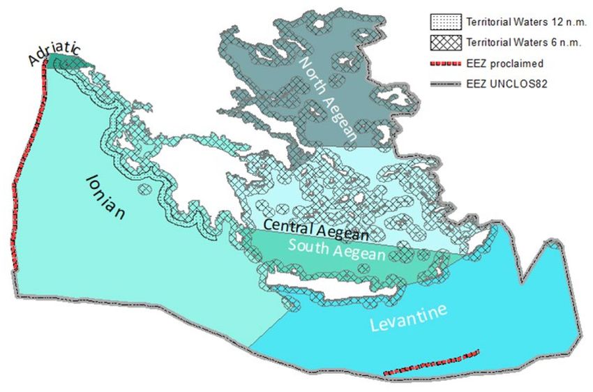
Water 2021, 13, 2084                                                                                             2 of 25

                       the implementation of the Marine Strategy Framework Directive or MSFD (2008/56/EC)
                       and ICZM [4]. The MSFD constitutes an overarching framework directive that sets out
                       environmental objectives to be applied across all European marine regions, integrating all
                       activities that affect marine ecosystems and ensuring sustainable use, although not actually
                       regulating them [5]. Therefore, the directive, strictly following the ecosystem approach,
                       is supposed to comprehensively integrate existing relevant sectorial policies [6] and as a
                       result, alignment and coordination with other sectoral policies is essential to attain the
                       directive objectives both at national and EU levels.
                             The MSPD as a legislative instrument should indirectly apply the ecosystem-based
                       approach as referred to in Article 1(3) of the MSFD (2008/56/EC) with the aim to ensure
                       that the collective pressure of all activities is kept within levels that are compatible with the
                       achievement of GES [2]. The final objective is using the ecosystem approach for evaluating
                       the cumulative impacts and informing and developing marine spatial planning that is able
                       to guarantee the availability and durable use of goods and services [7], as assessing the
                       status of marine ecosystems under an ecosystem approach is fundamental to informing
                       management decisions [8].
                             MSPD and MSFD represent different perspectives on the marine environment.
                       Jones et al. [9] compared the ‘soft sustainability’ of the MSPD, in which the needs of
                       different maritime sectors are balanced, with the ‘hard’ sustainability of the MSFD, in
                       which ecosystem conservation is the core of the ecosystem-based approach. Although
                       both directives have specific objectives, Boyes and Elliott (2014) [10] have highlighted
                       the importance of linking their efforts. In addition, Maza et al. (2020) [11] stressed the
                       need to streamline the widely scattered marine policy landscape and consider all relevant
                       European policies while implementing their obligations. At the end of the day, by resolving
                       conflicts and regulating maritime activities that are drivers of state changes, MSP can make
                       a significant contribution to achieving GES [12].
                             The first round of MSP reporting in accordance with the requirements of MSPD was
                       due in March 2021 but only six countries managed to respond to the requirements [13].
                       To progress with the MSPD implementation, the MSFD can be a powerful instrument for
                       integrated marine management in the European seas whose integration with the ongoing
                       MSP processes can provide concrete data from the assessment and monitoring of the
                       marine environment; can ensure a robust consideration of the marine environment in the
                       planning process; and can promote the application of ecosystem-based management [14].
                       As MSP is based on the best available scientific knowledge about the ecosystem and its
                       dynamics, and there is a need to clarify how national processes concerning the marine
                       environment and ecosystem-based management can support the implementation of EBA
                       in MSP, planners should make optimal use of information gathered and/or reported in
                       relevant policies, especially those referred to the MSFD [15].
                             The responsibility for MSP lies at the national level and addresses maritime activities
                       in a MS’s Exclusive Economic Zone. A transnational, subregional, and even a regional
                       sea perspective is utilized when maritime activities and/or their effects cross national
                       borders [16]. Both MSP and MSFD require a regional cooperation and coordination of
                       activities between member states (MS), and, whenever possible, third countries sharing
                       the same marine region or subregion. For example, to improve adequacy and coherence in
                       MSFD implementation, MSs need to act in a coordinated manner by exchanging experiences
                       and best practices, and aligning approaches, establishing common thresholds and baselines
                       regionally/subregionally [17]. Such cooperation activities are strictly linked to the several
                       priorities that each MS adopts in its marine waters, sharing the management of threats and
                       risks of the region or subregion [18].
                             As Dassenakis et al. (2019) [19] mentioned, a major challenge in applying the
                       ecosystem-based MSP is the gathering of knowledge on the structures and functions
                       of ecosystems, as well as on the pressures and impacts induced on these ecosystems from
                       various human activities. Given the necessity for undertaking an MSP process, the present
                       analysis focused on the characteristics of the Greek marine environment and the pressures
Water 2021, 13, 2084                                                                                           3 of 25

                       induced by anthropogenic activities, with main objectives to: (i) provide an overview of the
                       state of the marine environment in Greece; (ii) examine/indicate the potential contribution of
                       MSFD knowledge to the MSPD implementation; and (iii) state concerns, critical issues, and
                       knowledge gaps in order to frame the subsequent phases in implementing the MSP process.
                             This study has been based on existing information gathered during the implementa-
                       tion of the Marine Strategy Framework Directive [20]. With a view to acquire a comprehen-
                       sive snapshot of the state of the marine and coastal environment and existing pressures, we
                       focused on the implementation of the second cycle of the MSFD in Greece initiated in 2018,
                       which is considerably updated related to the initial assessment conducted in Greece in 2012,
                       as it is based on recent monitoring data. More precisely, the overview was based on the
                       implementation of Articles 8, 9, and 10 as reported to the European Commission by Greece
                       in 2018 according to the requirements of the 2008/56/EC Directive, found in the associated
                       Eionet Central Data Repository hosted by the European Environmental Agency [21]. In
                       some cases, information was enriched with additional published data.

                       2. Area under Investigation
                            In Greece, about 85% of the population is concentrated along the coastline in a zone
                       extending up to 50 km inland, whereas over 75% of the industry, 90% of the tourism, a large
                       part of agriculture, and almost the whole of fisheries and fish farming takes place in this
                       zone [22]. Although Greece has especially significant marine economic activities, experience
                       in implementing MSP is rather limited. Spatial frameworks covering the productive sectors
                       of aquaculture and renewable energy sources and industry have been established, whereas
                       the existing marine parks in Zakynthos and Sporades for the protection of marine turtle
                       and monk seal, respectively, could be considered as early maritime spatial plans adopted
                       in the 1990’s [23].
                            Situated in the eastern Mediterranean Basin, including the Ionian Sea, Aegean (or the
                       Archipelagos), and Levantine Sea, Greece is known for its highly insular and coastal nature.
                       In fact, Greece has mainly insular border limits (Diapontia islands to the west, Castelorizo
                       island to the east, and Gavdos island to the south) neighbouring several coastal countries:
                       Turkey, Cyprus, Egypt, Libya, Malta, Italy, and Albania.
                            The jurisdictions of Greece over its surrounding seas are the following:
                       •    Territorial waters: The Territorial Waters of Greece were very recently (January 2021)
                            set to 12 nm in the Ionian Sea, whereas they are set to 6nm from the baseline in the
                            Aegean and Levantine Sea.
                       •    Contiguous Zone: Greece has no designated contiguous zone.
                       •    Continental Shelf: The continental shelf was only designated in the common maritime
                            borders with Italy in the Ionian Sea with an agreement in 1978 (Greek Law 786).
                       •    Exclusive Economic Zone (EEZ): Greece proclaimed an EEZ towards the west in 2020
                            in agreement with Italy (Law 4716/2020, O.J. 163/A/28-8-2020) and towards the south
                            with Egypt (Law 4717/2020, O.J. 164/A/28-8-2020) (Figure 1).
                             The total surface of Greece is 132,000 km2 , having a coastline of more than 20,000 km.
                       Greece is a highly insular country with 7500 km of its coastline belonging to more than
                       6000 islands and islets, 117 of which are inhabited. The underwater morphology of Greece
                       is diverse with the greatest depth reaching 5127 km (Oinouses Well) in the offshore area
                       southwest of Peloponnese. The continental shelf (defined by slopes < 2%) represents
                       about 4% of the subaqueous relief in the Ionian Sea and 21% in the Aegean Sea [24]. The
                       circulation in the Aegean Sea is generally cyclonic with warm, saline water entering from
                       the Levantine Sea through the eastern Cretan Straits and continuing northwards to the
                       Eastern Aegean Sea in which it subducts below the lighter water coming from the Black
                       Sea. The Black Sea water mass moves along the east coast of Greece towards the south [25].
                       The unconsolidated offshore surficial sediments of the Aegean seabed are mixtures of mud
                       (silt and clay) and sand, while only in some areas silty or clayey-sized sediment replaces
                       the mud content, deposited under the influence of rivers in shelf areas, as well as in most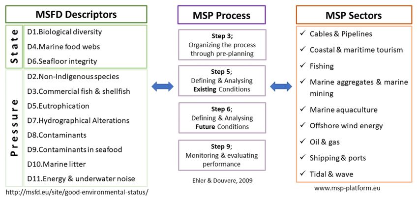
Water 2021, 13, 2084 4 of 25
of the deep basins of the Aegean Sea. The mud component found on the shelves is of a
terrigenous origin [26].
The Mediterranean subregions, as in 2008/56/EC, in which Greece has territorial waters
include: (i) the Aegean–Levantine Sea (≤6 nautical miles), (ii) the Ionian Sea and the Central
Mediterranean Sea (≤12 nautical miles), and (iii) the Adriatic Sea (≤6 nautical miles).
In the aforementioned marine regions, in the first MSFD implementation cycle (2012),
the demarcation of assessment areas was performed based on hydrological, geomorpho-
logical, and biological criteria. The Aegean Sea and Levantine Sea, which are considered a
unified region, were divided into the North, Central, South Aegean, and Levantine Sea for
some descriptors. The south-eastern part of the Adriatic Sea, in which Greece has territorial
waters, were of the same characteristics with the Greek part of the Ionian Sea. In the second
MSFD implementation cycle (2018), these areas are mentioned as marine reporting units
(MRUs) used within the reporting obligations to link the implementation of the different
articles to specific marine areas. Thus, MRUs in Greece include: the Ionian–Adriatic, North
Aegean, Central Aegean, South Aegean, and Levantine Sea (Figure 1).
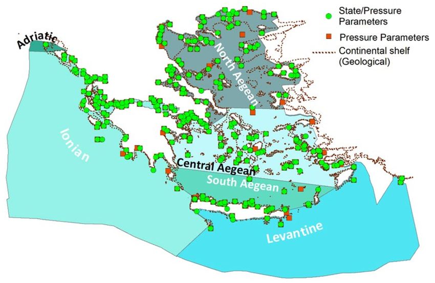
Figure 1. The territorial waters of Greece and marine reporting units as in MSFD.
3. The state of the Marine Environment in Greece
The information in the analysis that follows is presented in accordance with MSFD
Articles 8a (state of the marine environment) and 8b (pressures affecting the marine en-
vironment). In order to depict the state of the environment, the state descriptors of the
MSFD are used, i.e., Descriptors 1, 4, and 6 (D6C4 and D6C5), whereas the presentation
of the pressures component is based on pressure descriptors, i.e., Descriptors 2, 3, 5, 6
(D6C1–D6C3), 7, 8, 9, 10, and 11.
3.1. The State of the Marine Environment in Greece
3.1.1. Biological Diversity; Descriptor 1
The Greek biodiversity is considered to be one of the richest both in the European
and Mediterranean seas and is characterised by a high degree of endemism despite the
prevailing oligotrophic conditions [27]. According to the National Biodiversity Strategy
and Action Plan [27], the monitoring and assessment of the conservation status aims to
halt the loss of biodiversity and the degradation of ecosystem services in Greece by 2026
and restore them as far as feasible.
Water 2021, 13, 2084                                                                                             5 of 25

                             Until now, 3500 animal species have been reported in the marine environment. The
                       species found in coastal and marine ecosystems [27] include: (a) macrophytes: more
                       than 503 taxa of marine algae, including 313 taxa of red algae (Rhodophyta), 103 taxa of
                       brown algae (Phaeophyceae), and 87 taxa of green algae (Chlorophyta), as well as 7 taxa
                       of angiosperms in the sea and brackish water (e.g., Posidonia oceanica, Cymodocea nodosa,
                       Zostera noltei, and Halophila stipulacea); (b) marine mammals: 12 taxa of cetaceans and the
                       Mediterranean monk seal Monachus monachus); (c) marine reptiles: 3 taxa of sea turtles
                       including the Caretta caretta that is reproduced on the Greek shores; (d) fish: approximately
                       480 marine fish species; and (e) zoobenthos: more than 2650 taxa of benthic macrofauna,
                       not including the fauna on the hard substrate of the coast and bathyal zone. Among the
                       37 species of seabirds recorded in Greek waters, there are six that are considered purely
                       seabird species in the Greek context [28].
                             According to Commission Decision 2017/848/EU [29], there are six criteria for Descrip-
                       tor 1: D1C1/species mortality rate; D1C2/species population abundance; D1C3/species
                       population demographic characteristics; D1C4/species distributional range and pattern;
                       D1C5/habitat extent and condition; and D1C6/pelagic habitats’ condition and functions.
                       However, only D1C2 and D1C4 can be addressed appropriately as there is not enough data
                       to address all the criteria.
                             For species population abundance (D1C2), cetaceans, marine reptiles and marine
                       mammals have been considered. With regard to cetaceans, there are no long-term monitor-
                       ing data of all species and, moreover, the lack of data for some cetacean species provide
                       rather uncertain estimates. During the recent years, scientific data on cetacean distribution
                       and ecology are collected by different research groups more systematically [30–35]. The
                       cetacean species occur mostly along the Hellenic Trench (from the western Ionian islands
                       and the Peloponnese to the south of Crete and southeast of Rhodes Island), in Myrtoon
                       Sea, and in areas in the Aegean with steep slopes and great depths. However, some species
                       of Delphinidae such as Delphinus delphis, Stenella coeruleoalba, and Tursiops truncatus occur
                       in coastal areas, straits, and gulfs of Greece. Cetaceans such as Delphinus delphis, Grampus
                       griseus, Stenella coeruleoalba, Tursiops truncatus, Phocoena phocoena, and Physeter macrocephalus
                       are highly threatened by fishing activities (e.g., mainly pelagic surface fishing gear and
                       illegal fishing with dynamite), marine pollution (e.g., plastic bag-swallowing and noise pol-
                       lution), and other maritime activities (collisions with ships, disturbance by navy exercises,
                       and geological research) [30,31,33].
                             As for marine reptiles, Greece hosts 61% of loggerhead turtle nests (Caretta caretta)
                       in the Mediterranean (2015), nesting mainly in the Laganas Bay (Zakynthos Island) and
                       Kyparissiakos Gulf (W. Peloponnese). Green turtles (Chelonia mydas) do not nest in Greece
                       but are regularly detected at sea, albeit at a much lower density than loggerhead turtles.
                       The Lakonikos Gulf is a foraging area for juvenile individuals of Chelonia mydas. Finally, the
                       leatherback sea turtle (Dermochelys coriacea) has a worldwide distribution and its presence
                       in the Mediterranean is 60–200 times lower than in the Atlantic. Degradation of nesting
                       sites mainly due to touristic activities commonly occurs, as well as the predation of eggs
                       and young turtles by foxes, gulls, and other predators. Most importantly, plastic materials
                       consumption, incidental capture to fishing gears, deliberate killing, and collisions with
                       boats constitute major threats for marine reptiles [34–37].
                             Monachus monachus is an endangered species whose habitat deterioration and loss are
                       attributed to human intervention to coasts, deliberate killing, and accidental catching in
                       fishing gears, as well as attributed to marine pollution and diseases. Monachus monachus is
                       mainly distributed in the coastal and insular of Greece but its important populations are
                       located on the Northern Sporades, Kimolos, Gyaros, and Karpathos islands (Mom, 2005).
                       According to Dendrinos et al. (2009) [38], the Ionian islands of Zakynthos and Kefalonia
                       host lower populations. The Greek monk seal population has been estimated at 250 seals,
                       which is equal to 40–51% of the species’ global population [39,40]. For the protection of the
                       species, the Marine Park of Northern Sporades has been established.
Water 2021, 13, 2084 6 of 25
The marine protection areas in Greece for the five most important species of seabirds
extend to 9943 km2 and approximately represent 8.7% of the Greek territory [28].
For Monachus Monachus, cetaceans, marine reptiles, and seabirds, protection areas
have been extended for better protection of the species (D1C2) so that GES will be achieved
in the second MSFD implementation cycle.
To assess benthic ecosystems (D1C4), it was considered that benthic organisms react
to various forms of anthropogenic pressure including organic pollution, disturbance of
sediments by discharges, excavations, and son. Under pressure, resistant benthic organisms
increase in number or density, while sensitive organisms recede. Thus, moderate to high
dominance of opportunistic or resilient species indicates some degree of environmental
pressure. Due to this inherent stability of the benthic ecosystem, zoobenthic and phytoben-
thic bio-communities are used to assess the state of the marine environment. The Bentix
Index combined diversity indices [41] is used for Greek coastal ecosystems and the results
also address D6C3.
Macroalgae are used as biomarkers of the ecological quality of coastal waters due to
their wide distribution, important ecological role, and high sensitivity to anthropogenic
stress. Chronic anthropogenic disturbance such as pollution and eutrophication degrades
the ecosystem and opportunistic species rapidly reproduce and dominate. The EEI-c Index
used in 94 water bodies in Greece showed that 40% were classified in the “high” class of
ecological quality, 27% in the “good”, 18% in the “moderate”, 10% in the “incomplete”,
and 5% in the “poor”. It is obvious that in closed and semi-closed bays, e.g., in Thermaikos,
Saronikos, Amvrakikos Gulf, and the Gulf of Kavala, wastewater discharges and agri-
cultural effluents and/or industrial waste have affected benthic vegetation. The water
bodies of the inner Thermaikos and Amvrakikos Gulf were classified in the “poor” class
of ecological quality. The water bodies of the Saronikos Gulf were classified in the “bad”
class in Psyttalia (municipal waste treatment center) and “good” class in Sounio. Overall,
North, Central, and South Aegean were classified in the “high” class of ecological quality,
whereas the Ionian–Adriatic and Levantine Sea were in the “good” class [41,42].
Posidonia oceanica is used for the assessment of the ecological quality. The Posidonia
oceanica Rapid Easy Index (PREI) is a quantitative expression of the condition of a seagrass
meadow and the ecological status of the water. Where Posidonia oceanica is absent, the index
CymosSkew is used based on Cymodocea nodosa (common in the North Aegean). Overall,
in Greece, 60.71% of the sampling stations are in the “good” class of ecological quality
and 17.86% in the “high” class. Therefore, 78.57% of the stations achieve GES. Most of
the “moderate” class stations are located in the North Aegean (11 stations). In the Central
Aegean Sea, only three stations were classified in the “moderate” class of ecological quality,
located on the sea front of the metropolitan area of Athens [41,43].
3.1.2. Food Webs; Descriptor 4
Food webs are dynamic and change in response to various factors. In the Greek
Seas, as well as worldwide, fishing affects population dynamics, environmental indica-
tors related to size, relative biomass, and trophic indicators [44,45]. In addition, climate
change favours thermophilic species including non-indigenous species (NIS), over the psy-
chrophilic ones [46–48], whereas nutrient concentrations can affect populations of highly
variable species such as small pelagic fish [48].
The decline of fishing and spawning sites has reduced the commercial stocks since
the mid-1990s with respect to all major groups of species (e.g., marine pelagic, marine
demersal, and cephalopods), although the annual catches of crustaceans are almost stable
during the past three decades [49]. A variety of fish stocks across the Mediterranean Sea
are being rapidly depleted due to overfishing. A steady deterioration of the biomass of
42 Mediterranean stocks in 1990–2010 is reported. Moreover, unreported fisheries and
misreporting estimates in landings, illegal fisheries, and the lack of enforcement of laws
and agreements lead to stock depletion [50]. Further contributing factors are the loss and
degradation of natural habitats due to pollution and/or climate change impacts, as well asWater 2021, 13, 2084 7 of 25
marine invasive species. Overall, the Greek seas are heavily impacted by human activities
resulting from multiple drivers rather than one individual use or stressor [51]. Some viable
populations of elasmobranchs still exist in the eastern Mediterranean (e.g., Turkish coasts)
but the rapid increasing catches of elasmobranchs in non-EU waters in the last 20 years is a
worrisome indication of an increased depletion risk for these “residual” populations [49].
Nowadays, dramatic spatial increases and temporal shifts in jellyfish distributions
have been reported in Greece, associated with ecological ramifications such as food web
and biogeochemical pathway alterations. Aurelia aurita was indicated to be one of the main
occurring medusa in the northern Ionian Sea. Even though Aurelia aurita was not the main
species responsible for the Mediterranean bloom, its biomass was reported to increase
more than 30 times during the 1980s. Furthermore, the biomass of Cotylorhiza tuberculata
was reported to increase in northern Crete, Cyclades, south and northeast Aegean, and the
Gulfs of Thermaikos and Kavala [52].
According to Commission Decision 2017/848/EU, there are 4 criteria for Descriptor 4:
D4C1/trophic guild diversity; D4C2/abundance balance; D4C3/individuals’ size distribu-
tion; and D4C4/productivity. Those addressed are D4C2–D4C3 as data is not adequate to
safely estimate all of the criteria.
In North Aegean, mesozooplankton was designated as the most important group as it
had the greatest impact on the food web [53]. In addition, squid, cilia, macro-zooplankton,
anchovies, and medium-sized pelagic fish (bonito, small tuna, etc.) also had a significant
effect on the food web [53]. Accordingly, in the Ionian Sea, seals, octopuses, benthic (non-
commercial), micro and mesozooplankton, anchovies, small pelagic sharks, and sardines
have the greatest impact on the food web [54].
In the Aegean, the biomass of small pelagic fish, i.e., anchovies and sardines, was
estimated at relatively high levels (2016), whereas in the Ionian Sea, anchovy biomass
exhibited a slight decrease [55]. For sardines, the decrease was higher. However, the time
series available are not adequate to define GES.
Large pelagic fish (Atlantic bluefin tuna) stock assessments concern broader areas
and not specifically the Greek seas as they are migratory species. Thus, the assessment is
conducted at the eastern Atlantic and Mediterranean region level for Atlantic bluefin tuna
and at the Mediterranean level for swordfish. Bluefin tuna biomass has improved and thus
the stock is sustainable [56], whereas swordfish biomass is considered overfished [57].
3.1.3. Habitats; Descriptor 6
The most common habitats in Greece are seagrass meadows. Their estimated regres-
sion amounted to 34% in the last 50 years. The spatial distribution of Posidonia oceanica in
Greece was mapped in detail for the needs of the DG Fisheries of the Ministry of Rural
Development and Food [58]. Direct or indirect human induced disturbances include me-
chanical damage mainly caused by destructive fishing practices, pollution, sedimentation,
diver frequentation, biological invasions, mass mortality outbreaks related to temperature
anomalies, and the synergistic effects of these stressors. Bottom-trawling is also expressly
forbidden on seagrass meadows (Ministerial Decision 2442/51879/2016 as amended in
2826/68784/26-6-2017).
In consideration of the importance of these habitats for biodiversity and their vul-
nerability to environmental threats and pressures, they are protected by both European
directives and international treaties (e.g., Ramsar Convention and Habitats Directive). In
addition, according to the European Regulation, habitats other than Posidonia oceanica
seagrass beds are considered to be equally important for conservation, including mäerl
beds, coralligenous habitats, and marine caves [27]. Coralligenous formations and marine
caves are reported mostly in the Aegean Sea. There is limited data regarding the presence
of coralligenous formations in the Ionian Sea and northern Levantine coasts [59]. Following
Commission Decision 2017/848/EU, there are two criteria relating to state for Descriptor 6:
D6C4/benthic habitat loss and D6C5/benthic habitats alteration.Water 2021, 13, 2084 8 of 25
It is estimated that benthic habitat loss (D6C4) due to anthropogenic activities does not
exceed 5% of the total habitat extent, thus GES is achieved. For benthic habitats alteration
(D6C5), it is estimated that less than 15% of the Greek assessment areas are impacted and it
is suggested that the GES threshold is set at 15%. Thus, GES is also achieved.
3.2. Anthropogenic Pressures Affecting the Marine Environment
According to ANNEX III, Table 2 of the Directive 2017/845/EU amending Directive
2008/56/EC, the anthropogenic pressures affecting the marine environment include bio-
logical and physical pressures as well as the introduction of substances, litter, and energy.
The pressures affecting the marine environment in Greece are presented in accordance with
MSFD Articles 8b and 9 2018 reported data.
3.2.1. Biological Pressures
The biological pressures occurring in the Greek marine environment include the
input and spread of NIS, the input of microbial pathogens, and extraction of species by
commercial and recreational fishing.
(I) Non-Indigenous Species; Descriptor 2
NIS constitute a considerable biological pressure on the Greek marine environment
as many species of Indo–Pacific origin enter the Mediterranean from the Red Sea and
are dispersed according to the prevailing currents, considering Greece is located in this
spreading corridor. In addition, indigenous flora and fauna are threatened by NIS entering
in other ways apart from the introductions via the Suez Canal. The most important vectors
of introduction are imports for aquaculture purposes and trade; fouling on merchant ships
and/or yachts; in ballast water; and escapes/releases from aquariums [60,61].
A total of 242 marine NIS have been recorded in Greek waters as of 2020. The
taxonomic group with the highest number of NIS are fishes, contributing with 51 species,
followed by 50 molluscs, 43 crustaceans, and 33 annelids [61].
Most marine biota has spread mainly in the South Aegean Sea (n = 196) and Levantine
Sea (n = 113), and less to the North Aegean Sea (n = 92) and Ionian Sea (n = 78). There are
currently 7 NIS in the Adriatic Sea. Freshwater biota occurs mostly in northern Greece. For
all source regions and taxonomic groups considered, the invasion rate has been increasing
since the end of the last century; this trend is indirectly related to the “tropicalization” of
the Mediterranean Sea [60,61].
According to Commission Decision 2017/848/EU, there are three criteria for Descrip-
tor 2: D2C1/NIS number; D2C2/NIS abundance and distribution; and D2C3/species
and habitat extent NIS impacted. Despite the extensive research, there are still knowl-
edge gaps regarding data availability, missing taxa, uncertainty in taxonomy, uncertainty
of introductions via the Strait of Gibraltar, and the effect of climate. NIS numbers that
entered the Greek marine environment due to anthropogenic activities in the period of
2012–2017 compared to 2006–2011 seem to have decreased to 36 from 42. However, it is
considered premature to establish a reliable indicator for the assessment of GES and GES
thresholds [62].
(II) Microbial pathogens
Bathing water quality is monitored and assessed based on the provisions of Directive
2006/7/EC (repealing 76/160/EEC). The quality of the coastal bathing waters shows
compliance to 2006/7/EC Directive, exceeding 93% since 1995 and in 2018, the level of
compliance reached 97%. The 2018 program included 1598 bathing waters points, of which
1595 are coastal waters and there are inland [63].
(III) Extraction of Species; Descriptor 3
Fisheries exert various pressures on the environment. Overfishing is causing the
loss of the biodiversity of targeted and dependent species, disrupting food webs and the
flows of biomass (and energy) across the ecosystem with major ecosystem, social, and
economic consequences. In addition, fisheries by-catch may include birds, mammals, and
turtles. Some fishing techniques cause habitat destruction of seagrass meadows, algal beds,Water 2021, 13, 2084 9 of 25
and coral reefs, while illegal fishing techniques using dynamite or cyanides can cause
irreversible damage to the marine environment. Pollution from fish processing plants,
use of ozone-depleting refrigerants, and dumping at sea of plastic debris from fishing
activity are some other processes that deteriorate marine habitats [62]. The decline of
commercial stocks due to direct predation or competition for resources (food or space) is the
presumed mechanism of negative impact in the cases of the decapods Homarus americanus
and Paralithodes camtschaticus; the fish Fistularia commersonii, Neogobius melastomus, Saurida
undosquamis, Liza haematocheila, Siganus luridus, and S. rivulatus; the bivalves Crassostrea gigas
and Pictada imbricata radiata; and the gastropods Urosalpinx cinerea and Rapana venosa [64].
Recreational fisheries (RF) exhibit an upward trend in Greece. There is a great uncer-
tainty about the estimation of catches considering they are not recorded, while the studies
are sporadic and scarce [65,66]. In addition, few things are known regarding the impact of
recreational fishing in the fish stocks [66].
Fishing is prohibited in areas with Posidonia oceanica meadows. Bottom trawl fishing
is prohibited in Greek national waters from June to September. There are local closures
either throughout the year or seasonally, in certain regions, mainly river mouths and gulfs.
Fisheries Restricted Areas have also been established by FAO [67].
Sixteen (16) fishing subareas have been defined in the Greek seas of multi-species
composition and multi-gear fisheries [68]. According to the National Fisheries Registry
(17/6/ 2020), the Greek fishing fleet represents the largest fishing fleet among the EU
Mediterranean countries. Three major categories depending on the fishing activity exist:
(a) coastal-small length vessels operating mostly in a zone if 3–10 nm wide along the coasts;
(b) pelagic-purse seine fishing that operates mostly in open seas rich in plankton and uplift
currents; and (c) demersal-otter trawl fishing that exploits fishing grounds covering the
continental shelf up to 800 m depth but mainly within 400 m. Fishing grounds are not
uniformly located along the coastal zone of the country; the major fishing grounds are
located within the range of the continental shelf in areas rich in brackish water, plankton,
and local upwellings. The north-eastern Aegean Sea is the major fishing as well as spawning
ground of Greek waters for most fish species. The largest artisanal fleets operate in the
Aegean Sea (GSAs 20) where the majority of the bottom trawlers are exploiting the fishing
grounds, but in terms of fishing pressure on the shelf, the area with the highest number of
artisanal vessels per km2 is the eastern Ionian Sea (GSAs 20). The total number of fishing
vessels has decreased considerably during the last years, following Regulation 1198/2006.
The total fishing effort is rather homogeneously distributed among the months [69].
There are uncertainties in the evaluation of the Greek fisheries’ status because existing
databases are not updated and there are no operational relevant portals; there is extremely
limited stock assessments and insufficient implementation of EU regulations for illegal fish-
ing. There is difficulty in estimating the balance between the fishing capacity, fishing effort,
and making a reliable stock assessment due to the lack of relevant data [68]. The National
Fisheries Data Collection Programme was not implemented in the period of 2009–2013 due
to administrative and financial constraints. In fact, during 2009–2018, there were only two
years in which data collection was fully implemented on a 12-month basis. According to
Commission Decision 2017/848/EU, there are three criteria for Descriptor 3: D3C1/fishing
mortality; D3C2/spawning stock biomass; and D3C3/age and size distribution.
With respect to fishing mortality (D3C1), amongst 24 major investigated commercial
stocks, three appear to be overfished: Merluccius merluccius and Sepia officinalis in the
Aegean Sea, and Xiphias gladius in the Mediterranean. Criteria D3C2 and D3C3 could not
be assessed due to the lack of data. B/BMSY was assessed: of the 24 major commercial
stocks investigated, four appear to be below safe biological thresholds: Merluccius mer-
luccius, Sardina pilchardus, and Sepia officinalis in the Aegean Sea, and Xiphias gladius in
the Mediterranean. Overall, among the investigated species in the Greek seas, stocks are
sustainable except for Merluccius merluccius, Sardina pilchardus, Sepia officinalis, and Xiphias
gladius which are overfished. Therefore, all the species are considered to be in GES exceptWater 2021, 13, 2084 10 of 25
for Merluccius merluccius and Sepia officinalis in the Aegean Sea, and Xiphias gladius in the
Mediterranean, while the status of Sardina pilchardus is not certain [62].
3.2.2. Physical Pressures
The physical pressures identified in the Greek Marine environment include physical
disturbance to seabed, physical loss, and changes to hydrological conditions.
(I) Seafloor Integrity; Descriptor 6
The pressures that cause physical loss mainly include infrastructure to protect the
coast from erosion, infrastructure for wind farms, and so on, while the pressures that are
more related to disturbance concern the extraction of materials from the bottom or fishing
with trawlers, and so on.
Although there are no existing offshore wind parks in Greece (D6C1), there are ongoing
procedures foreseeing the legislative framework for future installation in licensing areas.
Up to now, 12 indicative areas have been proposed to host wind parks [70] while currently
many other areas are scheduled as potentially licensed areas.
There are three criteria concerning pressures according to Commission Decision
2017/848/EU for Descriptor 6: D6C1/physical loss; D6C2/physical disturbance; and
D6C3/affected habitat extent. Coastal erosion (D6C1) has been induced mainly by human
interference (road construction close to the shoreline, establishment of fishing shelters,
and development of tourist marinas) but has been exacerbated by climatic variability (sea
level rise). More than 70% of the coastal zones with existing coastal residential areas,
mainly close to big urban agglomerations, are intensively exploited. Low land coastal
landforms, that is, beaches, frequently (>75%) host some kind of artificial structures [71] to
prevent from erosion. Nearly one-third (28.6%) of the Hellenic Aegean coastline has been
characterized as extremely vulnerable [72]. The phenomenon is more intense in delta areas
as the result of human presence in both catchment and deltaic areas (e.g., dam constructions
and river regulation) [73–75]. In many cases, coastal structures favour seabed alterations,
the spatial extent of which is not provided.
The current state of hydrocarbons exploitation in Greece (D6C2) is in its infancy as
there is only one active extraction site in the Greek territory (Prinos complex, located
offshore in the Gulf of Kavala, in the North Aegean). The total percentage of the Prinos
production offers 0.6% of the national demand, producing a gross added value of 0.5%
of national GDP [76]. Beyond the necessary infrastructure for storing and processing the
intermediate products, six submarine pipelines are used for the transfer of hydrocarbons.
The extraction of oil and gas follows the policy and National Law 4001/2011 concerning
the prospection, exploration, and exploitation of hydrocarbons in the Greek legislation.
Most recently, based on the geologic and tectonic regime of Greece, the government has
designated 20 distinct marine areas for search, exploration, and exploitation of hydrocar-
bons, focusing on the western part of the mainland and the Ionian Sea, Libyan Sea under
the Island of Crete, and the Thermaikos Gulf. However, there are knowledge gaps relative
to the areas with promising geologic regimes that are to be explored in the near future,
where the geophysical research, which will show the actual possibilities of those areas, has
not been conducted yet.
Marine aggregate extraction (D6C2) has taken place in Greece since the 1960s to a
limited extent, mainly from the inner continental shelf of the Greek islands (e.g., Andros
and Mykonos), producing material for various construction uses [77]. Recently marine
aggregate exploitation has been concentrated off the coasts of Trikeri (Northern Evoikos
Gulf) and southern Evia [78], while the prospective of MA exploitation has been taking
place sporadically since the 1980s in Kissamos Bay (NW Crete) [79]. Although there is
no available information on annual extraction volumes, they are rather of the order of
hundreds of thousands of m3 rather than millions. The relevant regulatory framework is
multi-level and comprises a series of laws [80,81], which also define the constitution of
committees that make decisions regarding the granting of MA extraction concessions [82].
Total seabed physical damage or biodiversity disturbance have not been identified.Water 2021, 13, 2084 11 of 25
Dumping operations (D6C2) with significant direct impacts and adverse effects on
benthic organisms have been conducted numerous times in the past. The most characteristic
examples are those of industrial waste disposal, e.g., in Antikyra–Korinthiakos Gulf,
Larimna–Northern Evoikos Gulf [83], and dredged material disposal e.g., in Saronikos
Gulf [78].
Despite temporal and spatial restrictions, trawling is mainly responsible for physical
disturbance pressures on the seabed (D6C2). The north Aegean region is the most important
fishing field in the country, accounting for 32% of the annual fishing effort of trawling.
Overall, in the Aegean, fishing effort for trawling represents 88.3%, while in the Ionian it
represents 11.7%. According to Eigaard et al. (2016) [84], the seafloor extent disturbed by
trawling in the Aegean is extensive; 56.8% of seafloor extent is disturbed in the 0–200 m
depth zone, and 13.3% of seafloor extent is disturbed in the 201–1000 m depth zone. The
Seabed Integrity Index is 0.56% in the 0–200 m depth zone and 0.9% in the 201–1000 m
depth zone, with the value 1 assigned to undisturbed sea bottom.
Regarding D6C3, the assessment of benthic communities of soft substrate, according to
the BENTIX Index, water bodies were found as not achieving the “good” ecological status
and thus not in GES. Benthic bio-communities include: the Amvrakikos Gulf, the Vistonikos
Gulf, the Bay of Navarino, the Argolic Gulf, the inner Saronikos Gulf and Psyttalia, the
western basin of the Saronikos Gulf, the Gulf of Thessaloniki and the inner and outer
Thermaikos, the Bay of Avlida, V. Evoikos, the Elefsis Gulf, the Bay of Faneromeni, the
Laconikos Gulf, the eastern shores of the Corfu Sea, the Gulf of Igoumenitsa, the Gulf of
Ierissos, the Gulf of Kavala, the shores of Alexandroupolis, the Bay of Alexandroupolis, the
Gulf of Ierapetra, and the Gulf of Gera [62].
Hard substrate habitats assessed with the EEI-c index showed that water bodies with
a poor ecological condition of macroalgae include: the Amvrakikos Gulf, Navarinou Bay,
Methoni Bay, Corinthian Gulf, Gulf of Argostoli, the inner Saronikos Gulf and Psyttalia,
the western basin of the Saronikos Gulf, the Gulf of Thessaloniki and the inner Thermaikos,
the North Evoikos, the Gulf of Elefsina, Mr. Faneromenis, the Laconikos, the eastern shores
of the Corfu Sea, the shores of Alexandroupolis, the Gulf of Ierapetra, the shores of Chania,
and the Gulf of Agios Nikolaos. The status of Posidonia oceanica meadows assessed with
the PREI index showed that water bodies with poor ecological condition of the Posidonia
oceanica meadows include: the Bay of Ierissos, the canal of Thassos, the Bay of Agios
Nikolaos, the Bay of Gera, and the Bay of Heraklion [62].
According to a holistic assessment, using NEAT, the spatial extent of habitats of water
bodies not in GES due to physical disturbance (D6C3) in the Ionian and Adriatic Sea is 6%
of the total area, 7.53% in the North Aegean, 5.17% in Central Aegean, and 3.14% in South
Aegean. In the Levantine Sea, 100% of water bodies are in GES [62].
(II) Alteration of Hydrographical Conditions; Descriptor 7
Following Commission Decision 2017/848/EU, there are two criteria for Descriptor 7:
D7C1/hydrographical alterations extent and distribution, and D7C2/benthic habitat extent
adversely affected by hydrographical alterations. Increasing sea temperature constitutes
the most obvious and documented change in the characteristics of the Mediterranean and
Greek marine waters (D7C1). The warming trends depend on the estimation period and are
often hidden behind large multiannual variability. A rising tendency of the temperature has
been recorded since mid-1990’s at a maximum rate of ~0.04 ◦ C/per year in semi enclosed
basins, i.e., the Saronikos Gulf. In the open sea areas of Greece (Aegean and Ionian) the
increasing trend of temperature is expected to be less than ~0.04 ◦ C/per year due to the
greater depth and lateral mixing of seawater with other marine masses [62].
Such temperature increase, the so-called Mediterranean tropicalization, provides
a suitable environment for the propagation of Lessepsian species entering through the
Suez Canal. Therefore, in several cases, the environmental status in terms of biodiversity
is affected. The degradation of plant communities of macroalgae due to herbivorous
NIS, which have no local natural competitors and thus multiply excessively, is typical
(D7C2) [62].Water 2021, 13, 2084 12 of 25
Similarly, a decreasing trend in salinity (D7C1) has been observed in semi enclosed
basins, i.e., the Saronikos Gulf reaching maximum values of 0.01 psu/per year due to the
vertical stratification that determines the ability of the water column to mix and ventilate
in depth and thus maintain GES. Future projections predict with little confidence a deceler-
ation of the vertical mixing in the Mediterranean, thus establishing a lower ventilation rate
and hypoxic deep-water conditions, related to seabed biodiversity degradation (D7C2) [62].
Apart from the increasing trends described above which concern all Greek waters,
there are changes in temperature and salinity on a smaller spatial scale in coastal areas
in which there are desalination units and cooling infrastructures in industries, affecting
coastal marine ecosystems by producing hot water and saline waste.
Further modifications that may affect the overall future clockwise circulation pattern
of the Aegean Sea in water masses include the exchange through the Dardanelles straits,
i.e., changes in the influx of Black Sea colder and less saline waters and/or changes (in
volume and physical properties) of the Levantine waters entering the Aegean through its
south-eastern section, related to changes in seawater properties in the eastern Mediter-
ranean Sea. Finally, the current estimate of future etesian wind power in the Aegean Sea
will be significantly increased by the end of the century, affecting its circulation and relative
sea level coastal variations (meteorological tide) [62].
3.2.3. Introduction of Substances, Litter, and Energy
Coastal and marine environments are usually influenced by human-induced and natural
pressures which may alter their functioning and contribute to ecosystem degradation and
pollution problems [85]. The marine environment of Greece is impacted by the introduction
of nutrients, organic matter, synthetic and non-synthetic substances, and radionuclides from
point and/or diffuse sources, atmospheric deposition, or acute events. In addition, litter
(macro and micro-sized) and anthropogenic sound affect the Greek marine environment.
(I) Nutrient Enrichment; Descriptor 5
Most areas of Greece are characterized as oligotrophic in terms of nutrients [86],
while an increase in eutrophication is observed in coastal areas that receive more intense
anthropogenic pressures. In Greece, nutrient inputs due to agricultural activity, fish
farming, fisheries, river influxes, and municipal and industrial waste influx are associated
with eutrophication phenomena [87]. Thermaikos, Elefsis, inner Saronikos, Patraikos (close
to Patras), Pagasitikos, North Evoikos, Korinthiakos, and Amvrakikos are gulfs mostly
affected by anthropogenic activity and, in fact, constitute hot spots.
Commission Decision 2017/848/EU criteria for Descriptor 5 include eight criteria:
D5C1/nutrient concentrations; D5C2/Chlorophyll-a concentration; D5C3/harmful algal
bloom events; D5C4/water column transparency; D5C5/dissolved oxygen concentration;
D5C6/opportunistic macroalgae abundance; D5C7/macrophyte communities; and D5C8/
macrofaunal communities.
Nutrients (D5C1) and chlorophyll-α (D5C2) concentrations were assessed for the
marine subregions of Greece. The WFD good ecological quality status (EQS) is considered
as the GES threshold. Using the Eutrophication Index E.I. for the coastal zone of Greece
on the 2012–2015 WFD monitoring program data, most areas (66%) are characterized by
good trophic status except for areas with riverine and agricultural impacts, industrial and
municipal waste, and fish farming where GES values are low [87].
In the open sea of the northern Aegean, nutrients are affected by Black Sea waters that
enrich the surface layer of the water column mainly with organic nitrogen and phosphorus
and less with inorganic nutrients. In the south of the Aegean, Levantine Sea, and Ionian
Sea, nutrient concentrations are low.
According to (D5C2), in most cases, coastal marine waters in Greece are in good and
high ecological condition (2018/229), therefore, they achieve GES.
Regarding (HABs) (D5C3), one of the main challenges concerns the low availability
of high-frequency in situ data that adequately reflects the spatio–temporal variability of
phytoplankton and coastal water blooms [88]. HABs are observed sporadically in variousWater 2021, 13, 2084 13 of 25
Greek coastal areas but the Thermaikos Gulf is the area with the most common HAB events
with serious economic consequences for shellfish farming, in which 85% of the shellfish
farming activity in Greece takes place [62]. The Maliakos Gulf is another coastal area
characterized by the frequent presence of potentially harmful microalgae [88].
In a holistic approach using NEAT (nested environmental status assessment tool), it
was estimated that in North Aegean, 75% of the areas are in good and high environmental
condition, i.e., GES is achieved, whereas 11.6% of the water bodies are in poor environ-
mental condition due to intense anthropogenic pressures (the Thermaikos, Strymonikos,
Kavala, and Maliakos Gulfs, and the Thracian coast). In Central Aegean, 69% of the areas
achieve GES, while 5.15% of the areas do not achieve GES (intense anthropogenic pressures
and diffusion of treated wastewater with areas of reduced oxygen conditions near the
bottom, e.g., Gulf of Elefsina and Saronikos Gulf). In the southern Aegean and Levantine
Sea, 100% GES is achieved. The Levantine Sea is in a high environmental condition. In
the Ionian Sea, 88% of the area achieves GES with only 2% not achieving GES (Navarino
Bay and the Amvrakikos Gulf with relatively low water renewal in which conditions of
hypoxia and even anoxia occur) [62].
(II) Contaminants; Descriptor 8
Heavy metals in the coastal marine environment derive largely from terrestrial inputs
(natural or anthropogenic). In Greece, heavy metals’ concentrations in the coastal zone are
1.5 to 2 times higher than those of the high seas, whereas areas with intense anthropogenic
and industrial activity (e.g., the Gulf of Elefsis and the Bay of Thessaloniki) are enriched in
heavy metals 2 to 5 times in relation to the Aegean Sea. Fish farms also enrich the marine
environment with certain minerals, used either in cages or food [62].
Sediment enrichment is observed in industrial areas including [89]: the Gulf of North
Evoikos (mining plants), Gulf of Kavala (oil platforms and fertilizer plant), port of Stratoni
(aluminium production plant), Gulf of Elefsina (industrial waste), the Saronikos Gulf
(Psyttalia WWTP), the Thermaikos Gulf, and Northern Evoikos (waste from an iron–nickel
smelter). In addition, sediments in or close to fish farms are enriched in heavy metals such
as Zn, Cu, Cd, Pb, Ni, and Fe from food that is not consumed, secretions from organisms,
and antifouling [90,91]. However, bioaccumulation of metals in organisms (mussels and
red molluscs) collected from various Greek coastal areas are low and similar to that of
unpolluted Mediterranean areas.
PAHs and organochlorine compounds enter the marine environment either through
rivers and land outflows or through atmospheric deposition. PAHs are easily adsorbed,
are transported on suspended particulate matter, and accumulate in marine sediments.
High concentrations of PAHs in sediments (in some cases >10,000 µg kg−1 ) are observed in
areas directly affected by coastal industrial activities (Antikyra Bay, Larymna Bay, Aliveri
Bay, Elefsis Bay, and the Pagasitic Gulf) or urban waste (Psyttalia WWTP in the Saronikos
Gulf). Organochlorine compound concentration values in marine organisms (mussels
and two common species of fish) are much lower than those considered dangerous to
consumers [62].
The inflow of Black Sea surface water through the Dardanelles Straits constitutes
a continuous point source of radionuclides (137 Cs) in the North Aegean Sea [92]. The
concentrations of 226 Ra in samples of marine sediments in the port of Stratoni (an area
with mining activities) showed increased values, higher than the other industrial areas of
Greece [89,93].
Overall, there are certain hot spots and coastal areas affected by high pressures from
point and diffuse pollution sources including: the Saronikos Gulf–Psyttalia area, Gulf of
Elefsis, Gulf of Thessaloniki, Gulf of Patras, Pagasitikos Gulf, Gulf of Larymna, Gulf of
Antikyra, and Amvrakikos Gulf [62].
There are four criteria concerning contaminants according to Commission Decision
2017/848/EU for Descriptor 8: D8C1/contaminant concentrations; D8C2/species and
habitats affected; D8C3/acute pollution events; and D8C4/acute pollution events effects.
In coastal and territorial waters, most of the contaminants (D8C1) are below the detectionWater 2021, 13, 2084 14 of 25
limit at all stations, never exceeding the environmental quality standard (EQS) values. All
concentrations of pollutants in sediments (D8C1) are considered very low, not enriched
with toxic metals (North and South Aegean) or PAHs (polycyclic aromatic hydrocarbons)
(Aegean and Levantine). They are comparable to values in non-polluted areas and can be
used as a reference with the exception of some high heavy metals and PAHs values in the
Saronikos Gulf (Elefsis Gulf and WWTP estuary) [62].
Species health (D8C2) cannot be correlated with pollutant concentrations due to
limited data on marine organisms’ biomarkers.
In the cases of acute pollution events (D8C3/ D8C4), monitoring programs were
conducted to assess the impact on the marine environment of the events that took place
in 2012–2018. Complete recovery of the affected areas was observed in a period ranging
from three months to one year after the accident, depending on the type and amount of oil
released, oceanographic and weather conditions, and recovery efforts [94–99].
(III) Contaminants in Seafood; Descriptor 9
For Descriptor 9, there is one criterion according to Commission Decision 2017/848/EU:
D9C1/contaminants’ levels in seafood. In Greece, the levels of contaminants (D9C1) in
fish (Cd, Hg, and Pb in fish muscle or edible tissues) and other seafood are compliant with
community legislation levels (regulation 1881/2006 and 1259/2011 amendment). PCBs and
DDTs’ concentrations (not included in Regulation 1881/2006) do not exceed the maximum
permissible levels for human health set by other authorities [100]. Consequently, the marine
waters of Greece are in GES for D9.
(IV) Marine Litter; Descriptor 10
Marine litter (ML) enters the marine environment from land or sea-based human
activities. However, it is attested that about 80% originate from land-based sources. Based
on Jambeck at al. (2015) [101], it is estimated that in Greece, 2.5 to 15 KT of plastic waste
per year enters the marine environment from land-based sources. Commission Decision
2017/848/EU criteria for Descriptor 10 include four criteria: D10C1/litter composition,
amount, and spatial distribution; D10C2/micro litter composition, amount, and distribu-
tion; D10C3/litter ingested by marine animals; and D10C4/species individuals affected.
Regarding marine litter on the coasts (D10C1/ 10.1.1), in the North Ionian Sea, present
items of ML on coasts are in most cases much lower than the values proposed by UNEP
(2015) as baseline values are of 450–1400 items/100 m (DeFishGear, 2015–2016). Plastic
items are by far the most common (93.23% according to DefishGear). There are no data
available for the Aegean and Levantine coasts for the period 2012–2017 according to the
MSFD protocol [102].
Regarding marine litter on the sea bottom (D10C1/10.1.2), all studied areas includ-
ing the South Adriatic, North Ionian (around Corfu), and Central Ionian (Patraikos and
Echinades gulfs) showed higher density values than those proposed by UNEP (2015) as
baseline limit values for the Mediterranean (130–230/km2 ). The density values of ML
recorded on the bottom of the Aegean Sea were lower than those recorded in the Ionian Sea,
whereas in the Cretan Sea, the values found are higher than those proposed by UNEP [62].
As far as floating micro litter is concerned (D10C2/ 10.1.3), the South Adriatic and
North Ionian Sea are enriched in floating microplastics as maximum concentrations (De-
FishGear 2014–2015) exceed the proposed maximum value for the Mediterranean. In the
southern Ionian waters, microplastics are close to or below the minimum reference value
of 200,000–500,000/km2 [103]. South and Central Aegean are within the proposed range,
with the exception of the Paros–Naxos Strait (654,000 pieces/km2 ) [104]. In addition, for
the highly urbanized Saronikos Gulf, the maximum value (924,051 pieces/km2 ) exceeds
the suggested range of base values.
For D10C3/10.2.1, the ingestion of microplastics by fish is generally comparable to
the values reported in other parts of the Mediterranean for the same species [105]. The
values found in the fish of the northern Ionian Sea were lower than those reported in the
respective species from the Adriatic and Slovenian Croatian waters [106]. The values of
microplastics ingested by Engraulis encrasicolus fish in North Evia (HCMR, 2017) are similarYou can also read