Science Plan for the Alaska Deep-Sea Coral and Sponge Initiative - (AKCSI): 2020-2023
←
→
Page content transcription
If your browser does not render page correctly, please read the page content below

AFSC PROCESSED REPORT 2021-01

                                                    Alaska Fisheries Science Center
                                                    Deep-Sea Coral Research and Technology Program

                                                    Science Plan for the
                                                    Alaska Deep-Sea Coral
                                                    and Sponge Initiative
                                                    (AKCSI): 2020-2023

                                                    FEBRUARY 2021

This report does not constitute a
publication and is for information only.
All data herein are to be considered provisional.   U.S. Department of Commerce | National Oceanic and Atmospheric Administration | National Marine Fisheries Service
oope

       This document should be cited as follows:

       Hoff, G. R., P. W. Malecha, C. N. Rooper, J. V. Olson, B. M. Costa, C. M. Adams, A. Netburn, J. T. Le, C. Ladd,
       R. E. Wilborn, P. Goddard, H. M. Coleman and T. F. Hourigan. 2021. Science Plan for the Alaska Deep-Sea Coral and
       Sponge Initiative (AKCSI): 2020-2023. AFSC Processed Rep. 2021-01, 45 p. Alaska Fish. Sci. Cent., NOAA, Natl. Mar.
       Fish. Serv., 7600 Sand Point Way NE, Seattle WA 98115.

       This document is available online at: https://repository.library.noaa.gov/

       Reference in this document to trade names does not imply endorsement
       by the National Marine Fisheries Service, NOAA.

       Cover: Image taken of high density coral and sponge habitat in Samalga Pass east of Kagamil Island using an
       underwater stereo camera system.
Science Plan for the Alaska Deep-Sea Coral
                             and Sponge Initiative (AKCSI): 2020-2023

      G. R. Hoff1, P. W. Malecha2, C. N. Rooper3, J. V. Olson4, B. M. Costa5, C. M. Adams6, A. Netburn6,
             J. T. Le6, C. Ladd7, R. E. Wilborn8, P. Goddard8, H. M. Coleman9 and T. F. Hourigan9

1
    NOAA, National Marine Fisheries Service, Alaska Fisheries Science Center, Resource Assessment and
    Conservation Engineering Division, 7600 Sand Point Way, Seattle, WA, 98115

2
    NOAA, National Marine Fisheries Service, Alaska Fisheries Science Center, Auke Bay Laboratories, 17109 Point
    Lena Loop Rd, Juneau, AK 99801

3
    Fisheries and Oceans Canada, Pacific Biological Station, 3190 Hammond Bay Road, Nanaimo, BC V9T 6N7,
    Canada

4
    NOAA, National Marine Fisheries Service, Regional Office, 222 West 7th Ave Box 43, Anchorage, AK 99503

5
    NOAA, National Centers for Coastal Ocean Science, 1305 East West Highway, Rm. 8110, Silver Spring, MD 20910

6
    NOAA, Office of Oceanic and Atmospheric Research, Office of Ocean Exploration and Research, 1315 East West
    Highway, Silver Spring, MD 20910

7
    NOAA, Pacific Marine Environmental Laboratory, 7600 Sand Point Way, Seattle, WA, 98115

8
    Lynker Technologies, LLC, Under contract to Alaska Fisheries Science Center, 7600 Sand Point Way, Seattle, WA,
    98115

9
    NOAA, National Marine Fisheries Service, Deep Sea Coral Research and Technology Program, 1315 East West
    Highway, Silver Spring, Maryland 20910

                                                   February 2021
INTRODUCTION ................................................................................................................................... 1
   THE NATIONAL OCEANIC AND ATMOSPHERIC ADMINISTRATION (NOAA) DEEP SEA CORAL RESEARCH AND TECHNOLOGY PROGRAM
   (DSCRTP) OBJECTIVES ................................................................................................................................................... 1
   ALASKA DEEP-SEA CORAL AND SPONGE INITIATIVE (AKCSI) OVERVIEW ................................................................................... 1

ALASKA AREA DESCRIPTIONS AND RESEARCH PRIORITIES .................................................................... 2
            Figure 1. --The seven marine ecosystems of Alaska within the Exclusive Economic Zone (EEZ) covered by the Alaska
            Fisheries Science Center (NOAA-NMFS). ........................................................................................................................... 3
   GULF OF ALASKA ........................................................................................................................................................... 3
            Figure 2. --Gulf of Alaska Coral Habitat Protections Areas, Trawl Closure Zone, and Seamount Chains. ......................... 5
   ALEUTIAN ISLANDS ......................................................................................................................................................... 6
   EASTERN BERING SEA ..................................................................................................................................................... 7

AKCSI OBJECTIVES ................................................................................................................................ 8
   APPROACH ................................................................................................................................................................... 8
   CRITERIA FOR PRIORITIZING PROJECTS................................................................................................................................ 8

WORK PLAN OF ACTIVITIES SUPPORTED BY THE AKCSI ......................................................................... 9
   RESEARCH EXPEDITIONS (LARGE, VESSEL-BASED PROJECTS) ................................................................................................. 10
      Validation of Coral and Sponge Distribution Modeling in the Gulf of Alaska .................................................... 10
      Assessing the Effectiveness of Area Closures for Maintaining Healthy Deep-Sea Coral and Sponge
      Communities ...................................................................................................................................................... 11
            Figure 3. --Aleutian Islands Coral Habitat Protection Areas Established in 2006 Prohibit All Types of Fishing Within the
            Designated Areas. ........................................................................................................................................................... 12
            Figure 4. --Map of the Aleutian Islands showing Habitat Conservation Area Closures Put in Place in 2006, and the
            Progression of Fishing Closures Put in Place in Pre-2011, 2011 Through 2014, and 2015 to Present to Protect Steller
            Sea Lions. ........................................................................................................................................................................ 13
       Joint Canada – USA Seamount Exploration in the Eastern North Pacific Ocean (SEENPO) ................................ 16
            Figure 5. --Proposed study locations are on Murray, Miller, Pathfinder, Warwick, Surveyor, Pratt, Welker, and Dickens
            seamounts....................................................................................................................................................................... 18
       Recruitment, Reproduction, and Larval Supply of Alaska Deep-Water Corals ................................................... 19
       Mapping the Extent of Previously Identified Coral and Sponge Gardens and Exploration of Deep-Water Coral
       and Sponge Habitats on the NOAA ship Okeanos Explorer ................................................................................ 21
            Table 1. --Proposed research expeditions by NOAA Deep-Sea Coral Research and Technology Program’s Alaska’s
            Deep-Sea Coral and Sponge Initiative 2020-2023. .......................................................................................................... 22
   RESEARCH PROJECTS (OR SMALL PROJECTS IN THE PARLANCE OF DSCRTP). ........................................................................... 23
      Genetic and eDNA Work to Support Studies in Taxonomy, Species Identification and Distribution, and
      Connectivity in Deep-Sea Corals and Sponges.................................................................................................... 23
      The Influence of DSCS Ecosystems on the Life History of FMP Species in Alaska ............................................... 23
      Environmental DNA (eDNA) Collections for Identifying Fish Associations with Coral and Sponge ....................23
      Refine Estimates of Longline and Pot Gear Footprints and Interactions with Corals and Sponges ...................24
      Risk Assessment of the Impacts of Commercial Fishing on Corals and Sponges in Alaska ................................ 24
      Developing a Coral and Sponge Field Guide for the Northeastern Pacific ......................................................... 25
      Sponge Identification and Genetics in the Gulf of Alaska (GOA) and Aleutian Islands (AI) ................................ 25
      Investigating the Influence of Edge Effects on Deep-Sea Coral Communities .................................................... 26
      Collecting and Analyzing Alaska Deep-Sea Green Sponge Samples for the Discovery of Potentially New
      Pancreatic Medicines ......................................................................................................................................... 26

                                                                                              iii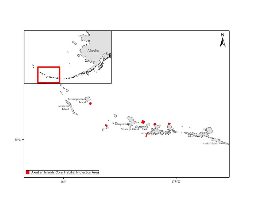
Table 2. --Research projects and anticipated support by the NOAA Deep-Sea Coral Research and Technology
           Program’s Alaska Deep-Sea Coral and Sponge Initiative in 2020-2023........................................................................... 27

DELIVERABLES AND PRODUCTS .......................................................................................................... 28
           Table 3. --Data products generated by expeditions and small projects of the Alaska Deep-Sea Coral and Sponge
           Initiative in 2020-2023. ................................................................................................................................................... 28

CONTRIBUTIONS TO THE BROADER COMMUNITY .............................................................................. 29
   LIST OF DESIRED SAMPLES AND DATA TO SUPPORT EXTERNAL RESEARCH................................................................................ 29
   OPPORTUNITIES FOR UNDERGRADUATE AND GRADUATE STUDENTS ....................................................................................... 29
   OUTREACH TO SCIENCE AND PUBLIC COMMUNITIES ............................................................................................................ 29
       Fishing Communities and Management Organizations ..................................................................................... 29
       Scientific Community .......................................................................................................................................... 30
       General Public .................................................................................................................................................... 30

ROLES AND RESPONSIBILITIES ............................................................................................................ 31
           Table 4. --Roles and responsibilities of the science team and primary outside partners of the NOAA Deep-Sea Coral
           Research and Technology Program’s Alaska Deep-Sea Coral and Sponge Initiative in 2020-2023. ................................ 31

BUDGET ............................................................................................................................................. 34
ACKNOWLEDGMENTS ........................................................................................................................ 34
CITATIONS ......................................................................................................................................... 35
APPENDICES....................................................................................................................................... 41
   APPENDIX A. --CRUISE DATA DELIVERABLES GUIDE ............................................................................................................ 41
   APPENDIX B.--DATA SUBMISSIONS ................................................................................................................................. 45

                                                                                         iv
Introduction
The National Oceanic and Atmospheric Administration (NOAA) Deep Sea Coral
Research and Technology Program (DSCRTP) Objectives
Deep-sea corals and sponges (DSCS) can live for hundreds or thousands of years, creating important
biogenic habitats and supporting remarkably complex communities in deep waters around the globe
(Hourigan et al. 2017, Roberts et al. 2009). Their habitat ranges from 6 m to more than 6,000 m below
the ocean surface. In U. S. waters, deep-sea corals and sponges exist on continental shelves, slopes,
canyons, and seamounts. Their full geographic extent is still unknown due to extensive seafloor areas
lacking adequate exploration. The complex structures created by corals and sponges provide habitat for
many fish (Husebø et al. 2002) and invertebrate species, including commercially important rockfish,
shrimp, and crab (Auster 2005). In addition to their value as habitat, some deep-sea corals and sponges
produce chemicals of great biomedical potential: https://www.noaa.gov/news/noaa-discovery-of-green-
deep-sea-sponge-shows-promise-for-cancer-research.
The National Oceanic and Atmospheric Administration (NOAA) established the Deep Sea Coral Research
and Technology Program (DSCRTP) under the authority of the Magnuson-Stevens Fishery Conservation
and Management Act (MSA), as reauthorized in 2007. The goal of the DSCRTP is to provide scientific
information needed to manage and protect deep-sea coral and sponge ecosystems throughout the
United States (NOAA 2008, Hourigan 2009). To facilitate this mission, the DSCRTP works with partners to
support multi-year regional fieldwork initiatives and targeted projects centered on conducting new
research, assimilating historic data, and making results public in support of DSCS ecosystem
management. Functionally, the DSCRTP supports a rotating initiative program across each U.S. National
Marine Fisheries Service (NOAA Fisheries) region on an approximate 6-year cycle. The DSCRTP has
funded research initiatives in the U.S. South Atlantic (2009-2011), West Coast (2010-2012, 2018-2021),
Alaska (2012-2014, 2020-2023), Northeast (2013-2015), Pacific Islands (2015-2017), and greater
Southeast (U.S. South Atlantic, Gulf of Mexico and U.S. Caribbean; 2016-2019) regions. The regionally-
led initiatives have included mapping and surveys to understand the spatial distribution of DSCS
habitats, research to understand DSCS life histories and their contributions to biodiversity, habitat
suitability modeling, and assessments of impact of human activities on DSCS. A national-level data
management infrastructure underlies the regional initiatives, assuring DSCRTP-supported data to be
accessible to the public.
Alaska Deep-Sea Coral and Sponge Initiative (AKCSI) Overview
In 2020, the DSCRTP began a four-year Alaska Coral and Sponge Initiative (AKCSI), which will focus on
research in the Gulf of Alaska (GOA), Aleutian Islands (AI), and eastern Bering Sea (EBS) regions. These
regions are under the purview of the North Pacific Fishery Management Council (NPFMC), which is
responsible for managing marine fishery resources, including groundfish and Essential Fish Habitat (EFH;
MSA 2006), such as coral and sponge. To facilitate the initiative, a Steering Committee was created and
is comprised of Principal Investigators (PIs) from the Alaska Fisheries Science Center (AFSC), as well as
participants from the DSCRTP, other NOAA agencies, and Fisheries Oceans Canada (DFO). To establish
research priorities, the AFSC and DSCRTP convened a 4-day workshop on 12-15 May 2020. The
workshop was originally scheduled for Juneau, Alaska, but due to the coronavirus (COVID-19) pandemic,
1the workshop was held virtually. A total of 59 scientists and managers, with relevant expertise from
across Alaska and throughout the United States and Canada, participated in the workshop. Participants
represented numerous NOAA offices, other federal agencies, non-government organizations, the
commercial fishing industry, the Aleut Community of St. Paul Island, Fisheries and Oceans Canada, and
academic institutions, totaling 29 entities. Working in small breakout groups, participants discussed and
identified Alaska DSCS science and management priorities in six topic areas: 1) spatial distribution; 2)
population dynamics, biology, and interactions; 3) diversity and genetics; 4) effects of climate change; 5)
effects of other human impacts; and 6) deep-sea benthic/seafloor habitat mapping. Following the
workshop and a wrap-up discussion with breakout group leads, a report was completed (Hoff et al.
2020) that identified the highest priority research topics and questions.
The AKCSI workshop and subsequent publication formed the basis for proposal solicitations that
addressed the identified research priorities. Steering committee members numerically ranked all
proposals, which formed the framework for this science plan. The purpose of this science plan is to
outline a general strategy for the execution and completion of the most important research activities
conducted under the AKCSI. This science plan is a living document. Details related to the projects will
inevitably change throughout the initiative. However, the plan outlines the general approach and
proposed research. Research projects supported by the 2020-2023 AKCSI will consist of the following:
• Research expeditions that survey, sample, and map DSCS ecosystems throughout the Alaska
region.
• Research projects focused on DSCS data and analyses of survey samples.
• Deliverables that support the goals of AKCSI and DSCRTP.
Alaska Area Descriptions and Research Priorities
The Alaska region comprises seven major ecosystems including the Gulf of Alaska (GOA), Aleutian
Islands (AI), eastern Bering Sea (EBS), northern Bering Sea (NBS), eastern Bering Sea slope (EBSS),
Beaufort Sea, and Chukchi Sea (Fig. 1). Each of the seven regions includes distinct fauna, habitats, and
environmental conditions due to geographic, geologic, and oceanographic features. Indigenous
subsistence fishing has been occurring for at least 8,000 years in Alaska waters (Crowell and Mann
1996); early European records of cod fishing begin in the 1700s. Government regulated fisheries are
documented as early as the 1930s (Fredin 1987).
The North Pacific Fishery Management Council (NPFMC) implemented a fisheries management plan
(FMP) in 1978, which focused primarily on foreign fleet fisheries agreements. Beginning in 1987-1988,
foreign fishing activity ceased in Alaska waters and the NPFMC directed efforts to develop fisheries
management plans for many commercially important, federally regulated groundfish species. Directed
fisheries included Pacific cod, walleye pollock, rockfishes, sablefish, and a variety of flatfishes. Relevant
commercial fishing gear in Alaska includes bottom and pelagic trawls, longline, pots, dingle bar, dredges,
and beam trawls with evidence of nearly all gear-types altering benthic habitats (Wion and
McConnaughey 2000).
2Figure 1. --The seven marine ecosystems of Alaska within the Exclusive Economic Zone (EEZ)
covered by the Alaska Fisheries Science Center (NOAA-NMFS).
The NPFMC also oversees the delineation of essential fish habitat (EFH) to conserve and enhance coral
and sponge ecosystems. Increased influences from climate change and human disturbance threaten
many of these habitats. Corals and sponges are widely and abundantly distributed in Alaska waters with
the AI having some of the densest and most diverse coral and sponge fauna in the world (Stone and
Shotwell 2007). Three regions (GOA, AI, EBS) of Alaska waters support extensive coral and sponge
habitat, with approximately 150 species of coral and more than 200 species of sponges identified.
Gulf of Alaska
The GOA is a semi-enclosed basin with the coast of Alaska to the west, north and east, and open to the
greater North Pacific Ocean to the south. There are numerous bays and inlets intersecting the coast,
with canyons and slope areas occurring in deeper waters. The subarctic gyre and the Alaska Coastal
Current dominate the current systems, which help support the rich benthic and pelagic communities in
the GOA (Stabeno et al. 2004). The GOA benthic habitat substrate is diverse and can be characterized as
3areas of high relief; including bedrock, large boulders, and cobble along the slope; to flat sandy/muddy
areas in bays and fjords. There are also two major seamount chains (Chaytor et al. 2007; Fig. 2):
1) The Kodiak-Bowie (Pratt-Welker) seamount chain stretches from the Aleutian Trench in the
north to Bowie Seamount, west of the Queen Charlotte Islands.
2) The Cobb-Eickelberg seamount chain begins at the Aleutian Trench and extends to the
southeast to Axial Seamount on the Juan de Fuca Ridge.
Since 1987, several regions of the GOA seafloor habitat have had some level of protection from fishing
impacts. For example, in 1998, a Marine Protected Area was designated under GOA Groundfish FMP
Amendment 41 which prohibited trawling in southeast Alaska east of longitude 140°E (Fig. 2). The
180,418-km2 MPA not only met the objective of conserving habitat for rockfish but also had the
additional benefit of protecting vulnerable coral and sponge ecosystems (Witherell and Woodby 2005).
A 4.6 km2 benthic feature, Sitka Pinnacles, was designated a Marine Reserve in 2000 as part of the GOA
Groundfish FMP Amendment 59 the only no-take area in Alaska (Witherell and Woodby 2005). In
addition, habitat areas of particular concern (HAPCs) designate specific EFH as critical to commercially
important fish species. In 2006, 16 seamounts, labeled the Alaska Seamount Habitat Conservation Zone,
became HAPCs with a total combined area of 18,278 km2. Also in 2006, a Gulf of Alaska Coral Habitat
Protection Area HAPC (230 km2) was established west of Cape Ommaney and Fairweather Grounds to
protect expansive thickets of red tree coral (Primnoa pacifica) (Witherell and Woodby 2005; Fig. 2).
Bottom-contact gear (longlines, trawls, pots, dinglebar gear, etc.) is prohibited in five subsets of these
areas totaling 47 km2.
4Figure 2. --Gulf of Alaska coral habitat protections areas, trawl closure zone, and seamount
chains.
Researchers have identified nearly 75 species of deep-sea coral in GOA waters at depths ranging from
6 m in glacial fjords to 5,000 m on seamounts (Stone and Cairns 2020). In addition, an estimated 80+
species of sponges (50 confirmed) are suspected to occur in GOA waters (Stone and Rooper 2017,
Lehnert and Stone 2016). Deep-sea coral and sponge research in GOA waters during the first DSCRTP
Alaska Initiative (2012-2015) included the following:
• Mapping and studying the ecological function of areas with high abundances of P. pacifica.
• Estimating recovery rates and sustainable impact rates for P. pacifica using a landscape ecology
approach.
• Determining the productivity of commercial fishes from coral and non‐coral habitats.
• Developing and testing the feasibility of using a towed/drift camera system to estimate the
effects of commercial long‐line and pot fishing on deep‐sea coral and sponge communities.
• Collecting long‐term data sets of oxygen and pH from bottom trawl surveys.
• Establishing a long‐term coral monitoring station at a shallow‐water fjord in Southeast Alaska.
5• Improving the taxonomy and conducting studies on paleo climatology, reproductive ecology, and
trophic dynamics of corals and sponges.
• Compiling a geologically based substrate map.
Aleutian Islands
The Aleutian–Commander Island archipelago forms a boundary between the North Pacific Ocean and
the EBS. The archipelago contains more than 300 islands and extends over 3,000 km from the Alaska
Peninsula in the east to the Russian Kamchatka Peninsula in the west. The U.S. portion of the chain runs
from Unimak Island in the east to Attu Island in the west, a distance of over 1,900 km. The Aleutian
Ridge is a volcanic arc with more than 20 active volcanoes and frequent earthquake activity formed
along zones of convergence between the North American Plate and other oceanic plates. The shelf is
very narrow and drops precipitously on the North Pacific Ocean side, to depths of more than 6,000 m in
the Aleutian Trench. The AI benthic habitat substrate is diverse, but is dominated by areas of high relief
including pinnacles, bedrock, large boulders, and cobble interspersed with volcanic sand patches.
In 1993, National Marine Fisheries Service (NMFS) designated critical habitat for endangered Steller sea
lions (SSL) based on their rookeries and foraging habitats in the AI. Critical habitat designation created
no-entry buffer zones to protect SSL from disturbances such as fishing (Witherell and Woodby 2005). An
unintended potential effect of identifying these critical habitats is that coral and sponge communities in
these areas also escape disturbance. Submersible observations have found areas with complex coral and
sponge communities within the areas encompassed by the SSL critical habitat (Witherell and Woodby
2005). In 2006, the Aleutian Islands Coral Habitat Protection Areas became a HAPC due to the
prevalence of especially high densities of corals and sponges known as “coral gardens”. The protected
area encompasses 377.3 km2 of benthic habitat and is closed to all bottom contact fishing gear (Stone
and Shotwell 2007, Witherell and Woodby 2005).
The Aleutian Islands support the most abundant and diverse coral assemblages in all of Alaska and
possibly in the North Pacific Ocean. Almost 100 species of coral have been reported from AI waters with
57 species likely endemic to the region (Stone and Cairns 2020). Data from AFSC groundfish bottom
trawl surveys indicate that a distinct shift in coral diversity may occur between the eastern and western
AI, beginning at approximate latitude 169° W (Stone and Shotwell 2007). In general, many coral species
may have a broader depth (and therefore habitat) distribution in AI waters than other parts of their
range. Sponges are a major component of living habitat in AI waters with over 100 species identified
(Stone et al. 2011) and many more yet to be recognized. Deep-sea coral and sponge research in AI
waters during the first AKCSI (2012-2015) included the following:
• Determining the distribution of high abundance and diversity areas of deep‐sea corals and
sponges through modeling and field surveys using towed/drift cameras.
• Collecting long‐term data sets of oxygen and pH from bottom trawl surveys.
• Improving the taxonomy and conducting studies on paleo climatology, reproductive ecology,
and trophic dynamics of corals and sponges.
• Compiling a geologically-based substrate map.
6Eastern Bering Sea
The Eastern Bering Sea (EBS) is a large water mass that covers multiple ecosystems including the
southeastern EBS shelf region, the northern EBS shelf, and the EBS slope region. The EBS is bounded by
the Alaska coast to the east, the AI to the south, the Russian Kamchatka peninsula (RKP) and the Bering
Strait region to the north, and the RKP to the west. The EBS benthic habitat is predominantly a flat sandy
to muddy bottom across the shelf region and upper slope with areas of boulder fields and rocky ledges
in areas along the slope, especially in steep canyon faces.
In 1995, a large area in the south central EBS was established as the Red King Crab Savings Area totaling
13,720 km2 to protect adult red king crab, Paralithodes camtschaticus, and their benthic habitat. To
further conserve and protect juvenile red king crab, the adjacent Nearshore Bristol Bay Closure Area
encompassing an additional 65,107 km2 was established and closed to all trawling. These protections
include an area of extremely high density of an abundant single sponge species, Suberites montalbidus,
on the EBS shelf. In 1995, the 24,010 km2 Pribilof Islands Habitat Conservation Area was created by BSAI
Groundfish FMP Amendment 21a, and the area was permanently closed to all trawling and dredging
year-round to protect habitat for juvenile blue king crab, Paralithodes platypus, and forage fish for
marine mammals and seabirds, and to maintain a stable ecosystem in the surrounding habitats. In
addition, habitat in the EBS totaling 3,087 km2 was set aside as walrus haul-out area, protecting not only
walruses but also the invertebrates that form the benthic habitat of that area.
Coral abundance is low in the EBS due to the scarcity of habitat (< 3% hard substrate) preferred by most
corals other than sea pens. Directed studies (Sigler et al. 2015) and bottom trawl groundfish surveys
(Hoff 2016, Conner et al. 2017) show the slope and outer shelf has significantly more coral species than
the inner shelf but densities and coral biodiversity are low when compared to the adjacent AI region. A
directed inventory study of sponges in the EBS during 2013-2015 demonstrated that this assemblage is
much more diverse than previously believed for the EBS with > 75 species of demosponge alone and
many species newly recognized to the EBS (Stone et al. 2019). This inventory study showed that the
sponge taxa in the EBS (demosponges plus unidentified hexactinellid sponges) total more than twice
currently known for the GOA and approximately half as many as the AI region.
The AKCSI conducted a significant field study in 2014 based on a request from the NPFMC to validate
areas of coral concentrations for possible management measures for the conservation and management
of deep-sea corals in Pribilof and Zhemchug canyons. A towed drift camera study was conducted at 250
random locations across the EBS slope and outer shelf examining coral abundance, diversity, size, and
fish habitat associations. Researchers concluded that corals were predominantly located along the EBS
outer continental slope edge from Pribilof Canyon to the southern part of Zhemchug Canyon. Sponge
distribution was widely scattered along the EBS outer shelf and upper slope. They also concluded that
canyons themselves were not the determining factor for coral distribution, but depth, latitude, and
sediment type were more correlated with coral and sponge distributions (Sigler et al. 2015). Deep-sea
coral and sponge research in EBS waters during the previous AKCSI (2012-2015) included the following:
7• Determining the distribution of high abundance and diversity areas of deep‐sea corals and
sponges in the EBS outer shelf and slope region focusing on canyons through modeling and field
surveys using towed/drift cameras.
• Collecting long‐term data sets of oxygen and pH from bottom trawl surveys.
AKCSI Objectives
The objective of the 2020-23 AKCSI is to support research that addresses management needs and
contributes to the conservation and protection of DSCS throughout the sub-Arctic waters of Alaska. This
scientific research plan strives to address the information needed to understand and conserve
important DSCS habitats and to leverage additional partnerships to integrate research priorities and
resources. A focus is on field research and collection of new information on DSCS taxonomy,
distribution, diversity, and life history, as well as natural and induced habitat changes. Specifically,
research will address the priorities identified in the AKCSI priorities workshop report (Hoff et al. 2020).
Approach
To accomplish the objective, the AKCSI Steering Committee will align identified research priorities from
the workshop with proposed projects. They will examine previously conducted coral and sponge
research in Alaska and consult with scientists, NPFMC, industry stakeholders and local communities
periodically as new or changing priorities develop. A combination of chartered commercial vessels,
research cruises on NOAA ships and commercial vessels, and partnerships with federal, state, and Non-
Government Organizations (NGO) partners will be used to accomplish the fieldwork goals and
objectives.
The AKCSI will map, survey, and sample deep-water habitats. The information collected will be
synthesized into products accessible to a broad audience and effectively communicated both internally
and externally. Throughout the AKCSI, regular communication between the initiative’s science team, the
NPFMC, the AFSC directorate, and the DSCRTP will ensure that the initiative provides a real contribution
to the management and informed protection of deep-sea coral and sponge ecosystems throughout
Alaska.
Criteria for Prioritizing Projects
Research priorities for the 2021-2023 AKCSI were identified using a combination of research and
management priorities. Projects addressing the priorities identified at the workshop were solicited from
steering committee members and other principal investigators. Overall, six research priorities guided
the development of the AKCSI science plan:
• Model validation of Gulf of Alaska coral and sponge distribution models using visual surveys that
collect environmental and spatially-explicit biological data.
• Mapping of untrawlable habitats in the Gulf of Alaska and Aleutian Islands.
• Collection of life history information on corals and sponges to support population modeling.
• Use of eDNA for species distribution modelling and biodiversity studies, and other genetic
techniques for taxonomy and connectivity modelling.
8• Development of risk assessment models for corals and sponges in the GOA, AI, and EBS that take
into account anthropogenic and climate effects.
• Investigation of recovery and susceptibility rates of corals and sponges to anthropogenic
activities.
Given limited budget and ranking priorities, the AKCSI PIs will closely assess each project to provide the
best use of resources to achieve the research goals. Higher priority projects a) address research
priorities identified during the May 2020 workshop, b) have achievable goals and objectives in the
available project time frame and c) have relevance to fisheries management and regional priorities.
Work Plan of Activities Supported by the AKCSI
Similar to previous DSCRTP initiatives in other regions, activities supported by the AKCSI will consist of
the following:
• Research expeditions that survey, sample and map DSCS ecosystems.
• Research projects focused on analyzing DSCS data or samples.
Research expeditions and projects that will be supported by the AKCSI are summarized in Tables 1 and 2.
AFSC field activities were greatly reduced in 2020 with the advent of the COVID-19 pandemic. The quick
rise in positive cases of the virus and the lack of knowledge about the virus, transmission, and effective
treatments, made it difficult to create detailed effective travel and at sea safety plans. This resulted in
cancelation of many of the surveys and research cruises scheduled to occur in Alaska (NOAA, United
States Coast Guard, and National Science Foundation). Since May 2020, the NOAA Office of Marine and
Aviation Operations (OMAO), AFSC, and many Alaska commercial fishing companies, have developed
COVID-19 safety plans. These plans provide protocols for enhancement of safety at-sea operations
including testing, quarantine, daily symptom monitoring and other operating procedures. However,
there are still many remaining uncertainties that could affect fieldwork plans for 2021.
Given this uncertainty and the rapidly changing situation associated with COVID-19, the AKCSI PIs
propose a reduced survey effort in 2021 to minimize the risk of lost time, effort, funding, and
opportunities to fulfill the science plan. To accomplish this, research fieldwork will be minimized in 2021
to a 30-day GOA model validation cruise and a 3-4 day cruise to recover coral settlement plates. Both
cruises require minimal scientists and vessel crew, limiting personnel involved. A larger effort with more
sea days is planned for 2022.
Alternatively, if the AFSC remains in lockdown or travel and field research is limited in 2021, the AKCSI
will focus on annotations of existing videos from previous Alaskan studies, continue sponge and coral
field identification guide development, and work with in-hand specimens of coral and sponges for
genetic, taxonomic, and life history studies.
9Research Expeditions (Large, Vessel-Based Projects)
AKCSI research expeditions will conduct visual surveys to collect quantitative data to characterize DSCS
communities and map deep-sea habitats. Specifically, visual surveys will collect data on the abundance,
diversity, and distribution of DSCS communities. AKCSI research expeditions will also collect data on
human impacts to coral and sponge ecosystems and gather biological data on coral and sponge
reproduction, recruitment, and growth. Environmental DNA (eDNA) samples will be collected on
research expeditions and be used to make presence/absence comparisons with visual observations of
coral, sponge, and fish.
Subsequent to analyses, images, and other data (environmental, navigation and mapping) will be
archived at the NOAA National Centers for Environmental Information (NCEI). Observations of corals and
sponges will be archived and distributed through NOAA’s National Database of Deep-Sea Corals and
Sponges. Efforts will be made to conduct data analyses while at sea or immediately following research
expeditions, and complete these no later than one year following expeditions. All expeditions are
planned to be conducted in 2021-2022 (Table 1), so that efforts in the last year of the initiative (2023)
can focus on summarizing results and report writing. If field expeditions need to be modified or canceled
due to weather or COVID-19 pandemic, the possibility remains to shift some projects to other years or
extend the AKCSI into 2024.
Validation of Coral and Sponge Distribution Modeling in the Gulf of Alaska
Investigators: Patrick Malecha NOAA, Gerald Hoff NOAA, Chris Rooper DFO Canada, Pam Goddard NOAA
Affiliate, Rachel Wilborn NOAA Affiliate, Kresimir Williams NOAA, John Olson NOAA, Sean Rooney NOAA
Background and Justification
Effective management of deep-sea coral and sponge ecosystems in Alaska requires presence-absence,
diversity, and abundance knowledge. The immensity of Alaska’s marine waters necessitates the
development of predictive models to best determine where sponges and corals are likely located, since
not every site can be explored given available time and resources. Therefore, a systematic and analytical
approach is needed to determine where coral and sponge ecosystems exist. This approach should
accurately predict DSC presence or absence, diversity, and abundance. An important accomplishment of
the previous AKCSI was the production of maps that predicted occurrence of DSCS on a 1 ha scale for
each of the three major regions of Alaska -- the eastern Bering Sea, Aleutian Islands and Gulf of Alaska
(Rooper et al. 2017, Rooper et al. 2014, Sigler et al. 2015). The maps and models created for the eastern
Bering Sea (Rooper et al. 2016) and Aleutian Islands (Rooper et al. 2017) have been validated with visual
observations in the field that confirmed that coral and sponge ecosystems occur at predictable locations
where hard bottom substrate is present. The maps and models created for the Gulf of Alaska, based on
trawl survey data, have not been validated with visual surveys. In 2021, a major component of analysis
and fieldwork is designed to address this critical informational need. The objectives of this expedition
are to collect density and size estimates for DSCS at randomly selected sites in the Gulf of Alaska and
document species associations with fish and other invertebrates.
10Design and Approach
Visual surveys will be conducted at 300 randomly selected stations in the Gulf of Alaska. The survey
design will be stratified by depth, trawlability of the seafloor habitats (both untrawlable and trawlable
sites will be surveyed), and model predictions of species presence and will occur from ~30 to ~900 m. At
each station, we will deploy a stereo camera system and collect 15 minutes of on-bottom imagery from
a random starting point, drifting with the prevailing current. Images will be analyzed by identifying and
measuring (using stereoscopy) benthic invertebrates and fishes for determining the presence or absence
of sponge and coral, species identifications, abundance, and size. Seafloor substrate type will also be
recorded. Additionally, ES60 acoustic data that may be used to infer seafloor characteristics, water
temperature data, and vessel trackline, depth and position data, will also be collected. In situ water
samples will used for eDNA analyses that will be compared with the visual observations of corals,
sponges, and fish.
Proposed Activities and Deliverables
Post-processing of seafloor images will begin as soon as the data are available and will be completed by
the end of 2022. Post-cruise image analysis will be conducted to determine substrate types, DSCS
species composition, density, and height. In 2023, products completed will also include the development
of validated species distribution models/maps for the GOA using seafloor imagery, coral and sponge size
data, and potentially eDNA presence/absence data. Species associations between benthic invertebrates
and commercially important fishes will also be determined from both visual and eDNA observations.
Should there be any unanticipated delays or fieldwork is not advised in 2021, the fieldwork can be
postponed until 2022.
Assessing the Effectiveness of Area Closures for Maintaining Healthy Deep-Sea Coral and
Sponge Communities
Investigators: Gerald Hoff NOAA, Patrick Malecha NOAA, Chris Rooper DFO, Kresimir Williams NOAA
Background and Justification
Alaska is home to some of the world’s most diverse and abundant deep-sea corals and sponges (Stone
and Shotwell 2007). The Aleutian Islands in particular are home to over 95 coral species representing 22
families (R. Stone, AFSC; personal communication) and over 100 species of sponges in four classes
(Stone et al. 2011, Lehnert and Stone 2016), as well as some of the densest coral and sponge
communities. Many commercially important fishes, including Pacific ocean perch and Atka mackerel, are
associated with coral and sponge communities in the Aleutian Islands and throughout Alaska (Heifetz
2002, Malecha et al. 2005, Rooper and Boldt 2005, Rooper et al. 2007, Laman et al. 2015). In addition,
coral and sponge communities are vulnerable to damage and removal by fishing gear (van Dolah et al.
1987, Auster et al. 1996, Heifetz et al. 2009, Tittensor et al. 2010). The recovery of damaged or removed
communities may take decades or longer, since corals are long-lived and slow growing (Andrews et al.
2002, Andrews et al. 2009, Rooper et al. 2011).
11Commercial fishing in the AI using bottom trawls, pelagic trawls, longlines, and pots target species such
as Pacific cod, Atka mackerel, rockfish species, sablefish, golden king crabs, and halibut. In 2006, partly
in response to concerns about vulnerability of coral communities to commercial fishing, area closures to
mobile bottom contact gear were implemented throughout the Aleutian Islands. The closures effectively
froze the footprint of the existing commercial fisheries. Additional areas identified as “coral gardens”
(Stone et al. 2006) were also designated as closed to fishing. These fishing closures were implemented
specifically to protect coral habitat (Fig. 3).
Figure 3. --Aleutian Islands coral habitat protection areas established in 2006 prohibit all
types of fishing within the designated areas.
In addition to the coral habitat closures, other fishing closures to protect critical habitat for Steller sea
lions have also been in place since 2003 (Fig. 4). These closures have been placed around rookery and
important haul-out sites. Although they were not designed to protect coral habitat, they have effectively
been refugia for benthic communities. Recent changes in regulations implemented in 2015 have
resulted in changes for some boundaries of these Steller sea lion closures. These changes have allowed
bottom trawling to occur within previously closed areas.
12Figure 4. --Map of the Aleutian Islands showing habitat conservation area closures put in
place in 2006, and the progression of fishing closures put in place in pre-2011,
2011 through 2014, and 2015 to present to protect Steller sea lions.
Since 2000, AFSC researchers have been conducting investigations of coral and sponge communities in
the Aleutian Islands. These studies have used existing data from fisheries-independent bottom trawls to
produce predictions of the distribution of coral and sponge communities (Rooper et al. 2014). The
distribution modeling indicates that about half of the predicted coral habitat in the Aleutian Islands was
protected from mobile bottom contact gear in the 2006 closure. The distribution modeling also
highlighted areas of predicted high coral diversity and abundance near Seguam Pass, Kiska Island, and
the area south of Amchitka Island. In 2012 and 2014, an underwater camera survey was conducted at
random sites in the Aleutian Islands to verify model predictions (Rooper et al. 2017). This field study
showed that areas of high-density coral were found throughout the Aleutian Islands and generally
verified model predictions from bottom trawl survey data. Analysis of the underwater camera survey
data further indicated that substrate type and availability of hard substrate were the primary factors
determining the presence and abundance of corals (Goddard et al. 2017, Wilborn et al. 2018). These
results were all consistent with previous research in the eastern Bering Sea (Sigler et al. 2015, Goddard
13et al. 2016, Rooper et al. 2016). Importantly, the use of stereo-camera systems in the field study allowed
collection of precise height information for corals (n > 6,000 individual colonies) observed in the
Aleutian Islands, which provided estimates of the size structure of these populations by region, depth
and habitat type. This data collection may be the first of its type from U.S. waters.
Two fundamental questions regarding coral habitat in the Aleutian Islands are as follows:
1) Is size, species composition, and incidence of injury of coral and sponge communities different
between areas of mobile fishing gear closures versus where mobile fishing gear is allowed?
2) Is there evidence of recovery from fishing damage to coral and sponge communities within
closures implemented in 2006?
The effectiveness of fishing closures implemented in 2006 has been identified as an “important (near
term)” research priority for the North Pacific Fishery Management Council (Research Priority #184 -
Evaluate efficacy of habitat closure areas and habitat recovery). This research project will seek to answer
both of these questions using a combination of a new field study, vessel monitoring system data from
the commercial fishery, and population parameters from literature studies. At the end of the study, we
will synthesize these data sources to produce a stock assessment for corals in the Aleutian Islands that
will provide preliminary estimates of sustainable bycatch rates for these communities. This would be the
first stock assessment of coral in Alaska and perhaps the first for any northern temperate waters.
Design and Approach
The objectives of this project are to evaluate the effectiveness of fisheries closures to protect benthic
habitat in the Aleutian Islands and western Gulf of Alaska. Specifically, we will address the following:
• Compare densities of corals and sponges in areas that were closed to mobile bottom contact
gear to adjacent open areas where mobile bottom contact fishing has occurred since 2003 or
2005.
• Compare size structure of corals and sponges in closed and open areas.
• Compare incidence rates of damaged versus undamaged corals and sponges observed in closed
and open areas and examine evidence of fishing in these areas.
• Examine patterns in fishing effort from vessel monitoring system (VMS) data and compare these
to terrain metrics such as slope, depth and ruggedness to determine common habitat features
among fished areas.
• Use available size data and estimates of growth rates from the literature to make the first
estimate of sustainable harvest rates for corals in the Aleutian Island.
A field study to collect data will be conducted in summer 2022 at nine study locations. These study
locations have been identified as having high densities of coral and sponge (> 1 colonies/ha) at multiple
transects during the 2012 and 2014 underwater camera surveys (Wilborn et al. 2018). In addition to
having high densities of corals and sponges, the nine selected sites are all located in areas that have
adjacent bottom trawl tows targeting Pacific cod, Atka mackerel, or Pacific ocean perch. Ten or fifteen
transect locations will be placed at each of the nine study sites, evenly split among areas closed to
14fishing, areas with reduced fishing, and areas having continuous fishing (n = 5 per treatment) or evenly
split among no fishing and reduced (n = 5 per treatment). To account for potential confounding factors,
the depth ranges and substrate classifications for each treatment will be the same. For example, at a site
where fishing is occurring over cobble-boulder habitats at 150-200 m depths, only the same types of
habitat from non-fishing areas will be used for comparisons.
At each transect, the sampling tool will be a stereo drop-camera system (Rooper et al. 2016, Goddard
et al. 2016, Wilborn et al. 2018) deployed from a chartered vessel. The stereo drop-camera system will
be deployed to the seafloor and then will be towed or drifted along a transect with the prevailing
current for 15 minutes of on-bottom time. Based on the sampling rate from 2012 and 2014, it is
anticipated that ~10-15 transects can be sampled per day in the field using the stereo drop-camera in a
concentrated area such as the study sites. Thus, approximately 12 days of survey time (including 1 day
of mobilization and 1 day of demobilization) will be necessary to complete the project (~10-15 transects
per day with a maximum of 125 total transects). Post-cruise image analysis will be conducted to
determine substrate types, species abundance and individual target size.
Statistical analysis of the data will be completed using parametric tests such as analysis of variance and
linear modeling. In addition to the tests of our main hypotheses, the data collected from transects will
also be used to compute measures of diversity (the number of families or species of coral and sponge
observed in each treatment). Community analyses looking at differences in community structure, such
as ANOSIM, NMDS, and co-occurrence matrices will also be computed to examine any significant
differences in the communities of corals and sponges among the treatments. Data collected during this
study will be combined with data from previous AFSC studies and literature values to compute a simple
biomass dynamic model of coral in the Aleutian Islands. Additionally, size data from stereo camera
observations from this study and the 2012 and 2014 surveys will allow us to construct a population size
structure for corals in the Aleutian Islands. Using size data and growth rates available for Alaska corals
(Andrews et al. 2002, Andrews et al. 2009, Stone et al. 2017), we will improve our estimates of
population recovery rates using coral size structures in the Aleutian Islands and literature-derived
growth rates (Quinn and Deriso 1999). Sensitivity analyses will be conducted on all parameter values in
the model. These sensitivity analyses will be used to place confidence intervals around important model
parameters, and to determine where future research should be focused to reduce the uncertainty in
population models for coral.
Since coral abundance and fishing effort are not uniformly distributed across the Aleutian Islands, we
will include a spatial component in our modeling, using the biomass model to project coral population
dynamics on discrete spatial scales. Using a spatially-explicit population model and including information
on the seafloor characteristics that are important to fishing will allow some evaluation of the effects of
future (and recent) management activities. A parallel analysis will model sponge population dynamics
using the same techniques and the same types of data and modeling.
15Proposed Activities and Deliverables
In 2022, a 14-day research expedition will occur in the Aleutian Islands area. This project will advance
our knowledge of the effectiveness of existing mobile fishing gear closures by comparing coral and
sponge populations within open and closed areas. The coral and sponge population modeling will
provide information that could inform management decisions regarding the sustainability of current
area closures. The population modeling will also be a tool to evaluate future changes in management
and commercial fishing activity. In 2022-23, we anticipate delivering 1) two peer-reviewed manuscripts
(one describing the effectiveness of open and closed areas at maintaining coral and sponge density, size,
and community structure and one describing the coral and sponge population modeling and spatial
modeling component), and 2) reporting of the findings to the NPFMC for potential incorporation into
fisheries management policy (Plan Teams, Ecosystem Committee, and Scientific and Statistical
Committee).
Joint Canada – USA Seamount Exploration in the Eastern North Pacific Ocean (SEENPO)
Investigators: DFO Canada: Chris Rooper, Janelle Curtis, Tammy Norgard, Cherisse Dupreez; NOAA USA:
Gerald Hoff, Patrick Malecha
Background and Justification
Deep-sea coral and sponge distributions in United States, Canada, and international waters are relatively
under-explored, with the exception of a number of studies conducted at the Cobb Seamount complex
off Washington and southern British Columbia, and exploratory dives at two seamounts (Murray and
Pratt) in the Gulf of Alaska. The fauna of deep-sea coral and sponge ecosystems changes with latitude,
so that many of the species of coral and sponge in Alaska are different (and more diverse) than those
found on the continental shelf of British Columbia and the U.S. west coast. The SGaan-Kinghlas (Bowie)
and Cobb hot spot trails form a potential geological connection between the British Columbia
continental shelf and the Alaska continental shelf that may exhibit latitudinal changes in deep-sea coral
and sponge distribution and diversity. Partnering with Canada to understand the biogeography of
seamount coral and sponge communities both within and outside the EEZ and from Washington to
Alaska will contribute to better comprehension of inter-connectivity along the west coast of North
America.
Historically (1970s-1990s) many of these offshore seamounts were fished by both domestic (Canadian
and USA) and foreign (Russia, Korea, and Japan) fishing fleets. Currently, there is limited fishing at these
seamounts in international waters only by the Canadian Sablefish longline trap fleet. The intersection
between deep-sea coral and sponge distribution and fisheries is an ongoing concern of the North Pacific
Fisheries Commission (NPFC), the Regional Fisheries Management Organization for international waters
of the North Pacific Ocean (www.npfc.int). Both Canada and the United States are parties to the NPFC,
which manages fisheries and is tasked with protecting vulnerable marine ecosystems, including deep-
sea corals and sponges from significant and adverse impacts from fishing.
Thus, there is interest in the SGaan-Kinghlas Bowie and Cobb seamount chains, both in terms of their
biological characteristics and for management issues related to international fisheries. In addition, the
16recently held AKCSI workshop for prioritizing Alaska’s new field initiative identified 1) the distribution of
deep-sea corals and sponges on Gulf of Alaska and wider North Pacific Ocean seamounts and 2) deep-
sea coral and sponge hotspots as a priority for conducting visual surveys. This project could also
potentially address issues of climate change, genetic connectivity among coral populations, historical
fisheries impacts and recovery rates and linkages between fished species and deep-sea corals and
sponges, all of which were identified as priority areas of research for the 2020-2023 AKCSI. This project
will also support the Canadian objective to collect baseline comparative data from seamounts outside
Canada’s marine protected areas that are still potentially experiencing fishing pressures.
Design and Approach
The fieldwork proposed here is designed to provide an assessment of the distribution of corals and
sponges on a region-wide scale for seamounts of the North Pacific Ocean using visual survey tools in
areas that have been previously unexplored. This fieldwork is proposed as a collaboration between
Canada and the USA, with each providing support for the research.
The primary objective of this work will be to conduct a visual survey of eight seamounts (Fig. 5) in the
SGaan-Kinghlas Bowie (4) and Cobb (4) seamount chains to determine the density, size, species
composition, and diversity of deep-sea corals and sponges on the seamounts. In addition, visual survey
will allow the collection of data on associated fish and invertebrate species and observe any damage to
coral and sponge communities by historical fishing. The visual survey will be designed in a robust
statistically sound method so that inferences about the deep-sea coral and sponge communities on
seamounts can be made. This will be aided by the development of a distribution model for these
seamounts using existing data sources derived from both Alaska and Canada.
17You can also read