Reliability Aspects of the German Cadastre* - geodaesie.info
←
→
Page content transcription
If your browser does not render page correctly, please read the page content below
Fachbeitrag Degel, Reliability Aspects of the German Cadastre
Reliability Aspects of the German Cadastre*
Björn Degel
Summary und die Struktur der Katasterverwaltung. Er betrachtet den
The German cadastral system enjoys a good international Inhalt des Liegenschaftskatasters und erläutert das Zusam-
reputation, in particular as it guarantees a high degree of le- menwirken mit dem Grundbuch. Rechtliche und technische
gal certainty. It also sets high technical standards. Focussing Aspekte der Zuverlässigkeit des deutschen Katasters werden
on aspects of reliability, the author gives a short overview on hervorgehoben.
the historical development of the cadastre in Germany and
the administrative structure. He takes a look at the contents Keywords: German cadastre, German land registry, contents
of the cadastre and explains the interaction with the land of the cadastre, coordinate-cadastre, “einwandfreie Vermes-
register. Legal and technical aspects of the reliability of the sung”
German cadastre are highlighted.
Zusammenfassung
Das deutsche Katasterwesen genießt international einen gu- 1 History of the German cadastre
ten Ruf, insbesondere da es ein hohes Maß an Rechtssicher-
heit gewährleistet. Aber auch in technischer Hinsicht setzt es Although the first cadastre was established in 1667 in
hohe Standards. Unter dem Gesichtspunkt der Zuverlässig- Hessen-Darmstadt (Freese 2009), most of the cadastral
keit gibt der Autor einen kurzen Überblick über die histori- systems in Germany were established in consequence of
sche Entwicklung des Liegenschaftskatasters in Deutschland the French Revolution, in order to reach a more fair tax-
ation of real properties (Bauer et al. 2010). In 1807 the
surveying for a parcel-sharp cadastre in the Napoleonic
* This article is based on a presentation at the conference of Empire began but could not be completed during Na-
the Permanent Committee on Cadastre in the European Union poleon’s reign. With the resolutions of the Congress of
in Vienna on 20/21 November 2018 with the title “Let’s Talk Vienna in 1815, national borders in Europe were rede-
About (Legal) Reliability of the Cadastre” fined and French troops had to leave German territory.
Landesamt für Vermessung, Geoinformation und Landentwicklung, Saarbrücken
Fig. 1:
Extract
from a
Prussian
“Urhand
riss”
386 zfv 6/2019 144. Jg. © Wißner-Verlag DOI 10.12902/zfv-0262-2019
Degel, Reliability Aspects of the German Cadastre Fachbeitrag
Landesamt für Vermessung, Geoinformation und Landentwicklung, Saarbrücken
Fig. 2: Extract from a “Bayerische Urkarte”
Even though in some states of the German Confedera- The legislative power for the cadastre was still under the
tion (Deutsche Bund) the French “code civil” stayed in authority of the federal states.
force and in particular the cadastre in Prussia followed This changed in the period of National Socialism. The
the French model very closely. In contrast to the Prussian act on the reorganization of the surveying sector (Gesetz
development Bavarian cadastre e. g. didn’t follow the über die Neuordnung des Vermessungswesens 1934) de-
French model (Stein 2005). While the measured survey clared the cadastre a Reich matter. This so called “Reichs
results of the Prussian original survey were documented kataster” set first German-wide standards. Amongst oth-
in a so-called “Urhandriss” (Fig. 1), the Bavarian cadastre ers, the appraisal of soil, “Bodenschätzung”, became part
was directly mapped into a framework according to the of the cadastre (Gesetz über die Schätzung des Kultur-
plane table method in scales of 1 : 5000 or 1 : 2500, “Bay- bodens 1934) which was the first step into a multi-pur-
erische Urkarte” (Fig. 2), without documenting measured pose-cadastre.
length and angles (Seeberger 2001). By the end of World War II, Germany was divided.
On 1 January 1900, the German Civil Code, “Bürger While the western part became the Federal Republic of
liches Gesetzbuch (BGB)”, entered into force. Along Germany (FRG), the eastern part became the German
with the BGB, the German Land Register Code, “Grund Democratic Republic (GDR). According to Article 70 of
buchordnung” (GBO), also came into effect. The former the German Federal Constitution, “Grundgesetz”, cadas-
tax-cadastre was transformed into a property-cadastre, tre in the FRG became Länder-law again.
as the cadastral map is legally considered a part of the The “Einheitskataster” of the GDR was merged with
land register. This process was confirmed by the Supreme the land register (Krause 2008). At the same time a sep-
Court in 1910 with the sentence of the German Reichs- aration process on land and building ownership was set
gericht. Data of the cadastre then finally participate in in motion and land was transformed into “Volkseigen-
the public faith of the land register (Reichsgericht 1910). tum”. Until the German reunion on 3 October 1990 the
© Wißner-Verlag 144. Jg. 6/2019 zfv 387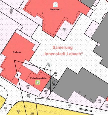
Fachbeitrag Degel, Reliability Aspects of the German Cadastre
“Einheitskataster” has become more and more unusable and Steudle et al. (2015) was in use from about 1980 to
as a property protection system. After the German re- 2015.
union, Western-German cadastre served as a role mod- At the end of 2015, the “Amtliches Liegenschafts
el for the five new Länder. Consequently, cadastre and kataster Informationssystem”, ALKIS®, was established
land register became separated again. A big task was as a new cadastre standard throughout Germany (AdV
the merging of the separated land and building owner- 2019). The core data sets of ALKIS® are cadastral parcels,
ship. Helpful in this process was the land segregation act buildings, owner information, public-law restrictions,
(BoSoG 1993) which allowed quickly forming marketable “Bodenschätzung”, and “Tatsächliche Nutzung” as shown
plots of land (Lucht 2010). in Fig. 3. As geospatial reference data ALKIS® serves as a
multi-purpose-cadastre and is a backbone of the geospa-
tial data infrastructure.
2 Organization of the cadastral administration
The German cadastre lies within the responsibility of the 4 Legal aspects
Länder. Due to this there is no uniform cadastre in formal
terms. Each of the 16 Länder has its own cadastral law. The ownership of the land is documented in the land reg-
While these laws are unified in their general regulations, ister and cadastre. The use of the cadastre as a geomet-
different regulations, especially concerning the respon- rical-legal reference system interlinks the land register
sible authorities, remain (Zeddies 2008). The Working and cadastre. The German property protection system
Committee of the Surveying Authorities of the Länder can be regarded as a special type of “registration of title”
of the Federal Republic of Germany, AdV, as the German in which the two proofs, land register and cadastre, are
umbrella organisation recommends standards on cadas- very closely linked (Rembold 2012). The cadastre is the
tre, state survey and topographic mapping. official register, “Amtliches Verzeichnis”, according to
In contrast to the organization of the German cadas- Article 2 (2) GBO.
tre, legislative power for land registry lies within the “If a landownership right is registered in the land reg-
competences of the German federation. Land register it- istry, the owner is presumed to be entitled to the right.
self is administrated by the Länder. It is maintained by If a registered right is deleted from the land register, it is
legal experts at the local courts. Decisions can only be presumed that the right does not exist”, Article 891 BGB.
overruled by a higher court (Wilsch 2012). Consequently land register and thus cadastre are consid-
ered to be correct until the opposite is proven. Article 892
BGB provides land registry with public faith. The bona
3 Contents of the German cadastre fide acquirer is under special protection.
In order to acquire right to land, a notarized contract,
Property-cadastre contents are the cadastral book as a a notarized conveyance and entry in the land register are
copy of the owner information of the land register, the mandatory. There are only few legally permitted excep-
cadastral map and the set of numbers, “Zahlenwerk”, tions from this rule:
which consists of the documentation of the measure- pp Inheritance law with subsequent correction of the land
ments and the point register with precise coordinates register according to Article 35 GBO;
(Bauer et al. 2010). pp Legally regulated land readjustment according to Ar-
Up to now, the land registry database is not more than ticle 45 to Article 84 Baugesetzbuch (BauGB 2017) or
an auxiliary file. Legally binding however, is the written Flurbereinigungsgesetz (FlurbG 1976);
entry in the land registry. A constant data exchange be- pp Expropriation according to Article 85 to Article 92
tween cadastre and land registry is retained both by means Baugesetzbuch (BauGB 2017);
of analogue and digital data exchange. The Land Regis- pp Compulsory auction before the local court;
ter Database, “Datenbankgrundbuch” (DaBaG), will bring pp Acquisitive prescription after 30 years according ei-
far-reaching changes not only to the GBO (Wilsch 2012) – ther to Article 900 or Article 927 BGB is proved in a
as the DaBaG consists of legally binding database entries complex procedure before the local court;
– but also to the data exchange between cadastre and land pp Abandonment of ownership and appropriation by the
registry. The DaBaG is expected to be launched in 2022. tax authorities according to Articel 928 BGB;
The “Reichskataster” set standards into a multi-pur- pp Correction of an incorrect statement by another proof
pose-cadastre. Up to now “Bodenschätzung” and “Tat of inaccuracy according to Article 22 GBO.
sächliche Nutzung” as a mix of land cover and land use
are part of the cadastre in all German Länder. Depending Combined with the public faith of the land register, these
on the Länder, public law restrictions are, to varying de- strict rules lead to a very high level of legal certainty.
grees, as well provided in the cadastre. Wilsch (2012) gives a detailed view into the German land
The “First generation automated real estate cadaster” register.
as it is described by Ehrmanntraut and Nerkamp (2012)
388 zfv 6/2019 144. Jg. © Wißner-Verlag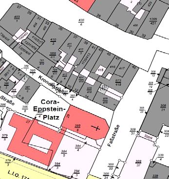
Degel, Reliability Aspects of the German Cadastre                                                Fachbeitrag

         Cadastral Parcels                       Buildings                      Owner Information
  (including precise coordinates)

      Public-Law Restrictions              Tatsächliche Nutzung                  Bodenschätzung
                                              (Mix of LC / LU)

Fig. 3: ALKIS core data based on Steudle, ALKIS – Zukunft gestalten, Nutzer erreichen, INTERGEO 2016

5 Technical aspects                                           ginning of the 20th century property surveying in gener-
                                                              al may be considered as “einwandfrei”.
A legally secure boundary determination requires a relia-        In case of ambiguity and border confusion without
ble cadastre. Some Länder have defined a coordinate-ca-       agreement of the parties involved, a decision of the local
dastre with highly precise and reliable legally binding       court on the border line is necessary. It is not the task of
coordinates of the boundary line. According to the defi-      the cadastral administration to clarify civil law property
nition of the AdV (2002), the coordinate-cadastre is to       issues and to change parcel boundaries with civil law
be understood as a special form of defining boundaries,       effect (Kriesten 2017).
in which point coordinates are determined with high re-          Point coordinates are not necessarily equivalent to the
liability for all boundary points. The standard deviation     graphical coordinates of the cadastral map, even if both
of these coordinates in general is better than 3 cm. As of    are part of ALKIS®. In the 1990s when the digitization
November 2018 the expansion of the coordinate-cadastre        process of the cadastral map began there had been differ-
in these Länder ranges from about 2 % in Saarland to          ent manifestations in different scales of the analogue ca-
92 % in Hamburg.                                              dastral map. E. g. there has been the frame-based cadas-
   Coordinates are not legally binding in the coordinated     tral map scaled 1 : 1000, “Rahmenkarte”, and, following
cadastre or “classical” cadastre. The border has to be de-    the scale and area coverage of the historic Prussian “Ur-
termined according to the neighbourhood principle using       karte”, the so called “Inselkarte”, scaled 1 : 1175, 1 : 1250
the documentation of the measurements. Cadastre is le-        or less in the former Prussian part of Germany. From
gally binding in case of so called “einwandfreie Vermes-      this circumstance and from different digitizing methods
sung” or “einwandfreier Katasternachweis”. This means         results an accuracy between 30 cm and 1 m for the digi-
survey and border points have been clearly determined         tized cadastral map in general.
and thoroughly checked, the parcel boundaries have been          It is the aim of the German cadastral agencies to
legally established and the surveys have been transferred     improve the geometric accuracy of the cadastral map
to the real estate cadastre (VV‑LiegVerm 2017). From be-      through homogenization. The map is moved to the

                                                              © Wißner-Verlag                 144. Jg. 6/2019   zfv   389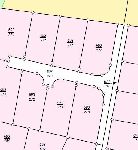
Fachbeitrag Degel, Reliability Aspects of the German Cadastre
c oordinates from point register maintaining the geomet- Rembold, M. (2017): “Hauptsache, dass es fertig werde” – Zur Er-
ric relations (Rembold 2017). neuerung des Liegenschaftskatasters. In: NÖV – Nachrichten
aus dem öffentlichen Vermessungswesen Nordrhein-Westfalen,
Ausgabe 1/2017, S. 26–45.
Rembold, M. (2012): Die Anerkennung und Feststellung von
6 Conclusion Grundstücksgrenzen – Ein Beitrag zur Entwicklung des Liegen-
schaftskatasters im Lande Nordrhein-Westfalen in Vergangen-
Cadastre in Germany lies decentrally within the responsi- heit, Gegenwart und Zukunft. Dissertation. Schriftenreihe des
bility of the Länder. Despite there is no uniform cadastre Instituts für Geodäsie und Geoinformation der Rheinischen
Friedrichs-Wilhelm-Universität Bonn, Heft 27.
in formal terms, it has developed into a precise and high-
Reichsgericht (1910): Urteil vom 12.02.1910, Az.: Rep. V. 72/09. In:
ly reliable part of the German property protection system. Entscheidungen des Reichsgerichts in Zivilsachen (RGZ), Band
It serves as a multi-purpose-cadastre and is a backbone 73, S. 125–131.
of the German geospatial data infrastructure. Seeberger, M. (2001): Wie Bayern vermessen wurde. Hefte zur Bay-
erischen Geschichte und Kultur, Sonderheft 26/01, Haus der
Bayerischen Geschichte, Augsburg.
Stein, W. H. (2005): Die Geschichte des rheinland-pfälzischen
References
Liegenschaftskatasters. In: Nachrichtenblatt der Vermessungs-
AdV – Arbeitsgemeinschaft der Vermessungsverwaltungen der
und Katasterverwaltung Rheinland-Pfalz, Heft 3/2005, 48. Jg.,
Länder der Bundesrepublik Deutschland (2019): Amtliches
S. 160–175.
Liegenschaftskataster Informationssystem (ALKIS®). www.adv-
Steudle, G., Ehrmanntraut, E., Zurhorst, M. (2015): Liegenschafts-
online.de/AAA-Modell/ALKIS/, letzter Zugriff 17.04.2019.
kataster und Liegenschaftsvermessung. In: Kummer, K., Kötter,
AdV – Arbeitsgemeinschaft der Vermessungsverwaltungen der
T., Eichhorn, A. (Hrsg.): Das deutsche Vermessungs- und Geoin-
Länder der Bundesrepublik Deutschland (2002): Profil eines
formationswesen 2015. Wichmann, Berlin, S. 433–519.
zukunftsorientierten Liegenschaftskatasters. www.adv-online.
VV-LiegVerm – Verwaltungsvorschrift für die Durchführung von
de/AdV-Produkte/Liegenschaftskataster/Download/, letzter Zu-
Liegenschaftsvermessungen im Saarland. Verwaltungsvorschrift
griff 17.04.2019.
des Ministeriums für Umwelt und Verbraucherschutz vom 1. Juli
Bauer, R., Püschel, R., Wiedenroth, W., Zurhorst, M. (2010): Liegen-
2017.
schaftskataster und Liegenschaftsvermessung. In: Kummer, K.,
Wilsch, H. (2012): The German “Grundbuchordnung”: History,
Frankenberger, J. (Hrsg.): Das deutsche Vermessungs- und Geo-
Principles and Future about Land Registry in Germany. In: zfv –
informationswesen 2010. Wichmann, Heidelberg, S. 311–378.
Zeitschrift für Geodäsie, Geoinformation und Landmanagement,
BauGB – Baugesetzbuch i. d. F. der Neubekanntmachung vom 3.
Heft 4/2012, 137. Jg., S. 224–233.
November 2017 (BGBl. I S. 3634).
Zeddies, W. (2008): The cadastral system in Germany. In: Overview
BoSoG – Gesetz über die Sonderung unvermessener und überbauter
on the cadastral systems of the E.U. member states. Permanent
Grundstücke nach der Karte (Bodensonderungsgesetz) vom 20.
Committee on Cadastre in the European Union, Edition 2008,
Dezember 1993 (BGBl. I S. 2182, 2215), zuletzt geändert durch
Agenzia del Territorio, Rome, p. 109.
Art. 186 der Verordnung vom 31. August 2015 (BGBl. I S. 1474).
Ehrmanntraut, E., Nerkamp, K.-H. (2012): Konzeption und Nutzung
des automatisiert geführten Liegenschaftskatasters. In: Kummer,
K., Frankenberger, J. (Hrsg.): Das deutsche Vermessungs- und
Contact
Geoinformationswesen 2012. Wichmann, Berlin, S. 137–164.
Dipl.-Ing. Björn Degel
FlurbG – Flurbereinigungsgesetz i. d. F. der Bekanntmachung vom
Landesamt für Vermessung, Geoinformation und Landentwicklung
16. März 1976 (BGBl. I S. 546), zuletzt geändert durch Art. 17
Von der Heydt 22, 66115 Saarbrücken, Germany
des Gesetzes vom 19. Dezember 2008 (BGBl. I S. 2794).
b.degel@lvgl.saarland.de
Freese, A. (2009): Repertorien des hessischen Hauptstaatsarchivs,
Abt. 541. Prüfungsarbeit der Inspektoranwärterin A. Freese,
Hessisches Landesvermessungsamt, Wiesbaden, unveröffentli-
cht.
Gesetz über die Neuordnung des Vermessungswesens vom 3. Juli
1934 (RGBl. I S. 534).
Gesetz über die Schätzung des Kulturbodens vom 16. Oktober 1934 This article also is digitally available under www.geodaesie.info.
(RGBl. I S. 1050).
Krause, F. (2008): Untersuchung der Auswirkungen von festgestell-
ten Widersprüchen zwischen den Nachweisen der ALK und des
ALB am Beispiel der Gemarkung Nossentiner Hütte. Diplomar-
beit zur ALKIS®-Vormigration an der Hochschule Neubranden-
burg – University of Applied Sciences.
Kriesten, M. (2017): Vermessungsrecht, Grenzstreitigkeiten und
Recht der Öffentlich bestellten Vermessungsingenieure. Richard
Boorberg, Stuttgart.
Lucht, H. (2010): Vor 20 Jahren – Aus der Arbeit im Deutschen
Städtetag nach der politischen Wende. In: zfv – Zeitschrift für
Geodäsie, Geoinformation und Landmanagement, Heft 3/2010,
135. Jg., S. 143–151.
390 zfv 6/2019 144. Jg. © Wißner-Verlag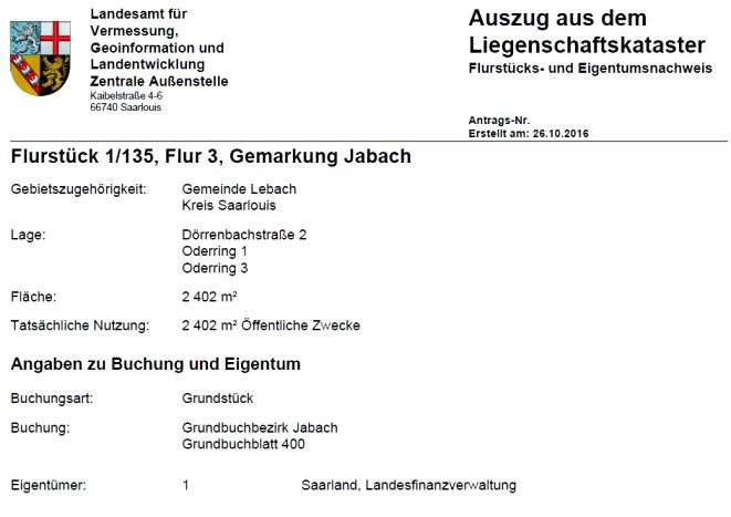
You can also read