Report prepared by Brittney Rogers, SLELO PRISM Aquatic Restoration and Resiliency Coordinator
←
→
Page content transcription
If your browser does not render page correctly, please read the page content below
Report prepared by Brittney Rogers, SLELO PRISM Aquatic Restoration and Resiliency Coordinator
Page | 2
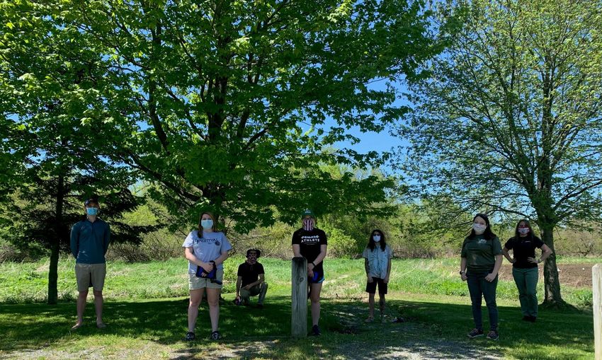
TABLE OF CONTENTS

ACKNOWLEDGEMENTS ................................................................................................................................................ 4
INTRODUCTION .............................................................................................................................................................. 6
   OVERVIEW OF SLELO PRISM ................................................................................................................................... 6
   OVERVIEW OF WATERCRAFT INSPECTION .......................................................................................................... 7
   HISTORY OF WATERCRAFT INSPECTION .............................................................................................................. 8
   OVERVIEW OF THE 2020 REPORT............................................................................................................................ 9
2020 PROGRAM OVERVIEW........................................................................................................................................ 10
SUMMARY OF RESULTS ............................................................................................................................................. 13
PROGRAM OUTREACH AND 2020 STEWARDS ........................................................................................................ 22
CONCLUSION ................................................................................................................................................................ 25
APPENDIX ...................................................................................................................................................................... 26

TABLES, FIGURES AND IMAGES

Table 1 Comprehensive data summary from 2020 WISP .................................................................................................. 13
Table 2 Comprehensive data summary, Watercraft Type .................................................................................................. 14
Table 3 Inspection Summary, Watercraft Encountered while Launching and Retrieving .................................................. 16
Table 4 Spread Prevention Awareness .............................................................................................................................. 18
Table 5 Overview of Registration state and Launch Visitor Travels.................................................................................. 19

Figure 1 SLELO PRISM Core Programming and Special Initiatives .................................................................................. 6
Figure 2 Regional Map of SLELO PRISM in NYS............................................................................................................. 7
Figure 3 Sample of strategic campaigns to build program recognition. ............................................................................... 9
Figure 4 Overview map of SLELO/TILT Steward Launch Coverage................................................................................ 10
Figure 5 Boater contact with Steward and Prevention Awareness ..................................................................................... 17
Figure 6 Waterbodies visited by vessels launching at Lake Bonaparte .............................................................................. 20
Figure 7 Waterbodies visited by vessels launching at Butterfield Lake ............................................................................. 20
Figure 8 Waterbodies visited by vessels launching at Cape Vincent ................................................................................. 21

Image 1 SLELO and TILT Program lead Staff and half of the 2020 Stewards .................................................................. 11
Image 2 Screenshot from virtual training event................................................................................................................. 11
Image 3 Screen Capture of WISPA survey developed for use in Survey 123 .................................................................... 12
Image 4 Images uploaded to WISPA by stewards ............................................................................................................. 15

              St. Lawrence Eastern Lake Ontario Partnership for Regional Invasive Species Management
                          The Nature Conservancy — 269 Ouderkirk Road — Pulaski, NY 13142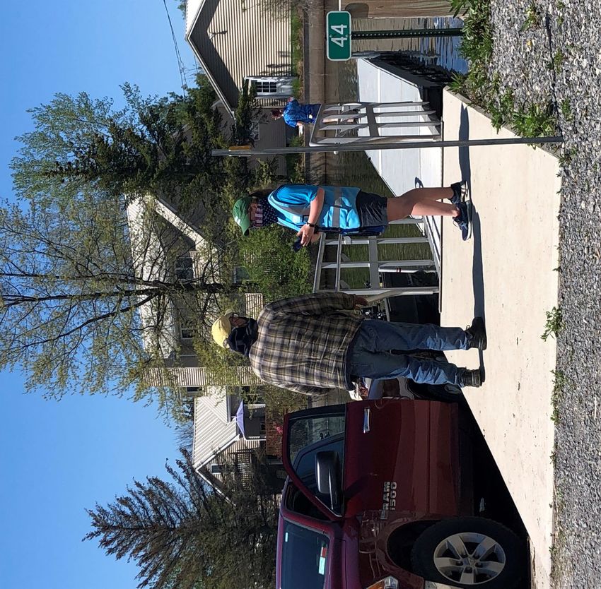
ACKNOWLEDGEMENTS
                                           This report was prepared by:
                                                 Brittney Rogers
                                Aquatic Restoration and Resiliency Coordinator

                                                 Contributions by
                                  Alaina Young, Thousand Islands Land Trust
                               Megan Pistolese, Education/Outreach Coordinator
                               Rob Williams, Invasive Species Program Manager
                       Robert Smith, Terrestrial Restoration and Resiliency Coordinator
                                   Zack Simek, Conservation and GIS Analyst

                                              A Special Thanks To:
                                         The New York State Legislature
           For supporting this program within the New York State Environmental Protection Fund
                                                          -
                                 The Nature Conservancy as Host Organization

                                                          -
                       The New York State Department of Environmental Conservation,
                                     Invasive Species Coordination Section

                                                          -
                             The Thousand Islands Land Trust as co-administrator

The numerous partner organizations and their representatives who contribute their expertise, time and resources to the
      development and success of the SLELO PRISM and the 2020 Watercraft Inspection Steward Program.

                                                                                                               Page | 4
LAUNCH ACKNOWLEDGEMENTS

We would like to acknowledge the support of the following municipalities and organizations for having
     stewards staffed at their launches. Your support is invaluable to the success of this program.

                                            City of Fulton

                                           City of Oswego

                                             City of Rome

                                     New York Power Authority

                                        NYSDEC R6 Fisheries

                                        NYSDEC R6 Forestry

                                        NYSDEC R6 Wildlife

                                        NYSDEC R7 Fisheries

                                             NYSOPRHP

                                        Town of Cape Vincent

                                         Town of Henderson

                                          Town of Massena

                                          Village of Clayton

                                         Village of Heuvelton

                                          Village of Phoenix

                                      Village of Sackets Harbor

                                       Wrights Landing Marina

    St. Lawrence Eastern Lake Ontario Partnership for Regional Invasive Species Management
                The Nature Conservancy — 269 Ouderkirk Road — Pulaski, NY 13142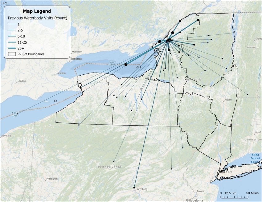
INTRODUCTION

OVERVIEW OF SLELO PRISM

Historical documentation shows Lake Ontario has been and continues to be a destination for fishing enthusiasts,
professional anglers and recreational boating. The Salmon River in Oswego County attracts anglers on a global
scale. Recreational travel-boating is also a significant activity with boaters traveling the Great Lakes, Erie Canal,
Hudson River and even traversing the “Great Loop” which takes vessels from the Great Lakes down through the
Mississippi River around the Florida peninsula up the Atlantic and back into the Great Lakes through the St.
Lawrence River. With more than 7,600 freshwater lakes, including the Great Lakes, Finger Lakes and Adirondack
regions, the potential for aquatic invasive species (AIS) to be spread in New York State is of high concern.

In 2005 the NYS Invasive Species Task Force developed a comprehensive report on invasive species issues in
NY and provided 12 recommendations to the Governor and State Legislature. Among these recommendations
was the development of Partnerships for Regional Invasive Species Management (PRISM). Funded by the
Environmental Protection Fund and administered by the Department of Environmental Conservation
(NYSDEC), NY’s eight PRISMs form a network whose cooperation and activities are vital components of an
integrated, state-wide approach to invasive species management.

The St. Lawrence Eastern Lake Ontario (SLELO) PRISM was established in 2011 and serves Jefferson, Lewis,
Oneida, Oswego, and St. Lawrence counties (Figure 2). The SLELO PRISM, hosted by The Nature
Conservancy, strives to protect native biodiversity and freshwater resources through a collaborative approach to
invasive species management with an emphasis on core programming and multiple special initiatives (Figure 1).

                                                                                Special Initiatives:
                     Core Programming:                                   AIS Macrophyte Nutrient Analysis
                          Prevention                                       Aquatic Restoration Initiative
                        Early Detection                                   Environmental DNA Sampling
                        Rapid Response                                       Pollinator Pathway Project
                    Management and Control                              Spotted Lanternfly Spotters Program
                     Ecological Restoration                                 Tug Hill Forest Restoration
                    Education and Outreach                              Urban Forest Sustainability Initiative
                                                                       Watercraft Inspection Steward Program

Figure 1 SLELO PRISM Core Programming and Special Initiatives

To guide SLELO’s strategic invasive species prevention and management efforts, the PRISM worked with
partner organizations to develop a Tiered Species List, which categorizes species by abundance and
management feasibility within the SLELO region.
                                                                                                                 Page | 6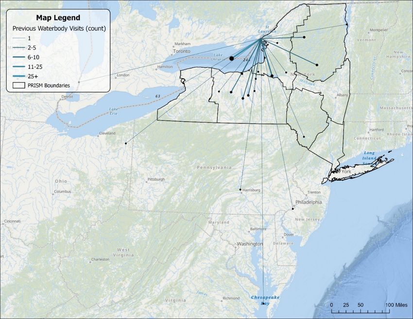
SLELO PRISM is a collaborative effort between numerous principal, at-large and cooperating affiliate partners
throughout the region. Contributions and expertise provided by our partners is the key to our success. Current
partners include;

   •   Algonquin to Adirondacks Collaborative
   •   Central NY Regional Planning and Development Board
   •   Cornell Cooperative Extension
   •   County Soil and Water Conservation Districts
   •   Ducks Unlimited
   •   Fort Drum Military Installation
   •   Indian River Lakes Conservancy
   •   New York Power Authority
   •   New York Sea Grant
   •   NYS Department of Transportation
   •   NYS Office of Parks, Recreation and Historic Preservation
   •   Onondaga Audubon
   •   Save the River
   •   St. Regis Mohawk Tribe
   •   NYS Department of Environmental Conservation
   •   The Nature Conservancy
   •   Thousand Islands Land Trust
   •   Tug Hill Commission
   •   Tug Hill Tomorrow Land Trust
   •   U.S. Coast Guard Auxiliary

                                                                   Figure 2 Regional Map of SLELO PRISM in NYS

The SLELO PRISM, encompassing over four million acres of land, is continually threatened by the introduction
and spread of new or existing invasive species. Since its founding in 2011, the PRISM has made tremendous
progress to prevent the establishment of new species and the mange existing infestations to mitigate their
impacts within the PRISM. Watercraft inspection is one of the primary methods to prevent the spread of AIS in
the PRISM.

OVERVIEW OF WATERCRAFT INSPECTION

The goal of the Watercraft Inspection Steward Program (WISP) is for trained stewards to engage the public,
specifically boaters, on how to look for and remove aquatic invasive species from their boating and fishing
equipment. This program is designed to equip stakeholders with information that can help them reduce the
potential spread of aquatic invasive species in the absence of stewards, while also collecting important data on
where boaters are travelling, their awareness of AIS and if any organisms are being transported by the
watercraft. Boater participation in the SLELO PRISM WISP is 100% voluntary, though some programs in other
parts of NY are mandatory.

         St. Lawrence Eastern Lake Ontario Partnership for Regional Invasive Species Management
                     The Nature Conservancy — 269 Ouderkirk Road — Pulaski, NY 13142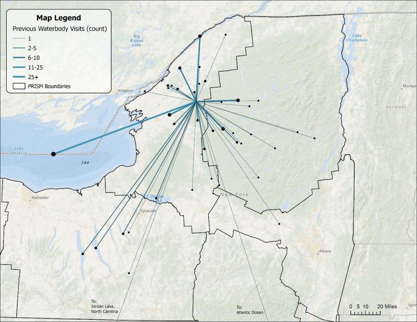
With boaters, the stewards:

   •   Walk through inspection checkpoints using a standardized protocol and survey tool
   •   Engage boaters in dialogue about AIS, their impacts on the environment, and the importance of taking
       measures to prevent their spread
   •   Provide AIS educational materials
   •   Collect boater usage and aquatic invasive species data

HISTORY OF WATERCRAFT INSPECTION

The transportation of aquatic species by recreational watercraft has been clearly established as a primary vector
in the spread of AIS across North America (Leung, Bossenbroek, & Lodge, 2001; Johnson, Ricciardi, & Carlton,
2001; Drury & Rothlisberger, 2008).

Watercraft inspection programs are one of the most cost-effective methods to prevent of spread of AIS. The first
watercraft inspection program in NY was initiated by Paul Smith’s College on the St. Regis Chain of Lakes in
2000. The Lake Champlain Basin Program and the Lake George Association initiated programs in 2007 and 2008,
respectfully. Steward programs in the Finger Lakes and Eastern Lake Ontario began in 2012 and were federally
funded through the Great Lakes Restoration Initiative. In 2014, the New York State Office of Parks, Recreation
and Historic Preservation (NYSOPRHP) received funds through the Great Lakes Restoration Initiative to develop
a boat launch steward program at state managed launches along portions of the Lake Ontario Shoreline. Although
this effort was substantial, partners of the SLELO PRISM, including NYSOPRHP and NYS DEC, identified gaps
for which increased stewardship coverage would benefit the region tremendously.

Through a $100,000 grant from the NYS DEC Invasive Species Spread Prevention Grants Program (NYS
Environmental Protection Fund) in 2016, four AIS stewards were strategically placed at high use, high priority
boat launches along Eastern Lake Ontario in Cape Vincent, Sackets Harbor, Henderson Harbor, and Wrights
Landing in Oswego. Between 2016 and 2018, a total of 2,605 watercraft were inspected across four high-use boat
launch sites adjacent to Lake Ontario. Invasive species were intercepted 230 times over a three-year period.

The NYS AIS Management Plan, released in 2015, called for expanding and standardizing steward programs
across the state (NYSDEC, 2015). In 2018, NYSDEC began funding pilot boat steward programs in each of the
PRISMs across the state. This expansion of the state-wide boat steward programs has allowed SLELO PRISM to
initiate and expand the program in 2020 and through the duration of the contract, expiring in 2023.

State-wide programs have worked together to carefully implement public AIS prevention campaigns. These
campaigns are showing increased public adoption and include the Protect Your Waters and Clean-Drain-Dry

                                                                                                         Page | 8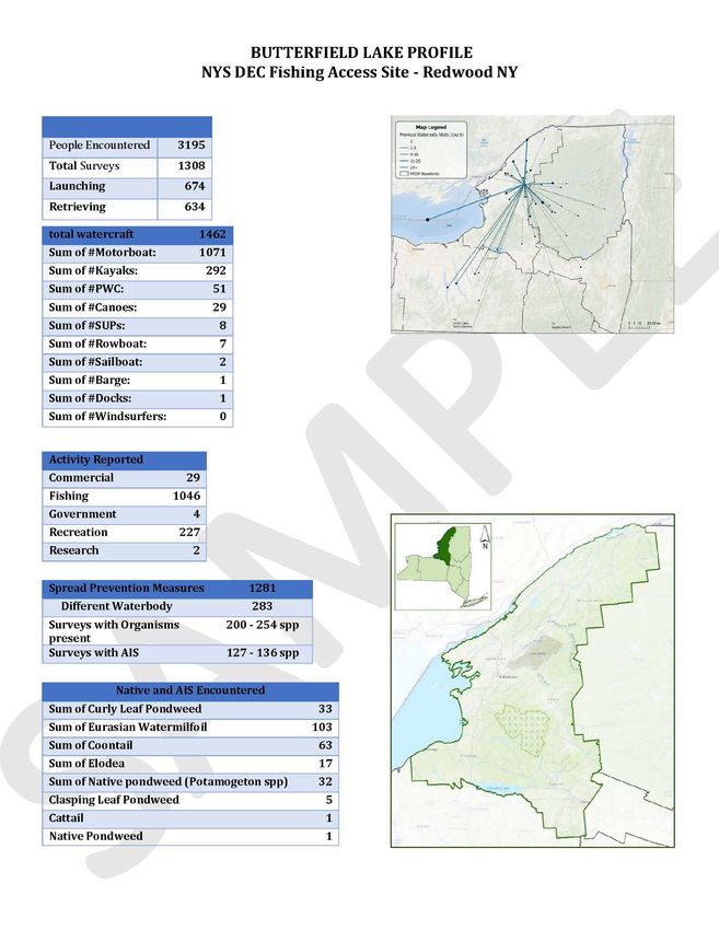
protocol (Figure 3). Campaign and messaging consistency between programs is important to build recognition
and improve public perception of watercraft inspection programs and steward presence at launches.

Figure 3 Sample of strategic campaigns to build program recognition.

OVERVIEW OF THE 2020 REPORT

This report captures the multiple components of SLELO PRISM’s 2020 watercraft inspection program. The
program overview section provides an overview of the training and methods; followed by a summary of results
which interprets the data obtained by the stewards; outreach and staff section regarding the 2020 staff and a
brief recommendation section for programmatic improvements and plans in 2021. Launch Profiles which break
down the data based on location including maps and information about each launch will be found in the
appendix.

           St. Lawrence Eastern Lake Ontario Partnership for Regional Invasive Species Management
                       The Nature Conservancy — 269 Ouderkirk Road — Pulaski, NY 13142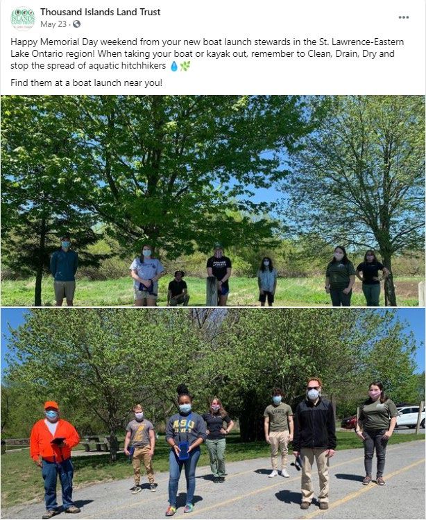
2020 PROGRAM OVERVIEW
In 2020, WISP, administered by SLELO PRISM
and the Thousand Islands Land Trust (TILT), hired
10 stewards to cover 30 launches across the region,
with each steward splitting their time between
multiple sites (Figure 4).

This program expansion contributed to the
statewide effort focusing on preventing and
slowing the spread of AIS. There were nearly 325
launches in NYS with steward coverage in 2019,
and over 248,000 inspections conducted, which
resulted in 12,000 potential invasive species spread
interceptions. In 2020, there were 349,800 records
submitted with 19,122 organisms detected on
watercraft.

The co-administering organization, TILT, works to
conserve the natural beauty, diverse wildlife
habitats, water quality, and outdoor recreation
                                                        Figure 4 Overview map of SLELO/TILT Steward Launch Coverage
opportunities of the 1000 Islands region, for present
and future generations. Since 1985, TILT has helped to safeguard over 10,000 acres of land in Jefferson and St.
Lawrence Counties through conservation easements, land acquisition, and by establishing accessible areas for
public enjoyment (including open spaces for hiking, biking, fishing, hunting, birding, and kayaking).

The 2020 SLELO PRISM and TILT program successfully launched the week before Memorial Day Weekend
and continued to the weekend prior to U.S. Indigenous Peoples’ Day. Unfortunately, similar to many
organization’s projects, COVID-19 changed the way WISP would have traditionally operated. Stewards were
deemed essential by the NYS Governor and were fortunate enough to staff launches, so long as they closely
followed a COVID-19 response plan and updated TILT staff on their health, safety and any potential concerns
related to the pandemic. PPE was provided by NYS DEC, which included masks, gloves and sanitizer. Although
this year was unique for everybody, especially as the pandemic surged throughout the summer, people looked to
the water for a way to escape into nature. Many locals enjoyed the bountiful opportunities of excellent boating,
fishing or general aquatic recreation that the SLELO region has to offer, and the stewards still met visitors from
all over the world.

                                                                                                                      Page | 10
Image 1 SLELO and TILT Program lead Staff and half of the 2020 Stewards, specifically those covering southern launches in SLELO PRISM
Stewards were recruited via job announcements on the TILT website, SLELO website, newspapers and even
social media. The 10 stewards, three of whom were considered returning stewards, were trained virtually via
Zoom Video Communications Inc., May 20-22, 2020. Training sessions included WISP overview, invasive
species identification, communicating with the public and how to use the Survey123 application that is being
used by all programs in NYS. See Appendix for the
full agenda.
Standard launch coverage was 5-days per week
from Wednesday to Sunday, approximately 8:00-
4:30pm with built in breaks. Stewards were
provided a standard uniform including a light blue
T-shirt with SLELO PRISM, TILT and Protect
Your Waters logos and a light blue safety vest.
Each steward was provided with the necessary
supplies to set up an information table with signs,
brochures, handouts, identification guides and
other resources that may expand the information
Image 2 Screenshot from virtual training event including SLELO PRISM staff,
shared regarding AIS and spread prevention. TILT Staff and 10 stewards
St. Lawrence Eastern Lake Ontario Partnership for Regional Invasive Species Management
The Nature Conservancy — 269 Ouderkirk Road — Pulaski, NY 13142Stewards are trained to gather initial data on each launch visitor including party size, type of watercraft, state of
boat registration, and if the watercraft is being launched or retrieved. Once they greet the party, they share
educational information, perform the inspection looking for any plant, animal or mud material and work with the
visitor to remove any material found and drain all compartments that may hold water. While the steward is
engaging the boater, they conduct a short survey, asking the boater if they have visited a waterbody in the previous
two weeks, if they are aware of invasive species, what steps they take specifically to prevent the spread of invasive
species and what waterbody they plan to visit next. All information collected during the survey is recorded into a
Samsung tablet using the Watercraft Inspection Steward Program App (WISPA), which was developed by the NY
Natural Heritage Program using Esri’s Survey 123 application. This standardized survey is used by all WISP
programs across NYS.
Image 3 Screen Capture of WISPA survey developed for use in Survey 123
Page | 12SUMMARY OF RESULTS
The 2020 steward program operated Memorial Day Weekend and continued to the weekend prior to U.S.
Indigenous Peoples’ Day. In total, 27 launches were staffed for 697 shifts, totaling 6,001 hours. During this
time, stewards conducted 10,598 surveys with 95.6% of boaters agreeing to the voluntary inspection (Table 1).
Inspections per site ranged from zero at Bellamy Harbor Park to 1,418 at Lake Bonaparte. Number of visitors at
each site varied depending on weather, typical launch use, and COVID-19. There were 27,375 people engaged
by stewards, many receiving educational materials while the stewards inspected 12,455 watercraft. In instances
when a group had multiple watercraft, for example a group of three kayakers, one survey was collected but each
of the three watercraft were inspected. The busiest launches staffed by stewards in 2020 were Butterfield Lake,
Cape Vincent, Lake Bonaparte and North Sandy Pond. Lake Bonaparte averaged 34 surveys per day while the
other three launches averaged 21-22 surveys per day.
Table 1 Comprehensive data summary from 2020 WISP
Total Count
Total Surveys % of ALL
Launch DAYS % Agreed People Invasive and
Completed SPP AIS
Native Spp.
ButterfieldLake 1308 58 100.0% 3195 254 54%
CapeVincent 1393 63 93.0% 3410 256 41%
DeltaLakeStatePark 580 46 81.7% 1378 0 0%
GodfreyPoint 681 36 81.4% 1560 0 0%
GrassPointStatePark 97 8 96.9% 255 11 55%
HendersonHarbor 506 40 99.0% 1628 148 61%
HeuveltonBoatLaunch 210 49 100.0% 445 1 100%
IndianPointLanding 76 21 100.0% 153 0 0%
KeewaydinStatePark 103 6 99.0% 270 1 100%
LakeBonaparte 1418 41 98.9% 4138 307 79%
MaryStreetBoatLaunch 680 50 96.8% 1627 180 61%
MassenaDamIntake 239 16 100.0% 530 2 0%
MillsiteLake 158 16 100.0% 333 23 87%
MontarioPtRd 96 14 99.0% 330 2 50%
NorthSandyPond 1101 52 98.5% 2998 880 52%
PhoenixBoatlaunch 71 24 100.0% 154 0 0%
PineGrove 113 7 97.3% 295 5 80%
SacketsHarbor 235 29 89.8% 550 18 0%
JacksonRdSalmonRiver 202 16 94.6% 508 3 67%
RedfieldReservoirSalmonRiver 546 27 98.4% 1384 3 33%
SouthSandyCreek 331 27 96.7% 1047 18 0%
SportsmanPool 9 4 100.0% 19 0 0%
ThreeMileBay 118 21 93.2% 289 106 56%
ToadHarbor 7 2 57.1% 9 0 0%
WellseleyIslandStatePark 9 1 100.0% 23 1 100%
WrightsLandingMarina 311 23 99.0% 847 3 100%
Grand Total 10,598 697 95.6% 27,375 2,222 56%
St. Lawrence Eastern Lake Ontario Partnership for Regional Invasive Species Management
The Nature Conservancy — 269 Ouderkirk Road — Pulaski, NY 13142Launches varied in use due to location and accessibility, among other reasons. The primary activity reported to
stewards were to utilize the water for recreation (56%) and fishing (42%). Other purposes included commercial,
research or as part of governmental work. Of the 12,455 total watercraft inspected, 66% were motorboats, 23%
were kayaks and 7% were personal watercrafts (Table 2). The type and quantity of watercraft varied greatly by
location. Some launches, such as South Sandy Creek and Montario Point Road, are better designed for
launching non-motorized watercraft. Kayaks accounted for 87% and 76%, respectively, of all watercraft
surveyed at these locations. Other launches, such as Henderson Harbor and Massena, were mostly visited by
motorboats, accounting for 85% or higher of the watercrafts at these launches. Knowing which watercraft are
encountered most at each launch is important because certain watercraft are more likely to have
organisms found on them. For example, in 2020, 14% of motorboats inspected had organisms on them, while
only 2% of kayaks had organisms on them (Table 3). Organisms encountered varied by launch, boater traffic,
and whether the site had areas where boats are more likely to encounter AIS during navigation.
Table 2 Comprehensive data summary, Watercraft Type
Sum of Total
Launch Motorboat Kayak PWC Canoe SUP Sailboat Rowboat Barge
Watercraft
ButterfieldLake 1462 73.26% 19.97% 3.49% 1.98% 0.55% 0.14% 0.48% 0.07%
CapeVincent 1434 82.85% 5.30% 9.90% 0.70% 0.21% 0.42% 0.63% 0.00%
DeltaLakeStatePark 776 51.42% 41.24% 5.93% 0.77% 0.64% 0.00% 0.00% 0.00%
GodfreyPoint 711 85.51% 9.99% 2.81% 0.28% 1.13% 0.28% 0.00% 0.00%
GrassPointStatePark 113 67.26% 17.70% 13.27% 0.88% 0.88% 0.00% 0.00% 0.00%
HendersonHarbor 516 86.82% 0.78% 11.82% 0.39% 0.00% 0.19% 0.00% 0.00%
Heuvelton 240 63.75% 27.08% 7.08% 2.08% 0.00% 0.00% 0.00% 0.00%
IndianPointLanding 106 28.30% 67.92% 0.00% 3.77% 0.00% 0.00% 0.00% 0.00%
KeewaydinStatePark 107 79.44% 1.87% 18.69% 0.00% 0.00% 0.00% 0.00% 0.00%
LakeBonaparte 1705 62.64% 27.21% 8.21% 1.06% 0.59% 0.06% 0.18% 0.00%
MaryStreetBoatLaunch 695 84.03% 3.02% 12.37% 0.58% 0.00% 0.00% 0.00% 0.00%
MassenaDamIntake 250 87.60% 1.20% 11.20% 0.00% 0.00% 0.00% 0.00% 0.00%
MillsiteLake 223 31.39% 54.71% 1.35% 4.04% 7.17% 0.00% 1.35% 0.00%
MontarioPtRd 192 8.33% 76.04% 0.00% 15.10% 0.52% 0.00% 0.00% 0.00%
NorthSandyPond 1135 83.26% 4.32% 11.81% 0.53% 0.09% 0.00% 0.00% 0.00%
Phoenix 89 42.70% 49.44% 2.25% 3.37% 0.00% 0.00% 1.12% 1.12%
PineGrove 127 66.14% 13.39% 17.32% 1.57% 1.57% 0.00% 0.00% 0.00%
SacketsHarbor 247 73.68% 6.07% 15.38% 1.62% 1.21% 2.02% 0.00% 0.00%
SalmonRiverJackson 262 51.15% 35.11% 6.87% 3.82% 0.76% 1.91% 0.38% 0.00%
SalmonRiverRedfield 609 79.97% 12.64% 4.93% 1.81% 0.33% 0.33% 0.00% 0.00%
SouthSandyCreek 963 0.73% 87.02% 0.00% 9.66% 2.60% 0.00% 0.00% 0.00%
SportsmanPool 9 0.00% 0.00% 0.00% 0.00% 0.00% 0.00% 100.00% 0.00%
ThreeMileBay 122 75.41% 9.84% 12.30% 1.64% 1.64% 0.00% 0.00% 0.00%
ToadHarbor 9 11.11% 88.89% 0.00% 0.00% 0.00% 0.00% 0.00% 0.00%
WellseleyIslandStatePark 9 100.00% 0.00% 0.00% 0.00% 0.00% 0.00% 0.00% 0.00%
WrightsLandingMarina 344 77.91% 15.99% 3.20% 0.58% 2.03% 0.29% 0.00% 0.00%
Grand Total 12455 66.33% 23.16% 7.22% 2.02% 0.77% 0.20% 0.26% 0.02%
Page | 14During each inspection, stewards identified and reported all organisms found. Stewards reported 2,222 native
and invasive species present in 1,291 inspections. Boats with organisms present are considered in this report to
be “dirty”. SLELO defines “dirty” as boats that are transporting any aquatic organisms, including both native
and invasives. Of the 2,222 organisms found, 56% were AIS. Stewards found the highest number of organisms
at North Sandy Pond, Lake Bonaparte, Butterfield Lake and Cape Vincent. This also correlated with the four
launches where stewards conducted the highest number of inspections.
Of the 2,222 observed organisms, the most common invasives found included Eurasian and variable-leaf
watermilfoils (781), curly leaf pondweed (366) and zebra mussels (40). The most common native species
included elodea (312), eel grass (239) and coontail (158). Less common invasive species, though still important,
included European frogbit, brittle naiad, water chestnut and spiny/fishhook water flea. It is essential to track
and remove all organisms encountered, even if they are native, to reduce spread to other waterbodies
beyond the species current range. This program is meant to not only prevent species from entering the waters
in the SLELO region, but to also prevent species from leaving our region. This is especially important for
vessels exiting Lake Ontario, a known high-risk waterbody with over 180 non-native or invasive species
present.
Image 4 Images of aquatic species, which includes invasive Eurasian watermilfoil, curlyleaf pond weed, and native eel grass, elodea and coontail
among others, which were uploaded to WISPA by stewards, Gary and Lauren, found on separate watercraft during inspections
St. Lawrence Eastern Lake Ontario Partnership for Regional Invasive Species Management
The Nature Conservancy — 269 Ouderkirk Road — Pulaski, NY 13142Table 3 Inspection Summary, Watercraft Encountered while Launching and Retrieving
SUMMARY OF WATERCRAFT INSPECTIONS
% OF TOTAL % OF TOTAL % OF TOTAL % OF TOTAL % OF "DIRTY"
TOTAL WATERCRAFT WATERCRAFT WATERCRAFT WATERCRAFT WATERCRAFT
LAUNCHING RETRIEVING "CLEAN" "DIRTY" WITH AIS
Watercraft
12455 61.69% 38.31% 89.22% 10.78% 8.17%
Total
Motorboat 8262 58.15% 41.85% 85.78% 14.22% 11.21%
Kayaks 2885 65.68% 34.32% 97.75% 2.25% 0.52%
PWC 899 76.86% 23.14% 90.10% 9.90% 7.90%
Canoes 252 74.60% 25.40% 96.43% 3.57% 0.79%
SUPs 96 69.79% 30.21% 96.88% 3.13% 1.04%
Sailboat 25 64.00% 36.00% 96.00% 4.00% 4.00%
Rowboat 33 60.61% 39.39% 96.97% 3.03% 3.03%
Barge 2 50.00% 50.00% 100% 0% 0%
Docks 2 100% 0% 100% 0% 0%
INSPECTIONS COMPLETED PRIOR TO LAUNCH
% OF TOTAL
% TYPE OF % LAUNCHING % LAUNCHING % LAUNCHING
TOTAL WATERCRAFT
WATERCRAFT "CLEAN" "DIRTY" “DIRTY” WITH AIS
LAUNCHING
Watercraft
12455 100% 61.69% 96.47% 3.53% 66.05%
Total
Motorboat 8262 66.33% 58.15% 95.19% 4.81% 67.53%
Kayaks 2885 23.16% 65.68% 99.31% 0.69% 7.69%
PWC 899 7.22% 76.86% 96.38% 3.62% 84.00%
Canoes 252 2.02% 74.60% 99.47% 0.53% 0%
SUPs 96 0.77% 69.79% 100% 0.00% 0%
Sailboat 25 0.20% 64.00% 93.75% 6.25% 100%
Rowboat 33 0.26% 60.61% 100% 0% 0%
Barge 2 0.02% 50.00% 100% 0% 0%
Docks 2 0.02% 100% 100% 0% 0%
INSPECTIONS COMPLETED UPON RETRIEVAL
% OF TOTAL
% TYPE OF % RETRIEVING % RETRIEVING % RETRIEVING
TOTAL WATERCRAFT
WATERCRAFT "CLEAN" "DIRTY" “DIRTY” WITH AIS
RETRIEVING
Watercraft
12455 100% 38.31% 77.62% 22.38% 78.46%
Total
Motorboat 8262 66.33% 41.85% 72.82% 27.18% 81.91%
Kayaks 2885 23.16% 34.32% 94.75% 5.25% 26.92%
PWC 899 7.22% 23.14% 69.23% 30.77% 78.13%
Canoes 252 2.02% 25.40% 87.50% 12.50% 25.00%
SUPs 96 0.77% 30.21% 89.66% 10.34% 33.33%
Sailboat 25 0.20% 36.00% 100% 0% 0%
Rowboat 33 0.26% 39.39% 92.31% 7.69% 100%
Barge 2 0.02% 50.00% 100% 0% 0%
Docks 2 0.02% 0% 0% 0% 0%
Page | 16When asked by stewards, 78% of boaters were familiar with AIS spread prevention measures and reported
taking at least one preventative action. Stewards are trained to not lead the boaters toward a particular answer.
For example, when the steward asks if the boater 2020 Boater's Previous Contact with a
has taken any steps to prevent the spread of AIS, Steward and Prevention Awareness
the steward allows the boater to provide the 95%
answer, rather than listing choices for the boater to 90%
say yes or no to. In May, launch users indicated 85%
they used spread prevention measures 70% of the 80%
time, and by September 89% of boaters indicated 75%
they were taking prevention measures, a 19% 70%
increase (Figure 5). Survey data also showed that 65%
as the season progressed, more boaters reported a
60%
previous encounter with a steward and had a higher Previous Contact with a Steward
55%
level of awareness of spread prevention measures. Awareness of Prevention Measures
50%
October was omitted from this analysis as only 22 May June July August September
boats were inspected with only one launch being
Figure 5 Change in boater contact with Steward and Prevention Awareness over
covered. Though boaters are reporting increased time, a 35% increase in boaters who have encountered stewards and a 19%
increase in boater’s awareness of aquatic invasive species prevention measures.
awareness of spread prevention measures, stewards
still encountered organisms on 22.8% of retrieving watercraft and 3.53% of launching watercraft.
Of the 10,598 inspections completed, the most common measures that boaters indicated they were taking
included draining their bilge (5,786), washing (4,290), drying (3,529) and inspecting boats (2,432). The
launches with the highest percentage of awareness and measures being taken included Heuvelton (100%),
Millsite Lake (100%) and Indian Point Landing (99%). The launches with the lowest number of boaters taking
spread prevention measures included Montario Point Road (23%) and Lake Bonaparte (59%). Stewards were
only at Toad Harbor (57%) and Wellesley Island State Park (56%) for 1-2 shifts and it is important to note that
the data may not be representative of the larger population of launch users.
The goal of watercraft inspection is for trained stewards to engage the public, specifically boaters, on
how to look for and remove aquatic invasive species from their boating and fishing equipment.
St. Lawrence Eastern Lake Ontario Partnership for Regional Invasive Species Management
The Nature Conservancy — 269 Ouderkirk Road — Pulaski, NY 13142Table 4 Spread Prevention Awareness
Drain
Total % Drain Drain Dispose
LAUNCH Wash Dry Inspect Bait Decon
Surveys Yes Bilge Livewell Of Bait
Bucket
ButterfieldLake 1308 98% 984 1 1274 19 2
CapeVincent 1393 73% 958 785 532 5 593 87 84 14
DeltaLakeStatePark 580 81% 230 295 368 3 29 2 4 1
GodfreyPoint 681 81% 312 428 394 28 64 3 3 2
GrassPointStatePark 97 79% 73 70 73 10 65 29 29
HendersonHarbor 506 74% 310 96 40 15 86 109 132 2
Heuvelton 210 100% 207 209
IndianPointLanding 76 99% 42 22 27
KeewaydinStatePark 103 86% 85 84 88 11 81 19 20
LakeBonaparte 1418 59% 374 685 463 41 87 2 9
MaryStreet 680 73% 475 447 440 101 428 210 202 4
MassenaDamIntake 239 87% 192 202 1
MillsiteLake 158 100% 64 1 157
MontarioPtRd 96 23% 3 15 4 1 3 5
NorthSandyPond 1101 75% 545 420 386 169 183 90 89 3
Phoenix 71 96% 56 11 12
PineGrove 113 94% 99 45 48 17 31 18 16
SacketsHarbor 235 60% 54 131 128 41 1 1
SalmonRiverJacksonRd 202 90% 171 53 84 18 51 37 31
SalmonRiverRedfield 546 94% 503 151 179 64 185 118 107 1
SouthSandyCreek 331 65% 1 190 201
SportsmanPool 9 89% 8
ThreeMileBay 118 68% 69 49 34 52 15 14 1
ToadHarbor 7 57% 4
WellseleyIslandSP 9 56% 5 1 2 5 3 3
WrightsLanding 311 97% 64 247 26 68 32 19 17
Grand Total 10598 78% 5786 4290 3529 2432 2033 765 756 40
The data collected showed that of the 7,683 boats launching, 259 were launching “dirty” or had organisms
present. As part of the survey, boaters are asked if their boat had been in the water in the past two weeks, and if
so, where, because this increases the risk of species being spread to different waters as they may still be viable
during that time period. Survey data indicated that 21.6% of “dirty” boats launching in our region had
previously been in another waterbody within the last two weeks. This includes boaters with watercraft
registered to numerous states including, New York, Pennsylvania, New Jersey, and Virginia. Many of these
boaters also indicated they did not take any efforts to prevent the spread of invasive species. It is important to
understand where boaters have traveled from to better assess what species could potentially be introduced and
which waters are at the highest risk of new species introduction. The following maps (Figure 5-7) show
locations visited by launching vessels within two weeks of inspection for SLELOs three busiest and “dirtiest”
launches.
Page | 18Table 5 Overview of Registration state and Launch Visitor Travels
Different Same Unknown if No Spread Unknown if
Row Labels Total Launching Retrieving Waterbody Waterbody vessel was Prevention Efforts were
Previously Previously elsewhere Efforts taken
ButterfieldLake 1308 674 634 283 277 748 10 17
CapeVincent 1393 711 682 90 409 894 294 84
DeltaLakeStatePark 580 261 319 1 171 408 8 101
GodfreyPoint 681 213 468 3 150 528 10 117
GrassPointStatePark 97 65 32 7 46 44 11 9
HendersonHarbor 506 393 113 4 203 299 120 12
Heuvelton 210 163 47 152 58 1
IndianPointLanding 76 49 27 44 32 1
KeewaydinStatePark 103 63 40 13 32 58 11 3
LakeBonaparte 1418 941 477 161 449 808 566 16
MaryStreet 680 488 192 58 272 350 124 60
MassenaDamIntake 239 168 71 1 147 91 18 12
MillsiteLaked 158 87 71 51 18 89 0
MontarioPtRd 96 86 10 36 60 67 7
NorthSandyPond 1101 739 362 139 418 544 253 27
Phoenix 71 48 23 1 40 30 3 0
PineGroveSLELO 113 86 27 30 33 50 3 4
SacketsHarbor 235 158 77 10 98 127 79 16
SalmonRiverJacksonRd 202 126 76 26 63 113 11 9
SalmonRiverRedfield 546 348 198 70 191 285 16 17
SouthSandyCreek 331 267 64 14 128 189 104 11
SportsmanPool 9 9 0 0 9 0 1 0
ThreeMileBay 118 63 55 8 37 73 26 12
ToadHarbor 7 5 2 1 6 3
WellseleyIsland 9 8 1 2 2 5 4 0
WrightsLanding 311 192 119 8 161 142 2 7
Grand Total 10598 6411 4187 980 3587 6031 1741 546
Figure 6 Registration
state/province of watercraft
inspected by SLELO / TILT
stewards in 2020.
Note: Registration state is not
indicative of potential for AIS
introduction and/or spread and
only representative of where
boats are registered to.
St. Lawrence Eastern Lake Ontario Partnership for Regional Invasive Species Management
The Nature Conservancy — 269 Ouderkirk Road — Pulaski, NY 13142Figure 7 Waterbodies
visited by vessels
launching at Lake
Bonaparte Public Boat
Launch (Harrisville NY)
within two weeks of
inspection. Not featured
on map: 450 vessels
reported prior visits to
the destination
waterbody (Lake
Bonaparte) and 16
vessels reported previous
launch date/location as
unknown. An additional
316 vessels launching at
Lake Bonaparte did not
visit any waterbodies
within the past two
weeks.
Figure 8 Waterbodies
visited by vessels
launching at Butterfield
Lake Fishing Access Site
(Alexandria NY) within
two weeks of inspection.
Not featured on map: 277
vessels reported prior
visits to the destination
waterbody (Butterfield
Lake) and 34 vessels
reported previous launch
date/location as unknown.
An additional 82 vessels
launching at Lake
Bonaparte did not visit
any waterbodies within
the past two weeks.
Page | 20Figure 9 Waterbodies
visited by vessels
launching at Cape
Vincent municipal launch
on the St. Lawrence River
within two weeks of
inspection. Not featured
on map: 409 vessels
reported prior visits to the
destination waterbody
(Cape Vincent) and 30
vessels reported previous
launch date/location as
unknown. An additional
183 vessels launching at
Cape Vincent did not visit
any waterbodies within
the past two weeks.
Boaters were also asked what waterbody they planned to visit next. In total, 104 different locations were
disclosed. The most frequently reported waterbodies that aren’t within the SLELO PRISM include;
Cayuga Lake Keuka Lake
Cranberry Lake Lake Champlain
Stillwater Reservoir Lake George
Lake Erie Owasco Lake
Fourth Lake Potomac River
Brantingham Lake Raquette Lake
The surrounding areas mentioned include Quebec, Finger Lakes, Buffalo, Ohio, Pennsylvania, New Jersey and
Maine, though no exact waterbodies were shared.
St. Lawrence Eastern Lake Ontario Partnership for Regional Invasive Species Management
The Nature Conservancy — 269 Ouderkirk Road — Pulaski, NY 13142PROGRAM OUTREACH AND 2020 STEWARDS
The SLELO PRISM has developed a webpage to host information regarding the WISP, which includes
highlights from the past programs, reports and resources with more information on watercraft inspection and
AIS. This page is periodically updated, visit www.sleloinvasives.org/watercraftinspection for more
information.
As part of the continued collaboration, both hosting organizations created and shared multiple posts and articles
with the public regarding the 2020 Watercraft Inspection Steward Program. The Thousand Islands Land Trust
Facebook page shared 14 posts about the 2020 program, reaching 9,808 people with 686 engagements. The job
description webpage on TILT’s website had 302 views. In addition, SLELO PRISM shared six posts, reaching
1,060 people with 165 engagements. Periodic posts and updates can be found on
www.facebook.com/sleloprisminvasives throughout the season.
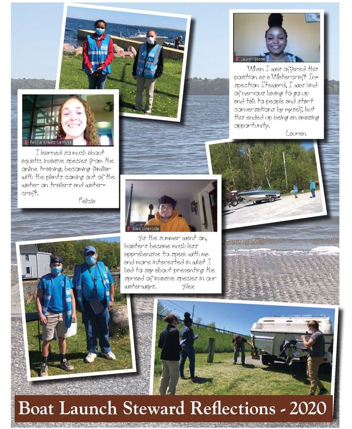
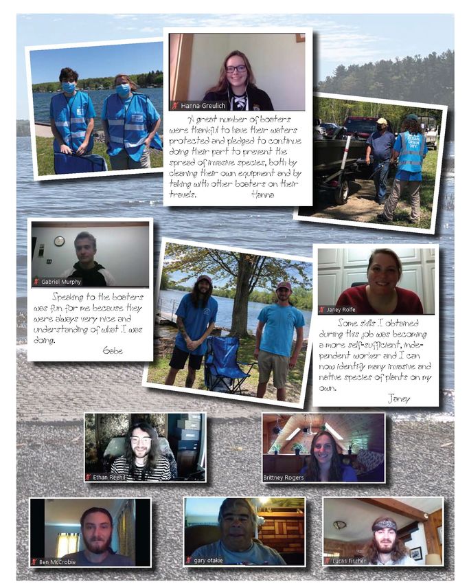
The following pages include highlights of social media posts and steward reflections submitted as part of their
closing interviews and shared in the TILT newsletter.
Page | 22Thousand Islands Land Trust Newsletter 2020
St. Lawrence Eastern Lake Ontario Partnership for Regional Invasive Species Management
The Nature Conservancy — 269 Ouderkirk Road — Pulaski, NY 13142Schooling for this line of work is fascinating, but you
cannot get a real appreciation for it until you are out and
doing the work. I hope that after schooling, I can find
work that gives me the same feeling of joy that comes with
this. Both TILT and SLELO PRISM were great to work
for, and it was such a fun experience to see all the people
being able to enjoy our waterways. Because of that, it
makes me happy that there are people out in the world
trying their best to protect it, and I got to be part of that.
Lucas
Page | 24CONCLUSION
SLELO PRISM is committed to preventing and slowing the spread of AIS in to and out of our region. Even as
the pandemic surged, our stewards were able to communicate with nearly 30,000 people the importance of
slowing the spread of invasive species. This year, the program showcased the region-wide expansion to increase
coverage across the SLELO PRISM, enhanced the already strong partnership with the Thousand Islands Land
Trust and continued to collaborate with other largescale programs in surrounding regions, including the
Adirondack Watershed Institute and Finger Lakes PRISM among others, to enhance standardization and
improve program practices.
For 2021, we plan to improve steward training using detailed employee feedback and information collected
during the season. In hope that the pandemic will slow, SLELO and TILT are also planning to increase outreach
and education programming beyond the launches to include steward presence at events such as Invasive Species
Awareness Week and the SLELO PRISM Invasive Species Symposium. It would be beneficial to begin
exploring the possibility of constructing decontamination stations at the launches with the highest visitor
volume, organisms found during inspections, and with visitors who travel the most frequently. When surveyed,
76% of visitors indicated they would use a decontamination station if one was available.
During the 2021 field season, SLELO will hold more frequent steward staff meetings to increase opportunities
for information exchange and professional development by inviting outside professionals to share their work.
The stewards hired as part of this program need to have the skills to communicate with the public in an outgoing
and friendly way, must be mature and responsible enough to work in remote areas while unsupervised and be
dedicated to and enthusiastic about the work they are conducting. SLELO strives to find the best fit staff for
each launch and find ways to benefit both the program and the steward professionally.
SLELO PRISM is appreciative of the continued support of partnering organizations, agencies, municipalities
and stakeholders who all play a role in protecting the lands and waters on which all life depends from the threat
of aquatic invasive species.
St. Lawrence Eastern Lake Ontario Partnership for Regional Invasive Species Management
The Nature Conservancy — 269 Ouderkirk Road — Pulaski, NY 13142APPENDIX
BIBLIOGRAPHY
Drury, K., & Rothlisberger, J. (2008). Offense and defense in landscape-level invasion control. Oikos, 117, 182-
190.
Johnson, L. E., Ricciardi, A., & Carlton, J. T. (2001). Overland Dispersal of Aquatic Invasive Species: A Risk
Assessment of Transient Recreational Boating. Ecological Applications, 11(6), 1789-1799.
Leung, B., Bossenbroek, J., & Lodge, D. (2001). Boats, pathways, and aquatic biological invasions: Estimating
dispersal potential with gravity models. Ecological Applications, 11, 1778-1788.
NYSDEC Bureau of Fisheries. (2015). New York State Aquatic Invasive Species Management Plan. New York
State Department of Environmental Conservation, Division of Fish Wildlife and Marine Resources. Albany:
New York State.
Rothlisberger, J., Chadderton, W., McNulty, J., & Lodge, D. (2010). Aquatic invasive species transport via
trailered boats: What is being moved, who is moving it, and what can be done. Fisheries, 35(3), 121-132.
Page | 26TRAINING AGENDA
St. Lawrence Eastern Lake Ontario Partnership for Regional Invasive Species Management
The Nature Conservancy — 269 Ouderkirk Road — Pulaski, NY 131422020 LAUNCH PROFILES
Launch Profiles will be released in 2021.
Page | 28ADDITIONAL DATA TABLES
Varia
Curly Attac Zebr Brit
Eurasian Eel ble- Nati Fr Water Spiny/Fish
Leaf Elod Coon Potamog hed a tle Bladder
LAUNCH Watermi Gra leaf ve og Chest hook
Pondw ea tail eton spp. Debri Mus naia wort
lfoil ss Milfoi lily bit nut Waterflea
eed s sel d
l
ButterfieldLake 103 33 9 0 63 32 0 0 0 0 0 0 0 0 0
CapeVincent 63 27 16 90 0 13 31 9 6 0 0 0 0 0 0
DeltaLakeStatePa
rk
0 0 0 0 0 0 0 0 0 0 0 0 0 0 0
GodfreyPoint 0 0 0 0 0 0 0 0 0 0 0 0 0 0 0
GrassPointStateP
ark
0 6 0 0 0 1 3 0 0 0 0 0 0 0 0
HendersonHarbo
r
31 59 57 1 0 0 0 0 0 0 0 0 0 0 0
Heuvelton 0 1 0 0 0 0 0 0 0 0 0 0 0 0 0
IndianPointLandi
ng
0 0 0 0 0 0 0 0 0 0 0 0 0 0 0
KeewaydinStateP
ark
0 1 0 0 0 0 0 0 0 0 0 0 0 0 0
LakeBonaparte 207 5 8 13 11 8 0 28 2 1 1 0 0 0 0
MaryStreet 27 82 44 19 0 1 6 0 0 0 0 0 0 0 0
MassenaDamInta
ke
0 0 0 0 0 0 0 0 0 0 0 0 0 0 0
MillsiteLake 18 0 0 0 0 3 0 0 0 0 1 1 0 0 0
MontarioPtRd 0 1 1 0 0 0 0 0 0 0 0 0 0 0 0
NorthSandyPond 305 118 164 102 80 32 1 3 32 20 1 1 2 1 0
Phoenix 0 0 0 0 0 0 0 0 0 0 0 0 0 0 0
PineGrove 3 1 1 0 0 0 0 0 0 0 0 0 0 0 0
SacketsHarbor 0 0 0 0 3 0 15 0 0 0 0 0 0 0 0
SalmonRiverJack
sonRd
1 1 0 0 0 1 0 0 0 0 0 0 0 0 0
SalmonRiverRedf
ield
1 0 0 0 0 0 0 0 0 1 0 0 0 0 0
SouthSandyCree
k
0 0 0 0 0 0 18 0 0 0 0 0 0 0 0
SportsmanPool
ThreeMileBay 22 28 12 14 1 8 11 9 0 0 0 0 0 0 0
ToadHarbor
WellseleyIslandSt
atePark
0 1 0 0 0 0 0 0 0 0 0 0 0 0 0
WrightsLanding
Marina
0 2 0 0 0 0 0 0 0 0 0 0 0 0 1
Grand Total 781 366 312 239 158 99 85 49 40 22 3 2 2 1 1
St. Lawrence Eastern Lake Ontario Partnership for Regional Invasive Species Management
The Nature Conservancy — 269 Ouderkirk Road — Pulaski, NY 13142Page | 30
You can also read