Revitalizing Mumbai Textile Mill Lands for the City
←
→
Page content transcription
If your browser does not render page correctly, please read the page content below
University of Massachusetts - Amherst
ScholarWorks@UMass Amherst
Masters Theses 1896 - February 2014                                                                              Dissertations and Theses

2011

Revitalizing Mumbai Textile Mill Lands for the
City
Vinay Surve
University of Massachusetts - Amherst, vsurve@art.umass.edu

Follow this and additional works at: http://scholarworks.umass.edu/theses

Surve, Vinay, "Revitalizing Mumbai Textile Mill Lands for the City" (). Masters Theses 1896 -
February 2014. Paper 722.
http://scholarworks.umass.edu/theses/722

This Open Access is brought to you for free and open access by the Dissertations and Theses at ScholarWorks@UMass Amherst. It has been accepted
for inclusion in Masters Theses 1896 - February 2014 by an authorized administrator of ScholarWorks@UMass Amherst. For more information, please
contact scholarworks@library.umass.edu.
Revitalizing Mumbai textile mill lands for the city

                A Dissertation Presented

                           by

                VINAY ARUN SURVE

         Submitted to the Graduate School of the
University of Massachusetts Amherst in partial fulfillment
           of the requirements for the degree of

            MASTER OF ARCHITECTURE

                    September 2011

           Architecture + Design Program
    Department of Art, Architecture and Art History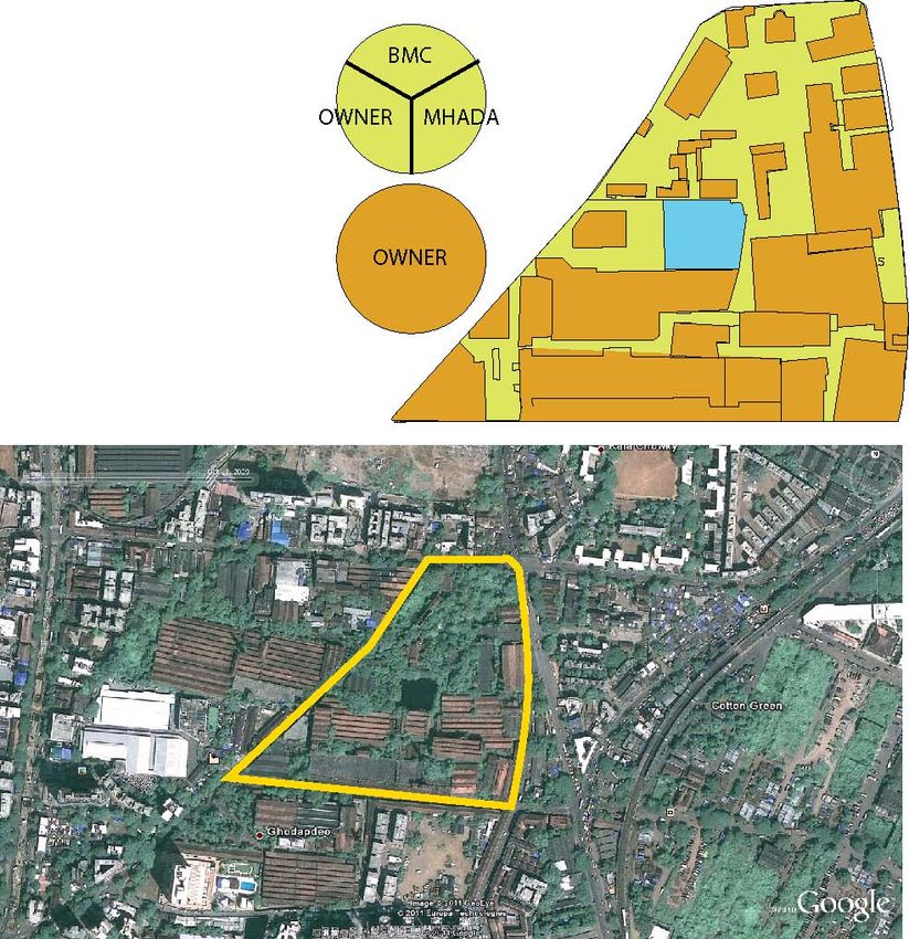
Revitalizing Mumbai textile mill lands for the city

                               A Dissertation Presented

                                          by

                                VINAY ARUN SURVE

Approved as to style and content by:

_______________________________________
Kathleen Lugosch, Chair

_______________________________________
Max Page, Member

_______________________________________
Alexander C. Schreyer, Member

                                           ____________________________________
                                           William T. Oedel,
                                           Chair, Department of Art,
                                           Architecture and Art History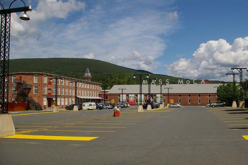
DEDICATION

For my beloved Aai (mother), Bhau (Father), Manish (Brother), Tejas (Brother),

             Bhakti (Sister in law), and Tunnu (Nephew).

                                 And

                        Professor David Dillon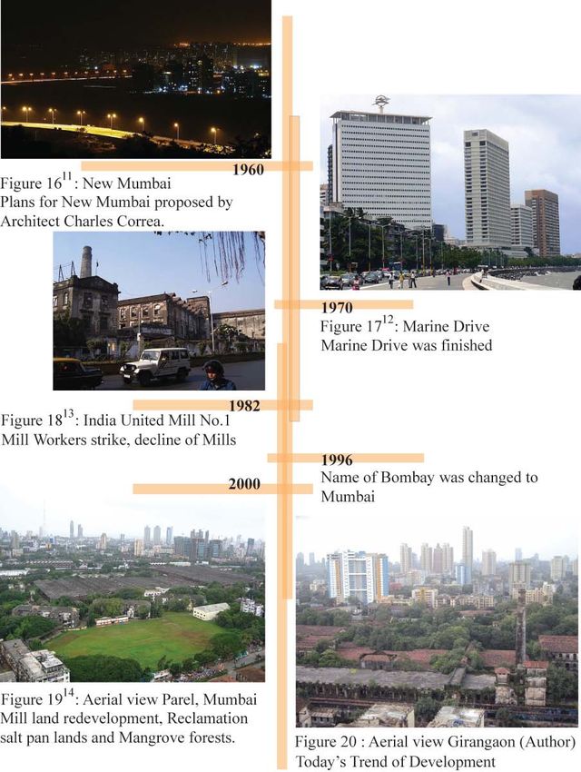
ACKNOWLEDGMENTS

       I would like to start by thanking the institution, UMASS Amherst for providing

every support system in achieving this milestone. This thesis would not have been

possible without late Prof. David Dillon who inspired me to take a stand towards my

thesis topic. I remember his inspiring words when he saw an attitude and energy in my

initial thesis discussions and asked me to maintain that attitude till the end. I owe my

deepest gratitude to my mentor and chair Prof. Kathleen Lugosch for her limitless support

throughout my Masters curriculum. Her understanding, encouraging and constructive

guidance have provided a good basis for developing my thesis.

       I would like to thank my committee members Prof. Alexander C. Schreyer and

Prof. Max Page along with Prof. Joseph Krupczynski and Prof. Skender Luarasi for

providing valuable inputs, suggestions and advice. In addition, I would like to extend my

thanks to Prof. Sigrid Miller and Prof. Caryn Brause for sharing their approach towards a

particular problem in design in their respective studios, which helped me to achieve my

goal towards thesis. Further, I would like to extend my thanks to Prof. Ray K. Mann for

giving me support and opportunity to get hands-on experience in handling a construction

site, which gave me exposure to building construction techniques in cold climates.

       I am very grateful to my mom, dad, brothers and sisters for their continuous

emotional support and incomparable love and care. I owe my deepest gratitude to my

studio mates with whom I shared thoughts, discussions and ideas to shape up my ideas.

Lastly, I offer my regards and blessings to all of those who supported me in any respect

during the completion of the project.

                                           iv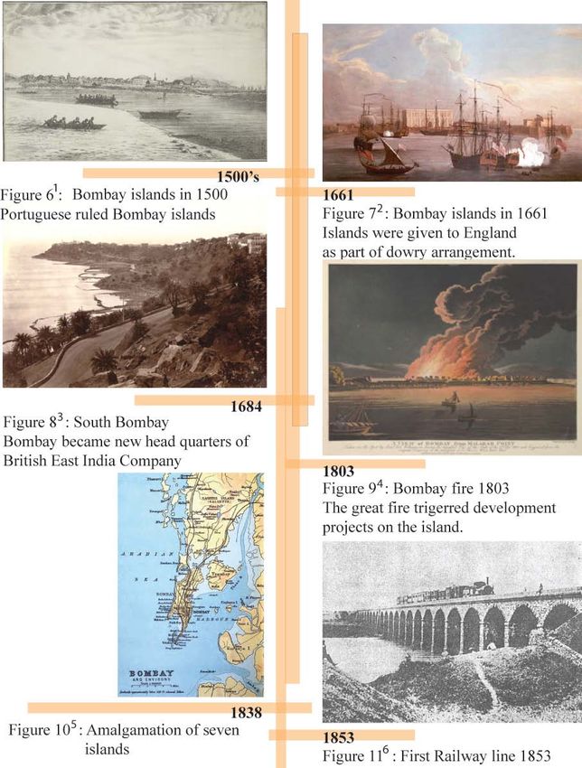
ABSTRACT

      REVITALIZING MUMBAI TEXTILE MILL LANDS FOR THE CITY

                                   SEPTEMBER 2011

                                 VINAY ARUN SURVE

    B.ARCH, PILLAI’S COLLEGE OF ARCHITECTURE, MUMBAI, INDIA

           M.ARCH, UNIVERSITY OF MASSACHUSETTS AMHERST

                       Directed by: Professor Kathleen Lugosch

Cities are always in transition and so the city’s Architecture should respond to it.

Transition brings opportunities of growth, expansion, improvement in social and urban

fabric along with new development strategies. My thesis explores the current trend of

textile mills development in the heart of the city of Mumbai, its drawbacks and proposes

a development plan for a mill premise for the benefit of the city. It is an attempt to

preserve the city’s old fabric, which at one time was a city in itself and merge its fabric

with the new development in a cohesive manner.

       I was looking at the response to the historic city and how you add new work to it

by superimposing or juxtaposing. The success of the building is in its layering, its

discovery by the visitor and its ability to make a public building truly public. My ideas

come from observation: of the site, of nature, of people moving in the city.

                                             v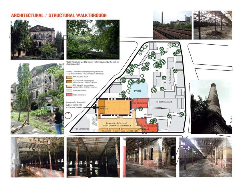
TABLE OF CONTENTS
Page
ACKNOWLEDGMENTS ................................................................................................. iv
ABSTRACT.........................................................................................................................v
LIST OF TABLES ............................................................................................................. vi
LIST OF FIGURES ........................................................................................................... ix
CHAPTER
1. STATEMENT OF INTENT ....................................................................................1
2. MUMBAI - GEOGRAPHY ....................................................................................5
3. MUMBAI - COLONIAL .........................................................................................8
4. MUMBAI - TIMELINE ........................................................................................10
5. MUMBAI - THEN AND TODAY ........................................................................14
6. MUMBAI - URBAN .............................................................................................16
7. MUMBAI - URBAN AND ENVIRONMENTAL ISSUES ..................................19
8. GIRANGAON - THE MILL PRECINCT .............................................................22
9. DECLINE OF THE TEXTILE MILLS .................................................................30
10. REDEVELOPMENT OF TEXTILE MILL LANDS ............................................33
11. CHARLES CORREA STUDY GROUP REPORT ...............................................35
12. TODAY'S TREND OF DEVELOPMENT ON MILL LANDS ............................39
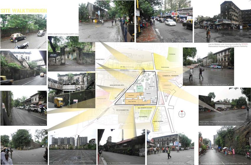
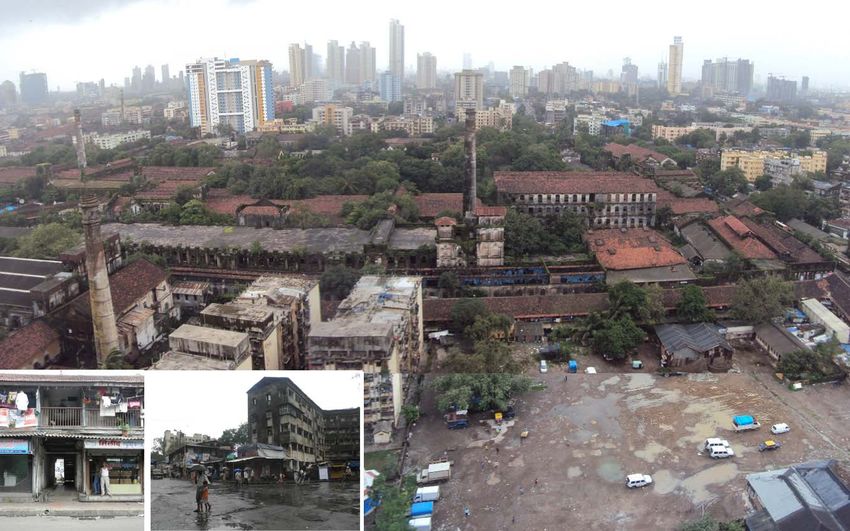
13. SITE ANALYSIS .................................................................................................44
14. PRECEDENTS ………………………………………………………………….51
Redevelopment of Highline Park, New York ............................................51
Massachusetts Museum of Contemporary Art...........................................53
vi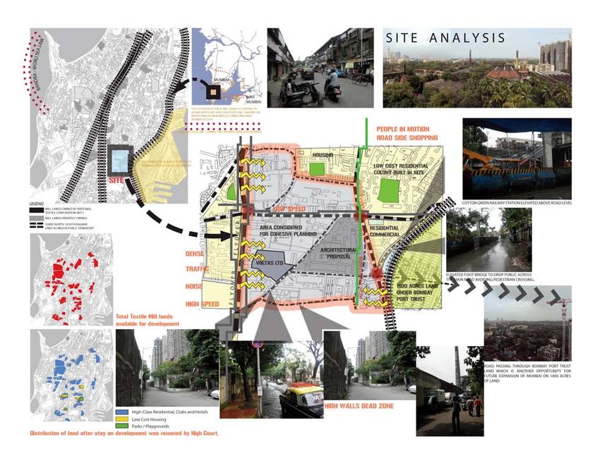
15.        DESIGN DEVELOPMENT ..................................................................................55

APPENDIX

APPENDIX: DEVELOPMENT CONTROL REGULATIONS (DCR) FOR MILL
LANDS..............................................................................................................................66

BIBLIOGRAPHY ..............................................................................................................74

                                                                vii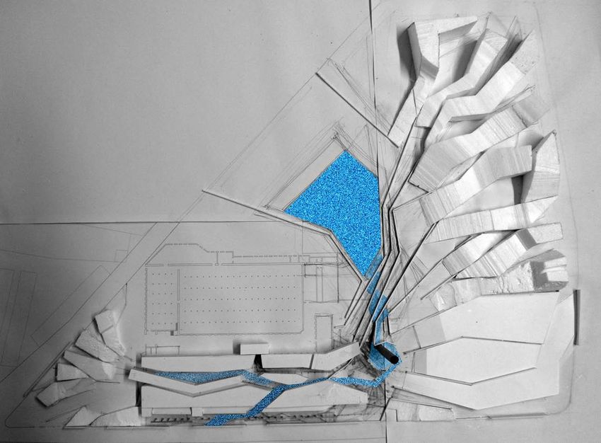
LIST OF TABLES

Table                                                                                                          Page

1. Declining status of Manufacturing in Mumbai (1980 – 1998) ....................................31

2. Declining status of Manufacturing compared with other employment sectors
      in Mumbai (1980 – 1998) ......................................................................................32

3. SWOT analysis of five different Mill sites in Mumbai ...............................................47

4. Distribution of land use of Mill land redevelopment as per size of plot .....................67

                                                        viii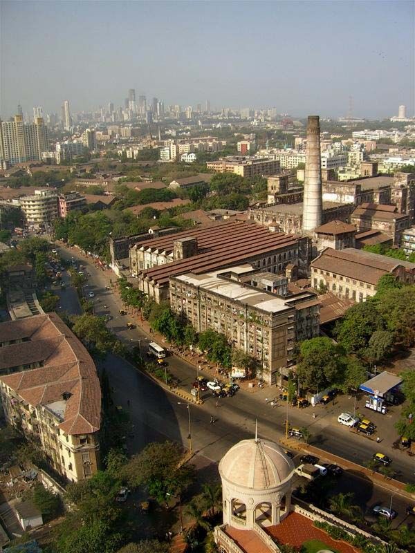
LIST OF FIGURES

Figure                                                                                                                        Page

1. Aerial view of the city....................................................................................................2

2. City view ........................................................................................................................5

3. City map ........................................................................................................................6

4. Early map of Mumbai showing seven separate islands .................................................8

5. Land reclaimation and urban development of the city by the years ..............................8

6. Bombay islands in 1500 ...............................................................................................10

7. Bombay islands in 1661 ...............................................................................................10

8. South Bombay..............................................................................................................10

9. Bombay fire 1803 ........................................................................................................10

10. Amalgamation of seven islands ...................................................................................10

11. First Railway line 1853 ................................................................................................10

12. First textile mill owner Cowasji Jehangir ....................................................................11

13. City's Municipal Corporation ......................................................................................11

14. Bombay Port Trust .......................................................................................................11

15. City major land reclaimation ......................................................................................11

16. New Mumbai ...............................................................................................................12

17. Marine Drive ................................................................................................................12

18. India United Mill No.1 .................................................................................................12

19. Aerial view Parel, Mumbai ..........................................................................................12

20. Aerial view, Girangaon ................................................................................................12

21. Cuffe Parade.................................................................................................................14

22. Gateway of India ..........................................................................................................14

                                                                 ix
23. Bombay Streets ............................................................................................................14
24. Mumbai Downtown .....................................................................................................14
25.Gateway of India (Today) .............................................................................................14
26. Market Street (Today) ..................................................................................................14
27. Regal theatre (Old).......................................................................................................14
28. Churchgate station (Old) ..............................................................................................14
29. Victoria Terminus railway station ...............................................................................14
30. Regal theatre (Today) ..................................................................................................14
31. Churchgate station (Today)..........................................................................................14
32. Victoria Terminus railway station (Today)..................................................................14
33. Ganeh idol ....................................................................................................................16
34. Chowpaty beach ...........................................................................................................16
35.Street side food .............................................................................................................16
36. Siddhivinayak temple...................................................................................................17
37. Prince of Wales Museum .............................................................................................17
38. Shoe market .................................................................................................................17
39. Diagram Urban environmental issues ..........................................................................19
40. Girangaon map .............................................................................................................22
41. Map showing location of textile mills in the city ........................................................24
42. Road side grocery shop ................................................................................................25
43. Shops / Commercial at street level...............................................................................25
44. Road side flower shop..................................................................................................25
45. Mill workers housing ...................................................................................................26
46. Marathi theatre .............................................................................................................28
47. High Street Phoenix mall and Residential tower .........................................................39
x48. Ashok towers ...............................................................................................................40
49. Godrej Heights .............................................................................................................41
50. Division of land between three stake holders ..............................................................42
51. Location of Mill lands in Mumbai ...............................................................................44
52. Site analysis .................................................................................................................48
53. Architectural / Structural analysis of site .....................................................................49
54. Site Surroundings .........................................................................................................50
55. Elevated Highline park ................................................................................................51
56. Highline rail bridge ......................................................................................................52
57. Highline Park features..................................................................................................52
58. MASS MoCA ..............................................................................................................53
59. Light well at MASS MoCA .........................................................................................54
60. Gallery space................................................................................................................54
61. Museum Entrance ........................................................................................................54
62. Industrial building refurbished.....................................................................................54
63. Mill Chimney ...............................................................................................................55
64. Mill premise .................................................................................................................56
65. Mill premise .................................................................................................................56
66. Vibrant character of the city ........................................................................................56
67. Site response to context ...............................................................................................57
68. Existing Mill structure .................................................................................................58
69. New Fabric ...................................................................................................................58
70. Restless nature of site...................................................................................................58
71. Sketch showing city’s fabric merged with the mill fabric ...........................................58
72. Diagram showing forces within site ............................................................................59
xi73. Fifteen feet high Mill boundary wall ...........................................................................59
74. Mill interiors spaces reacting to site forces..................................................................59
75. Chimney as focal center ...............................................................................................60
76. Site responsive development........................................................................................60
77. Design development.....................................................................................................60
78. Study of light within existing Mill structure ................................................................60
79. Site Model ....................................................................................................................61
80. Fragmented Mill structure............................................................................................61
81. Composition - 1............................................................................................................62
82.Composition - 2.............................................................................................................63
83.Composition - 3.............................................................................................................64
84.Composition - 4.............................................................................................................65
xiiCHAPTER 1
STATEMENT OF INTENT
There is a basic difference of vision between a planner and an owner's approach to
the redevelopment of the cotton mill lands in Mumbai. A vision of a planner is to take a
holistic view on the issues related to the city. For a visionary planner, a “city” is referred
to as people, streets, transportation, vegetation, buildings and places and so its response
to the development is in reference to this landscape adding life to the city. It is my
intention to explore the transition of this development by layering the mill fabric with the
new urban development in the city. I would like to take a holistic view of the available
land and look it as an asset meant to be put to the fullest benefit for the city and further
represent the interest of the owner, state and the workers. I intend to merge small group
of mill lands together and prepare a development plan for a single group of mill lands.
The building and infrastructure of old cities have value, in that they reveal the
history through their physical forms. The existence of the old with the new, where both
hold importance in the service they provide is what generates the genius loci of these
cities. It is only the physical presence of these structures that conveys the history of the
growth of the city, and imparts the spirit of the city. To completely wipe them off the
fabric of the city would be like blanking off completely an important era of the history 1.
The fabric, though functionally obsolete, represents an important era in the development
of this metropolis. Here is an opportunity to preserve old mill Architecture and create low
cost housing, playgrounds, cafeterias, green promenades along with new office spaces to
bring new business to the city that drives the economy of the country.
1The present economic forces make it difficult for the mills to continue running
within the city. The fact that the textile mills that are located on, now is a very highly
priced inner city property makes it subject to a number of economic and political forces.
Also the changing technology, including the use of machines with high speeds is
incompatible with the existing buildings making them functionally obsolete, as they
cannot withstand the vibrations. Also the large volumes and larger windows do not allow
the humidity to be controlled to meet the requirements of the new weaving technology.
However, these buildings are strong edifices, capable of serving many more years of life
if maintained well. They leave a legacy of space and structures which still stand.
Figure: 1 Aerial view of the city2
2The ongoing development is in favor of high rise residences, elite class clubs and
hotels without paying attention to the city’s issues. The question arises: who has the first
claim to such lands. Is it the mill owner, who have been given countless concessions by
the government to run their industries and who had surrendered their mills to government
when they were unable to run? Or the workers / public, where up to 40% of people do not
even have roof over its head? Or the public at large, who are reeling under acute shortage
of open space, one of the lowest in the world.3
Along with preserving these buildings, it is my opinion to create public open
spaces in different mill plots and merge new functions giving public access to the premise
which was restricted in the past and now even after it is abandoned. The current open
space requirement to population in the city is alarming and as low as 0.04 acre per
population of 1000 as compared to 5.3 acres in New York, 4.84 acres in London and 4.4
acres in New Delhi.4 Also taking owners interest into consideration, surrounding site
conditions and generating employment opportunities, I would like to convert some of the
existing mill structures into new workplaces for small scale business and propose new
office complex which emerged from the current landscape, creating an urban mill fabric.
Here is the challenge to have public spaces along with private work spaces having shared
common amenities. Because of the high value of real estate and as per Charles Correa's
report5, the available Floor Space Index used in public parks and public buildings should
be used in the same plot commercially. Here is another opportunity to use the excess
Floor Space Index to generate more jobs in the city.
3Notes
1
http://www.intbau.org/archive/Mumbai.htm
2
http://img267.imageshack.us/img267/2120/45797143295037522aco6aazo0.jpg
3
http://urbanplanningblog.com/507/revitalizing-mumbai-%E2%80%93-the-mill-land-
issue/
4
http://docs.google.com/viewer?a=v&q=cache:VuuAjY06eGgJ:www.bcpt.org.in/
webadmin/publications/pubimages/openspaces.pdf+open+space+requirement+to+
population+in+the+city+of+mumbai&hl=en&gl=us&pid=bl&srcid=ADGEESiQ_
4MFhmmIpsLeBrUXxD0pbSRIEguLE36YA_nE51jpDmbe78Edg2xVuGisBYX_
98yMjN6MW_bsTrzrCFKQhzpWBk0OYF3HjfXHbwLiVHqf2x1SFij257n0LAg
FUSb8ZhGUDe4&sig=AHIEtbQK7hQDDfjxPqEYnJ6DYqsWWCxIxA
5
Chapter – 11
4CHAPTER 2
MUMBAI - GEOGRAPHY
Figure: 2 City View1
India’s first and world’s sixth biggest metropolitan area, capital of Maharashtra
state, commercial, financial & entertainment capital of the country, home to over 21
million people, density of 25000 people per square kilometers , Mumbai is the most
populous city in India & second most populous city in the world. It connotes more than
just the land area and material wealth. It is not just a city but it’s a concept, a dream
cherished my millions of citizens.
In the past Mumbai was considered as the most important port & a gateway to the
west because of its geographical position. Located on the western coast of Maharashtra,
5Mumbai spans a total area of 603 sq. km (233 sq. mi) with a total coastal length of 180
km. (112 mi) Mumbai is bounded by Arabian Sea to the west. All parts of the city are
efficiently connected by Mumbai’s mass transit system consisting of trains and buses.
Predominantly organic in its urban form, the city consists of 10% vehicular road
coverage.
Figure: 3 City Map (Author)
Northern region of the city consists a National park (S. Gandhi National park) that
extends over 40 square miles, making it 1/6th the size of the city. . Mumbai’s three major
lakes (Tulsi, Vihar & Powai) are located within this forested area. The coastline of the
city is indented with numerous creeks and bays. The eastern waterfront is covered with
large mangrove swamps whereas the west coast is sandy and rocky. The city lies in the
6tropical climate zone resulting in harsh monsoons & hot summers. With an average
annual temperature of about 80F, Mumbai receives a lash of rainfall equaling to an
average of 96 inches per year.
City’s downtown is located to the south & it is popularly known as South Mumbai
or the Island City. Because of its tapering peninsular form, urbanization of the city
continued towards the north. This region today is considered as Suburban Mumbai.
Whereas towns like Thane, New Mumbai & Panvel serve as Mumbai’s satellite towns.
Both the districts (south & suburban) are administered by city’s municipal council known
as BMC - Brinhanmumbai Municipal Corporation. Mumbai is divided into 17 wards for
the purpose of civic administration.
Notes
1
http://www.worldnavigator.info/data/gallery/00000018/Aerial_photo_of_Mumbai_city.j
pg
7CHAPTER 3
MUMBAI - COLONIAL
Figure: 4 - Early map of Mumbai showing seven separate islands. (Author)
Mumbai initially known as ‘Bombay’ was originally an archipelago of seven islands –
Colaba, Malabar Hill, Worli, Mazgaon, Parel, Mahim & Sion. These islands were
inhabited by farmers and fisherman and the land was extensively covered with forests. By
late 15th century, after quite a few invasions and rulers, the Portuguese took over the
islands and ruled without opposition for over a century.
Figure: 5 - Land reclamation & urban development of the city over the years. (Author)
8In 1661, the islands were handed over to England as part of a dowry arrangement.
In 1838, under the British rule, Bombay islands were amalgamated into a singular mass.
Since then the city has been constantly transformed by land reclamation projects. The city
is built on a foundation of continuously altered and reclaimed natural and urban
landscapes.
Colonial Mumbai was developed as a planned segregation promoted by English
ideology. The southern tip of the island city was fortified to create an insulated territory
for the colonial rulers. The northern part within the fortification included the elite
Indians, Parsis, Bohras and Hindu industrialists or traders. Small native traders, white-
collar workers and the working class lived outside the Fort walls in largely congested
areas further segregated on class and regional identities. At first the urbanization of the
island only occurred within the Fort area until a massive fire in 1803 provided an impetus
for urban improvements and land dispersal that led to expansion of the fortified town.
By 1850 Bombay had become the major colonial mercantile and industrial city
and cotton textile mills as foundation of its economy. Subsequently many of the great
monuments and public buildings in the island city were built with the wealth generated
by the textile industry. Land reclamation continued, closing the creeks & creating newer
destinations towards the north. With new developments in place and increased
employment opportunities, Bombay attracted millions of migrants around the state and
country. Soon Mumbai became the fastest growing metropolis with maximum capital
accumulation and the most unequal distribution of land. A trading town in its past,
Mumbai, today is an aspiring global city where space is a rare commodity created &
recreated by land reclamation & rehabilitation.
9CHAPTER 4
MUMBAI - TIMELINE
1011
12
Notes
1
 http://upload.wikimedia.org/wikipedia/commons/a/a6/Colaba_Causeway_construction%
2C_view_from_Colaba_island%2C_1826.jpg

2
 http://upload.wikimedia.org/wikipedia/commons/4/43/Ships_in_Bombay_Harbour%2C_
1731.jpg

3
 http://upload.wikimedia.org/wikipedia/commons/0/05/Malabarpoint_governmenthouse_
bombay.jpg

4
 http://upload.wikimedia.org/wikipedia/commons/4/48/A_View_of_Bombay_from_Mala
bar_Point_during_the_Fire_of_1803.jpg

5
    http://upload.wikimedia.org/wikipedia/commons/6/69/IslandsofBombay1893.jpg
6
    http://commons.wikimedia.org/wiki/File:Bombay_Thane_train_1853.jpg

7
 http://commons.wikimedia.org/wiki/File:Sir_Cowasji_Jehangir_Readymoney_(1
812-1878).jpg
8
    http://commons.wikimedia.org/wiki/File:Bombay_Municipal_Corporation.JPG

9
    http://upload.wikimedia.org/wikipedia/commons/f/fa/Kotia-1909.jpg

10
     http://commons.wikimedia.org/wiki/File:BombayReclamation_1911.jpg

11
     http://commons.wikimedia.org/wiki/File:Navi_Mumbai.jpg

12
     http://commons.wikimedia.org/wiki/File:Marine_Drive.JPG

13
     http://commons.wikimedia.org/wiki/File:India_United_Mill_1.jpg

14
     http://commons.wikimedia.org/wiki/File:Mill_lands_parel_ground.jpg

                                            13
CHAPTER 5
MUMBAI – THEN AND TODAY
Figure 211: Cuffe Parade, Figure 222 : Gateway of India, Figure 233: Bombay Streets
Figure: 244: Mumbai Downtown, Figure 255: Gateway of India (Today),
266 –Market Street (Today)
Figure277: Regal Theatre (Old), Figure288: Churchgate station (Old), Figure 299: Victoria
Terminus Railway Station
Figure 3010: Regal Theatre (Today), Figure 3111: Churchgate station (Today),
Figure 3212 : Victoria Terminus Railway Station (Today)
14Notes
1
http://upload.wikimedia.org/wikipedia/commons/c/ce/Cuffe_Parade_old_.jpg
2
http://commons.wikimedia.org/wiki/File:Gateway_of_India,_Bombay._1911.JPG
3
http://commons.wikimedia.org/wiki/File:BombayKalbadevieRoad1890.jpg
4
http://commons.wikimedia.org/wiki/File:Mumbai_Downtown.jpg
5
http://commons.wikimedia.org/wiki/File:Mumbai_(Bombay)_Gateway_of_India.
JPG
6
http://commons.wikimedia.org/wiki/File:Mumbai-centre-street-market.jpg
7
http://upload.wikimedia.org/wikipedia/commons/a/a9/Regal-Cinema-1935.jpg
8
http://commons.wikimedia.org/wiki/File:Churchgate_station.jpg
9
http://commons.wikimedia.org/wiki/File:V.M._Doroshevich-East_and_War-
British_India._Railroad_Station_in_Bombay_enhaced.jpg
10
http://commons.wikimedia.org/wiki/File:Regal_Cinema,_Colaba,_Mumbai.jpg
11
http://upload.wikimedia.org/wikipedia/en/b/b1/Mumbai_Churchgate.jpg
12
http://commons.wikimedia.org/wiki/File:Chhatrapati_Shivaji_Terminus_(The_
Victoria_Terminus),_Mumbai_-_India.jpg
15CHAPTER 6
MUMBAI – URBAN
When it comes to urban development, Mumbai is considered as an organic city
that was built, transformed and developed by a number of reclamation projects and
temporary policies. The city is entirely a mixed use settlement where place of residence,
place of work, public places, transportation, retail shops, industries, commercial,
educational districts etc. exist together. This is perhaps the most important reason for its
vibrant character.
Incepted in 1853, Mumbai’s local train system consists of three transit lines
running south-north and effectively connecting almost all the corners of the city. Mumbai
as compared to any city in India has the maximum proportion of people who use public
transport or walk to work which are fundamental components of any good city. With its
mass transit system running almost 20 hours a day & 7 days a week, Mumbai city never
really sleeps. It celebrates festivals of all the religions, almost monthly, with same
enthusiasm and energy. Mumbai’s hot & humid climate is one of the reasons for its
constant active nature. Corner side plazas, public places and beaches are always occupied
by citizens of all kinds all year around.
Figure 331: Ganesh Idol, Figure 342: Chowpaty beach, Figure 353: Street side food
Hawkers, vendors, street side food stalls and most importantly, people are never
rare in this city. It works well and inspires its citizens to work productively because of the
16way it is built. A true metropolis and the city of the migrants, Mumbai is one of the most
livable cities in the country. The growing population of this metropolis proves the same.
Mumbai’s built environment does not lack variety either. From the southern tip of
the city to its northern border, it encompasses array of spaces, buildings and destinations
representing its growth from colonial era to present day metropolis. Most of the
monumental buildings in the city were built during the British regime. These structures
still serve as important public, infrastructure and administrative buildings of the city. The
built environment throughout Mumbai is composed of various architectural styles – from
Indo-Saracenic to Hindu, from Greek revival to modern.
The urban characteristic of Mumbai could be studied by looking at the different
spatial elements that are woven into its urban fabric. Locations ranging from important
public places to historic districts or a lively street to a popular market place, fuel the city
for its everyday hustle-bustle and its very existence. Following pages describe some of
the places that define this city.
Figure 364: Siddhivinayak temple, Figure 375: Prince of Wales Museum, Figure 386:
Shoe Market
17Notes
1
http://upload.wikimedia.org/wikipedia/commons/e/e9/Ganesh_Idol_in_Mumbai.jpg
2
http://commons.wikimedia.org/wiki/File:Vendors_on_Chowpatty_Beach.jpg
3
http://commons.wikimedia.org/wiki/File:Bademiya_restaurant,_Mumbai.jpg
4
http://commons.wikimedia.org/wiki/File:Siddhivinayak_temple.jpg
5
http://commons.wikimedia.org/wiki/File:Prince_of_Wales_Museum,_Mumbai.jpg
6
http://commons.wikimedia.org/wiki/File:Bandra_Shoe_Market.jpg
18CHAPTER 7
MUMBAI – URBAN ENVIRONMENTAL ISSUES
Mangrove Destruction: Mangroves are an integral part of the landscape of
Mumbai. The city was originally
surrounded by 5000 acres of
mangrove swamps. Among these,
the city has lost almost 40% to
reclamation of land for construction
and development projects. As a
result, Mumbai became more
vulnerable to natural disasters.
Land Use Changes: Salt
Pan Lands: Similar to its mangrove
cover, the city has a chunk of land
dedicated to salt production.
However, the lack of land for
residential accommodation has pushed the developers to convert the salt pan lands into
residential and commercial zones. Salt pan lands are an important barrier between land &
sea. And with their land use change, the danger of flooding has increased.
Land Use Changes: Mill Lands: Central district of Mumbai consists of 600
acres of defunct mill lands that represent the textile era of the city. These mill lands are a
boon for Mumbai if developed in the right way. However city developers are using these
19lands for residential and commercial unsustainable constructions. This is further adding
to the already inflated problems of the city.
Forest Depletion: Urban development didn’t spare Mumbai’s only breathing lung
too. Illegal construction continues to develop on National Park periphery. Consequently
this rich and unique forest which acts as an essential green cover and carbon sink is
shrinking day by day.
Rapid land reclamation: Mumbai once had numerous creeks flowing into the
island. But as urbanization of the city continued, these water bodies got filled up. Such
excessive coastal land reclamation is unhealthy for an island city like Mumbai.
Pollution, population and lack of space are traditionally described as the ultimate
problems of Mumbai. These issues consequently lead to environmental degradation of
this global city. Leopard attacks in a bustling city, landslides, abnormally high
temperatures in summers, erratic rainfall have long since warned the city of the
impending doom. It is believed that the environmental problems of Mumbai have
emerged due to the creation of the city itself.
With change in climate and global temperature rise, Mumbai now receives
extravagant monsoon showers making city’s drainage system inadequate. On 26th
November 2005, Mumbai was lashed with 39 inches of rainfall within 24 hours. This day
was an eye opener when the city came to a standstill. Disasters like 26/7 not only cause a
distress among the citizens but they also drain the city economically. Mumbai’s urban
environmental issues might not have a water tight solution at the moment. But it’s
important that they are studied, analyzed & addressed in the best possible way.
20Over the last few years Mumbai has witnessed several signs of ‘sanity’ in terms of
environmental protection. Some of the leading organizations in the city along with active
environmentalists are persistently fighting for city’s sustainability. Their efforts are
essential & could turn out to be one of the most crucial steps towards Mumbai’s
environmentally healthy future.
Mumbai is still in the need of similar efforts. Considerable damage has already
been done to the 600 acres of land belonging to the textile era of the city. Yet there exists
a small ray of hope for Mumbai since some of the major chunks of derelict mills indicate
a strong potential for a sustainable development.
21CHAPTER 8
GIRANGAON – THE MILL PRECINCT
Location
“Girangaon” is a Marathi word for “Mill village” or the mill precinct, which is
characterized by industrial architecture of more than 50 mills. Over 600 acres of land in
this region was dedicated to textile industry in early19th century.
Girangaon was home to thousands
of mill workers and their families. The
unique housing settlements by workers,
their social networks and communities
dominated Mumbai’s mill precinct for
decades.
Diagram to the left highlights
Girangaon on the map of Mumbai. The
precinct stretches from Lalbaug to Parel
and Worli to Sewri and spreads across an
area of 25sq.km. The entire mill precinct is
efficiently integrated into Mumbai’s mass
transit system and well connected to major
Figure 40: Girangaon map (Author) streets in the city.
Origin
The inception of textile industry in Mumbai goes back to late 19th century when
the first mill was established by Cowasji Davar in the year of 1856 with the help of 50
22leading businessmen in the city. By 1862, four mills were added and this number grew to
21 by 1885.
By early 20th century there were more than 50 textile mills in Mumbai which
transformed it from a trading town to a manufacturing center. Increased employment
opportunities in mills drew thousands of migrants from towns and villages all over the
state. By 1931 half of the city’s population was economically dependent on textile
industry.
Development
Residential, institutional and infrastructure development had already commenced
in the south region of the city and development plans were now being modified and
extended towards the north. To encourage the development of textile industry and
promote industrial production, acres of lands in Central Mumbai were given to the mill
owners at concessional rates by the colonial Bombay Government. Mumbai’s
development as an economic hub was greatly enhanced by these very mills.1
Areas where mills were located grew to become the heart of the city. Eventually
central Mumbai witnessed a distinctive skyline of tall chimneys and gigantic mill
structures.
Characteristics
Over 50 mills in less than a 3 mile radius converted this portion of the city into an
incredibly crowded, lively and dynamic hub. Almost all of the workers employed by
mills lived in close proximity of their place of work. Such an aggregation of workers
within a smaller region of the city increased the social and cultural involvement of the
23workers in the community. This led to stronger community ties and a rich network of
physical and social infrastructure.2
Figure 41: Map showing location of textile mills in the city3
The map above shows the locations of 58 mills in Girangaon that establish a
unique urban fabric of this region. Mill workers housing, recreational grounds (for
worker colonies), places of worship and entertainment are some of the dominant elements
in the urban characteristics of Girangaon.
24Social Structure
In the period of 1891 to 1921 the population of Parel & Byculla doubled where as
the population of Worli & Sewri increased by five times. Mumbai now received migrants
from not just east and coastal Maharashtra, but it was also populated by crowds from
Uttar Pradesh and Gujarat (some of the other states of India) all employed in textile
industry. Mill workers included people from all castes and religion. Soon they established
their distinctive places of worship such as temples and mosques and started side
businesses in meat and vegetable markets.
Initially in the migrant population, the men arrived alone in order to find
employment. Later as they settled they brought their families along. In 1875 when the
textile industry was at its peak the housewives of workers too, started working in the
mills for additional income. However the male population among the workers community
always dominated the female population.
Figure 424: Roadside grocery shop, Figure 435 : Shops/Commercial at street level,
Figure 446 : Road-side flower shop
Most of the single men lived in groups. As a result a number of housewives
started buffet services and canteens for lunch and dinner. In 1970’s, the mill precinct had
over 500 canteens predominantly serviced by the female group. Along with these, most
of the residential buildings incorporated side businesses of workers such as retail,
25grocery, newspaper, flower, sweets shops, snack centers, ice-cream parlors, pharmacy,
service shops like laundry shop, domestic flour mills etc. on street level.
Housing
Due to housing demands from the mill workers, the Bombay Development
District (BDD) and Bombay Improvement Trust (BIT) built rows of low cost houses in
Girangaon. These 1-2 stories high, single to double room tenements with a common nar-
row corridor, and a block of shared toilets situated at the end of the corridor came to be
known as “Chawls”.
Figure 45: Mill workers housing (Author)
26A group of 3 to 4 Chawls were built around a central courtyard that became the
venue for family celebrations, weddings, sports, festivals, community fairs and meetings.
This congested tenement living created a “Chawls Culture” based upon a unique, shared
lifestyle and collective identity. Since the dwelling units in Chawls were very small in
area, (Hardly 200sq.ft) most of the residents spent their days in the common corridors and
staircases. Small grounds, sidewalks, spaces between the two Chawls, benches under
trees, boundary edges, shop fronts and street corners also known as “Chowk” or “Naka”
became the social gathering spaces. Mill lands were designed in such a way that they will
have sufficient amount of open space around them, so that the nuisance to surrounding
community is limited. Hence these lands efficiently merged into the surrounding urban
fabric as opposed to standing exclusive. In addition to ‘workplace’, mills became a
second hometown for mill workers. They included a place of worship, family clinics and
canteens.
Culture
Many of the social groups in a single Chawl shared a common hometown.
Sometimes they belonged to the same extended family, had common interests and
cultural outlooks. Girangaon was dense, poor & illiterate. Yet it was filled with talent in
theatre, music and arts. The mill precinct gave many talented and versatile artists to city.
People here enthusiastically celebrated different Indian festivals throughout the year.
During the festive season the streets and Chawls of Girangaon looked no less majestic
than a wealthy south Mumbai neighborhood7. In fact the hard work, simplicity, honesty
and benevolence of people added to the attractiveness of this precinct. Even today, the
27festivals are enjoyed with same exuberance and honor; however the workers’ society is
poorer, hurt and unhappy.
Figure 46: Marathi theatre8
The mill workers also staged brilliant theater and sustained folk arts like Lawani,
Tamasha, Bhajan, Namaan, and Shahiri Powadas. All these art forms narrated the stories
of their life style, their social and political upheavals, the freedom struggle of the country
and Samyukt Maharashtra Andolan.
Girangaon or the mill precinct of Mumbai has experienced a great amount of
upheaval over the past two decades. Textile industry in Girangaon - the backbone of
city’s economy gradually set out to disintegrate under pressures from various other
sectors. Hence the decline of Mumbai mill lands is rooted in several economic, social and
political issues9.
Even after their decline in Mumbai, the textile industry remains India’s second
largest employer after agriculture. It accounts for a fifth of industrial production and
employs 18 million directly. If one adds all those engaged in related industries, like
textile machinery, dyes and chemicals, marketing, transport - not counting the millions of
farmers growing cotton - the number dependent on it goes up substantially. Moreover, it
28contributes over 30 per cent of all export earnings. Export of Indian textiles comprise of
2.4% of the world trade.10
Mumbai Mills contributed significantly towards the creation of country’s finest
cloth. After led by the textile mills, several other large and medium scale industries were
established in the post-independence era and the development plans made provision for
the same through earmarking industrial zones for manufacturing, trade and logistics
operations. Mumbai has shown how to build the enormous potential in industrial
production and almost became one of the country’s backbones of industries and
economy11.
Notes
1
(Nallathiga 2010)
2
(Mhatre, Downtown revitalization: Lessons for Mumbai Mill lands 2006)
3
http://img464.imageshack.us/img464/800/mumbaimilllandsresized2cq.jpg
4
http://commons.wikimedia.org/wiki/File:Dried_produce_shop,_Crawford_marke
t,_Mumbai.jpg
5
http://commons.wikimedia.org/wiki/File:P1010628-EEEEE.jpg
6
http://commons.wikimedia.org/wiki/File:Flowers_at_Matunga.jpg
7
(Adarkar, Mumbai's Industrial landscape 2006, 84, 85)
8
http://commons.wikimedia.org/wiki/File:Kaka_tells_story.jpg
9
(Mhatre 2005)
10
(Ripping the fabric 2002)
11
(Nallathiga 2010)
29CHAPTER 9
DECLINE OF THE TEXTILE MILLS
In mid-nineteenth century, textile industry experienced several technological
changes all over the world. The conventional handloom technology faced a severe
competition from the advanced power loom techniques. The mill owners did not update
the machinery in the Mumbai Mills to keep up with the changing trends and the low-
skilled workers were also comfortable with this policy. During the same period the fuel
prices and costs of raw material increased. Reservation policies and adverse taxation
discouraged the mill owners from investing more in the industry. By 1980’s it became
uneconomical to maintain large scale industrial units within the city limits on account of
high power and tax costs.1 Also, the economic and technological change struck major
mill towns like Manchester in UK and Lowell in Boston and eventually there was an
overall slump in the world textile market. By 1990’s the employment rates of service
industries increased by large numbers.
Another reason for the ultimate shut down of mills is the 18 month long strike by
mill workers’ union in 1982. Nearly 250,000 workers & more than 50 textile mills went
on strike. Rashtriya Mill Majdoor Sangh (RMMS) the largest workers union in the city
led by Congress (political party) fought the government and mill owners for their rights.
The Bombay Industrial Relations Act, 1946 (BIR Act) sought to establish a single union,
the Congress-led RMMS as the only approved union. This move was taken primarily to
renounce the option of strikes and focus on other means of resolution. The strike of 1982
was called for primarily to strike down the BIR Act along with increase in wages.
30The strike did no good for the workers instead it opened a new strategy for mill
owners. During the strike, mill owners outsourced the work to workers in Bhiwandi, a
distant suburb who were paid almost 50 percent of the wages in spite of longer working
hours and no legal compensation.2
All this led to huge losses and the running of the Cotton Textile Mills became
unviable. Several mills were declared sick and a few even shut down their operations.
Only a few managed to survive. There were 58 cotton textile mills in Mumbai. Of these,
26 were deemed ‘sick’ and, therefore, taken over by the Government of India. The
remaining 32 mills continued in the private sector.
Declining status of Manufacturing in Mumbai (1980 - 1998)
No of Workers
Mill locations
1980 1990 1998
Mazgaon 16456 6925 4968
Tarawadi 28114 18933 12800
Byculla 27257 30332 13134
Parel 34879 15073 10561
Sewri 15960 18163 8425
Naigaon 21591 12485 13595
Prabhadevi 29721 21032 20225
Worli 61691 30895 21494
Chinchpokhli 50787 22083 18220
Table 1: Declining status of Manufacturing in Mumbai (1980 – 1998)
31% of workers in major Variation in absolute no of
Employment sectors activity groups workers
1980 1990 1998 1980 1990 1998
Agriculture and allied 1.04 0.43 0.26 23081 1049 6077
Mining and Quarrying 0.04 0.01 0.01 920 348 182
Manufacturing 36.73 28.47 17.73 817718 633826 394772
Construction 0.63 0.83 0.61 14028 20082 18002
Trade, Restaurants & Hotel 24.51 28.03 29.07 545591 705127 747723
Transport & 9.43 5.42 9.97 209883 131472 263504
Communication
Finance, Insurance, Real 6.24 10.25 13.69 138849 248541 361888
Estate & Business services
Community, social and 13.64 23.87 28.52 303557 578945 753648
Personnel services
Other 7.10 1.21 0.37 157996 29257 9833
Total 100.0 100.0 100.0 2226011 2425881 2642577
Table 2: Declining status of Manufacturing compared with other employment sectors in
Mumbai (1980 – 1998)
Notes
1
(Nallathiga 2010)
2
(D. D. Monte 2002, 78 - 85)
32CHAPTER 10
REDEVELOPMENT OF TEXTILE MILL LANDS
Redevelopment of mill lands in Girangaon is one of the few options left for a
sustainable revival of the city. Mumbai’s ecological, social & cultural aspects are the
fundamental drivers in this process of urban revitalization.
When textile mills were fully operational, they were excluded from reservations
for public amenities. According to an ex-government planner, there was no reason to
believe they would shut down and hence these lands were regarded as industrial zones
alone. But a few years later, with technological changes and economic restrictions many
of the mills were declared ‘sick’ and it was hard for mill owners to pay thousands of
workers unless they were allowed to sell their assets. As a result, in 1990, DCR 58
(Development Control Regulation) came into existence. DCR 58 allowed the mill owners
to sell part of their land. For the first time Mill owners were allowed “change of user”
from Industrial to Residential / commercial on the condition that they use the resultant
funds for the revival of the mills. They were allowed to sell only 15 percent of the mill
land and use the resources to modernize the mills.
In 1991, five to six mills were developed on the basis of DCR 58, but not a single
mill undertook any kind of modernization. The skyline of Girangaon began to change
steadily with the arrival of high rise luxury towers. When Phoenix converted one of its
structures into Bowling alley (the permission for this was obtained on the pretext of
building a recreation center for the workers), Girangaon was really shaken. The issue of
mill lands no longer was limited to mill workers alone: it concerned the issue of urban
development.
33Please note that the objective of DCR 58 was not supposed to be real estate
development, it was meant to protect the jobs of the workers, by allowing only a partial
sale. If the development of mill lands was the main objective, then the government should
have worked on comprehensive development plan to include all mill lands, in fact the
entire Girangaon. It should have been addressed as an urban planning issue instead. The
actual outcome as can be seen by all is a piecemeal, ad hoc and often surreptitious
exploitation of real estate for immediate gains.
Under the banner of GKSS (Girni kamgar sangarsh samiti) Mill Workers Action
Committee, a protest march was organized by the workers along with artists, activists and
local residences against government. All of them spoke against the new real estate
developments in which, needs of the neighborhood were totally neglected.1
Notes
1
(D. D. Monte 2006, 94 - 107)
34CHAPTER 11
CHARLES CORREA STUDY GROUP REPORT (1996)
Holistic approach1
The current piecemeal and individual development of mill lands is one of the
major problems when it comes to retaining the character of Girangaon. This approach
initiated by the intransigent mill owners denies the integrated development the city needs.
It also points out the lack of any overall planning and development strategy seeking to
create coherent urban form and address other issues like housing for low income groups,
civic amenities and new employment opportunities for ex-mill workers.
Girangaon needs a comprehensive urban renewal plan that will take care of mill
sites as well as the surrounding communities. Since these lands are in close vicinity to
each other, each could be developed differently in accordance with its location, size and
neighboring uses and yet is a part of an integrated master plan for the entire mill district.
A complete system of urban network could be established by introducing new
destinations for entertainment, public, retail & commercial activities, transit and
recreational purposes. Consequently the Government of Maharashtra set up a study group
to prepare an integrated development plan for textile mills in Girangaon.
The study group chaired by architect & urban planner Mr. Charles Correa created
a design solution for a comprehensive redevelopment of textile mills in Girangaon. It
appointed teams of architects, engineers & conservationists to visit the 58 mills and
appraise & document the various structures and other prominent features in each of them.
However the group was denied access to 32 mills in private sector. 3 of those mills were
already keen to sell some of their land right away. Hence the report deals with remaining
35You can also read