RISK ANALYSIS NATURAL RESOURCE MANAGEMENT & - CGIAR
←
→
Page content transcription
If your browser does not render page correctly, please read the page content below
PrICE `60
oCT. 16-31, 2018, VoL. 18, ISSuE 8, No. 119                       A De v e l op m e n t A n D e n v i ron m e n t f ort n ig h t ly
                                              GEoGrAPHy and you

                                                                                    THE GIS SPECIAL
                                                                                       NATURAL
                                                                                       RESOURCE
                                                                                       MANAGEMENT &
                                                                                       RISK ANALYSIS
                                                                        ▀ g-Governance in India ▀ GIS and Higher Education ▀ GIS
                                                                        and River Floods ▀ New Techniques to Avoid a Kerala like
                                                                        Disaster ▀ Soil Erosion Risk and GIS Techniques
G’nY SINCE 2001
GEoGraphYaNdYou.Com
GeoGraphy and you a dEvElopmENt aNd
ENvIroNmENt fortNIGhtlY
VOL. 18 ISSUE 8 No. 119 OCTOBER 16-31, 2018
With the help of GIS we can build models highlighting the flood-susceptible areas. These models will
further aid in the creation of flood prediction and early warning systems.
GIS & reSource GIS & DISASTerS
GIS and Remote Sensing in Natural Resource New Techniques to Avoid a Kerala like Disaster
Management Giriraj Amarnath
Pushpanjali, Josily Samuel & Visha Kumari India should step forward to implement measures for flood risk mitigation.
GIS and remote sensing serve as a platform to generate information and Several natural and man-made ways can ensure the social well being.
make wise decisions for sustainable development of natural resources.
GIS and River Floods
Role of Geospatial Technology for Monitoring Natural S M Ramasamy
Resources Complex geological dynamics of the rivers leading to floods are understood
Neeti with the help of GIS technology.
Temporal monitoring of natural resources through GIS allows us to
understand the change in spatial patterns of different natural resources. Soil Erosion Risk and GIS Techniques
Atiqur Rahman and Asif
Human-Induced Land Transformations and GIS Various mathematical models are applied to GIS for studying the extent of
Subin K Jose and Madhu Gopal soil erosion and ground water depletion.
GIS can assess human induced land transformations in the forest eco-
system. It easily detects the extent and current rate of land degradation. Application of Remote Sensing and GIS with respect to
Disaster Management
g-Governance in India Saumitra Mukherjee
D Giribabu Predicting natural disasters in advance through GIS will help to efficiently
g-governance is required for the proper functioning and implementation of plan disaster management strategies.
geospatial technology in India.
cAreer
GIS and Higher Education
Staff Reporter In BrIef
Integrating a GIS curriculum with higher education is essential for creating a Letters; Editor’s note; GIS Updates; Term Power; Term Power
holistic approach towards various subject areas. Rating; Books & Websites
Expert Panel
B Meenakumari Ajit Tyagi Rasik Ravindra Saraswati Raju
Chairperson, Air Vice Marshal (Retd) Former Director, Former Professor, CSRD,
National Biodiversity Former DG, IMD, NCAOR, Jawaharlal Nehru
Authority, Chennai. New Delhi. Goa. University, New Delhi.
Prithvish Nag B Sengupta Sachidanand Sinha D Mukhopadhyay
Former Vice Chancellor, Former Member Secretary, Professor, CSRD, Managing Director
MG Kashi Vidyapeeth, Central Pollution Control Jawaharlal Nehru AIRA,
Varanasi. Board, New Delhi. University, New Delhi. New Delhi.
october 1-15, 2018 vol. 18 issue 7, no. 118: The article on public funding
of elections was quite informative. It highlighted the importance of
this key part of our democratic process, and what public funding of
GeoGraphy and you elections would entail, using examples from all around the world.
editor The equalising influence, as proposed by john rawls, when applied
SuLagNa CHaTTOPaDHyay to the visible lack of the same in the 2014 General elections, firmly
senior advisors puts the spotlight on the need for strict regulations and transparency
Rasik RavindRa in our election process. Please continue publishing such informative
saRaswati Raju
articles.—VenKaTeSh ShanKar via Email
leGal advisor
For more details log on to our website www.geographyandyou.com
KRISHNENDu DaTTa
research bY liGhts G’nY is a Good magazine and much liked from other domains may also be included
G’nY suPPort team by our students. It has very informative to make the magazine more interesting.—
aDITya SINgH, material that does not fail to satisfy their KaVIYaraSan r via Customer Feedback
KuNaL KHaNNa
KaNaV BHaRDwaj, curiosity.—LIbrarIan ST aLbanS
FaguNI PaNDIT, SchooL via Customer Feedback the maGazine does cover diversified topics
amIT KumaR,
ZaHID HuSSaIN related to recent trends and issues. but
i make sure that I thoroughly read articles I would request more articles based on
cover Photo
NIgHT LIgHTS IN INDIa aND published by G’nY. however, I would India’s rural environment and the factors
a gIS waTER-uSE maP suggest that to make the magazine more affecting it must also be covered in the
OVERLay
interesting only 50 per cent of its content upcoming issues.—abhIjeeT PaTIL via
corresPondence/
editorial office
must be theme based, while the rest can Customer Feedback
707, BHIKajI Cama BHawaN, cover other diversified areas.—Tarun
RK PuRam,
NEw DELHI - 110066 MaLhoTra via Customer Feedback mY exPerience with G’nY has been excellent.
PHONE: +91-11-46014233; I loved the issues ‘development driven
+91-11-26186350
FOR NEw SuBSCRIPTIONS, G’nY is a deliGhtful read and has a very easy disaster’ Vol. 18, issue no.117 and ‘Water
RENEwaLS, ENquIRIES to understand language. It covers all the ownership and accountability’ Vol. 18,
PLEaSE CONTaCT
CIRCuLaTION maNagER current issues which are really informative. issue no. 113. however, I would suggest
E-maIL: info@ but, I would like to read more about issues that it would be great if the articles provide
geographyandyou.com
PLEaSE VISIT OuR SITE aT related to recent trends in science and data charts and cover more environmental
www.geographyandyou.com technology, women and environment. issues.—rahuL raThore via Customer
FOR FuRTHER INFORmaTION.
—LabanI KuMar rohIdaS via Customer Feedback
©GeoGraPhY and You Feedback
aLL RIgHTS RESERVED
THROugHOuT THE wORLD. i have been a reGular reader of G’nY and
REPRODuCTION IN aNy althouGh i have no complaint about the it has helped me a lot to prepare for
maNNER, PaRT OR wHOLE, IS
PROHIBITED. content, but I find the quality of the print- competitive examinations. I really liked the
copy binding very poor. having said that, article ‘Genetically Modified Technology’ in
Printed, Published
and owned bY sulaGna I must mention that the ‘Water ownership the issue titled The agri-tech Perspectives,
chattoPadhYaY.
and accountability’ Vol. 18, issue no. 113 Vol. 17, issue no 102. The content in the
Printed at was simply great.—adarSh KuMar magazine much condensed covering a
INDIa gRaPHIC SySTEmS
PVT. LTD. F-23, OKHLa SInGh via Customer Feedback gamut of information in a lucid way.—
INDuSTRIaL aREa, PHaSE-1, PraVeen KuMar naIK via Customer Feedback
NEw DELHI - 110020.
i will have to say that G’nY publishes
Published from very informative content. In my opinion G’nY covers various new concepts. however,
IRIS PuBLICaTION PVT. LTD.
111/9 KISHaNgaRH, aRuNa more articles pertaining to recent trends in I request more information on cyclones and
aSaF aLI maRg, VaSaNT geomorphologic studies must be incorporated extreme rainfall events in the upcoming
KuNj, NEw DELHI-70.
in the magazine. also, not all the articles issues.—KaVaLPreeT SInGh via
gEOgRaPHy aND yOu should be theme based, some articles Customer Feedback
DOES NOT TaKE aNy
RESPONSIBILITy FOR
RETuRNINg uNSOLICITED
PuBLICaTION maTERIaL.
write Editorial Office: IPP Ltd, 707, Bhikaji Cama Bhawan, R K Puram, New Delhi - 110066. Letters may be edited for clarity and length.
aLL DISPuTES aRE SuBjECTED TO
Include name, address and telephone. Phone 011-46014233, 26186350 email editor@geographyandyou.com
THE ExCLuSIVE juRISDICTION OF
facebook http://goo.gl/eIeaH, linkedin http://in.linkedin.com/pub/geography-and-you/5a/b32/b24 website www.geographyandyou.com.
COmPETENT COuRTS aND FORumS
IN DELHI/NEw DELHI ONLy. subscriPtions For institutional subscriptions of print copies you may write to orders@geographyandyou.com
to contribute an article: Kindly send the abstract of your article in not more than 200 words to submissions@geographyandyou.com.
The abstract will be reviewed by our peers. Once selected we shall respond for the procurement of full article. The length of the final article
may range from 1000 to 1500 words. Please visit our website for publication and peer review policy.
The Editorial Advisor.
2 october 16 - 31 2018 GeoGraphy and you issue 8
GI S & DI S A S T ER S
Extreme rainfall events need not result
in debilitating floods. With proper
monitoring and forecasting disasters like
Kerala may be avoided.
4 October 16 - 31 2018 Geography and You issue 8
By Giriraj Amarnath
New techNiques
to Avoid A KerAlA liKe disAster
Kerala has witnessed one of the most devastating floods in 2018.
To reduce future occurrence and the impact of such disastrous floods, it is
imperative to focus on measures of greater resilience.
Photo CourtEsy: stEPhaniEmonot
GeOGraphy and yOu OctOber 16 - 31 2018 5
K
erala, with its magnificent natural Regulatory and Development Authority (IRDA)
landscapes and fertile valleys, is of India has instructed the insurance companies
often described as ‘God’s own to settle all claims expeditiously. Given the
country’. During June to August magnitude of the tragedy, there is considerable
2018, unusually heavy summer pressure on insurers to ensure immediate cash
monsoon rains dashed this idyllic image, causing flows. Health insurance companies could also
disastrous floods across the State. These were the take a hit due to an increase in waterborne diseases
worst floods the state has witnessed since 1924, resulting from the floods.
resulting in the death of more than 324 people
and requiring at least a million to be relocated responding to future disasters
(Babu, 2018). The districts suffering the severest In addition to examining and managing the
damage were Chengannur, Pandanad, Aranmula, immediate consequences of the Kerala floods,
Aluva, Chalakudy, Kuttanad and Pandalam. the obvious question to ask now is what can be
However, all 14 districts of Kerala were placed on done to cope more effectively with future water
red alert (Varghese, 2018, G R, 2018, BBC News, related disasters, thus reducing damage and loss of
2018, Mathrubhumi News, 2018). According life. Described below are ten measures that could
to the Kerala government, one-sixth of its total contribute to greater resilience, as such threats
population was directly affected by floods and become more frequent and severe.
related incidents (Press Trust of India, 2018). The improved flood forecasting: The first step is
Indian government declared this a level three to take advantage of recent improvements in
calamity, or ‘calamity of a severe nature’. flood forecasting. One critical limitation in India
In an unprecedented response to the heavy and other developing countries is the lack of
rainfall (Fig. 2), floodgates of 35 of Kerala’s 54 monitoring networks, which prevents near real-
dams were opened. At Idukki, for example, all five time flood prediction. In response, researchers
floodgates of the dam were opened simultaneously at International Water Management Institute
for the first time in 26 years. Heavy rains in (IWMI) and elsewhere are developing new
Wayanad and Idukki caused severe landslides and techniques that use increasingly available satellite
left the hilly districts isolated (Mathrubhumbi sensors to forecast floods based on river discharge.
News, 2018). Radar altimetry, for example, accurately estimates
water levels and river discharge—showing
crop damage much potential for places where there is no river
Continuous heavy rainfall in Kerala led to monitoring network (Tarpanelli et al, 2018). This
extensive flooding of agricultural lands, resulting technique is limited, however, by the low revisit
in crop losses with an estimated value equivalent time of the satellite, leading to delays in flood
to INR 150 to 200 billion (Shenoy, 2018). Coffee, prediction. To overcome this, researchers have
rubber, tea and black pepper were amongst the used the artificial neural network technique to
crops most affected. The extent of the damage to merge data from multiple sources, including
coffee, tea, cardamom, and rubber plantations is different satellite missions and optical sensors
not yet clear. In rural Kerala, many farmers may as well as radar altimetry. In a study, researchers
not be able to harvest at all this season. Also, many found this multi- mission approach to be the most
lack adequate access to insurance to aid their reliable tool for estimating river discharge (ibid).
recovery. better insurance products: Flood insurance for
crop damage and insurance pooling for extreme
insurers to take a big hit flood events is a must. IWMI and Consortium
Insurance claims resulting from the floods have of International Agricultural Research Centers’
been initially estimated at INR 5000 million. (CGIARs) Research Programme on Climate
The situation for insurance companies is not as Change, Agriculture and Food Security (CCAFS)
disastrous as the case of floods in Chennai or developed the index based flood insurance (IBFI)
Jammu and Kashmir where approximately INR for Bihar (Fig. 5) in collaboration with global
50,000 million and INR 20,000 million were reinsurer Swiss Re (Amarnath and Sikka, 2018).
paid, respectively (Sinha, 2018). The Insurance Scientists first examined past satellite images to
6 OctOber 16 - 31 2018 GeOGraphy and yOu issue 8
Fig. 1: Rainfall in India during August 13-20, 2018
Kerala witnessed
an average rainfall
of more than 300
mm in the month of
August, 2018.
Source: NASA
Fig. 2: Satellite images showing Kerala before flooding (left), i.e., on
February 6, 2018, and during flooding (right) on August 22, 2018
These are false-
colour images, in
which floodwaters
appear dark blue
and vegetation
bright green.
Source: US National Aeronautics and Space Administration (NASA)
Fig. 3: Rainfall pattern in Kerala during August 12-18, Fig. 4: Flooded areas detected using data from the
2018, which resulted in catastrophic floods JAXAALOS-2 PALSAR-2 satellite during August
9-14, 2018
Heavy rainfall
Kasaragod
resulted in
catastrophic floods
Kannur in Kerala, with Idukki Changanassery
Wayanad district receiving
more than 1,085 Mankombu
Kozhikode mm rainfall between Alleppey
August 12 and 18.
Malappuram
Palakkad Tiruvalla
Thrissur
Haripad Chengannur
Ernakulam Flood on 09 Aug. 2018 Flood on 14 Aug. 2018
Idukki Streams Road
Kottayam
Cities/Town
Alappuzha
Pattanamtitta
Rainfall (mm)
Kollam Following heavy rainfall in Kerala over almost all the
1085
0 districts were inundated. The initial map estimates the
Thiruvananthapuram overall flooding across these districts, based on data from
European Space Agency.
Source: India Meteorological Department, Pune Source: International Water Management Institute
GeOGraphy and yOu OctOber 16 - 31 2018 7
identify historic floods and prepare a flood risk forecasting will be of little help. To fundamentally
map. Villages in three locations were selected for reduce vulnerability in the face of future disasters,
the pilot; one in an area at high risk of flooding, government authorities need to delineate the 100
one in a place with a medium risk and one with year floodplain—i.e., the area in which occurs
a low risk of inundation. The scheme went live more than 1 per cent chance of flooding in any
in July 2018, with a total insured sum of around given year; and strictly regulate development in
INR 5 million (about USD 78,000). For the pilot, this area.
the Agriculture Insurance Company of India climate screening of development projects:
(AICI) agreed to pay out money to farmers based To better manage current and future risks in
on scientific data indicating the actual depth and these areas, the government and its development
duration of flood waters in the paddy fields. In the partners can resort to strict use of climate
initial stage of the pilot, which covered rice crops screening tools to clear development projects for
for the 2017 monsoon season (from early July implementation, based on the risks they pose in
until the end of October), the insurance product terms of land, water and ecosystems. Projects
was fully subsidised, with the project making involving a higher risk level, given increasing
premium payments on behalf of the farmers, climate variability, would require further
for a total insured value of INR 46 million. Crop innovation in order to proceed. There is clear
insurance has become critical, particularly in view need for a more holistic systems approach to agri-
of increased agricultural shocks due to vagaries food system that takes into account the impacts
of nature and it is not only vital for smallholders’ with interactions between nature, humans, and
wellbeing, but also for the national food security agri-food systems which is being implemented by
and stability. CGIAR Research Programme on Water, Land and
Giving the floodplain back to nature: Much of the Ecosystems (Amarnath et. al, 2017).
damage caused by floods in Kerala and Chennai healing the ecosystem: Over time, settlements
was a direct consequence of indiscriminate human must be shifted out of the floodplain, giving it back
encroachment on the river and other water bodies. to nature. Sound plans need to be implemented to
As long as primary economic activity continues help the river basin ecosystem heal. These plans
on the floodplain, measures such as improved should include measures such as strict regulation
Fig. 5: Concept of Index Based Flood Insurance (IBFI), integrated flood hazard model,
economic loss data and satellite images for index development
Remote sensing data for
Rainfall inundated crop area
Water Flood extent
level Flood duration
Flood hazard model Insurance
Farmers
agencies
If scaled up, from
Insurance payout 50,000 to 1 million
Flood index design structure/scheme Government
farmers would be
benefitted by the
scheme
Development
Flood loss module
banks
Crop Economic loss
yield
Crop damage
loss
Input, modeling and analysis Output Users Final beneficiaries
Source: IWMI
8 OctOber 16 - 31 2018 GeOGraphy and yOu issue 8
Dams can mitigate adverse
impacts of water variability and
extreme climatic events .
of sand mining and other activities that directly economic costs.
affect river flow. Also important are planned dam re-operation: Dam operation contributed,
flooding of the river downstream, which mimics at least partly, to the flooding in Kerala (BBC,
the annual flood cycle, to manage fluvial sediment 2018). Physical constraints posed by dam
in the river and the reservoir. Encroachment infrastructure, especially the design of outlet
of roads, houses and other structures onto the works, can severely limit the rate at which
floodplain, as well as various types of land use controlled water releases from a dam can be
(such as high-value agriculture) may limit the managed, making it difficult or impossible to
scope for controlled flooding, although some release water of variable amounts, ranging from
degree of high-flow restoration should still be low-flow to flood-flow rates (Richter and Thomas,
possible. Enhanced water releases from dams are 2007; Mul et al. 2015). In contrast to the large sums
sometimes used to dilute downstream discharge of money being invested in new dam construction,
of wastewater. In these cases, restoring naturally financers and international development
low levels of flow can be quite difficult, if not organisations have not adequately supported dam
impossible, due to human health concerns (Yoon re-operation that leads to modification of dam
et. al., 2015). operations. Correcting this imbalance is critical
More built infrastructure: Reservoirs for better enabling of low-income counties to
constructed at the centre of river basins, based operate dams as an integrated system rather than
on feasibility studies, are vital to reduce the risk in isolation (Richter and Thomas, 2007).
of water-related disasters through increased a holistic approach: Individual measures aimed
capacity for storing surface water. Dams provide at mitigating flood risk and ecosystem impacts
numerous economic benefits and can mitigate the should form part of a holistic approach, based
adverse impacts of water variability and extreme on an understanding of the various components
climate events. However, such large-scale water of the urban water system as well as upstream
infrastructure has also caused significant social and downstream relationships. Referred to as
and environmental costs, prompting calls for integrated urban water management (IUWM),the
alternative, nature-based solutions. The solution approach not only relies on flood models and
to this dichotomy is not to forego investment in the use of embankments to divert water but
built infrastructure, which remains essential for encompasses the entire water cycle—water sources
socio-economic development, but to give greater and supplies as well as wastewater (such as its use
consideration to the role of nature in planning and for urban cropping) and storm water—viewing
operating large, built infrastructure. urban water in the wider basin context.
Managing difficult tradeoffs: Sediment institutional reforms: Better management of
trapping in reservoirs may modify, to a large disaster risks, with the ultimate aim of achieving
extent, the sediment transport downstream of water security, can be a key driver for sustainable
the dam. This often results in modified channel growth. To foster quicker progress toward this
and floodplain geometry, which in many cases aim, responsibility for water management should
represents a fundamentally different physical lay with a single institution, which is able to take
habitat to support native ecosystems. It may high level decisions on water use, implement
prove impossible to maintain some semblance of measures to reduce disparities in water resources
natural flow and sediment transport, including and respond to water related disasters.
connections between the river and its floodplain.
In that case, one must ask whether the ecosystem using nature for climate change
and species that can be supported through adaptation in urban areas
dam re-operation actually justify the social and In the wake of disasters like the floods in Kerala,
GeOGraphy and yOu OctOber 16 - 31 2018 9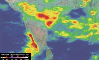
the standard response is to boost expenditures on
dams and other ‘grey’ or built infrastructure. To
achieve water security, however, societies need to
invest as well in ‘green’ or natural infrastructure, Sponge Cities: Flooding is widely
such as wetlands, watersheds and floodplains considered to be the most serious water-
(Boelee et al. 2017). These nature-based solutions related problem affecting many large south
have a proven ability to mitigate the impacts of Asian cities. Rapid urbanisation; land use
water related disasters, while delivering other change and socio-economic development are
developments as well, such as food production and making an already sizeable problem steadily
biodiversity preservation (Nesshöver et al. ,2017). worse. To address the problems of increasing
Nature-based solutions promoting green flooding, water shortage and pollution caused
and blue urban areas have significant potential by the traditional model of urban development,
to decrease the vulnerability and enhance the a new model—the Sponge City, is being
resilience of cities in the light of climate change. developed. The concept is based on natural
Building on existing evidence and needs for future and ecological flows that allow storm water to
science and policy agendas when dealing with be managed with natural infiltration, natural
nature-based solutions are: (i) produce stronger retention and detention, and natural cleaning
evidence on nature-based solutions for climate facilities. It reflects new thinking about how to
change adaptation and mitigation and raise tackle surface-water flooding as well as related
awareness by increasing implementation; (ii) issues in urban water management, such as
adapt for governance challenges in implementing the purification of urban runoff, reduction
nature-based solutions by using reflexive of peak run-off and water conservation. The
approaches, which implies bringing together idea is to make better use of ‘blue’ and ‘green’
new networks of society, nature-based solution spaces in the urban environment for storm
ambassadors, and practitioners; (iii) consider water management and control. This and
socio-environmental justice and social cohesion related practices enhance natural ecosystems
when implementing nature-based solutions by and provide more aesthetically pleasing
using integrated governance approaches that take surroundings for people living and working in
into account an integrative and trans-disciplinary urban environments, in addition to enhancing
participation of diverse actors. Nature-based urban habitats for birds and other organisms.
solutions can serve as climate mitigation and China has already begun to implement this
adaptation tools that produce additional co- approach in several cities, with the aim of
benefits for societal well being, thereby serving as achieving sustainable water use and better
strong investment options for sustainable urban flood control (Fig. 6).
planning (Kabisch et al. 2016).
The solutions are often implemented in an ad-
hoc manner, as is the case with conventional built
Drainage system
infrastructure. Moreover, while there have been
Green land and Part
significant advances in the design and testing of Rain infiltration Residential
nature-based solutions for risk mitigation, they Road and Square
have yet to be fully evaluated and standardised. As
a result, some nature-based projects for climate Final benefi-
adaptation and disaster risk reduction have been ciaries
improperly designed, leading to unsatisfactory Other time-
and unsustainable results. Storage and
There can be no ‘one-size-fits-all’ approach, purification
Sponge city Urban water outlet
given that weather hazards as well as the wider
climatic and ecological conditions are variable
and often poorly understood. Nonetheless, the
conventional engineering sector has a long history
10 OctOber 16 - 31 2018 GeOGraphy and yOu issue 8of fully developed protocols and standards, from Mul, M., Appoh, R., Ghansah, B., Obuobie, E.,
which there is much to learn. Such guidance can Kankam-Yeboah, K., Bekoe-Obeng, E, ...
aid project development and implementation, McCartney, M. (2015). Water resources
while also helping achieve a common assessment of the Volta River Basin. International
understanding of the likely effectiveness of such Water Management Institute.
solutions in reducing risks. Nesshöver C, T Assmuth, KN Irvine, GM Rusch,
KA Waylen, B Delbaere, D Haase, et al. 2017.
endnote “The science, policy and practice of nature-based
The recent incidents of floods across Kerala have solutions: An interdisciplinary perspective”. The
shed a light on the severe problems that induced Science of the Total Environment. 579: 1215-1227.
the flood events. Given the reality of climate Press Trust of India, 2018. Sudden water release
change, these flood disasters will escalate until by Tamil Nadu from Mullaperiyar a reason for
some proactive measures are taken to mitigate deluge: Kerala to SC ”. The Times of India. 23
them. There are several natural and man made August 2018.
ways to reduce the impact of these disasters and Richter, B. D., and G. A. Thomas. 2007. Restoring
ensure societal well-being. environmental flows by modifying dam
operations. Ecology and Society 12(1): 12.
references Roychowdhury A., 2018. Kerala floods: The deluge
Amarnath, G., Alahacoon, N., Smakhtin, V., of 1924 was smaller, but impact was similar, The
Aggarwal, P. 2017. Mapping multiple climate- Indian Express, August 2018
related hazards in South Asia. Colombo, Sri Shenoy J, 2018. Kerala floods may have caused
Lanka: International Water Management Institute damage of Rs 20,000 crore: ASSOCHAM, The
(IWMI).doi: 10.5337/2017.207 Times Of India, August 2018
Babu G. Monsoon havoc in Kerala: 324 lives lost Sinha S, 2018. Insurers say Kerala floods claims may
since May 29, says CM Vijayan. Business Standard touch Rs 500 crore, The Economics Times, August
India. August 18, 2018. 2018.
BBC, 2018. Why the Kerala floods proved so deadly? Tarpanelli A, Amarnath G, Brocca L, Massari
BBC News, August 21. C, Moramarco T, 2017. Discharge estimation
BBC News. Kerala floods: Monsoon water kills and forecasting by MODIS and altimetry
hundreds in Indian State, BBC News, August data in Niger-Benue River. Remote Sensing of
2018. Environment, 195, 96-106.
Boelee, E., Janse, J., Le, G. A., Kok, M., Alkemade, Tarpanelli, A., Santi, E., Tourian, M. J., Filippucci, P.,
R., & Ligtvoet, W. (2017). Overcoming water Amarnath, Gand Brocca, L. 2018. Daily River
challenges through nature-based solutions. Water Discharge Estimates by Merging Satellite Optical
Policy, 19, 5, 820-836. Sensors and Radar Altimetry Through Artificial
G R, 2018. Kerala floods: Death toll rises to 164; 4 Neural Network, IEEE Transactions on Geoscience
districts under severe threat, says CM. The Times and Remote Sensing.
of India, August 2018. Varghese SA, 2018. Kerala floods: Horror and
Kabisch, N., N. Frantzeskaki, S. Pauleit, S. Naumann, heartache at Chengannur. The New Indian
M. Davis, M. Artmann, ... A. Bonn, 2016. Nature- Express, August 2018.
based solutions to climate change mitigation Yoon, T., Rhodes, C., & Shah, F. A., 2015. Upstream
and adaptation in urban areas: perspectives water resource management to address
on indicators, knowledge gaps, barriers, and downstream pollution concerns: A policy
opportunities for action. Ecology and Society framework with application to the Nakdong
21(2):39. River basin in South Korea. Water Resources
Mathrubhumi News, 2018. Attempts to rescue people Research, 2: 787-805.
in Pandanad, Chengannur continue. August 2018
Mathrubhuminews, 2018. Landslides hit several The author is a Research Group Leader at Water Risks and
places in Malabar; Munnar, Wayanad isolated, Disasters, International Water Management Institute,
September 12, 2018. Sri Lanka; a.giriraj@cgiar.org
GeOGraphy and yOu OctOber 16 - 31 2018 11SUBSCRIBE NOW
G’nY : Now Fortnightly From May 2018
Bhugol Aur Aap : : Now Monthly
Special
G’nY Subscription (English) Offer
12 Issues INR 1100@
Bhugol Aur Aap Subscription (Hindi)
24 Issues INR 2160*
6 Copies INR 600
@You save 25%
12 Copies INR 1100 #
*You Save 30%
#You save INR 100
Note : Charges include dispatch by Registered Post Parcel.
Terms & Conditions :
1. Rate and offer valid in India only.
2. Magazine subscription will start within 15 days after receiving of payment.
3. In case subscription request is sent offline please make
DD/ Cheque in favour of “ Iris Publication Pvt. Ltd.”, payable at “New Delhi”.
4. Subscriber can also send money by NEFT/RTGS. Accounts details are given below.
Organization: Iris Publication Pvt. Ltd., Bank name: Andhra Bank,
Branch address: B-1, DAV Public School, Vasant Kunj,
Account number: 107831043010042, IFSC Code: ANDB 0001078
5. You can take subscription online also, please visit our website : www.geographyandyou.com
6. If you pay money by NEFT/RTGS please intimate us through
e-mail : info@geographyandyou.com/amitkumar.gny@gmail.com
7. You can change your subscription address within India, you have
to mail us and you can contact us on Phone No. : 011-46014233, 26186350You can also read