Rivers Road Preserve Land Management Plan - Collier County
←
→
Page content transcription
If your browser does not render page correctly, please read the page content below
Rivers Road Preserve Land Management Plan- First Draft

   Rivers Road Preserve
    Land Management Plan

                    Managed by:
                   Collier County
             Conservation Collier Program

        [Month 2013 – Month 2023 (10 yr plan)]
Prepared by: Collier County Conservation Collier Staff

                             2013

                   Approved by the Collier County Board of County Commissioners on September 23, 2008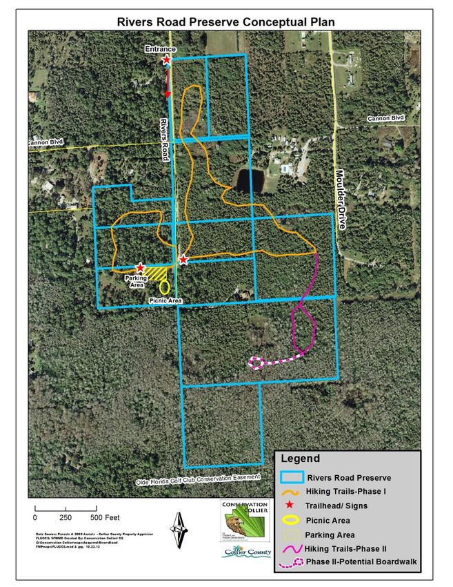
Rivers Road Preserve Land Management Plan First Draft

                                 Rivers Road Preserve

                      Land Management Plan Executive Summary

Lead Agency: Conservation Collier Program, Collier County Parks & Recreation
Department, Collier County Public Services Division

Properties included in this Plan: Folio(s) 00214760000, 00215320009,
00215440002, 00215480004, 00216000001, 00216360000, 00216400009,
00216680007, 00217080004, and 00219120506.

Acreage Breakdown: Currently 76.74 acres

Management Responsibilities: Collier County Conservation Collier Program staff

Designated Land Use: Hiking, Nature Photography and Bird Watching.

Unique Features:

Management Goals:
Goal 1: Eliminate or Reduce Human Impacts
Goal 2: Exotics Removal and Management
Goal 3: Appropriately Manage Wildlife
Goal 4: Create and Implement a Prescribed Fire Program
Goal 5: Restoration of Native Vegetation
Goal 6: Preserve Prepared For Public Access
Goal 7: Facilitate Uses of the Site for Educational Purposes
Goal 8: Officially Open the Preserve for Public Access
Goal 9: Provide a Plan for Disaster Preparedness
Goal 10: Coordination with Stakeholders, Partners, and Regional Agencies

Acquisition Needs: None

Surplus Lands: None

Public Involvement: A Public meeting(s) will be held to discuss this Final
Management Plan. The meeting is open to the general public and neighboring
property owners will receive a written invitation. Specifically, these meetings give
the general public the opportunity to learn about the Conservation Collier Program,
future land management plans and the potential for public use at the Rivers Road
Preserve. This forum also allows the public to voice any concerns or objections
they may have with any of these issues as presented here in the Final Land
Management Plan.
 Conservation Collier Program                 ii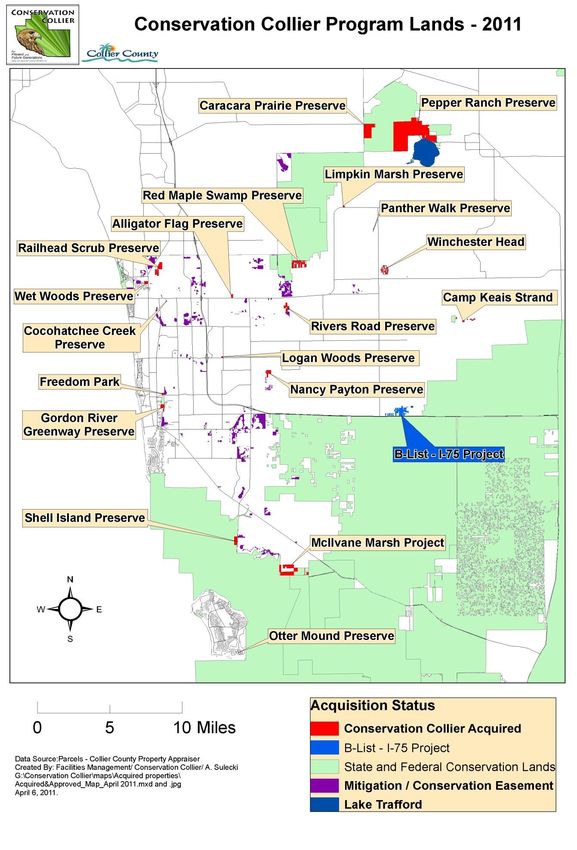
Rivers Road Preserve Land Management Plan First Draft

                                                                    Table of Contents

LAND MANAGEMENT PLAN EXECUTIVE SUMMARY .................................................. II

LIST OF FIGURES .................................................................................................................... IV

LIST OF TABLES ........................................................................................................................ V

1.0 INTRODUCTION....................................................................................................................6

1.1 Conservation Collier: Land Acquisition Program and Management Authority ............................................. 7

1.2 Purpose and Scope of Plan .................................................................................................................................... 7

1.3 Location .................................................................................................................................................................. 7

1.4 Regional Significance........................................................................................................................................... 10

1.5 Nearby Public Lands and Designated Water Resources .................................................................................. 10

1.6 Public Involvement .............................................................................................................................................. 13

2.0 NATURAL AND CULTURAL RESOURCES ...................................................................13

2.1 Physiography........................................................................................................................................................ 13
  2.1.1 Topography and Geomorphology ................................................................................................................... 13
  2.1.2 Hydrology/Water Management ...................................................................................................................... 13
  2.1.3 Geology .......................................................................................................................................................... 13
  2.1.4 Soils ................................................................................................................................................................ 14

2.2 Climate.................................................................................................................................................................. 14

2.3 Natural Plant Communities ................................................................................................................................ 15

2.4 Native Plant and Animal Species ........................................................................................................................ 17

2.5 Listed Species ....................................................................................................................................................... 19
  2.5.1 Listed Plant Species ........................................................................................................................................ 19
  2.5.2 Listed Wildlife Species DOES THIS NEED TO BE REQUESTED FROM FNAI? ..................................... 20

2.6 Invasive, Non-Native and Problem Species ....................................................................................................... 22
  2.6.1 Exotic Wildlife Species .................................................................................................................................. 22
  2.6.2 Invasive and Problem Plant Species ............................................................................................................... 22

2.7 Forest Resources .................................................................................................................................................. 23

2.8 Archaeological, Historical and Cultural Resources .......................................................................................... 23

3.0 USE OF THE PROPERTY ...................................................................................................24

3.1 Previous and Current Use ................................................................................................................................... 24

3.2 Planned Uses and Assessment of their Impacts ................................................................................................ 25
  Conservation Collier Program                                                        iii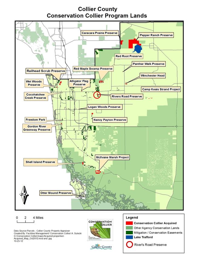
Rivers Road Preserve Land Management Plan First Draft

3.3 Identification of Public Uses Consistent with Preservation, Enhancement, Restoration, Conservation and
Maintenance of the Resources. ................................................................................................................................. 25

3.4 Planned Public Uses and Assessment of their Impacts ..................................................................................... 25

3.5 Adjacent Land Uses ............................................................................................................................................. 26

3.6 Prospective Land Acquisitions ........................................................................................................................... 26

3.5 Analysis of Multiple-Use Potential ..................................................................................................................... 27

3.6 Proposed Single - or Multiple - Use Management ............................................................................................ 27

 4.0 FUTURE USE OF THE RIVERS ROAD PRESERVE INCLUDING MANAGEMENT
ISSUES, GOALS AND OBJECTIVES ......................................................................................27

4.1 Management Plan Framework ........................................................................................................................... 27

4.1.1 Preserve Manager: Contact Information ....................................................................................................... 28

4.1.3 Preserve Rules and Regulations ...................................................................................................................... 28

4.2 Desired Future Conditions .................................................................................................................................. 28

4.3 Major Accomplishments during previous years ............................................................................................... 28

4.4 Goals and Objectives for 10 year period............................................................................................................ 28

                                                                   List of Figures

Figure 1. Rivers Road Preserve Location Map
Figure 2. Rivers Road Preserve 20## Aerial View
Figure 3. Conservation Collier Preserves and Designated State and Federal Land or
          Conservation Easements Existing in Collier County
Figure 4. Collier County Conservation Areas and Designated Conservation Easements
Figure 5. Rivers Road Preserve Lidar Elevations Map
Figure 6. Rivers Road Preserve Land Cover / Land Use Map
Figure 7. 1940’s Aerial Photo
Figure 8. 1962 Aerial Photo
Figure 9. Rivers Road Preserve Easements and Access
Figure 10. Potential Properties Recommended for Future Acquisition
Figure 11. Photo Point Locations at Rivers Road Preserve
Figure 12. Prescribed Fire Map -Fire Breaks and Previous Wildfire Areas
Figure 13. Conceptual Plan for Rivers Road Preserve

 Conservation Collier Program                                                     iv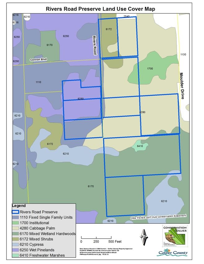
Rivers Road Preserve Land Management Plan First Draft

                                                  List of Tables- To be finalized
Table 1: Acquisition History and Status of Rivers Road Preserve ................................................................................6
Table 2: Public Lands Located Near the Rivers Road Preserve .................................................................................. 10
Table 4: List of Avian Species Recorded on the Site ................................................................................................. 18
Table 5: Breeding Bird Species Recorded in the Belle Meade NW Quadrangle Encompassing the Rivers Road
    Preserve (* = non-indigenous) ............................................................................................................................. 18
Table 6: Listed Plant Species Detected at the Rivers Road Preserve ......................................................................... 19
Table 7: Listed Wildlife Species Found or Potentially Found at Rivers Road Preserve .............................................. 21
Table 8: Exotic Plant Species at Rivers Road Preserve ............................................................................................... 23
Table 9: Analysis of Multiple-Use Potential ............................................................................................................... 27
Table 10: Major Accomplishments.............................................................................................................................. 28
Table ##: Invasive, Exotic Plant Species Control Plan for the Rivers Road Preserve ................................................. 31
Table ##. Estimated Annual Land Management Budget ..............................................................................................1

                                                       List of Appendices -TBD
Appendix 1: Legal Description of the property and Plat Maps
Appendix 2: List of plant species observed at the Rivers Road Preserve
Appendix 3: Florida Natural Areas Inventory Managed Area Tracking Record and Element
            Occurrence Summary; FNAI ranking system explanation and
            Natural Communities Descriptions for Occurring Natural Communities
Appendix 4: Potential Adjacent Properties to Pursue for Future Acquisition
Appendix 5: Draft Example of Prescribed Fire Plan
Appendix 6: Safe Harbor Agreement with FFWCC and USFWS

 Conservation Collier Program                                                   v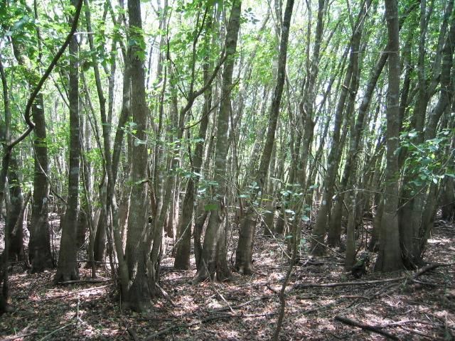
Rivers Road Preserve Land Management Plan First Draft

                                       1.0 Introduction
The Rivers Road Preserve is a 76.74-acre preserve located approximately 2.5 miles east of
Collier Boulevard (CR 951) within the Rural Fringe Mixed Use District (Receiving Area) in
Collier County, Florida. Current access to the preserve is from Rivers Road on the west or from
Moulder Drive to the east. The preserve is comprised of a mix of vegetative communities,
including pine flatwoods, mixed wetland hardwoods, cypress and wetland forested mixed, with
small areas of freshwater marsh and inland ponds and will serve the public as a wildlife viewing
area.

The Preserve was purchased by Collier County in two phases. The first 71.9 acres were
purchased in December 2008, followed by an additional 4.84 acres in 2010. The County holds
fee simple title. The preserve was officially named on December 22, 2008. The preserve will be
open to the public, and available for educational tours for local schools and groups. A nature
trail, benches, picnic tables and educational interpretive signs will be provided for visitors.

The Conservation Collier Program manages this parcel under authority granted by the
Conservation Collier Ordinance 2002-63, as amended (available from www.municode.com ).
Conservation, restoration and passive public recreation are the designated uses of the property.
Management activities allowed are those necessary to preserve and maintain this
environmentally sensitive land for the benefit of present and future generations. Public use of
this site must be consistent with these goals.

         Table 1: Acquisition History and Status of Rivers Road Preserve
  Year                                           Benchmark
 2007      Property nominated to the Conservation Collier Program
 2007      Initial site assessment by Conservation Collier staff
 2007      Approval of Initial Criteria Screening Report for first 9 properties by the Conservation
           Collier Land Acquisition Advisory Committee
 2008      Approval of Initial Criteria Screening Report for two additional properties by the
           Conservation Collier Land Acquisition Advisory Committee
 2008      62.98 acres approved for purchase by the Board of County Commissioners (BCC).
           Closed on properties in December 2008.
 2010      13.76 acres approved for purchase by the Board of County Commissioners (BCC).
           Closed on remaining properties in January 2010
 2011      Developed Interim Management Plan- BCC approved
 2008      Officially named Rivers Road Preserve
 2013      Completed Final Management Plan

An Interim Management Plan for Rivers Road Preserve was approved by the Collier County
Board of County Commissioners (BCC) in 2011. This is the Final Management Plan for the
Rivers Road Preserve. This management plan will be submitted to the BCC for approval. When
approved, this plan will replace the Interim Management Plan. Updates to the plan will be
completed every 5 years.

 Conservation Collier Program                    6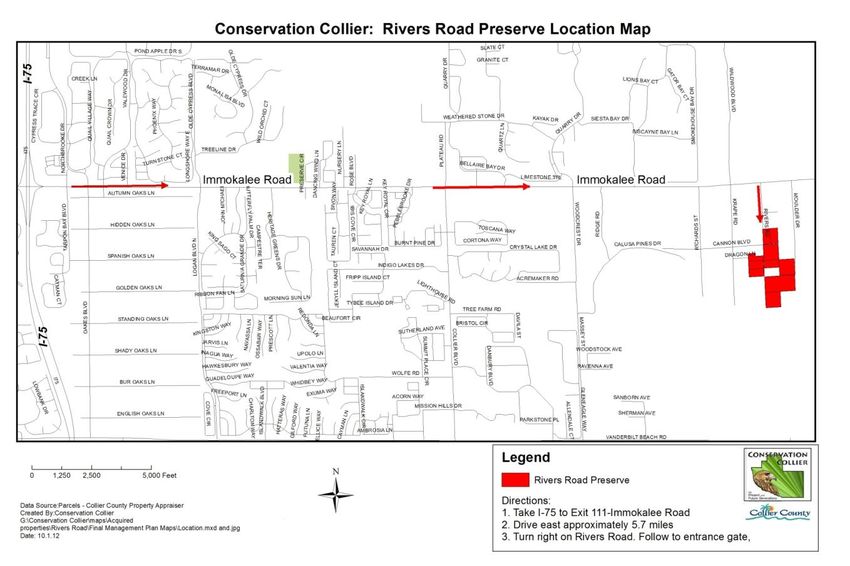
Rivers Road Preserve Land Management Plan First Draft

1.1 Conservation Collier: Land Acquisition Program and Management Authority
The Conservation Collier Program was originally approved by voters in November 2002 and
subsequently confirmed in the November 2006 ballot referendum. Both voter-approved
referendums enable the program to acquire environmentally sensitive lands within Collier
County, Florida (Ordinance 2002-63, as amended). Properties must support at least two of the
following qualities to qualify for consideration: rare habitat, aquifer recharge, flood control,
water quality protection, and listed species habitat. The BCC appointed a Conservation Collier
Land Acquisition Advisory Committee (CCLAAC) to consider any selected or nominated
properties that an owner has indicated a willingness to sell. The committee recommends
property purchases for final approval by the BCC.

Lands acquired with Conservation Collier funds are titled to “COLLIER COUNTY, a political
subdivision of the State of Florida, by and through its Conservation Collier program.” The
Board of County Commissioners of Collier County established the Conservation Collier Program
to implement the program and to manage acquired lands. As such, Conservation Collier holds
management authority for the Rivers Road Preserve.

1.2 Purpose and Scope of Plan
The purpose of the plan is to provide management direction for the Rivers Road Preserve by
identifying the goals and objectives necessary to eliminate or minimize any threats to the
resources and integrity of the preserve. This text is a working document that establishes the
foundation of a ten-year plan by identifying the appropriate management techniques necessary to
preserve and/or restore the resource.
This plan will balance resource restoration and protection with natural resource-based
recreational and educational use while looking at listed species protection and maintenance of
the site free of invasive, exotic plant and animal species. This plan is divided into sections that
incorporate an introduction, descriptions of the natural and cultural resources, projected uses of
the property, and management issues, goals and objectives.

1.3 Location
The Rivers Road Preserve property is located approximately 2.5 miles east of Collier Boulevard
(CR 951) within the Rural Fringe Mixed use District (Receiving Area) in Collier County, Florida
(Figure 1 & 2). Single family homes exist to the north, east and west of the property, with one
private residence within the boundaries of the preserve. A church encompassing several parcels
exists to the north and northeast of the property along with a parcel that contains remnants of a
small tree nursery. A conservation easement exists to the south of the property. Collier County
District Schools owns a little over 20 acres of land to the northeast of the property along
Immokalee Road, however the District does not plan to build any new schools within the next 5
years.

It is located in Township 48, Range 27 and Section 30, in Collier County, Florida. The legal
descriptions and area plat maps are attached as Appendix #.

 Conservation Collier Program                   7
Rivers Road Preserve Land Management Plan First Draft

Figure 1: Rivers Road Preserve Location Map

       Conservation Collier Program               8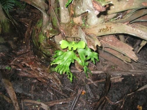
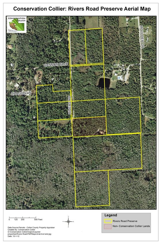
Rivers Road Preserve Land Management Plan First Draft

Figure 2: Rivers Road Preserve Aerial View
Conservation Collier Program                 9
Rivers Road Preserve Land Management Plan First Draft

1.4 Regional Significance
Despite having 876,990 acres, or 68%, of County lands protected in conservation status (FNAI,
July 2012). Collier County has lost, and is losing, many of its rare and unique habitats (Figures 3
and 4). The Conservation Collier Ordinance (2002-63, as amended) identifies these specific
habitats and gives preference to them in acquisition evaluations. These habitats include, in order
of preference: tropical hardwood hammocks, xeric oak scrub, coastal strand, native beach,
riverine oak, high marsh (saline) and tidal freshwater marsh. Although the Rivers Road Preserve
does not contain any of these preferred habitats; it does contain eight observed native plant
communities and outstanding examples of pop ash swamp, other wetland dependent plant
species and several listed plant species such as common-stiff leaved wild pine, hand fern and
reflexed wild pine. The habitat observed and the location supports the presence of
approximately nine listed species and many non-listed wildlife species. This preserve provides
habitat for the listed Florida panther (Puma concolor coryi) with several telemetry points
recorded in close proximity. The protection and management of these listed species and their
habitat is critical to their long term existence in Collier County and throughout their ranges.

1.5 Nearby Public Lands and Designated Water Resources
Conservation Lands, in order of increasing distance are identified in Table 2 below.

                    Table 2: Public Lands Located Near the Rivers Road Preserve
       Preserve Name              Distance (miles)             Direction                 Type
                                                                                 County / Conservation
  Red Maple Swamp Preserve               2.5                       N
                                                                                        Collier
                                                                                 County / Conservation
    Alligator Flag Preserve              4                         W
                                                                                        Collier
                                                                                 County / Conservation
    Nancy Peyton Preserve                5                         S
                                                                                        Collier
                                                                                 County / Conservation
    Logan Woods Preserve              5.5 miles                   NW
                                                                                        Collier
                                                                                 County / Conservation
       Winchester Head                   8                        NE
                                                                                        Collier
 Picayune Strand State Forest          8 miles                     S                     State
                                                                                 County / Conservation
   Limpkin Marsh Preserve                10                       NE
                                                                                        Collier
                                                                                 County / Conservation
   Railhead Scrub Preserve               10                       NW
                                                                                        Collier
   Florida Panther National
                                      10 miles                     SE                   National
       Wildlife Refuge
                                                                                 County / Conservation
    Panther Walk Preserve                11                       NE
                                                                                        Collier
                                                                                 County / Conservation
      Camp Keais Strand                  12                        E
                                                                                        Collier
                                                                                 County / Conservation
    Pepper Ranch Preserve                15                       NE
                                                                                        Collier
                                                                                 County / Conservation
   Caracara Prairie Preserve             15                       NE
                                                                                        Collier

 Conservation Collier Program                      10
Rivers Road Preserve Land Management Plan First Draft Figure 3. Conservation Collier Preserves and Designated State and Federal Land or Conservation Easements Existing in Collier County Conservation Collier Program 11
Rivers Road Preserve Land Management Plan First Draft

 Figure 4: Collier County Conservation Areas

Conservation Collier Program               12
Rivers Road Preserve Land Management Plan First Draft
1.6 Public Involvement
Neighborhood involvement will be sought through direct mailing notices for public meetings to
residents within the surrounding area, owners of properties that border the preserve, and
organizations with an interest in the preserve. Any major changes or management activities,
such as prescribed fire that are likely to generate an intrusive aspect or that in some way affect
neighboring properties will be reviewed with these contacts prior to conducting the activity.
Staff will also seek volunteers through these contacts. Preserve activities will be posted on the
Conservation Collier website and also through public notices.
2.0 Natural and Cultural Resources
2.1 Physiography
The Rivers Road Preserve lies within the Southwestern Flatwoods District. This largely low, flat
district was developed on rocks and sediments that range mainly form Miocene to Pleistocene in
age. Surficial materials are dominantly sand (often with relatively clayey substrate) limestone
and organic deposits (Myers & Ewel 1990).
2.1.1 Topography and Geomorphology
The preserve is located in the ## region of the South Florida Water Management District.
Topography has been established using a Light Detecting and Ranging (LIDAR) map (Figure 5).
The average elevation of the surrounding lands is ## feet according to North American Vertical
Datum (NAVD 1988).
2.1.2 Hydrology/Water Management
Flat topography, sandy soils and seasonal precipitation strongly influence hydrological processes
in flatwoods. During the rainy season, flatwood soils become saturated and poorly aerated and
there may be standing water for varying periods of time. During the dry season however, high
evapotranspiration draws much water from the upper horizons thus soil moisture becomes
rapidly depleted and persistent droughty conditions result (Myers & Ewel 1990). A small pond
was excavated in 2000 on a residential property to the east of the preserve, with a portion of the
pond within the preserve. The northern portion of the preserve has an unpaved road running
alongside the western boundary while another unpaved road is just beyond the eastern boundary.
In between the two roads and to the north of the preserve are just over 30 acres of land currently
being used for church buildings and mostly cleared open space. To the south of the property is
the Olde Florida Golf Course Conservation Area that was set aside when the golf course was
built in the early 1990s. No water management structures exist on the preserve and no water
management improvements are planned for the future. The property is mapped by the South
Florida Water Management District (SFWMD) to contribute significantly to the Lower Tamiami
aquifer at 21-102” annually and the surficial aquifer significantly at 56-67” annually.
2.1.3 Geology
The geology of Collier County is characterized by complex sequences of interbeded sands, clays,
and limestone. Closest to the surface is the Holocene aged Pamlico Sand Formation,
approximately ten feet thick and composed primarily of unconsolidated quartz sand and some
silt. The Pamlico Sand unconformably overlies the Pleistocene aged Fort Thompson and
Caloosahatchee Formations, which vary from a few feet to more than twenty feet in thickness
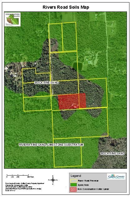
Conservation Collier Program 13Rivers Road Preserve Land Management Plan First Draft and are characterized by shelly and sandy limestone with vugs and solution cavities (Miller 1986). Below the Fort Thompson and Caloosahatchee Formations are the Ochopee and Buckingham Members of the Pliocene aged Tamiami Formation, which are at least 200 feet thick in the surrounding areas (Oaks & Dunbar 1974). The Ochopee Limestone unconformably overlies the Buckingham Limestone and/or the equivalent Cape Coral Clay. This unconformity marks the bottom of the surficial aquifer separating it from the brackish underlying aquifer below. Then the Hawthorn Formation, rich in phosphate and other heavy minerals (Scott 1988), overlies the Oligocene age Suwannee Limestone and Eocene age Ocala Limestone that form the Floridian Aquifer System in Southwestern Florida. 2.1.4 Soils Soils data is based on the Soil Survey of Collier County, Florida (USDA/NRCS, 1990, rev. 1998). Approximately 55% of the soils mapped on this preserve are Riviera fine sand, limestone substratum, a hydric soil. This nearly level, poorly drained slough soil usually supports scattered areas of South Florida slash pine, cypress cabbage palm, wax myrtle, sand cord grass, gulf muhly, blue maidencane, South Florida Bluestem and chalky bluestem. Vegetation observed in the preserve areas containing this soil includes South Florida slash pine, cypress, cabbage palm, and wax myrtle. Approximately 45% of the soils mapped on this preserve are Boca fine sand, a non-hydric soil. This nearly level, poorly drained soil usually supports scattered areas of pine and cabbage palm and an understory of saw palmetto, chalky bluestem, creeping bluestem, lopsided Indiangrass, and pineland threeawn. Vegetation observed on the preserve where these soils are contained includes cabbage palms with an understory of saw palmetto and some pines. 2.2 Climate The Rivers Road Preserve is located in an area of Florida that is influenced by both a humid subtropical climate and a tropical savanna climate in which temperatures are moderated by winds from the Gulf of Mexico and the Atlantic Ocean. A tropical savanna climate is characterized by sharply delineated wet and dry seasons and average monthly temperatures greater than 64º Fahrenheit. Monthly rainfalls may exceed ten inches during the wet season. Humid subtropical climates are characterized by less extreme rainfall fluctuations between wet and dry seasons and average monthly temperatures less than 64º Fahrenheit in some months. Conservation Collier Program 14
Rivers Road Preserve Land Management Plan First Draft

The average annual temperature for this portion of Collier County is approximately 75º
Fahrenheit. The warmest months are usually July and August. The humidity is high during
these months but frequent afternoon thunderstorms prevent excessively high temperatures.

Two-thirds of the annual rainfall occurs in the wet season from May to October. Thunderstorms
are frequent during the wet season occurring every two out of three days between June and
September. Rainfall records for the area indicate that there is no significant variation in the
annual rainfall throughout much of the county; however, large variations often occur during a
single year. The hurricane season extends from June through November with peak activity
occurring in September and October when ocean temperatures are highest.

2.3 Natural Plant Communities
A plant community refers to the suite of plant species that form the natural vegetation of any
place. In addition to anthropogenic influence, the combination of factors such as geology,
topography, hydrology, underlying soils and climate determine the types of plants found in an
area. These plants in turn determine the animal species that may be found in an area.
The Florida Land Use, Land Cover Classification System (FLUCCS) GIS layer provided by the
South Florida Water Management District classifies the entire preserve as a combination of Pine
Flatwoods-Melaleuca Infested, Mixed Wetland Hardwoods, Cypress-Melaleuca Infested and
Wetland Forested Mixed (Figure 6). Site evaluations confirm the Pine Flatwoods, Mixed
Wetland Hardwoods, Cypress and Wetland Forested mixed designations, however, very few
melaleuca trees were observed throughout the preserve. Other communities observed include
Freshwater Marsh, Cabbage Palm, Pine/Cabbage Palm, Cypress/Cabbage Palm Disturbed,
Cypress, Pine, Cabbage Palm, and Inland Ponds and Sloughs.

The preserve also has several cleared areas, several areas designated for single family residences,
a portion of a small pond excavated in 2000 and several infestations of exotic plants, including
25-40% coverage of Brazilian Pepper (Schimus terebinthifolius) and a significant infestation of
air potato (Dioscorea bulbifera) throughout on the western side of the preserve and on the
southeastern portion as well. Additional details are provided in Section 2.6 and plans for
management of exotics will be covered in Invasive, Exotic Plant Species Control Plan (Table
###).

 Conservation Collier Program                   15
Rivers Road Preserve Land Management Plan First Draft

  Figure 6: Rivers Road Preserve Land Cover / Land Use Map

Conservation Collier Program              16
Rivers Road Preserve Land Management Plan First Draft
2.4 Native Plant and Animal Species
The 77-acre preserve is a combination of Cabbage Palm, Inland Ponds and Sloughs, Mixed
Wetland Hardwoods, Cypress, Pine Flatwoods, Mixed Wetland Forests and Freshwater Marsh.
The preserve also contains an outstanding example of pop ash swamps and several wetlands.
Sixty-four (64) plant species were recorded at Rivers Road Preserve in 2007 (Appendix 2). Of
these sixty four plants, ten (10) are exotics and most require removal and maintenance. The
canopy is dominated by slash pine trees (Pinus elliottii), cabbage palms (Sabal palmetto), and
scattered cypress (Taxodium ascendens), with a canopy of willow (Saliz caroliniana), pop ash
(Fraximus caroliniana) and red maple (Acer rubrum) adjacent to the wetland areas. The
midstory contains areas of ragweed (Ambrosia sp.), dogfennel (Eupatorium capillifolium),
sawgrass (Cladium jamaicense), saw palmetto (Serenoa repens), American Beautyberry
(Callicarpa americana) and myrsine (Rapanea punctata). The groundcover is a comination of
ferns such as Bracken fern (Pteridnum aquilimum), swamp fern (Blechmaum serrulatum), chain
fern (Woodwardia virginica), alligator flag (Thalia geniculata) and sagittaria (Sagittaria
lancifolia), amongst other groundcovers common in Pine/Cabbage Palm communities and
freshwater marsh communities. Ephiphytes and vines have been observed throughout the
preserve. Listed plant species include common wild pine (Tillandsia fasciulata), hand fern
(Ophioglossum palmatum) and reflexed (inflated) wild pine (Tillandsia balbisiana).
Occurrences of fauna at the preserve are based on direct
visual and auditory observations of animals by Collier
County staff and outside researchers during site visits or
evidence of activity such as spoor, scat, or burrows, and
from the site information available in documents such as:
the site’s initial criteria screening report,
the property’s interim management plan,
anecdotal information from persons with
knowledge of the site.
Hand fern found on site.
Photo taken by Conservation Collier staff.
Mammal species known to occur or individuals and/or evidence of activity directly observed
within the preserve include the White-tailed Deer (Odocoileus virginianus), Florida Black bear
(Ursus americanus floridanus), and wild feral hogs (Sus scrofa). Numerous Florida panther
(Puma concolor coryi) telemetry points have been recorded in the area and one point was
recorded approximately 1/3 mile from the preserve. There are anecdotal reports of panthers on
the southern portion of the preserve. There is a wildlife underpass under Immokalee Road north
of the preserve that provides access through the Twin Eagles subdivision to over 60,000 acres of
conservation lands, including state-owned lands, Audubon’s Corkscrew Swamp and the CREW
Trust lands.
Conservation Collier Program 17Rivers Road Preserve Land Management Plan First Draft
Bird observations by Collier County staff are included in Table 4.
Table 4: List of Avian Species Recorded on the Site
Common Name Scientific Name Common Name Scientific Name
Red-winged Blackbird Agelaius phoeniceus Gray Catbird Dumetella carolinensis
Red-shouldered Hawk Buteo lineatus Blue Jay Cyanocitta cristata
Mourning Dove Zenaidura macroura Blue-gray Gnatcatcher Polioptila caerulea
Common Ground-dove Columbina passerina White-eyed Vireo Vireo griseus
Red-bellied
Melanerpes carolinus Northern Cardinal Cardinalis cardinalis
Woodpecker
Turkey Vulture Cathartes aura Wild Turkey Meleagris gallopavo
The Florida Breeding Bird Atlas lists 32 bird species that have been
recorded as confirmed, probable, or possible breeding in the
vicinity of the site (in Corkscrew SW USGS quadrangle) that may
be present at Rivers Road Preserve (Table 5). The Breeding Bird
Atlas documents breeding distributions of all bird species in Florida
between 1986 and 1991. Some of these species may breed at
Rivers Road Preserve.
Wild Turkey on the River Road Preserve
Photo Taken by Hans Van Cleave
Table 5: Breeding Bird Species Recorded in the Belle Meade NW Quadrangle
Encompassing the Rivers Road Preserve (* = non-indigenous)
Common Name Scientific Name Common Name Scientific Name
Northern Bobwhite Colinus virginianus Purple Martin Progne subis
Green Heron Butorides striatus Northern Rough-winged Stelgidopteryx
Swallow serripennis
Swallow-tailed Kite Elanoides forficatus Tufted Titmouse Parus bicolor
Red-shouldered Hawk Buteo lineatus Carolina Wren Thryothorus
ludovicianus
Mourning Dove Zenaida macroura Blue-gray Gnatcatcher Polioptila caerulea
Common ground dove Columbina passerina Northern Mockingbird Mimus polyglottos
Yellow-billed Cuckoo Coccyzus americanus Brown Thrasher Toxostoma rufum
Barn Owl Tyto alba Pine Warbler Dendroica pinus
Common Nighthawk Chordeiles minor Prairie Warbler Setophaga discolor
Red-bellied Melanerpes carolinus Common Yellowthroat Geothlypis trichas
Woodpecker
Downy Woodpecker Picoides pubescens Eastern Towhee Pipilo erythrophthalmus
Red-cockaded Picoides borealis Northern Cardinal Cardinalis cardinalis
Woodpecker
Great Crested Myiarchus crinitus Red-winged Blackbird Agelaius phoeniceus
Flycatcher
Loggerhead Shrike Lanius ludovicianus Eastern Meadowlark Sturnella magna
White-eyed Vireo Vireo griseus Common Grackle Quiscalus quiscula
Blue Jay Cyanocitta cristata Boat-tailed Grackle Quiscalus major
Conservation Collier Program 18Rivers Road Preserve Land Management Plan First Draft
Breeding Bird Atlas Explorer (online resource). 2012. U.S. Geological Survey Patuxent Wildlife Research Center & National Biological Information Infrastructure
http://www.pwrc.usgs.gov/bba. Data extracted from: Florida's breeding bird atlas: A collaborative study of Florida's birdlife. 2003. Florida Fish and Wildlife
Conservation Commission. http://www.wildflorida.org/bba/.
The only reptile species observed on the preserve is the
Cottonmouth/Water Moccasin (Agkistrodon piscivorous conanti)
and the Southern Black Racer (Coluber constrictor priapus). There
have been no amphibian species observed on the site to date,
however staff will continue to monitor the site during site visits and
note any amphibians or other animal seen during these visits.
Cottonmouth Snake on the Rivers
Road Preserve Photo Taken by
Hans VanCleave
Invertebrates observed at the preserve include butterflies such as
Queen (Danaus gilippus) and Zebra Longwing (Heliconius
charithonia. Other wildlife species noted on the preserve include
the Tree Snail (Order Pulmanata), and Crayfish (Order Decapoda).
Other wildlife species that have not been recorded undoubtedly
occur at Rivers Road Preserve. Future, more detailed, wildlife
surveys will be conducted on the preserve and the plan will be
updated as new species are documented.
Tree Snail. Photo taken by County
Staff on the Rivers Road Preserve
2.5 Listed Species
Official listings of rare and endangered species are produced at the federal level by the U.S. Fish
and Wildlife Service and the National Marine Fisheries Service, and at the state level by the
Florida Fish and Wildlife Conservation Commission and the Florida Department of Agriculture
and Consumer Services. FNAI produces a list of rare and endangered species, and maintains a
database of occurrences of these species in Florida.
2.5.1 Listed Plant Species
Three plant species found at the Rivers Road Preserve are listed by the Florida Department of
Agriculture and Consumer Services (FDACS) - (2) as Endangered, (1) as Threatened, and none
as Commercially Exploited. There are no federally listed endangered or threatened plant species
A brief description of these species and their status is included in Table 6 and in the following
paragraphs.
Table 6: Listed Plant Species Detected at the Rivers Road Preserve
Common Names Scientific Names FDACS (State)
Stiff-leaved wild pine Tillandsia fasciculata Endangered
Reflexed wild pine Tillandsia balbisiana Threatened
Hand fern Ophioglossum palmatum Endangered
Additional listed plant species may be found at Rivers Road Preserve following further field
surveys. Confirmation of listed plant identifications should be made by a qualified botanist.
Stiff-leaved wild pine (Tillandsia fasciculata)
Conservation Collier Program 19Rivers Road Preserve Land Management Plan First Draft
Although this air plant is abundant throughout South Florida, it is listed by
the State as endangered as they are threatened by the Mexican Bromeliad
weevil. Leaves may grow to as much as forty inches, they form large
plants in tree tops and are often mistaken for bird or squirrel nests. They
grow equally well in canopy or near ground (NAS 2007). It is also
referred to as a common wild pine or cardinal air plant. This air plant has
been noted in several areas throughout the preserve. The photo to the left
was taken in the northern portion of the preserve within a small pop ash
marsh.
Stiff-leaved wild pine
Photo by Collier County Staff
Reflexed wild pine (Tillandsia balbisiana)
This air plant is abundant and occurs throughout the preserve. It is also
considered threatened by the State of Florida due to the Mexican Bromiliad
Weevil. It is equally well-adjusted to deep shade where leaves grow long or
to bright sunlight where they are contorted and highly colored from gray-
green to blue-bronze or red (NAS 2007).
Reflexed Wild Pine
Photo by Melissa Abdo
Courtesy of The Institute
for Regional Conservation
Hand Fern (Ophioglossum palmatum) NEED PHOTO THAT WAS TAKEN FOR ICS OR NEW PHOTO
This plant is commonly found on cabbage palms and has been found in multiple areas along the
east and southern coast of Florida. Early 20th century observers spoke of hand fern gathered by
the wagon load from Florida’s swamps. Hand fern is still collected but it dies in cultivation due
to lack of essential fungi. When palm boots decay and fall to the ground, or are destroyed by
fire, hand ferns are killed. Only 50 populations remain in Florida, about half in conservation
areas.
2.5.2 Listed Wildlife Species
The Florida Natural Areas Inventory (FNAI) maintains a database of occurrences of rare,
threatened, and endangered species in Florida. Within the Rivers Road Preserve, FNAI has
documented the occurrence of the endangered Florida panther (Puma concolor coryi) (Appendix
#). The FNAI database report indicated (3) other species likely to be found in this area including
Florida back bear (Ursus americanus floridanus), Mangrove fox squirrel (Sciurus niger
avicennia), and the Wood stork (Mycteria americana). Florida black bear have been detected and
documented by the former property owners on the southern portion of the preserve. The habitat
of the preserve also supports the presence of Gopher tortoise (Gopherus polyphemus), Eastern
indigo snake (Drymarchon couperi), Florida bonneted bat (Eumops floridanus), and Snail kite
(Rostrhamus sociabilis plumbeus). The table below identifies the status of each and a brief
description of the only documented listed species is included in the following paragraphs.
Conservation Collier Program 20Rivers Road Preserve Land Management Plan First Draft
Cottonmouth/Water Moccasin (Agkistrodon piscivorous conanti) have also been observed on the
preserve.
Table 7: Listed Wildlife Species Found or Potentially Found at Rivers Road Preserve
Observed
Common Name Scientific Name Federal State FNAI or Potential
Florida black bear Ursus americanus floridanus T L O
Cottonmouth/Water Moccasin Agkistrodon piscivorous conanti T SSC O
Florida panther Puma concolor coryi E E D O
Big Cypress fox squirrel Sciurus niger avicennia T L P
Wood Stork Mycteria americana E E L P
Florida Burrowing Owl Athene cunicularia floridana SSC P P
Eastern Indigo Snake Drymarchon couperi T T P P
Florida bonneted bat Eumops floridanus T P P
Red-cockaded Woodpecker Picoides borealis E E P P
Snail Kite Rostrhamus sociabilis plumbeus E E P P
E – Endangered, T – Threatened, SSC – Species of Special Concern, O – Observed, P – Potential, L-Likely
Florida black bear (Ursus americanus floridanus)
Historically ranged across nearly all of Florida. Currently, occurs discontinuously across the state
with substantial populations in the Apalachicola to Big Bend area, Baker and Columbia counties,
Ocala National Forest region, and Collier to Highlands counties. Black bears use a wide variety
of forested types, pine flatwoods, hardwood swamp, cypress swamp, hammocks, xeric oak scrub,
and mixed hardwood-pine. As with black bears in other parts of their range, seasonal changes in
habitat use occur in response to food availability.
Black Bear photos taken in the Rivers
Road Preserve. Photos taken by Hans
VanCleve.
Cottonmouth/Water Moccasin (Agkistrodon piscivorous conanti)
Cottonmouth snakes are listed as a species of special concern by the State of Florida. The coloration of
this snake can be variable. Older and larger snakes tens to be uniformly black, brown to reddish
brown, while the young are banded with a dark color against a lighter background. Most
abundant in flooded woodlands, the Florida Cottonmouth is also found around rivers, streams
and ponds. It is often seen along the water's edge, on the bank or on a log or rock and it can also
be found in pine woods or other dry habitats. Though the Cottonmouth occurs throughout the
state, it is not as abundant as the many species of harmless water snakes that occur in much the
same habitat.
Florida Panther (Puma concolor coryi)
The Florida Panther is listed as a Federally and State endangered species. The U.S. Fish and
Wildlife Service and FWC track radio-collared panthers in Collier County. The radio telemetry
reports have indicated that Panthers do pass through this area. These large cats require extensive
Conservation Collier Program 21Rivers Road Preserve Land Management Plan First Draft
blocks of mostly forested communities. Large wetlands that are generally inaccessible to
humans are important for diurnal refuge.
2.6 Invasive, Non-Native and Problem Species
Several invasive, non-indigenous plant and animal species are known to occur within Florida. A
comprehensive list of invasive plant species is available from the Florida Exotic Pest Plant
Council (FLEPPC). Although Florida does not have an official invasive, non-indigenous animal
species list, at least 400 exotic fish and wildlife animal species have been reported, and
approximately 125 species are established.
2.6.1 Exotic Wildlife Species
Evidence of wild hog (Sus scrofa) exist on the preserve, multiple
hog wallows are present, especially in the southern portion of
the preserve indicating this species could potentially become a
nuisance. They can also be referred to as wild boar or feral pig,
and may have been introduced to Florida as early as 1539
(FFWCC 2002). According to Kevin Love, a land manager with
the Southwest Florida Water Management District, “Feral hogs
Feral Hogs photo provided by USGS
and taken by NASA are a big problem on all conservation lands. [They are] one of
the most severe exotic problems facing Florida.” Their favorite
food is acorns but they roam in large groups and will eat native frogs, snakes and ground nesting
birds while rooting up the ground with their snouts – destroying acre upon acre. Virtually
overnight, they can change the entire plant composition of the land by scooping up indigenous
species and clearing a path for monocultures of invasive plants. They may weigh over 150
pounds, grow to be 5-6 feet long and reproduce at a rapid rate. They travel in herds containing
several females and their offspring. Wild hogs occur throughout Florida in various habitats, but
prefer moist forests, swamps and pine flatwoods. They are omnivorous and feed by rooting with
their broad snouts. They may cause great damage of the understory and leave an area looking
like a plowed field (Hoppe 2006). Feral hogs consume ground-nesting bird eggs and disturb soil
and sensitive vegetation, which in turn invites invasive exotic plant growth.
2.6.2 Invasive and Problem Plant Species
Invasive and exotic plants on the preserve include Brazilian pepper (Schinus terebinthifolius),
earleaf acacia (Acacia auriculiformis), Caesar’s weed (Urena lobata), bougainvillea
(Bougainvillea glabra), citrus (Citrus spp.), air potato (Dioscorea bulbifera), lantana (Lantana
camera), java plum (Syzygium cumini), rosary pea (Abrus precatorius), melaleuca (Melaluecua
quinquenervia), monk orchid (Oeceoclades maculata), tabeubuia (Tabeubuia spp.), and wedelia
(Wedelia trilobata). All exotic plants documented on the preserve are listed in Table 8.
Of the exotic plants found on the preserve, the Florida Exotic Pest Plant Council considers nine
of these species to be Category I Invasive plants that may alter native plant communities by
displacing native species, changing community structures or ecological functions, or hybridizing
with natives. Two species are considered Category II plants, meaning they have increased in
abundance or frequency but have not yet altered Florida plant communities to the extent shown
by Category I species. These definitions do not rely on the economic severity or geographic
Conservation Collier Program 22Rivers Road Preserve Land Management Plan First Draft
range of the problem, but on the documented ecological damage caused (FLEPPC 2007).
Treatment of these species is covered in Section 4.4, Goal 3 and in Table 11.
Table 8: Exotic Plant Species at Rivers Road Preserve
FLEPPC
Scientific Name Common Name(s) Category
Schinus terebinthifolius Brazilian pepper I
Acacia auriculiformis Earleaf acacia I
Urena lobata Caesar’s Weed I
Dioscorea bulbifera air potato I
Lantana camara Shrub verbena/Lantana I
Melaluecua quinquenervia melaleuca I
Syzygium cumini Java plum I
Abrus precatorius Rosary pea I
Psidium cattleianum Strawberry guava I
Xanthosoma sagittifolium Elephant ear II
Wedelia trilobata wedelia II
Bougainvillea glabra bougainvillea Not listed
Citrus spp. citrus Not listed
Oeceoclades maculata monk orchid Not listed
Tabeubuia spp. tabeubuia Not listed
The majority of the Brazilian pepper present is located within the disturbed areas of the preserve,
such as the power line corridors and pathways that may have previously been used to traverse the
property. Air potato appears to exist primarily in areas where dilapidated structures were
removed prior to county purchase of the property.
Under certain conditions, especially following hydrologic disturbance, some native plant species
can become invasive. For example, Cabbage palms can also become invasive when hydrology is
altered and without fire. Management of these species is necessary.
2.7 Forest Resources
No commercial forests exist, and timber extraction may not appropriate for this site. If portions
of the preserve need thinning, fire should assist to thin out young pines.
2.8 Archaeological, Historical and Cultural Resources
The Rivers Road Preserve property is not within an area of historical and archaeological
probability, and no historical or archaeological sites appear to be present on the property. The
County will notify the Division of Historical Resources immediately if evidence is found to
suggest that any archaeological or historic resources may exist. If such resources are identified
on-site, staff shall cordon off the area, and a professional survey and assessment shall be
instituted. The archaeologist shall prepare a report outlining results of the assessments and issue
recommendations to County staff about management of any sites discovered, per provisions of
the Land Development Code Section 2.2.25. This report shall be sent to the Division of
Historical Resources. The County shall cooperate fully with direction from the Division of
Historical Resources on the protection and management of archaeological and historical
Conservation Collier Program 23Rivers Road Preserve Land Management Plan First Draft resources. The management of these resources will comply with the provisions of Chapter 267, Florida Statutes, specifically Sections 267.061 2 (a) and (b). 3.0 Use of the Property 3.1 Previous and Current Use Insert historical map here The majority of the site was previously zoned agriculture with a Mobile Home Overlay, allowing for minimal development at no greater than one unit per five acres. There were a few small structures on the site such as sheds and trailers, including one abandoned trailer. Several formerly cleared roads cut across portions of the property to serve as access to power lines and/or to allow the former property owners access. A small pond constructed on an adjacent parcel to the east overlaps onto the preserve. The entire perimeter of the pond has been cleared and sawgrass, sagittaria, ragweed, willow, red maple, cypress trees, pine and cabbage palms surround the clearing. Prior to conveyance of the properties, a significant amount of trash and debris was removed by the former property owners, including several very dilapidated structures scattered throughout. The site is accessed by Rivers Road, which is off Immokalee Road. Currently the site is not open to the public for recreational use and a locked gate permits access to only those with permission to visit the property and to the property owner that owns the only out-parcel of the preserve. Recent site visits have revealed small pockets of trash in several areas. On the northern portion of the preserve, there is evidence that a small structure may have been once used and abandoned. Water piping and timber is piled up and nearby there is fencing and old appliances near the property line. Temporary signs identifying the property as a Conservation Collier Preserve and listing prohibited activities have been posted at the northern most part of the preserve along Rivers Road and Moulder Drive. There are no current concessions or leases on the preserve property. Evidence that the preserve has been used for baiting and possibly hunting has been found near the property line so coordination with neighbors will be critical as plans are implemented, particularly during active restoration, prescribed burns and when public access is granted. Following removal of old structures, including septic tanks and trailers, the southwestern portion of the property is beginning to show signs of natural restoration, with natural recruitment of pines, grasses and myrtle. Removal of exotics will further encourage restoration. Conservation Collier Program 24
Rivers Road Preserve Land Management Plan First Draft 3.2 Planned Uses and Assessment of their Impacts Public access will be limited to special requests until initial exotics are removed and safe trails are established. Future planned uses include passive recreational opportunities for the public. Public hunting is not allowed within the preserve. Details of planned uses for the Rivers Road Preserve and assessment of their potential impacts are provided in the following sections. 3.3 Identification of Public Uses Consistent with Preservation, Enhancement, Restoration, Conservation and Maintenance of the Resources. As defined in Ordinance 2002-63, as amended, Section 5.9 the following are natural resource- based uses consistent with Rivers Road Preserve: Hiking: Consistent with the nature of the site and its purpose. Nature Photography: There is potential for nature photography of wildlife and plant life. Bird Watching: There is potential for bird watching on this site. Environmental Education: when trail are established. 3.4 Planned Public Uses and Assessment of their Impacts Trail Network – Trails will be established throughout the property in at least two phases to allow for hiking and nature observation within the preserve (Figure ##). The Phase I hiking trails will wind throughout the northern portion of the preserve, with trailheads near the future parking area and adjacent to Rivers Road. The trailhead along Rivers Road will lead into a trail that partially follows a former cleared road adjacent to a power line corridor. The trail will then follow to the north and west up into the northern portion of the preserve and back down adjacent to Rivers Road and will follow as closely as possible any areas that are cleared of exotics. This area has scattered Brazilian Pepper, some Melalueca and significant quantities of cabbage palm. There are several marshy areas that will be avoided, however, allowing the trail to come close to these areas for viewing will be considered. Also, the desirability of a trail segment leading to the edge of the western side of the pond will be coordinated with adjacent property owners. The second trailhead in Phase I will be located adjacent to the planned parking / picnic area and will direct visitors through an area that will be cleared of air potato and Brazilian pepper and then potentially follow an old fire line. This area has recently seen some natural restoration and pine recruitment following the removal of some old structures when the property was conveyed. Visitors will be provided with information about this restoration and trails will be developed to allow viewing of the restoration area, but not access. The University of Florida has expressed interest in beginning a biological control program to reduce the prevalence of air potato in this area. Trails will be marked with information regarding this program and the results. Hiking trails in Phase II will connect to Phase I trails on the eastern side of the preserve and will continue south into the pop ash marsh area, with a potential boardwalk constructed to allow viewing of the marsh while prohibiting access. Conservation Collier Program 25
Rivers Road Preserve Land Management Plan First Draft

Once established, trails will need to be maintained and monitored to ensure that visitors stay on
them and no new trails are being made. Clearing the trails of fallen trees and debris and creating
new trails may also enable and increase the illegal use of all terrain vehicles (ATVs) and dirt
bikes on the property. Local birding groups may frequent the preserve and County staff may
provide quarterly public tours of the site. Local schools may also use the site for nature based
field trips.

Easements, Concessions and Leases
An ingress/egress easement exists over Rivers Road, which extends through the preserve and
ends at a private residence at 1920 Rivers Road that is enclosed within the preserve boundaries
as an out parcel. There are no current concessions or leases on the preserve property.

Parking / Handicap Facilities - A permanent parking area will be installed in the southwest
portion of the preserve in an area that is already disturbed resulting from the existence of old
structures. Physical access to the parking area will be from Rivers Road, an unpaved road
easement. Parking spaces will be Americans with Disabilities Act (ADA) compliant and lead to
an accessible picnic area and connect to a compliant trail. An information kiosk will be created
adjacent to the picnic.

Landscaping – There may be minimal native landscaping installed around the future parking
area. Natural area restoration of the preserve should include only site specific native plant
material that has been determined to be non-problematic to the site and whenever possible, site
specific seed sources should be utilized. In addition, hardwoods that may invade the natural
areas should not be planted.

Fencing / Gates – Fencing along the northern most portion of the preserve is necessary to deter
dumping and illegal access by ATV riders and hunters. The existing gate on Rivers Road may
be relocated farther south to the entrance of the parking/trailhead area or to the entrance of the
private property outparcel driveway.

3.5 Adjacent Land Uses
Single family homes exist to the north, east and west of the property, with one private residence
within the boundaries of the preserve as an outparcel. A church encompassing several parcels
exists to the north and northeast of the property along with a parcel that contains remnants of a
small tree nursery. A conservation easement exists to the south of the property. Collier County
District Schools owns a little over 20 acres of land to the northeast of the property along
Immokalee Road, however the District does not plan to build any new schools within the next 5
years.

3.6 Prospective Land Acquisitions
There are currently no surrounding properties under consideration as prospects for acquisition.
The only parcel that has previously been considered, and is now an outparcel completely
surrounded by the preserve, is the Paganes parcel that was determined to not be a viable purchase
consistent with the goals of the Conservation Collier program.

 Conservation Collier Program                  26
You can also read