Iowa County, WI Comprehensive Outdoor Recreation Plan - April, 2022
←
→
Page content transcription
If your browser does not render page correctly, please read the page content below
Comprehensive Outdoor Recreation Plan

Iowa County, WI
               April, 2022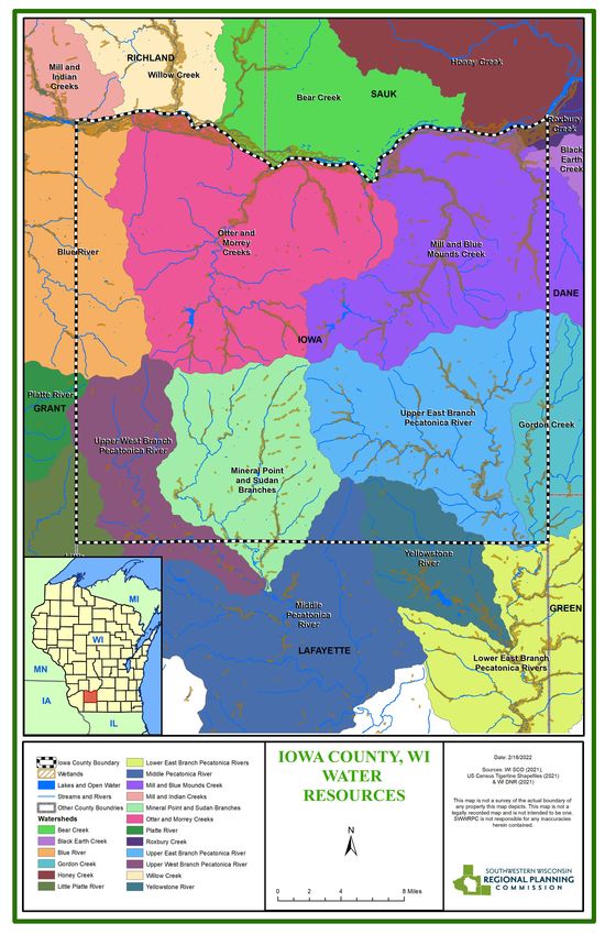
STAFF                   Table of Contents
         Troy Maggied
        Executive Director          Introduction ....................................................................... 4
           Kate Koziol
      Economic Development          Goals and Objectives ......................................................... 6
           Specialist
                                    Recommendations for Improving Recreation Facilities .... 7
        Matthew Honer
        Associate Planner           Plan Process ..................................................................... 10
          Griffin Koziol
        Associate Planner           Summary of State, Regional, & Local Planning Efforts .... 12
        Cory Ritterbusch
        Associate Planner           Description of the Planning Region ................................. 15
        Jaclyn Essandoh
      Planner/GIS Specialist        Standards for Park and Recreation Planning ................... 27
         Tasha Blindert             Outdoor Recreation Supply Inventory ............................. 29
         Office Manager
                                    Capital Improvements Schedule ...................................... 41
   COMMISSIONERS
        Grant County                Maintenance and Operations Schedule .......................... 42
        Robert Keeney*              Appendix A: NRPA Standards .......................................... 43
         Eileen Nickels
         Jerry Wehrle               Appendix B: Capital Improvement Schedule ................... 50
        Green County                Appendix C: Maintenance and Operations Schedule ...... 52
         Arthur Carter*
         Nathan Klassy              Appendix D: Maps ............................................................ 53
           Erica Roth
         Iowa County
          John Meyers*
           Todd Novak
         Carol Anderson
      Lafayette County
          Jack Sauer*
      Timothy McGettigan
       Raymond Spellman
       Richland County
        Marty Brewer*
         Melissa Luck
       Raymond Schmitz
   * denotes County Board Chair

            P.O. Box 262
       Platteville WI 53818
p: 608.342.1636 • f: 608.342.1220
       e: info@swwrpc.org
        www.swwrpc.org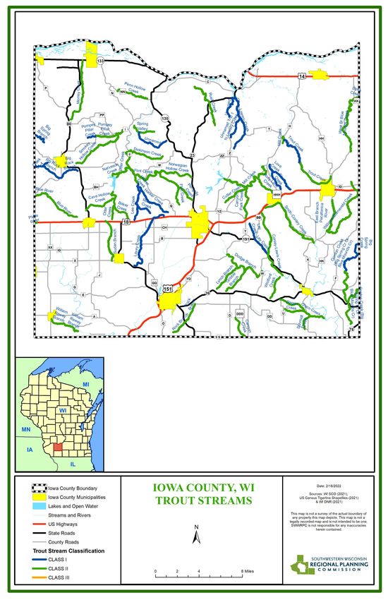
Introduction
The county, by virtue of this plan, has placed itself in a position of leadership among all providers of recreation in the
county. It’s most basic responsibility will be to lead a program that protects public and private investment, insures wise
use of natural resources, and provides its citizens and their guests with the most fulfilling recreation experiences possible.
As such, the county will serve as the coordinator and facilitator of partners and projects geared towards creating and
maintaining recreation opportunities in the county.
Iowa County is very conducive to outdoor recreation. It’s topography, low population density and location from populated
cities makes it a popular spot. The county also has a long tradition as a recreational area. However, Iowa County's role in
providing and promoting the development of outdoor recreational opportunities is varied because of its intermediate
position between federal, state, town and municipal governments. In addition, private enterprise which is becoming an
emerging market often provides recreation opportunities similar to those offered by the county.
This plan will consider the contributions of all providers of recreation, evaluate these contributions in relation to demands
for them, and develop recommendations for action to satisfy recreational deficiencies identified by this study. Both
quantity and quality of opportunities are considered and have direct bearing on decisions for specific recommendations.
The county will not be responsible for implementing all recommendations. Many, in fact, will be aimed at other units of
government and private enterprise.
Parks can serve a limited neighborhood area, the entire community, and the region as a whole. They provides outdoor
recreation for both residents and visitors. Open spaces are not limited to parks but also include greenbelts, wetlands,
scenic overlooks, and floodplains. Open space can also serve many functions for a community in addition to recreation,
such as:
Preservation of scenic and natural resources
Flood management
Protecting the area’s water resources
Preserving prime agricultural land
Limiting development that may occur
Buffering incompatible land uses
Structuring the community environment
Image 1: Governor Dodge State Park in Iowa County, WI
4 Comprehensive Outdoor Recreation Plan: Iowa County
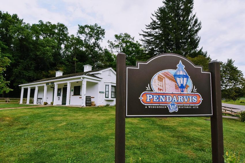
Plan Purpose
This plan is an update of the Iowa County’s Comprehensive Outdoor Recreation Plan (CORP) 1981 – 1986. The purpose of
this plan is to guide the development and improvement of the county’s outdoor recreation facilities over the next five
years in order to meet the recreational needs and growing demands of the county.

Policy decisions made by the Iowa County Board of Supervisors for outdoor recreation programs and improvement shall
be guided by the goals, objectives, findings, and recommendations of this adopted plan. Actual public policy decisions or
choices are contingent on funding sources, new opportunities and ideas, changing growth patterns, budget priorities as
well as changing county needs and desires. For this reason, the plan should be reviewed annually, and a detailed update
such as this should be completed every five years. Updating the plan every five years is also a requirement of the Wisconsin
Department of Natural Resources (WIDNR) for a jurisdiction such as Iowa County to stay eligible for matching government
funds for parkland acquisition and facility improvements. But just as importantly, Iowa County needs to set a course of
action for continued improvement of its outdoor recreational system.

Image 2: The Pendarvis historic site located in Mineral Point, Iowa County, WI.

5    Comprehensive Outdoor Recreation Plan: Iowa County
Goals and Objectives
This plan is designed to provide a feasible program for meeting the recreational needs of Iowa County. Agreement upon
basic goals and objectives is necessary to set the general direction for developing this program. Four goals related to
recreational and resource protection are outlined below. The goals point toward final ends while the eight objective
statements are more directly related to achieving those ends through specific actions.
Goals
To preserve the county's open space resources and to protect them from visual blight and degradation of
quality.
To provide quality parks and recreational facilities to meet the needs of county residents.
To provide opportunities for nonresident recreational activity to an extent compatible with preserving
irreplaceable resources.
To identify and preserve sites having scientific, historic, or archaeological significance.
Objectives
To use multiple approaches to resource protection, including acquisition and easements through partnerships
with other entities when appropriate.
To combine resource protection with park and recreation development, where feasible, through multi-purpose
projects.
To coordinate the county's recreation program with the programs of other levels of government and with
private enterprise in order to achieve maximum public benefit.
To provide areas and facilities for those activities specified in the plan as a county responsibility.
To develop a coordinated system of river access points emphasizing resource-based recreation areas.
To maintain the quality of recreational experiences offered within the county by adhering to the standards
contained in the plan.
To encourage quality development of privately owned recreation facilities, particularly for nonresident-oriented
activities.
To maintain the county's eligibility to participate in federal and state financial and technical aid programs having
recreation planning requirements.
6 Comprehensive Outdoor Recreation Plan: Iowa County
Image 3: Avoca Lake within the Village of Avoca, Iowa County, WI
Recommendations for Improving Recreation Facilities
The following recommendations for improvement by the Iowa County Land Conservation Committee follow the
proposed Capital Improvement Plan (Appendix B). These recommendations will be completed based on availability of
county funding and grants.
Bloomfield Prairie property:
Several improvements are needed on the Bloomfield Prairie property. Recommendations for individual projects or
activities are listed below:
1. Pond area:
Dredge (or start with feasibility study for dredging)
Weed/algae control
Install canoe launch
Build longer accessible pier (to reach deeper water/fewer weeds)
Brush/weed control around the edge
Rework trail and repair/rebuild footbridge just north of the Pond
Possibly expand shelter (or maintain/repair as needed)
Add pit toilet
Add electricity (or solar panels) to the pond shelter so users could have light.
2. Non-CRP/CREP areas:
Create accessible trails
Create bike-able trails
Create interpretive signs
Add footbridges in pasture for public access to eastern fields
Upgrade/replace other bridges (3)
New or updated kiosks
Create off-leash dog area
7 Comprehensive Outdoor Recreation Plan: Iowa County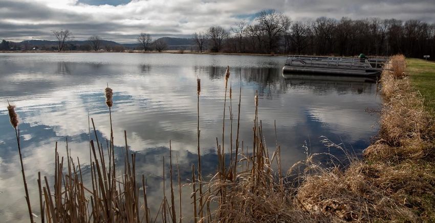
Improve existing and add additional parking areas
3. Red shed:
Add pit toilet/bathroom
Preserve red barn; modify to a shelter or meeting facility
Add electricity (or solar panels) to the red shed
4. White shed:
Add a cement floor and more garage doors to the white shed.
5. General:
Increased management of invasive brush and herbaceous invasive weeds, including but not limited to wild
parsnip, Canada thistle, crown vetch, and bush honeysuckle.
Blackhawk Lake Recreation Area:
Several improvements are needed on the Blackhawk Lake Recreation Area. Recommendations for individual projects or
activities are listed below:
1. Pit toilet repairs/Remodel
2. Weed/Algae control in beach swimming area
3. Roof replacement on pavilions
4. Retaining wall at beach area
5. Cabin repairs/Rebuilds
6. Parking lot maintenance
7. Shower house repairs and remodels
8. Nature Center improvements/Taxidermy
9. New playground equipment
10. Walk bridge replacement on hiking trail
Military Ridge State Trail:
Several improvements are needed on the Military Ridge State Trail. Recommendations for individual projects or
activities are listed below:
1. Increase trail repair/ maintenance on Military Ridge State Trail.
2. Provide dog waste station along trail.
3. Provide bore benches along trail for walking people to sit.
4. Provide more trash cans along trail.
Additional recreation needs/recommendations:
1. The County owns some properties in the Mifflin area along the Pecatonica River and CTH E; which could be
made into a park if there is interest to do so, otherwise should consider selling.
8 Comprehensive Outdoor Recreation Plan: Iowa County
2. There is some additional right of way also owned by the county at Factory road and CTH II which could be an
access point for fishing easements or a park along Otter Creek.
3. The County and the DNR should continue to work on a cooperative basis to enhance recreational opportunities
in the State Riverway and on other public lands for residents of the County. This effort should include on a
regional level, integrating a future planned Wisconsin DNR trail along the lower Wisconsin River between
Muscoda and Avoca. The proposed trail could link the recreational park and boat launches in Avoca as well as
that in Muscoda. Both of these facilities have been constructed in the past two years. This would greatly
enhance the recreational opportunities for both of these communities and increase tourism and economic
development for this region. Additional recreation needs to be implemented within Pulaski township include:
Trail to the Avoca Prairie, possibly some interpretive trail, with signs talking about its unique
ecosystem/flora/fauna.
Improving/fixing the bridge to cross the river/creek to get out to the Avoca Prairie.
Trail/loop in the Avoca prairie.
Improvement/building out sand for their beach on the Wisconsin River in Avoca.
Life jacket library for the beach.
A canoe/kayak launch or some canoe/kayak access on the Wisconsin River.
4. Continue to provide and enhance public access to the Lower Wisconsin Riverway.
5. Continue to upgrade the parks and recreational areas the county owns or manages by bringing all facilities up to
ADA standards over the next five to ten years.
6. Consider including paved shoulders as part of future road reconstruction projects to allow safer passing of
slower moving vehicles which would benefit ATV/UTV, bicycle, and farm implement traffic.
7. Use the University of Wisconsin Platteville engineering students for any future park project(s). SWWRPC should
help guide the process in pairing Iowa County with a suitable team.
8. Explore the feasibility of a trap shooting facility. If feasible, develop a location and facility for youth clubs and
school-based teams.
9. Assess the current needs and opportunities for kayaking and canoeing, and, if feasible, develop additional
kayak/canoe facilities.
10. The Land Conservation Committee should review the plan at least once a year to assess progress.
9 Comprehensive Outdoor Recreation Plan: Iowa County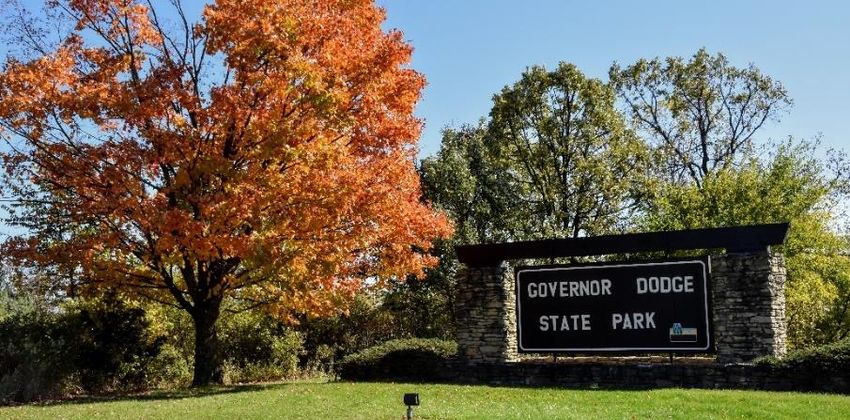
Plan Process
This section of the report gives a brief description of the sequences of events that took place during the development of
the Comprehensive Outdoor Recreation Plan (CORP). It also describes the process that can be used to amend the plan.

Description of Process
Iowa County has had an Outdoor Recreation Plan since 1971. However, there is always a need to evaluate progress and
update the plan to meet the future goals for recreation in this county. Therefore, the Iowa County Land Conservation
Department (the agency currently responsible for park and recreational development in Iowa County) met to discuss what
had been done since the last plan. After the Committee understood what had been accomplished in the past, they looked
to the future. Results from the Iowa County Land Conservation Committee meeting were shared with the Iowa County
Highway Department (the department responsible for maintaining some of the park and recreational amenities in Iowa
County). Feedback from the Iowa County Highway Department were compiled and added to the project recommendations
proposed by the Iowa County Land Conservation Committee. Additional public comments which have also been included
in the plan were received from members of the public via email. A complete list of recommendations can be found on
pages 7-9 of this plan.

The Committee with assistance from the Southwest Wisconsin Regional Planning Commission (SWWRPC) then developed
a preliminary draft of the updated Comprehensive Outdoor Recreation Plan, based on the recommendation of the
Committee, the Highway Department, and the general public.

The updated report was reproduced in draft form and copies given to members of the Land Conservation Committee for
their review and comment. After suggesting any minor revisions to the planning document, the Land Conservation
Committee were then asked to endorse the draft Comprehensive Outdoor Recreation Plan as their guide for
future decisions related to park development in Iowa County. The Land Conservation Committee then submited an
updated report to the Public Works Committee for consideration and approval. The Land Conservation Committee
reviewed a proposed resolution to be taken to the Iowa County Board of Supervisors regarding adoption of the planning
document. Following this meeting the Land Conservation Committee produced the final report and provided
copies to all County Board members for their review and comments. The County Board was also given a copy
of the proposed resolution recommending adoption of the plan as the county’s official park and recreation plan for
the next five year period. Upon adoption, the plan was submitted to the Wisconsin Department of Natural
Resources requesting re-certification for participation in the state’s park and recreation cost sharing programs.

Amending the Plan
Plan amendments are common and should be considered part of the planning process. They frequently represent good
implementation or plan usage and should be acceptable for consideration by local decision makers. Amendments must
follow the same process as when the original plan was prepared. Amendments generally prolong the effectiveness of the
original plan.

The following steps will ensure any new amendment is approved with respect to state statues and to the citizens of Iowa
County:
     1. Initial meetings/framing the amendment: Depending on the size and scope of the amendment, the Land
        Conservation Committee will meet several times to discuss the proposed amendment.

10    Comprehensive Outdoor Recreation Plan: Iowa County
2. Opportunity for Public Input: A public forum should be provided with ample time for the community to know
about the proposed changes to the plan. Then a public meeting should be held so the community can understand
the need for amendment and have an opportunity to provide direct feedback on the proposed changes.
3. Draft Amendment: The Land Conservation Committee develop a draft amendment that still captures the need for
the amendment and feedback from the public.
4. Amendment Adoption: At an official public meeting, the County Board will vote to approve the plan amendment
with the recommendation of the Land Conservation Committee.
5. WIDNR Approval: The board action on the plan amendment should be sent in writing to the WIDNR for re-
certification of the county’s Comprehensive Outdoor Recreation Plan with the new changes. The plan amendment
will not be effective until a letter is received from DNR indicating their approval.
Image 4: Blackhawk Lake Recreation Area in Iowa County, WI
11 Comprehensive Outdoor Recreation Plan: Iowa CountySummary of State, Regional and Local Planning Efforts
Image 4: View of the Wisconsin River in Iowa County, WI
Statewide Comprehensive Outdoor Recreation Plan
“Our effectiveness in meeting future recreation needs will be shaped by many factors including the shifting demographics of our population, the
quality of habitats and the impacts from invasive species and changing climate conditions, our ability to improve the compatibility between and
among recreation participants, and sustainable financial resources. Parks and nature preserves, wildlife areas and refuges, and forests and trails
connect people to the natural environment. These places, from small neighborhood parks to the large national, state and county forests, are the
stages on which we enjoy the outdoors, improve our health, protect our air and water, and provide a large economic boost, particularly to our
rural areas. – Wisconsin Statewide Outdoor Recreation Plan
The 2019-2023 Wisconsin Statewide Comprehensive Outdoor Recreation Plan (SCORP), provides recommendations to
guide public outdoor recreation policy, planning decisions, the use of Land and Water Conservation Fund money, and
other WIDNR administered Iowa programs.
High-quality outdoor recreation experiences available in Wisconsin contribute to our exceptional quality of life; reflected
in sustained economic growth and in outdoor recreation traditions passed down through generations. From community
river walks to expansive public forests, public recreation lands and facilities enhance our lives, draw millions of visitors,
and support businesses large and small. The economic, social, and health benefits of outdoor recreation in Wisconsin far
outweigh the investment.
To support the development of SCORP, a statewide survey of Wisconsin residents was conducted regarding outdoor
recreation participation and frequency, as well as opinions about future needs. In addition, WIDNR undertook an
assessment of recreation opportunities and needs in each region of the state. Together, these supporting documents show
that an estimated 95% of Wisconsin adults participated in some type of outdoor recreation in the past year. Activities in
which residents most frequently engaged tend to be those that require little preparation or travel time and can provide a
12 Comprehensive Outdoor Recreation Plan: Iowa Countyhigh-quality experience in a limited amount of time. Examples include hiking and walking on trails, fishing, bicycling, dog
walking, and bird/wildlife watching.
SCORP goals include:
Boost participation in outdoor recreation.
Grow partnerships.
Provide high-quality experiences.
Improve data to enhance visitor experiences and benefits.
Enhance funding and financial stability.
Additionally, the SCORP highlights regional recreational demands that supports Iowa County’s priorities for its location in
the Southern Gateways Region. The top ten (10) most frequently identified recreation opportunities, needed in the
Southern Gateways Region, based on public input gathered during the SCORP Recreation Opportunities Analysis (ROA)
process include:
More trails for motorized recreation (ATVs, UTVs, off-road motorcycles, etc.)
More hiking/walking/running trails
More natural surface (dirt) bicycling trails
More paved bicycling trails
More rustic/quiet campgrounds (pit toilets, no electricity or generators)
More public shore access to lakes & streams
More developed campgrounds (electric hook-ups, flush toilets, showers)
More local parks and playgrounds
More horse trails
More public shooting ranges
Regional Planning Efforts
In 2010, SWWRPC initiated a regional visioning and planning project titled “Grow Southwest Wisconsin” as part of the
Sustainable Communities program of the U.S. Departments of Housing and Urban Development, Transportation, and
Environmental Protection Agency. Goal 3 of the Culture and Creativity element is to “Attract people from outside
Southwestern Wisconsin through regional branding and marketing,” with Strategy 3.5.2 recommending that the region’s
leaders “Connect the marketing of arts and culture opportunities with recreational trails such as bike and ATV.” Goal 2 of
the Transportation element also recognizes the importance of prioritizing safety in all tranportation projects with Strategy
2.2.1 recommending the needs of all users in road construction projects. Strategy 2.2.3 of the same goal also recommends
adhering to or exceeding the Americans with Disabilities Act standards.
Summary of Previous Outdoor Recreation Plan
Iowa County’s previous Comprehensive Outdoor Recreation Plan was completed in 1981 by the Iowa County Board of
Supervisors, with technical assistance from the Southwestern Wisconsin Regional Planning Commission. The plan was
prepared with the intent of guiding the future recreation programs of the county and the communities located within it.
The plan was divided into two parts--the county plan and the community plans for Dodgeville, Mineral Point, Arena, Avoca,
Barneveld, Cobb, Highland, Hollandale, Linden, Rewey, and Ridgeway. Consideration of park facilities and needs of smaller
unincorporated Iowa County communities were covered under the county portion of the plan. The most significant
13 Comprehensive Outdoor Recreation Plan: Iowa Countyrecommendation in the 1981 plan which has since been implemented is the Military Ridge State Trail. The 40-mile Military Ridge State Trail, in Iowa and Dane counties, connects Dodgeville and Madison by way of an 1855 military route between Verona and Dodgeville. The trail runs along the southern borders of Governor Dodge and Blue Mound state parks passing by agricultural lands, woods, wetlands and prairies, and provides a public trail opportunity for biking, hiking, and snowmobiling. 14 Comprehensive Outdoor Recreation Plan: Iowa County
Description of the Planning Region
Social characteristics of Iowa County
According to the 2020 Census, the population of the Iowa County is 23,709, which is up 22 persons from the 2010 US
Census count. Iowa County’s racial composition is largely homogenous; 94.2% of the County’s population being white.
The remaining 5.8% is split between the “Some Other Race” “Asian”, and “Black or African American” categories. Iowa
County’s lack of racial diversity is standard for the southwestern Wisconsin region, and lags behind the state average,
with 80.4% white and a 19.6% split of other races, black being the highest at 6%.

Iowa County maintains a median age of 42.8, similar to many communities in southwestern Wisconsin. Table 2
illustrates that roughly 57% of the community is between 20 and 64 years old. This wide working-age base helps ground
the community economically and provides stability. Unlike most surrounding counties, Iowa County has a sufficient
youth population to have population growth projected out to 2035.
Table 1: Iowa County Age Cohorts

                         Total Population Total Male      Total Female
 Total Population        23618      100% 11865 50.24%       11753 49.76%
 Under 5 years            1343      5.7%    686      5.8%      657     5.6%        5,877 Total   24.9%
 5 to 9 years             1543      6.5%    765      6.4%      778     6.6%        "youth"       of total
 10 to 14 years           1583      6.7%    817      6.9%      766     6.5%        population    population
 15 to 19 years           1408         6%   748      6.3%      660     5.6%
 20 to 24 years           1144      4.8%    596        5%      548     4.7%        13,487        57.1%
 25 to 29 years           1238      5.2%    599        5%      639     5.4%        Total         of total
 30 to 34 years           1368      5.8%    698      5.9%      670     5.7%        working-      population
 35 to 39 years           1500      6.4%    789      6.6%      711       6%        age
 40 to 44 years           1227      5.2%    613      5.2%      614     5.2%        population
 45 to 49 years           1453      6.2%    740      6.2%      713     6.1%
 50 to 54 years           1817      7.7%    884      7.5%      933     7.9%
 55 to 59 years           2003      8.5%    985      8.3%    1018      8.7%
 60 to 64 years           1737      7.4%    910      7.7%      827       7%
 65 to 69 years           1533      6.5%    789      6.6%      744     6.3%     4,254 Total      18%
 70 to 74 years           1053      4.5%    523      4.4%      530     4.5%     retired-age      of total
 75 to 79 years        693      2.9%        347      2.9%        346       2.9% population       population
 80 to 84 years        463        2%        198      1.7%        265       2.3%
 85 years and over     512      2.2%        178      1.5%        334       2.8%
 Source: US Census 2019 Estimates

Figure 1 is a population pyramid that shows a snapshot of Iowa’s population taken from the 2019 US Census Estimates.
As mentioned previously, the largest portion of the pyramid is the “working-age” population between 20 and 64 years.
The middle of the pyramid is bloated and the top and bottom are narrow. This means that while the County’s population
is currently stable, in the future it will decline, unless more residents move into the County.

15    Comprehensive Outdoor Recreation Plan: Iowa County
Figure 1: Iowa County Population Pyramid
Iowa County Population Age Cohort
80 to 84
70 to 74
60 to 64
50 to 54
40 to 44
30 to 34
20 to 24
10 to 14
Under 5
-1500 -1000 -500 0 500 1000 1500
Source: US Census 2019 Estimates
Male Female
These findings are consistent with information from the Wisconsin Department of Administration (DOA), which is believed
to provide a more accurate reflection of population growth estimates. The Wisconsin DOA estimates are based on the
2010 Census and analysis of contemporary data including housing units, dormitory and institutional populations,
automobile registrations, and other indicators of population change. According to the DOA, Iowa County’s population will
increase slightly from 2010 to 2035, but as the large “working-age” population advances in age, there will not be enough
of a youth population to support their loss and the community will lose residents from 2035 to 2040. Figure 3 illustrates
the potential rise and decline thereafter in population.
Figure 2: Iowa Population Projection
Iowa County Population Projection
28,000 27,390
27,105 26,990
27,000 26,150
26,000
Population
25,000
23,687 23,709
24,000
23,000
22,000
21,000
2010 Census 2020 Census 2025 Proj. 2030 Proj. 2035 Proj. 2040 Proj.
Year Source: Wisconsin Department of Administration
US Census Bureau
16 Comprehensive Outdoor Recreation Plan: Iowa CountyEconomy
Within Iowa County, the local economy is driven by businesses within the “Educational services, and health care and
social assistance”, “Retail trade”, and “Manufacturing” industries. The Iowa County has an estimated 2.8%
unemployment rate according to the 2019 US Census estimates and approximately 8.8% of people at or below the
poverty level. The median household income for people living within the County is $64,124 according to the 2019 US
Census estimates.
Physical Characteristics of Iowa County
Location
Iowa County is located in the southwestern part of the state bounded on the north by the Wisconsin River (beyond which
are Richland and Sauk Counties), on the east and southeast by Dane and Green Counties, on the west by Grant County,
and on the south by Lafayette County.
Figure 3 shows some recreational opportunities in Iowa County. The county is well-positioned to provide residents with a
variety of recreation activities, including Bloomfield Prairie, Governor Dodge State Park, Blackhawk Lake Recreational
Area, Birch Lake Park, Tower Hill State Park, Blue Mounds State Park, among others. Within 50 miles, residents can utilize
Yellowstone Lake State Park, Wyalusing State Park, Nelson Dewey State Park, O’Leary’s Lake Recreational Area, Snow
Bottom State Natural Area, and more. Many also utilize the numerous smaller rivers and streams. This makes outdoor
recreation a large part of the local economy. The locations of all public access lands and state parks in Iowa County can be
found at the following websites:
Wisconsin’s Public Access Lands Web Map:
https://dnrmaps.wi.gov/H5/?Viewer=Public_Access_Lands
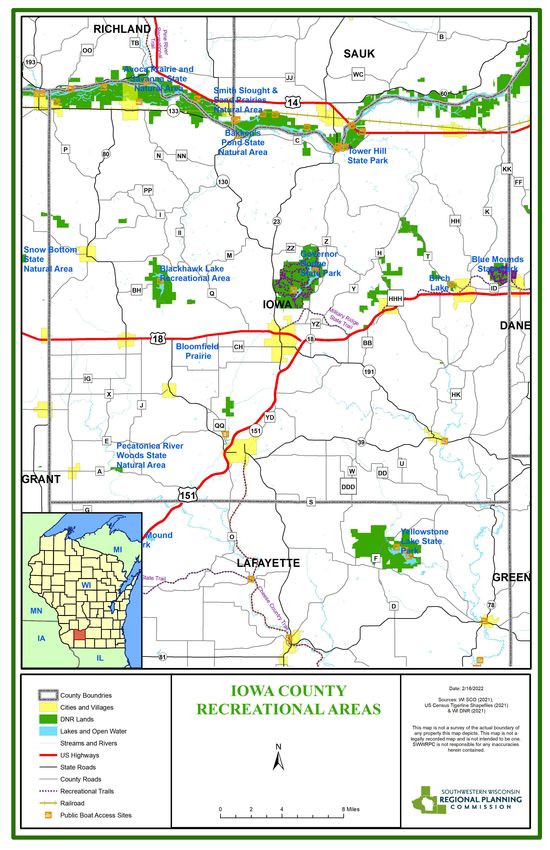
17 Comprehensive Outdoor Recreation Plan: Iowa CountyFigure 3: Recreation Opportunities in Iowa County 18 Comprehensive Outdoor Recreation Plan: Iowa County
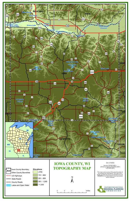
Topography
Iowa County is located entirely within the Western Upland. The Western Upland is a geographical region covering much
of the western half of Wisconsin. It stretches from southern Polk County in the north to the state border with Illinois in
the south, and from Rock County in the east to the Mississippi River in the west. Wisconsin's Western Upland is a rugged,
hilly region deeply dissected by rivers and streams. The area is characterized by rocky outcroppings and numerous small
caves, as well as sharp and frequent changes in altitude. The average elevation in the region is between 900 to 1,200 feet
above sea level, where the area immediately adjacent to the highland averages 600 to 900 feet in elevation. Aside from
the Upland itself, the strongest topographic features of the region are the trenches of the Mississippi and Wisconsin Rivers
and their numerous branches. One of the most dominant topographic features of the region is Military Ridge. The Ridge
is the divide between the north flowing tributaries of the Wisconsin River and the south flowing tributaries to the Rock
and Mississippi Rivers. It has also been important to the region’s history.

The entire region, with the exception of the eastern half of Green County and a small portion of southeast Lafayette
County, is characterized by rugged, steep-walled valleys and high relief. The region is referred to as the Driftless Area
which preserves a large sample of what the rest of Wisconsin, as well as the northern and eastern United States were like
before the Glacial Period.

Figure 4 is a topographic map for Iowa County, a prime example of the topography of the Driftless Region.

19   Comprehensive Outdoor Recreation Plan: Iowa County
Figure 4: Iowa County Topographic Features

20    Comprehensive Outdoor Recreation Plan: Iowa County
Climate
Iowa County’s climate is continental and typical of the central areas of a continent in the middle latitudes. Winters are
relatively cold and snowy with extended periods of rain during the spring and autumn and intermittent periods of hot
humid summer weather. Air temperatures within the county are subject to large seasonal change and yearly variations.
Precipitation in the county for the six-month period from April through September may range in intensity and duration
from showers to destructive thunderstorms. The snow fall average for Iowa County is about 40 inches annually which has
risen in the past few decades. Prevailing winds are westerly in winter and southerly in summer.

Soils
The soils of Iowa County can be characterized as generally being underlain by dolomite (limestone) or sandstone bedrock
with a mantle of loess (silty, wind-blown material) ranging from 1 to more than 10 feet in thickness. The soils of the upland
ridges formed partly in this loess and partly in materials weathered from the underlying bedrock. On the lowest stream
terraces along the Wisconsin River, sandy glacial outwash is exposed. This is parent material of the Plainfield and Sparta
soils.

Flora and Fauna
Iowa County includes both the “Southwest Savanna” and “Western Coulee and Ridges” ecological landscapes in Wisconsin.
Both landscapes were once dominated by fire-dependent natural communities of Prairie, Oak Savanna, Oak Woodland
and Oak Forest. They are now predominately dominated by agriculture, however, remnants of the former natural
communities do exist but typically in small low-quality pieces. Three-percent of the land in the Western Coulee and Ridges
eco-region are in public ownership so care for the public lands are important. The Western Coulee and Ridges eco-region
also includes high quality streams. On the other hand, less than one-percent of the land in the Southwest Savanna eco-
region are in public ownership. The WIDNR believes the Southwest Savanna landscape offers the best opportunity in the
state for large scale grassland management and restoration. The Southwest Savanna ecosystem also has high quality
streams, and so making buffer zones adjacent to them is very important.

Threats from invasive plant species have been increasing and control of them should be considered in both ecosystems.
Invasive plants reduce opportunities for recreation, increase chances for erosion, decrease habitat, and lessen the
aesthetics of areas. Some of these invasive plants include: Garlic mustard (Alliaria petiolate), Spotted knapweed
(Centaurea stoebe), Canada thistle (Cirsium arvense), Crown vetch (Coronilla varia), Common teasel (Dipsacus sylvestris),
Autumn olive (Elaeagnus umbellata), Burning bush (Euonymus alatus), Dame's rocket (Hesperis matronalis), Tartarian
honeysuckle (Lonicera tatarica), Purple loosestrife (Lythrum salicaria), White mulberry (Morus alba), Wild parsnip
(Pastinaca sativa), Reed canary grass (Phalaris arundinacea), Black locust (Robinia pseudoacacia), Multiflora rose (Rosa
multiflora). Any plant that is dominating an area could be considered as invasive.

Common trees of the area historically would include fire tolerant Oaks, Shagbark Hickory and Hazelnut undergrowth. In
ravines and near waterways would have been Maple, Basswood dominated. However, due to mesophication, woodlands
are becoming dominated by other low-quality tree species.
Both landscapes contain public lands which provide abundant recreation opportunities with some of the most popular
being surface trail bicycling, paddle sports, fishing and hiking, and walking or running on trails. The cold and cool water
streams are also vital to recreation opportunities and their protection and enhancement should be imperative to any land
use decision. Warm water streams with small mouth bass populations should also be prioritized.

21   Comprehensive Outdoor Recreation Plan: Iowa County
Water Resources
In general, the county is divided into two drainage areas by the Military Ridge, which runs east and west across the middle
of the county. North of the ridge surface waters drain into the Wisconsin River. The main streams of this north- flowing
system are the Blue River and Morrey, Otter, Sneed, Lowery, Rush, Mill, and Blue Mounds Creeks.

Almost all of the surface waters south of the ridge drain in a southeasterly direction into the east and west branches of
the Pecatonica River. Some tributaries of the Platte River also have their beginnings in Iowa County and flow southwesterly
toward the Mississippi River.

Since Iowa County lies wholly within the Driftless Area, there are few natural lakes. Oxbows and meander scrolls in the
floodplain of the Wisconsin River and man-made impoundments comprise all of the lakes in the county (including
Blackhawk Lake opened in 1972).

The surface water features of Iowa County total 7,093 acres, excluding farm ponds, and comprise 1.4% of the county area.
Perennial streams account for 6,500 acres and lakes and sloughs comprise 592 acres. The Wisconsin River, which forms
the northern border of the county, has about 5,600 acres of the total. The total stream length is 600 miles including 76
miles of the Wisconsin River. The lakes range in size from 6.4 acres to the 220 acre impoundment of Blackhawk Lake which
has, to date, exhibited excellent water quality.

The county has an abundant supply of underground water. All of the geological formations underlying the soils contain
water, the main source being the Upper Cambrian sandstone. Springs are numerous and furnish cold, clear water with a
high mineral content. The springs support a good trout fishery in the upper reaches of many of the streams.

Wetlands in Iowa County include all marshes and swamps and those areas which are excluded from cultivation or other
use because they are intermittently wet. Most wetland areas are subject to periodic flooding. The most extensive and
productive wetlands for wildlife are located in the bottom lands bordering the Wisconsin River. The values of wetlands
are many. In addition to providing filtration of pollutants from surface water and providing flood water storage capacity,
the wetlands and the transitional areas between wetland and upland provide habitat for many wildlife species. Although
there is only a relatively small wetland area in Iowa County, it is a resource which is much sought after for recreational
purposes.

22   Comprehensive Outdoor Recreation Plan: Iowa County
Figure 5: Iowa County’s Water Resources

23    Comprehensive Outdoor Recreation Plan: Iowa County
Fish and Game
Numerous species of fish are found in Iowa County streams and lakes. Sport fish include largemouth and smallmouth bass,
northern pike, walleye, catfish, white sucker, and several species of trout.

Rainbow, brook, and brown trout are abundant in Iowa County trout streams shown on Figure 6. There are 49 trout
streams stretching a total distance of 254 miles in Iowa County. The majority of these stream miles have been designated
Class II, or streams that have native trout but require moderate to heavy stocking for high quality fishing opportunities.
Class I streams indicates that conditions are favorable for natural reproduction and that little or no stocking of hatchery
fish is required. Usually these streams are of short length and have small trout, especially in their headwaters. Class III
streams are marginal trout habitat and require extensive stocking of legal trout to sustain fishing opportunities.

Topography plays an important role in determining the amount and distribution of wildlife in Iowa County, For instance,
water fowl are the most abundant along the Wisconsin River and its attendant sloughs and marshes. Land use in northern
Iowa County has become more recreationally oriented while the influence of agriculture in the area has declined. As
grasslands and bush as well as woodlands have become more common, the wildlife population has expanded. White-
tailed deer, for example, have made substantial increases in the size of the herd. Substantial populations of ruffed grouse
and squirrel are also located in the northern part of the county. Southern Iowa County contains habitat areas for pheasant,
squirrel, and Hungarian partridge.

Further discussions of fish and game and their relationship to recreational activities are contained in later sections of this
plan.

24   Comprehensive Outdoor Recreation Plan: Iowa County
Figure 6: Iowa County’s Trout Streams

25    Comprehensive Outdoor Recreation Plan: Iowa County
Land Use
The amount of land specifically devoted to recreational purposes is minor in relationship to the total land area of Iowa
County. However, it is recognized that a considerable amount of farm acreage is used for extensive forms of recreation,
like hunting, hiking, nature study, and snowmobiling. These activities seldom require elaborate recreation facilities or a
financial investment of consequence.

Agriculture has long been the major land use and principle industry in Iowa County. About 70% of the county's total land
area is used for agriculture and open land. Nearly all of the forest land in the county is in private, farm ownership and,
therefore, has been assigned to agricultural use. Forestry has a positive impact on recreation. Forests complement
numerous outdoor recreation activities, like sightseeing, nature study, and hunting, and provide visual variety to the
agricultural landscape. They also protect the soils and water supplies of the county. While there are many important oak
dominated woodlands in the north, there are also significant prairies, savannas, and grasslands particularly in the south
of the county. Within many of these grass-dominated habitats there are many critical habitats for endangered or declining
insects and birds. For example, the Mounds View Grassland north of Hollandale is a remnant prairie serving as vital habitat
for the Wisconsin-endangered Regal Fritillary Butterfly as well as declining grassland birds such as the Dickcissel, Upland
Sandpiper and Bell’s Vireo.

The Department of Natural Resources (DNR) owns and manages approximately 21,609 acres of recreational land within
Iowa County including a great deal of land located along the Lower Wisconsin State Riverway. There is also a significant
amount of land open to the public for recreation that is owned and managed by non-profit organizations such as the
Driftless Area Land Conservancy, The Prairie Enthusiasts, and The Nature Conservancy.

Recent population trends and the influx of new business into Iowa County are expected to reduce the amount of land
dedicated to agrarian and forestry purposes and to recreation in general. Land lost to growth may be less than significant
quantitatively. Nevertheless, growth must be controlled because of its cumulative effects and because it may occur on
properties best suited to other purposes.

26   Comprehensive Outdoor Recreation Plan: Iowa County
Standards for Park and Recreation Planning
The standards system is a method of assessing an area’s outdoor recreation needs. The National Recreation and Park
Association developed standards to provide a scale against which the existing recreation system can be measured.
Standards can be used to create guidelines for future needs. Typically, standards link park acreage to the area’s
population, or link the number of recreation facilities to the population. In addition, service area standards are also used
to determine recreational needs.
Recreation Open Space Standards
The National Recreation and Park Association (NRPA) has endorsed a park and open space classification system which will
serve as a guide throughout much of this plan. These standards pertain only to parks, recreation lands, and other open
spaces discussed in this plan. Standards can be a good starting point or reference when determining a county’s outdoor
recreation land and facility needs. However, each county’s needs are different based on such factors as the county’s
demographic profile and what types of facilities and outdoor recreation priorities the citizenry deem important. Resident
input in the form of surveys and/or public hearings are also important when recreation and park planners look at future
development and/or preservation of public lands.
NRPA’s standards have been modified to more accurately define park, recreation land and open spaces within Iowa
County. For example, NRPA recommends that a County Park have a desirable size of 15+ acres. In Iowa County, most
parks of this nature are in the 5 to 100+ acres range. This has been noted in the definition section below. All parks,
recreation lands and open space under the jurisdiction of Iowa County have been assigned one primary classification or
code using the following titles and abbreviations: (CP) County Park; (LP) Linear Park; (SU) Special Use Area.
CP: County Park
o Desirable/Typical Size: 5 to 100+ acres
o Service Area: 1 – 15 miles.
o Acres/1,000 Population: Variable.
o Use: Area of diverse environmental quality. This may be an area of natural quality for outdoor recreation
such as walking, viewing, sitting or picnicking. It may be any combination of the above depending upon
site suitability and community need.
o Site Characteristics: May include natural features, such as water bodies and areas suited for intense
development. The site has easy access by all modes of transportation.
SU: Special Use Area
o Desirable/Typical Size: Variable depending on type of facility.
o Service Area: Entire County, or part of the county.
o Acres/1,000 Population: Variable.
o Use: Areas for specialized or single purpose recreational activities such as golf courses, nature centers,
marinas, zoos, conservancies, arboreta, display gardens, arenas, outdoor theaters, gun ranges, and
downhill ski areas. Also includes plazas or squares in or near commercial centers, boulevards, or parkways.
o Site Characteristics: Located within the county.
LP: Linear Park
o Desirable/Typical Size: Sufficient width to protect resources and to provide maximum use.
o Service Area: No applicable standard.
o Acres/1,000 Population: Variable.
27 Comprehensive Outdoor Recreation Plan: Iowa Countyo Use: Area developed for one or more varying modes of recreational travel or activity such as hiking, biking,
snowmobiling, horseback riding, fitness trails/skiing and canoeing. May include active play areas.
o Site Characteristics: Built on natural corridors such as utility or railroad right-of-way, bluff lines, vegetation
patterns, and roads that link other components of the recreation system or community facilities such as
school, libraries, commercial areas, and other park areas.
Recreational Facility Development Standards
Standards for the development of recreation facilities, similar to open space standards are expressed in facility units per
population ratio. The purpose of evaluating a recreation system is to determine the amount of needed facilities in each
recreation area.
Recreation facility development standards serve as an excellent resource guide when local officials are developing a new
park or are upgrading an existing recreation area. These standards provide recommendations regarding space
requirements for various recreation activities. They also provide recommendations regarding size and dimensions for
each activity, the best orientation to avoid sunlight in the eyes, a recommended service radius for each activity, and other
criteria to be considered when locating a recreation facility/activity.
Age, income and education all contribute to people’s recreational preferences, yet facility standards sometimes ignore
these variables. Another problem with using standards is that they have been developed primarily for urban communities
and have limited application to rural areas. Despite these problems, facility development standards have a place in
recreation planning. County leaders use them to approximate the adequacy of their parks systems.
A listing of the NRPA’s park and open space standards and suggested facility development standards can be found in
Appendix A of this report. Included in the listing of recreation facility development standards are such activities as baseball,
softball, football, field hockey, soccer, volleyball, tennis, badminton, ice hockey, archery range, golf-driving range, and
track running.
28 Comprehensive Outdoor Recreation Plan: Iowa CountyOutdoor Recreation Supply Inventory To determine what course of action county officials must take to provide comprehensive outdoor recreational opportunities, it is necessary to evaluate the supply of existing areas and facilities. This section of the report provides an inventory of Iowa County’s recreational facilities. Recreational opportunities in Iowa County are provided by the state, county, communities, and private enterprise. For ease of presentation, activities based on land resources are discussed separately from those based on water resources. Land-Based Activities Golfing There are three privately owned golf courses in Iowa County. The Dodge-Point Golf Course is a 18-hole facility located between the cities of Dodgeville and Mineral Point. The Springs Golf Course located south of Spring Green is an 27-hole championship course. The former facility primarily serves the resident population of south central Iowa County whereas the latter serves residents of northern Iowa County and southern Sauk County as well as a substantial number of tourists. Golf courses at Spring Green, New Glarus, and Mt. Horeb, while not located in Iowa County, do have service areas that extend into Iowa County and serve portions of the resident population. Pleasure Driving and Sightseeing Iowa County offers uniquely scenic landscapes for the traveling public. Northern Iowa County contains forested hills, spectacular rock formations, trout streams, and picturesque farms. The southern portion of the county is more agrarian in character with its beautiful pastoral scenes of well-maintained farms, woodlots, and rolling hills that are dissected by the area's stream network. Several wayside areas along major travel routes in Iowa County serve to enhance pleasure driving and sightseeing. Certain communities like the Village of Cobb have parks located adjacent to travel routes which also serve travelers. Skiing The rolling topography of Iowa County is excellently suited to skiing. However, the county lies below the snow belt which creates a problem in developing ski hills. Without snow making equipment, ski hills cannot operate on an economical basis in southern Wisconsin. There as historically been a ski resort in the county, but it is no longer in operation. Cross-country skiing, a sport rapidly gaining in popularity, should also be mentioned here. This activity requires neither hills nor deep snow. Only adequate space and light snow cover are necessary. Trails for cross-country skiing are located at Governor Dodge State Park, Blackhawk Lake, and Blue Mound State Park. Camping A summary of campgrounds is made in Table 2. More than one-half of the total camping units are located in the three state parks in the county. Governor Dodge State Park has the most campsites of any one campground with 269 units. The majority of the campsites are in public ownership, although one-third of the campgrounds are privately owned. Group or backpack campsites were not included in this inventory although it should be noted that several parks in the county do maintain facilities for, this type of camping. It also should be mentioned that certain businesses like motels, taverns, and gas stations allow overnight camping but these places as well were not included in the inventory. 29 Comprehensive Outdoor Recreation Plan: Iowa County
Table 2: Campground Inventory of Iowa County
           Name of Campground                                            Ownership
 Avoca Lakeside Park                     Village of Avoca
 Birch Lake Park                         Village of Barneveld
 Spring Valley Trails                    Private
 Hideaway Acres                          Private
 Toms Campground                         Private
 Blackhawk Lake Recreation Area          State of Wisconsin
 Governor Dodge State Park               State of Wisconsin
 Tower Hill State Park                   State of Wisconsin
 Blue Mound State Park                   State of Wisconsin

Hunting
There are 6,995 acres of land open to hunting by the public in Iowa County. Most of this acreage is found in five public
reserve areas--the Avoca Unit of the Wisconsin River Wildlife Area, the Blackhawk Lake Area, the Helena Marsh Wildlife
Area, Trout Creek and Love Creek. In addition, there are 112 acres- in the Hollandale Wildlife Area (see Table 3).

Table 3: Public Hunting Areas in Iowa County
                      Name of Area                                               Acreage
 Avoca Unit--Lower Wisconsin River Wildlife Area             3,873
 Blackhawk Lake Recreation Area                              1,495
 Helena Marsh Wildlife Area                                  636
 Trout Creek                                                 679
 Love Creek                                                  200
 Hollandale Wildlife Area (Pecatonica River Reserve)         112

The Avoca Unit is the largest of the six areas and, together with the Helena Marsh Area, is managed for hunting and wildlife
habitat using several techniques including food and cover plantings and prescribed burning. The area has good hunting
for deer, grouse, ducks, and pheasants as well as trapping. There is also good access for fishing. Both the State of Wisconsin
and Iowa County Land Conservation Department manage portions of Blackhawk Lake Recreation Area. The Department
of Natural Resources retains the right of fish and game management in all the tracts of land. This includes hunting as the
areas have been operated and managed as a public hunting reserve.

Love Creek and Trout Creek are primarily fish habitat areas along trout streams. Both are open to the public for hunting
and fishing and are managed by the WIDNR. In addition to the six public areas identified above, some private owners
permit hunting on their land, occasionally on a fee basis. However, this involves a relatively limited number of tracts of
land.

Picnicking
Picnicking supply is difficult to determine since a picnic table per se does not necessarily reflect the recreational
opportunity. Some highway waysides and municipal parks, for example, have picnic tables, but they were omitted from
the inventory because they are underutilized or because they lack the support facilities necessary for enjoyable picnicking.
Every local park that is mentioned has picnic tables, but the number fluctuates with the use or movement by need or other
reasons. The picnic areas considered to have an impact on outdoor recreation on a countywide basis are listed below.

30   Comprehensive Outdoor Recreation Plan: Iowa County
Nearly all of the picnic areas inventoried offer recreational opportunities in addition to picnicking. Table 4: Picnic Area Inventory of Iowa County Name of Area Ownership Soldiers Memorial Park City of Mineral Point Water Tower Park City of Mineral Point John Wilson Memorial Park City of Dodgeville Centennial Park City of Dodgeville Scheper Park Village of Cobb Village Park Village of Cobb Village Park Village of Linden Jonesdale Sportsman's Club Organizational Rewey Community Park Village of Rewey Wis. Power & Light Co. Park Private/Public Valley View Park Hollandale Birch Lake Park Village of Barneveld Village Park Village of Ridgeway Lakeside Park Village of Avoca Highland Park Village of Highland Highway Wayside (Arena) State of Wisconsin Highway Wayside (Dodgeville) State of Wisconsin Highway Wayside (Mineral Point) State of Wisconsin Highway Wayside (Mazomanie) State of Wisconsin Lost River Cave & Campground Private Blackhawk Lake Recreation Area State of Wisconsin Governor Dodge State Park State of Wisconsin Tower Hill State Park State of Wisconsin Blue Mound State Park State of Wisconsin Snowmobiling There are currently 120.3 miles of public trails eligible for state funding with an additional 54+ miles of club funded trails. All trails are maintained and groomed by volunteers with the clubs that are members of the Association of Iowa County Snowmobile Clubs, Inc. In addition, Iowa County has several privately owned or sponsored snowmobile areas including the Ski Timberline and Spring Valley Trails. Snowmobiling also takes place on right-of-ways of public highways but safety problems are involved with this. This recreational activity is also carried on over private lands with local snowmobile clubs owning or having been given permission to use some of these areas. Snowmobiling provides a tourism draw during an otherwise slow period. Figure 7 shows existing snowmobile trails in Iowa County. 31 Comprehensive Outdoor Recreation Plan: Iowa County
Figure 7: Snowmobile Trails in Iowa County

32    Comprehensive Outdoor Recreation Plan: Iowa County
ATV/UTV Routes
Figure 8 shows existing ATV/UTV routes in Iowa County which include approximately 936 miles of county, town, and
municipal roads open to ATV/UTV use. Proper signage and access to information is crucial to the expansion of this market.

Figure 8: ATV/UTV Trails in Iowa County

33    Comprehensive Outdoor Recreation Plan: Iowa County
Water-Based Activities

Fishing
The State of Wisconsin maintains overall responsibility for the management of fishery resources. The state, Iowa County,
and local units of government share the responsibility for providing public access to water resources and for the adoption
and enforcement of measures that serve to preserve the quality of our water resources.

There are 67 streams and 15 lakes in Iowa County with a combined water surface of 6,769 acres. The Wisconsin River
forms the northern boundary of the county. Public access points along the Wisconsin River, other streams, and lakes are
shown on Figure 3.

There are 49 listed trout streams in Iowa County, several of which have naturally reproducing trout. There are several
small mouth bass streams and panfishing occurs in a few lakes and farm ponds. Largemouth bass, walleyes, channel
catfish, white suckers, and northern pike are also found in certain Iowa County lakes and streams.

Inadequate public access points for those desiring to fish and pursue other water-related recreational activities is a small
problem. Poor water quality at certain locations is another problem that limits the quality of recreational experiences.

Canoeing and Boating
Few lakes in Iowa County are suitable for boating because of size limitations. The Wisconsin River and its backwater
lakes are the only bodies of water that are truly adequate for this type of recreational pursuit. Physically limiting factors
such as sandbars act to restrict recreational boating even on the Wisconsin River. Non-motorized boating is possible on
some of Iowa County's larger bodies of water like branches of the Pecatonica River, Cox Hollow and Twin Valley lakes in
Governor Dodge State Park, and on Blackhawk Lake.

Canoeing is possible on 44 miles of Iowa County streams including the East and West Branches of the Pecatonica River,
Mineral Paint Branch, Dodge Branch, Mill Creek, Otter Creek, and the Wisconsin River which stretches a distance of 34.8
miles along the northern Iowa County line. These streams are gentle and slow moving, being suitable for canoeists of all
ability levels. The natural resources of Iowa County can be viewed from a different perspective that most certainly
proves to be aesthetically pleasing for those persons making a canoe trip.

Swimming
Supervised swimming pools within the municipalities provide swimming opportunities in Iowa County. Public pools are
located in Dodgeville, Mineral Point, Muscoda, Montfort, and Blanchardville. In addition to the pools, there are public
beaches located within the county at the Avoca Lakeside Park, Birch Lake Park, Governor Dodge State Park, and Blackhawk
Lake Recreation Area. The total land area of beaches is 3.05 acres of which 1.8 acres are found at the two swimming
beaches in Governor Dodge State Park, 0.20 acres at the Avoca Lakeside Park, 0.30 acres at the Birch Lake Park, and 0.75
acres at the Blackhawk lake Recreation area. Iowa County is located in the Driftless Area of Wisconsin where there are
few naturally occurring lakes which explains why there is a relatively small number of swimming beaches compared to
parts of northern Wisconsin where glaciation did occur.

34   Comprehensive Outdoor Recreation Plan: Iowa County
You can also read