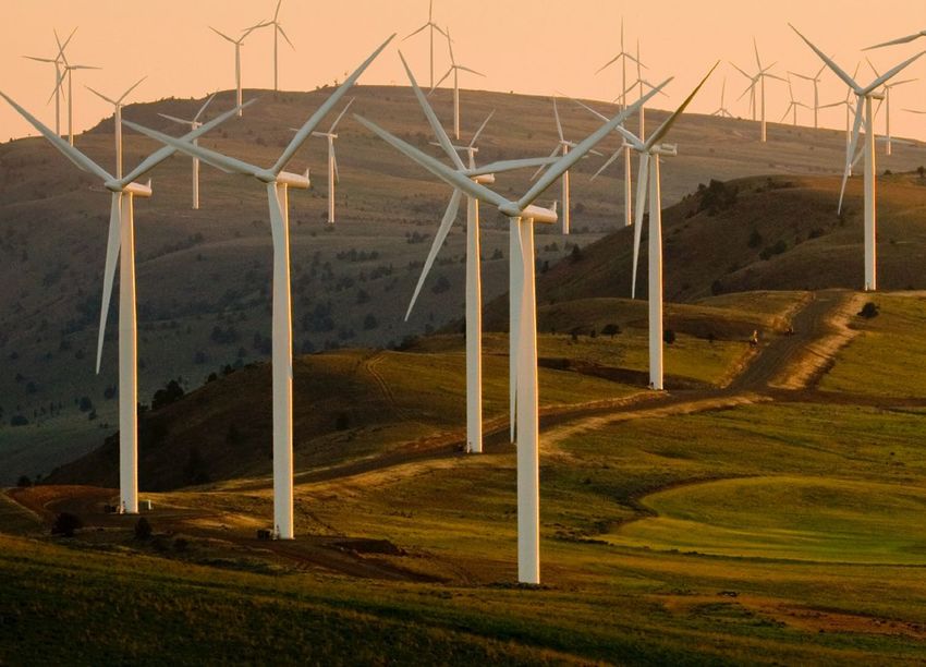
Scanning lidar in
wind energy:
Key applications and benefits
←
→
Page content transcription
If your browser does not render page correctly, please read the page content below
Scanning lidar in wind energy: Key applications and benefits
When certainty is the most valuable resource
In wind energy, millions of dollars depend on
developers' and operators' ability to reduce risk
and establish certainty. But certainty is hard to
come by, whether it’s in wind measurement and
performance estimations, power assessments, wake
and blockage impacts, or other factors.

That’s because, all too often, the available wind
data is based on historical records, outputs from met
masts that likely don’t cover the whole operating
region or rotor sweep of today’s modern turbines,
and extrapolations that can introduce bias.

                                                            MET MAST
    It’s like building a puzzle with
    some of the pieces missing. You
    might be able to identify the
    general picture, but you can't
    understand the details.

In wind energy, the details are where
money is made and lost.                                 Coverage needed   Met mast coverage

                                                                                              © Vaisala 2021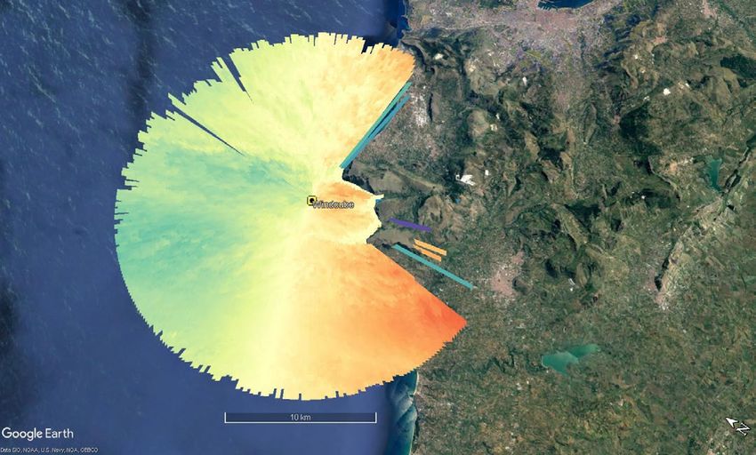
The arrival of scanning lidar
Lidar is not new to wind energy. By now, users across
the globe have deployed and validated thousands of
lidar units — particularly vertical profilers — for various
purposes. They have emerged as the ideal supplement
(and sometimes replacement) for met masts and other
traditional wind assessment methods.

But today, progressive companies — especially offshore
developers — are also using scanning lidar for an even
fuller, 3D understanding of the wind environment.

In part, scanning lidar is a response to recent trends
in wind energy. Wind parks, particularly in Europe, are
being built closer to each to other and are influencing
each other’s energy production. Offshore projects             MET MAST

are also becoming more common, complicating wind
resource assessment and other processes. Additionally,
today’s turbines are much larger than those of even 10
years ago, which brings both potential and risk. Their
performance and bankability are becoming harder
to assess.

    This ebook explains the principles and key
    applications of scanning lidar — and shows
    why it’s becoming some companies’ new                          Met mast coverage   WindCube Scan coverage area
    secret weapon in the quest for certainty.

                                                                                                                     © Vaisala 2021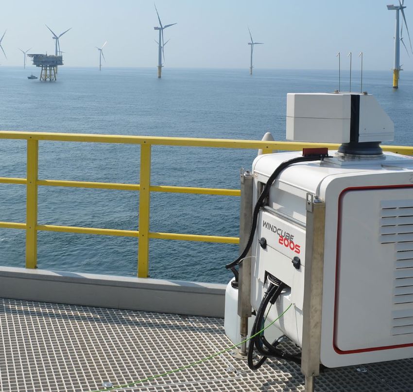
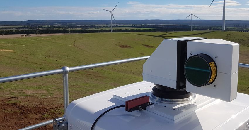
How scanning lidar works
Like a vertical profile lidar, scanning lidar uses laser pulses that are sent into the atmosphere and reflected
by aerosols or particulates traveling within it. When the light is backscattered and returned to the lidar unit,
the Doppler shift can be calculated, providing an accurate wind speed measurement.

Unlike vertical profilers, however, scanning lidar units measure across 360˚ using several scanning patterns,
up to ranges of 19.5km in the case of Leosphere’s WindCube® Scan, which is covered in detail later.

This provides 3D spatial wind awareness and, among other benefits, allows operators to assess several
turbines at once. This creates enormous efficiency, increases wind assessment certainty, and improves both
the quality and the quantity of available wind data.

                                                                                                                   © Vaisala 2021
Reducing spatial uncertainty
Improving certainty, decision-making,
and bankability

Wind developers are familiar with using mathematical models to
estimate the wind characteristics of a farm site. However, these models
are usually based on several limiting assumptions and are missing the
true complexity of the atmosphere, as well as complex terrain and
weather effects.

As a result, relying on traditional models requires some educated
guesswork on the part of the developers.

Scanning lidar dramatically reduces this guesswork, allowing developers
to check and refine existing wind models. Because the lidar provides so
much more localized data and less spatial uncertainty, developers can
add correction factors to their models and optimize them over time.

This is especially valuable for offshore development, where wind farms
are the largest and met masts either don't exist or cannot be installed.
Scanning lidar can be operated onshore while measuring offshore areas,
or located on remote platforms, dramatically increasing the range and
detail of wind data.

The practical outcome of this awareness is reduced vertical and spatial
uncertainty. Planners can make better turbine selections (creating         More and more offshore developers are
financial and performance benefits through the life of the site) and       choosing scanning lidar to fill important
understand the performance impacts of neighboring wind sites. They         gaps in their wind data.
can also validate and improve other measurement outputs, improving
the financial viability of a project.

                                                                                                                       © Vaisala 2021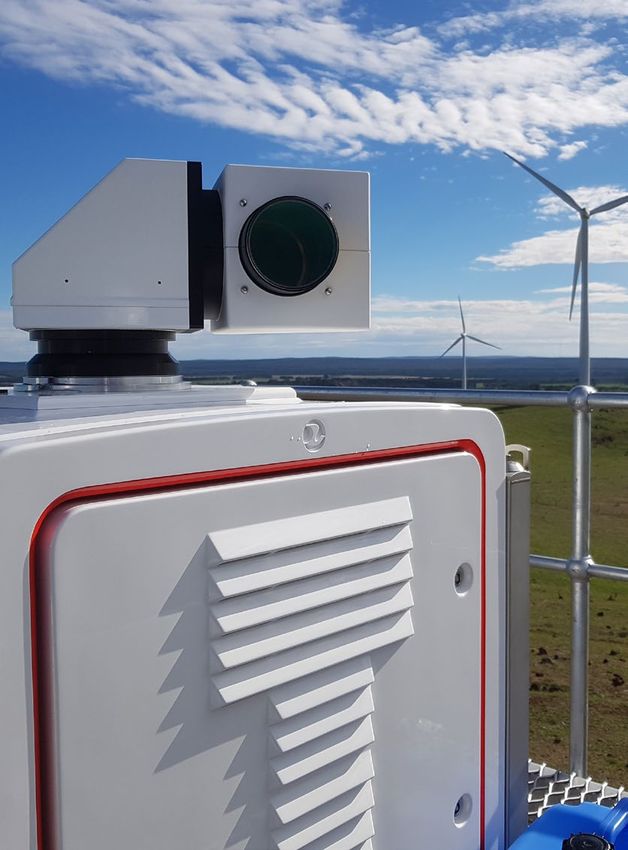
Case study:                                                          Case study:

WindCube Scan 400S campaign                                          WindCube Scan 400S campaign

For 6 weeks, ENGIE used a WindCube Scan 400S conveniently            For 4 months, Carbon Trust and RES used several lidar
deployed on the shore to measure offshore in the Southern Coast of   measurements on the shore to measure offshore in the Dublin Bay.
France.
                                                                     Challenge:
Challenge:                                                           Spatial uncertainty was a problem here as well, likely creating
Spatial uncertainty from mesoscale models is up to 2.5%, and every   negative financial impact.
uncertainty has a financial impact.
                                                                     Solution:
Solution:                                                            Use different scanning lidar configurations to measure spatial
Calibrate the mesoscale model with WindCube data.                    variation in wind resource offshore.

Results:                                                             Results:
Significant error from the model was detected near the coast, so a   Spatial uncertainty can be reduced to 1.3% by using scanning lidars.
correction factor was added.

                                                                                                                                            © Vaisala
                                                                                                                                      © Vaisala 2021 2020
Managing turbine and farm interactions
Understanding complex influences
As today’s turbines increase in size and power, one
turbine can have a significant effect on another.
Multiply those effects by the turbines on an entire
farm and the downstream consequences can be
large — even on neighboring wind farms.

To address this, developers need a reliable
understanding of wake effects and the ideal wind
farm layouts. This allows them to avoid performance
sacrifices within their own farm, plan expansions
more effectively, and mitigate problematic
interactions with neighboring farms.

Scanning lidar provides a real-time check of multiple
turbines’ wake effects, which allows customers to
optimize design and construction. If developers and
operators do their wake assessments early, they can     The startling costs of blockage and wake
choose different turbines or yaw angles to optimize     effects
the secondary turbines’ performance.
                                                        Lidar is finally helping developers and operators
                                                        understand the costs of blockage and wake effects,
                                                        which can rise to the millions or billions (¤) over time.
                                                        Only with a solid understanding of these complex
                                                        influences can operators protect their investments and
                                                        get the most from their wind farms.

                                                                                                                    © Vaisala 2021
Case study:                                                            Case study:

WindCube Scan 100S campaign                                            WindCube Scan 200S campaign

For 4 months, a WindCube Scan 100S was used on the FINO1               For 6 months, Goldwind used a WindCube Scan 200S to characterize
platform in Germany in order to analyze the performances of a wind     the wind field within part of a wind farm.
turbine from the Alpha Ventus wind farm.
                                                                       Challenge:
Challenge:                                                             AEP and wind farm layout deduced from a model can have high
A significant part of the Annual Energy Production (AEP) uncertainty   uncertainties.
comes from models.
                                                                       Solution:
Solution:                                                              Use a scanning lidar unit to characterize the wake effect of several
Make high-resolution measurements with a scanning lidar and            wind turbines.
calibrate the wake models.
                                                                       Results:
Results:                                                               The influence of multiple wakes was analyzed, and a wind turbine
A near-wake and a far-wake model were proposed, and the                was observed to be in the wake area of another wind turbine.
scanning lidar allows operators to bridge the gap between the          This identified an important AEP loss not considered in the
models and the data observed.                                          development phase, and identified ways to improve wind farm
                                                                       design and operation.

                                                                                                                                           © Vaisala
                                                                                                                                     © Vaisala 2021 2020
Innovating for higher performance
Innovations coming to wind energy Power curve testing
With so much flexibility and wind knowledge Power curve testing can be burdensome for
provided by scanning lidar, the industry is evolving developers and operators. But with scanning lidar,
rapidly. Two important examples are short-term several turbines can be assessed at the same time
forecasting and power curve testing. — dramatically lessening the burden and providing
better data. The lidar also provides simplified
Short-term forecasting installation and operation. It is often used onshore
or on a platform for offshore measurement, since
In R&D studies, properly placed scanning lidar units it can measure up to 14.7km, making it mobile and
reliably give operators 5–10 minutes of advanced simple to install and maintain.
notice if a storm or wind disruption is headed
toward the wind farm. This could benefit operators Scanning lidar provides an important baseline
as well as power grid managers, potentially understanding of the entire turbine fleet. Over time,
allowing them to proactively manage energy operators can spot-check turbines to see how well
production and its introduction into the grid. they are performing against estimates. One related
benefit is that, as OEMs start to sell performance
On the operator end, this warning time might allow upgrades, operators can use their baselines to judge
for adjustments (or even shutdown) of turbines whether the upgrade is worth it.
ahead of a dramatic wind or storm event. Power
grid managers, noticing a surge or drop in wind For short-term measurement campaigns, a rented
farm production, might anticipate what other scanning lidar permits customers to obtain baseline
power source might be used to compensate in the data and then either return or reassign the lidar
short term. units, reducing financial outlay.
© Vaisala 2021Case study: Case study:
WindCube Scan 100S campaign WindCube Scan 100S campaign
For 3 months, SSE used a WindCube Scan 100S on the transition For 3 months, Oldenburg University used three WindCube Scan
piece of a wind turbine in the Greater Gabbard wind farm in the UK 200S units for short-term
in order to make a power curve verification. forecasting offshore.
Challenge: Challenge:
In cases where there is no offshore met mast to do power curve Grid operators require accurate and short-term forecasting of
verification, installing one can be very costly. A nacelle-mounted electricity production, and the electricity market requires high
lidar also might not be an option due to wind turbine warranty reactivity.
constraints.
Solution:
Solution: Use three scanning lidar units to measure up to 6km distant and
Obtain hub-height measurements with the scanning forecast near-coastal wind conditions with lead times of 5 minutes.
lidar from the transition piece.
Results:
Results: The scanning lidar units are likely to decrease uncertainties
The power curve assessment was successful, and the study compared to statistical models, since any wind changes are
suggested that PPT for several turbines can be performed at the measured directly and not assumed (or missed completely), as
same time with just one lidar unit. The lidar data was shown to be with models.
equivalent to met mast data.
© Vaisala
© Vaisala 2021 2020WindCube Scan
Long-range wind awareness for certainty and decision-making
WindCube Scan is the industry-standard scanning lidar. It provides full 3D scanning up to
14.7km and multiple scanning patterns, making it ideal for many campaign types. Built on
proven, reliable WindCube technology, the system provides outstanding uptime, reliability,
and user-friendly software.
The system is well-suited for short-term development campaigns or long-term operations,
and its rugged, industrial design withstands extreme environments. Importantly, its data is
easy to export, understand, and put to use.
WindCube Scan series specifications
100S 200S 400S
Typical wind
3km 6km 10km
measurement range
Maximum range 19.5km 19.5km 19.5km
Scanner rotation speed Up to 30°/s
Accumulation time From 0.1s to 10s
Data transfer Ethernet/LAN
Data format Export in NetCDF by graphic interface or to FTP server
API type and REST web API; Lidar configuration and monitoring; status/activities/logs
functionalities monitoring; data download (JSON stream and NetCDF files)
Available scanning Any combination of PPI, RHI, DBS and fixed beam is possible and fully
strategy configurable by user
Weight 232kg (without options)
Temperature range -30°C to +45°C (-22° to 113 F°)
Power consumption 500W to 1.600W
© Vaisala 2021Conclusion:
Toward awareness and certainty
Wind energy is changing. Larger turbine designs, big offshore wind farms,
and plenty of other factors are disrupting the field — but there are new
tools for obtaining certainty in an environment where even 0.1m/s of wind
speed can amount to millions (€) of gain or loss.
WindCube units are in service around the globe with some of the world’s
largest wind energy players, as well as plenty of smaller, emerging ones.
They provide the rich data that developers, operators, manufacturers,
service providers, and many more stakeholders need to make better
decisions and maximize the return on their investments.
Support and services you can count on
Wind energy isn’t just about technology. It’s about having the backing
of a global partner that can directly support your business end-to-end,
with complementary services, robust customer service, and consultation.
Today, WindCube lidar technology is also backed by Vaisala’s 80 years of
experience and worldwide services.
Learn more about how scanning lidar can help you improve certainty,
efficiency and bankability.
© Vaisala 2020Why Leosphere, a Vaisala company?
We are modern innovators, scientists, and discoverers who enable our customers to harness the power of wind energy in new ways. We are driven by passion,
relentless curiosity, and the desire to create a better world, as evidenced in our commitment to four guiding principles:
Trustworthy, superior metrology Innovative lidars from a one-stop shop
Our solutions are backed by the best science and metrology, and Customers know we have the right suite of solutions for their needs
validated by the most demanding testing and certifications in in wind energy — taking them ever higher by adding value at each
the industry. Our contributions make wind energy smarter. step of the project lifecycle.
Unrivaled thought leadership Easy, reliable global solution
Our years of experience, impressive global client roster, and We make our clients’ lives easier. Our easy to use, turnkey WindCube
plethora of industry breakthroughs demonstrate the we are the product suite enables customers to harness the power of wind
iconic gold standard in wind energy. energy efficiently and affordably.
As a result, Leosphere, a Vaisala company, is the iconic and trusted gold standard in wind lidar. Our turnkey WindCube product suite offers innovative, reliable, and
highly accurate solutions for thousands of customers across the globe. All of this has enabled us to be catalysts for change and ambassadors for wind energy, always
advancing the field and those we serve.
Our innovation story, like the wind energy story, continues.
windcubelidar.com
Ref. B212128EN-C ©Vaisala 2021
This material is subject to copyright protection, with all copyrights retained by Vaisala and its individual
partners. All rights reserved. Any logos and/or product names are trademarks of Vaisala or its individual
partners. The reproduction, transfer, distribution or storage of information contained in this ebook in any
form without the prior written consent of Vaisala is strictly prohibited. All specifications — technical included
— are subject to change without notice.You can also read