Semiotic study of settlement's spatial pattern in Kuningan Regency, West Java
←
→
Page content transcription
If your browser does not render page correctly, please read the page content below
e-ISSN 2597-9949
JGLITrop Vol.5, No.1, April 2021
© 2021 Department of Geography FMIPA UI
Journal homepage: www.jglitrop.ui.ac.id

Semiotic study of settlement’s spatial pattern in
Kuningan Regency, West Java

             Muhamad Iko Kersapati1, Hafid Setiadi2
            1,2
               Department of Geography, Faculty of Mathematics and Natural Sciences, Universitas
             Indonesia

             E-mail: muhamad.iko@sci.ui.ac.id

             Received: 14 Dec 2020; Accepted: 17 Feb 2021; Published: 30 April 2021

             Abstract. This study discusses how people in Kuningan Regency divided into indigenous and
             immigrant communities interpret human relations with nature as well as changes in the context of
             the natural environment identified through the configuration of the components of the settlements.
             The observed natural environments include water, land, forest, and mountains, while the settlement
             components include houses, village halls, mosques, cemeteries, and rice fields. The data used in
             this study is qualitative data from various literature, maps, observations, and in-depth interviews.
             The method used in this study is the method of interpretation to reveal the meaning behind the
             spatial pattern of settlement as a unity of signs. The results reveal that the influence of water and
             land was more dominant in nature-depended traditional settlement and transition settlement.
             Meanwhile, forests and mountains did not have a major impact on the spatial patterns of all three
             categories of settlements.
             Keywords: Spatial Pattern, Sundanese Philosophy, Semiotics, Settlement, Cultural Geography.

1. Introduction
The discussions about the relationship between humans and nature have been debated for years,
especially in various geographical studies (KŐSZEGI et al, 2015). The development of humanistic
thinking in geography gives an effect on the study of the man-land relationship tradition by emphasizing
the “human” element without neglecting the “environment” (Robinson, 2007). The core of the thought
lies not in the environmental phenomenon, but on the thing that is truly believed and perceived by the
human to the environment so that the critical aspect in the human-environmental relationship lies in the
thinking of man himself.
   This development prompts questions about how humans react or behave to their environment, both
natural and social. The discussion of human reactions and behavior is useful in describing the meaning
of the natural environment in which one lives specifically to measure the “degree” of human-
environmental relations (Hardin, 2009). Through the theory of determinism, one or more factors that
affect the characteristics of a society or an individual can be interpreted through the cultural ecology
model (Fekadu, 2014).
    This model shows that aspects of the life of a society are valued based on environmental parameters
(Milton, 2002). In contrast, an alternative point of view on environmental limitations through historical
and cultural factors indicates that there are other possibilities that humans can choose from. The
possibilism view claims that although nature has always limited man, historical and cultural factors

                                                       1
2

suggest that there are other possibilities for man to choose from. The scholars argue that the difference
between one culture and another is not influenced by environmental factors, but is the result of a specific
historical course of a society. This shows that the scholars interpreted culture as a result of
environmental selection (Mairs, 2007).
    Humans are always adapting and active in their environment (Anshoriy, 2008). As the 2nd largest
ethnic group in Indonesia, the Sundanese uphold the preservation of nature. This is because most of the
traditional (primordial) communities depend on nature through agricultural activities (Angelsen, 2011).
For them, natural resources such as water, land, and forests are gifts that must be maintained so that
they can continue to be utilized. This condition can only occur with dualistic harmony. Dualistic is
anything that is a binary pair and contradicts one another. This view is prominent in the culture of
agricultural farmers in Indonesia, one of which is the Sundanese culture.
     Tritangtu (unity of three) philosophy as the foundation of the Sundanese cosmology becomes the
basis in various aspects of life which is realized in the spatial pattern of settlement (residence). This
philosophy is transcendent: the unity of nature between heaven, earth, and humans (metacosm). Heaven
is a ‘Kawasa’ (impression) with humans as the thought, the earth is ‘Kawasa’ which has meaning as
growing plants for human welfare. Sundanese culture symbolizes the sky as water, man as stone, and
earth as land. Thus, the unity of three is manifested metacosm, the macrocosm, and microcosm.
     The concept of Tritangtu is a ‘marriage’ of a pair of basic oppositions in all respects. This opposition
is a division of ‘men’ and ‘women’. This marriage whelps a third entity, the ‘child’. This ambivalent
concept of ‘child’ contains elements of ‘man’ and ‘woman’ and is a middle world that serves as the
medium of the two oppositions (Sumardjo, 2011). In the discourse of cultural landscapes, the residence
is positioned as an “alternative, more holistic means of expressing human beings-in-the-world” (Wylie,
2007). The discussion about the pattern is studied through aspects of form and meaning. A form is
created as a symbol of ideology and represents the human thought in accommodating an activity and
function that is interpreted as a particular meaning (Salura, 2007). While the meaning as being
interpreted through a form in the spatial pattern is closely related to daily life.
     Kuningan Regency has a strong interaction between man and nature. It is characterized by the great
potential in the agricultural sector as the main livelihood. This is strongly supported by good soil
fertility. Besides, as one of the areas that were once part of the power of Parahyangan (ancestors),
cannot be separated from the influence of Kesultanan (Sultanate) Cirebon (Ekadjati, 2003). Cirebon
culture which is a blend of elements of Java and Sunda brings influence in socio-cultural aspects in this
region. This phenomenon implies that the Kuningan regency is more open that allows the occurrence
of cultural penetration from outside into the region.
     The man-land relationship as a cultural identity of the Kuningan people can be seen through the
ritual of ‘Seren Taun – Ngajayak’. This ritual is a harvest thanksgiving ritual from the Sundanese
agrarian community which is carried out after every harvest (A & Widiastuti, 2014). Seren Taun
consists of two words, ‘Nyerenkeun’ (replace, deliver) and ‘Taun’ (year). This procession is a form of
cooperation to offer crops as a form of gratitude for the people. The process of ‘Ngajayak’ or ‘Mapag’
pare (picking up rice) is a procession of picking up rice seeds and crops from the villages in the Cigugur
Sundanese Customary Unit to the core area called ‘Paseban’. However, the ‘Seren Taun’ ritual has a
varied sequence of processions in different places and communities.
    The physical and historical environmental factors owned by Kuningan Regency make the spatial
pattern of settlement space an interesting topic to be studied. This study discusses how the inhabitants
of Kuningan (indigenous people and immigrants) interpret the relationship of humans with nature
identified through the spatial pattern of settlement. the humanistic approach is used through semiotics
(the study of signs and meanings) (Aitken & Valentine, 2006). The meaning of space by various groups
is emphasized in an overlapping of the landscape stories. This research lies to the two basic questions:

          Kersapati & Setiadi (2021). Jurnal Geografi Lingkungan Tropik (Journal of Geography of Tropical Environments), 5 (1), 1-22
3

(1) How do the residents perceive the natural environment? (2) How is the relationship between the
natural environment and the spatial pattern of settlements?
2. Research Methodology
2.1. Location of Research
This study was conducted in three administrative village areas: (1) Tarikolot Village as the
representative of the category of traditional settlements depend on nature; (2) Karang Tengah Village
as the category of transitional settlements; And (3) Kuningan Village, as the category of modern urban
settlements.
    The observed settlement group includes one settlement segment determined by a village hall and
the main road that connects the village hall with other settlement components (houses, mosques,
cemeteries, and rice fields). The following map shows three points of the research location in three
different villages.

                                             Figure 1. Research Location
2.2. Conceptual Framework
This research discusses how the perception of the population in the Kuningan Regency area of the
natural environment which includes water, land, forests, and mountains in their daily life through the
spatial configuration of settlement elements that include houses, village halls, mosques, cemeteries, and
rice fields. Social dynamics result in the possibility of different meanings within each social group. This
difference raises a heterogeneous meaning in the relationship between humans and the environment
(Adian, 2006). Thus, the settlements are categorized according to their social units.
   An understanding of people’s perceptions in interpreting the natural environment is retrieved
through the study of textbook literature, journals, and previous research. Researchers look for categories

          Kersapati & Setiadi (2021). Jurnal Geografi Lingkungan Tropik (Journal of Geography of Tropical Environments), 5 (1), 1-22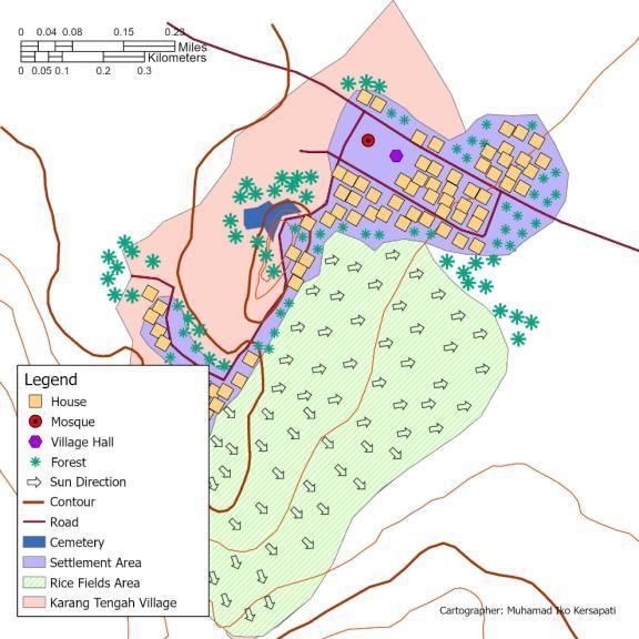
4

that form a pattern (Creswell, 2013). The process starts from pre-understanding built by collecting
related information from various literature and maps as a unit of research analysis. Another data source
is in-depth interviews with informants who are considered to be able to represent each category of
settlement. The settlements as a unit of analysis are grouped into three categories:
                                          Table 1. Category of Settlements
      Model            Traditional settlements                     Transitional                        Modern
                         depend on nature                          settlements                     urban settlements

 Dominant             Sundanese                          Sundanese                          Mix Sundanese Javanese
 Ethnic Group

 Dominant             Agriculture                        Agriculture                        Agriculture
 Livelihood

 Water                Simple (natural water              Complex (natural water             Complex (Modern water
 Processing           resources used directly            resources used for                 treatment processing
 Technology           for rice fields and                households using                   systems for households
                      households)                        irrigation systems)                needs)

 Availability of      Not available                      Available                          Available
 City Transport

   Steps of data collecting for this research are:
   a. Literature Studies. From the results of literature studies, the following categorization of
      settlements was identified. This study emphasizes the differences in how indigenous
      (Sundanese) and immigrants (Java and other ethnic groups) interpret their settlement space. This
      data collection method is carried out by examining library sources such as books, journals, and
      previous research theses to obtain relevant theories and can be used in assessing settlement
      spatial patterns.
   b. Field Observation. This step is exploratory which aims to assess the suitability of settlement
      categories through field findings and allows for revision of categories including the selection of
      prospective informants before conducting interviews.
   c. In-depth Interview. After obtaining a description of the research location, an in-depth interview
      was conducted using the question-and-answer method to parties who could provide explanations
      as informants related to in-depth research. The parties referred to are people who best represent
      their group in a settlement, such as a village head or ethnic leader.
   d. Documentation. Carried out by taking pictures, videos, and voice recordings during field
      observations and in-depth interviews. Documentation is very important in qualitative research
      because it is evidence of validity and a complementary source in conducting data analysis
      (Rahardjo, 2017).
   The in-depth interviews verbatim and other qualitative data are processed and analyzed into a
descriptive narrative of the effect of the natural environment on the spatial patterns of settlements in the
Kuningan Regency. The following is a scheme that describes the conceptual framework.

          Kersapati & Setiadi (2021). Jurnal Geografi Lingkungan Tropik (Journal of Geography of Tropical Environments), 5 (1), 1-22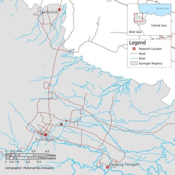
5

                                          Figure 2. Conceptual Framework
2.3. Interpretation and Map Producing
The interpretation method in this study uses the concept of hermeneutics which always involves two
dimensions: language as events and language as sign systems (semiotics) through an interpretation of
the text (Adian, 2006). In geographic science, signs are not only letters, numbers, or graphic symbols,
but also signs found on maps, fields, and actions which can be related to the concept of social formation
and symbolic landscape approaches as a geographic view of signs (Backhaus & Murungi, 2009).
Geographers equate landscape with text: try to understand the landscape as a written text.
    In practice, hermeneutics as a method uses text as a place for interpretation by the reader and each
reader has his interpretation (subjective). Therefore, the text acts as an entity that has its internal
structure and the interpretation of the text is no longer a discourse between the writer and the reader,
but between the text and the reader through the meaning contained in the text with several references.
    At the map-making stage, the integration of qualitative geographic methods will provide a more
comprehensive explanation. After the data is collected from various sources, geocoding and
georeferencing techniques are carried out to obtain the spatial features of the qualitative information in
the shape of points, lines, and areas. Geocoding is the process of converting location descriptions (such
as coordinates, addresses, or name of places) to locations on the earth's surface, while georeferencing
is the process of transforming scanned maps or aerial photographs and satellite imagery so that they can
be identified somewhere on the earth's surface with using spatial data processing software (ESRI, 2017).
The spatial data processing software used in this study is ArcGIS Pro 2.7.
   This study aims to uncover the meaning behind the spatial pattern of settlement as multiple signs.
Technically, the interpretation of social and historical space makes the study of geography not only
show symptoms and patterns but also explain the structure and processes that take place in space (Dear
& Flusty, 2002). Overall, the interpretation method above includes four main elements (Setiadi, 2011):
       a. The researcher as an interpreter;
       b. Settlement’s spatial patterns as traces of human action or text;

          Kersapati & Setiadi (2021). Jurnal Geografi Lingkungan Tropik (Journal of Geography of Tropical Environments), 5 (1), 1-22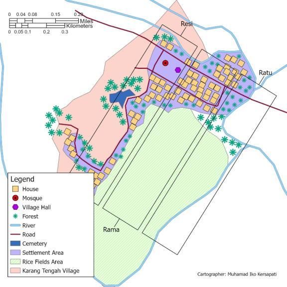
6

       c. Human interaction with the natural environment as a form of human action in producing
          space;
       d. Kuningan residents as the actors.
   The interpretation process in this study is described as follows.

                                         Figure 3. Method of Interpretation
2.4. Previous Research
Research on settlements and aspects of form and meaning in it is a topic that is researched across
disciplines by several scientific fields. The scientific fields with the most themes on settlement patterns
include architectural engineering, civil engineering, and regional planning techniques.
    The difference between this study compared to several previous studies lies in the emphasis on the
observed aspects, in which geography as a science that studies the relationship between humans and the
environment and the pattern of their distribution on earth raises the perception of Kuningan residents
towards the natural environment as a meaning that is manifested in the pattern of residential spaces as
a form. The following are some similar previous studies regarding the spatial pattern of settlements.
3. Results and Discussion
The results of interviews regarding perceptions of the natural environment were processed and analyzed
using the triangulation and interpretation methods. Then we get an overview of Kuningan residents’
perceptions of the natural environment.
   Then the influence of the natural environment on the spatial pattern of settlement is interpreted by
linking the perceptions (meaning) of the informants regarding the natural environment to the physical
appearance (form) of the pattern.

          Kersapati & Setiadi (2021). Jurnal Geografi Lingkungan Tropik (Journal of Geography of Tropical Environments), 5 (1), 1-22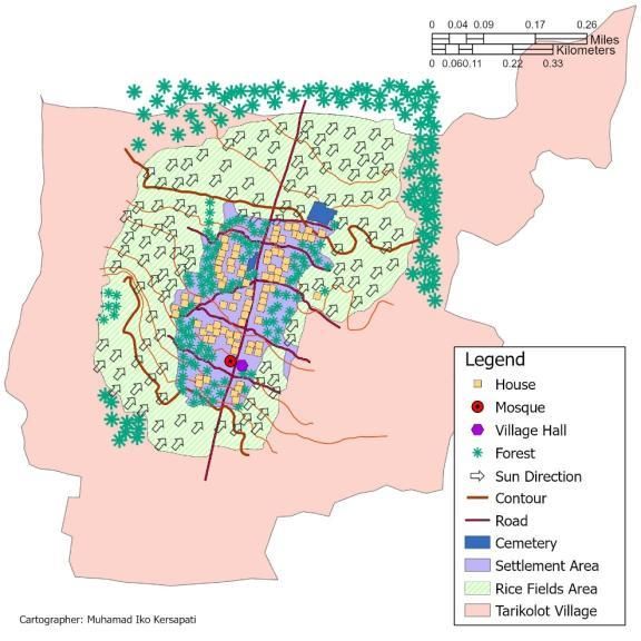
7

                                                Table 2. Previous Research
   Author                                 Title                              Publi-        Year                Affiliation
                                                                             cation
K. Fekadu          The Paradox in Environmental                            Journal        2014        Department of
                   Determinism and                                                                    Geography and
                   Possibilism                                                                        Environmental Studies,
                                                                                                      Arba Minch University,
                                                                                                      Ethiopia.
KŐSZEGI,           Human-Environment Relationships in                      Journal        2015        Department of Physical
et. al             Modern and Postmodern Geography                                                    Geography, Eötvös
                                                                                                      Loránd University,
                                                                                                      Budapest
Kustianingru       Kajian Pola Penataan Massa &                            Journal        2013        Faculty of Civil
m, D., et. al      Tipologi Bentuk Bangunan Kampung                                                   Engineering and
                   Adat Dukuh di Garut, Jawa Barat                                                    Planning, National
                   (Study of Mass Arrangement &                                                       Insitute of Technology
                   Typology Patterns of Building in the
                   Traditional Village of Dukuh in Garut,
                   West Java)

Primadewi,         Inkulturasi Arsitektur Tradisional Bali                 Journal        2013        Faculty of Engineering,
S.                 Dalam Pola Spasial Rumah Etnis                                                     Mahasaraswati Denpasar
                   Tionghoa di Desa Adat Carangsari,                                                  University
                   Badung (Inculturation of Balinese
                   Traditional Architecture in Spatial
                   Patterns of Chinese Ethnic Houses in
                   Carangsari Traditional Village,
                   Badung)
Lamus, I., et.     Identifikasi Arsitektur Rumah Tinggal                   Report         2015        Architecture, Faculty of
al                 di Desa Pakraman Bugbug,                                                           Engineering, Udayana
                   Kecamatan Karangasem                                                               University
                   (Identification of Residential
                   Architecture in Pakraman Bugbug
                   Village, Karangasem District)

Cahyandari         Tata Ruang & Elemen Arsitektur pada                     Journal        2014        Architecture, Atma Jaya
& Gerarda          Rumah Jawa di Yogyakarta (Spatial                                                  Yogyakarta University
O.                 Planning & Architectural Elements in
                   Javanese Houses in Yogyakarta)

Raaphorst,         The Semiotics of Landscape Design                       Journal        2016        Landscape Architecture
K., et. al         Communication: Towards a Critical                                                  Group, Wageningen
                   Visual Research Approach in                                                        University
                   Landscape Architecture
Raaphorst,         Reading Landscape Design                                Journal        2020        Landscape Architecture
K., et. al         Representations                                                                    Group, Wageningen
                   as Aa Interplay of Validity,                                                       University
                   Readability
                   and Interactivity: A Framework For
                   Visual
                   Content Analysis

             Kersapati & Setiadi (2021). Jurnal Geografi Lingkungan Tropik (Journal of Geography of Tropical Environments), 5 (1), 1-22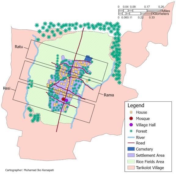
8

3.1. Perceptions to the Natural Environment
The informants’ perceptions were analyzed regarding four natural elements: water, land, forests, and
mountains. The following table shows the informants who were interviewed.
                                             Table 3. Data of Informants
  Settlements Category             Village         Name        Gender       Age        Occupation          Residence Status
 Traditional settlements         Tarikolot        Oyi         Female        53       Farmer,               Indigenous
 depend on nature                                                                    broom maker

 Transitional                    Karang           Jaid        Male          66       Village Head          Indigenous
 settlements                     Tengah           Udaya

 Modern                          Kuningan         Wisnu       Male          44       Electronics           Immigrant (Java)
 urban settlements                                Utama                              merchant

3.1.1.   Water
Interview with Informant 1 showed that water is the main source of life. The main source of water
where he lives comes from the Kertawinangun spring. Besides, the informants considered that rivers
are a source of water reserves during the dry season.
   “Ya kalo aer mah itu istilahnya amerta. Kalo ga ada aer ga bisa mandi, nyuci, masak, segala
macem… Dipake. Kalo musim kemarau tuh suka mandi ke sono (sungai). Nyuci pakean ke sono. Kan
sumurnya pada kering.” (Oyi, 2017)
   Translation:
   “Yes, water is called ‘Amerta’. If there is no water, you cannot bathe, wash, cook, and so on... It is
used. When the dry season comes, we often bathe there (river). Washing clothes over there, when the
well is dry.”
   This statement shows that the role of water is very essential in their life (‘Amerta’ means eternal).
This is supported by the results of the interview with Informant 2 which revealed that water is one of
the important elements that make up a village.
   “Kalo ciri khas Karang Tengah itu ada sejarah Cibuni. Cibuni itu yang dikatakan aer dari mata aer
ke sini (kampung) lalu membludak dan sekarang tuh masih bagus aernya dan masih jadi sumber aer
utama masyarakat di sini.” (Udaya, 2017)
   Translation:
    “The characteristic of Karang Tengah is the history of ‘Cibuni’, which is said to be water from a
spring here (village) and then booming and now the water is still good and is still the main water source
for the people here.”
    The word ‘Cibuni’ has a meaning, ‘Ci’ means water or a source of light, and ‘Buni’ means hidden.
In the village of Karang Tengah, there is an abundant shower that comes out of the ‘Cibuni’ spring
known as Four Showers (‘Pancuran Empat’) because it has four tubes from one spring. The ‘Cibuni’
spring is hidden. This can be identified by the layout of four showers hidden in a forest-covered
residential area consisting of large, deliberately forested trees.

          Kersapati & Setiadi (2021). Jurnal Geografi Lingkungan Tropik (Journal of Geography of Tropical Environments), 5 (1), 1-22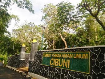
9

                                Figure 4. ‘Pancuran Empat’ at ‘Cibuni’ Spring
  In Sundanese traditional value, the features of the ‘Pancuran Empat’ layout forms have the same
meaning in the value of ‘Kabuyutan’ (a transcendent system that includes heaven, earth, and humans)
which are represented through elements of the forest, water, and stone artifacts (Sumardjo, 2011).
    Although the formal appearance of the shower building has undergone modernization (permanent
building), the Kabuyutan element can still be identified from the forest cover which consists of large
trees that are intentionally forested. A different thing is shown by Informant 3 who revealed that the
main water source where he lives comes from the processing of the Kuningan Regency PDAM.
   “Kita di sini pakenya air PAM…Kali mah di sini itu di belakang, tapi udah ga di pake buat apa-
apa. Paling kalo banjir (saluran), gitu.” (Utama, 2017)
   Translation:
  “We are here using processed water... The river is in the behind there, but it's not used for anything.
Except for the floods (channel).”
   This statement shows that the informants no longer depend directly on natural water sources. This
function is replaced by modern technology water treatment originating from the Municipal Water
Treatment System (PDAM) to fulfill daily water needs.
3.1.2.   Land/Soil
Informant 1 showed that land has a main function as rice fields.
   “Tanah biasanya buat taneman, itu ya bisa sawah, kebon juga bisa… Itu sana nih dari ini
perbatasan sini (menunjuk ke arah utara) yang sebelah kulon.” (Oyi, 2017)
   Translation:
   “The land is usually used for crops such as rice fields and gardens... From this border (from the
north) to the west.”
    The soil has a function as a medium for crops both for rice fields and gardens. This is supported by
literature that in Sundanese traditional value, the land has a sacred meaning and acts as a complement
with water as ‘Eusi’ (content) (Sumardjo, 2011). The land is interpreted as the tomb of Nyi Pohaci or
known as Dewi Sri (Goddess of paddy) which is the source of various food plants for human survival
(Sumardjo, 2011). This sacred meaning is manifested through the ‘Mapag Sri’ (customary ritual) as
part of the ‘Seren Taun’ ritual which is characteristic of Sundanese rituals in Kuningan Regency, as
stated by Informant 1.
   “Taun lalu mapag sri. Baru kemarin lagi nih kepala desanya yang baru.” (Oyi, 2017)
   Translation:

          Kersapati & Setiadi (2021). Jurnal Geografi Lingkungan Tropik (Journal of Geography of Tropical Environments), 5 (1), 1-22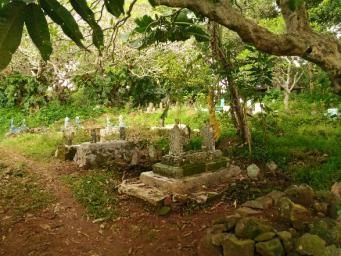
10

   “Last year we did a ‘Mapag Sri’ with the new village head.”
   Meanwhile, Informant 2 stated the function of the land as follows:
    “Tanah, itu fungsinya utamanya untuk pertanian khususnya sawah. Jadi istilahnya itu taneuh bahe
ngetan, itu artinya tanah yang bagus untuk pertanian, itu tanah yang agak miring sedikit menghadap
ke timur.” (Udaya, 2017)
   Translation:
  “Land has a main function for agriculture, especially rice fields. So it is referred to as ‘Taneuh Bahe
Ngetan’ which means land that is good for agriculture is sloping slightly to the east.”
   The term ‘Taneuh Bahe Ngetan’ means that the selection of land for agriculture is based on the
direction and slope of the land. Based on the theory, such land conditions are ideal places for settlement
and agriculture (Ardi, 2008). Rationally, this can be interpreted that areas with a slope of the land to the
east get more sunlight in the morning which is beneficial for human health and fertility of crops.
   Meanwhile, the results of interviews with Informant 3 indicate that the land functions as commercial
land for trade.
   “Oh buat modal usaha. Kalo di sini kan nyari sewa (tanah) gitu ya yang bagus prospeknya (untuk
perdagangan).” (Utama, 2017)
   Translation:
   “This is for business assets. We are looking for rent (land) with good prospects (for trade).”
   Statement from Informant 3 indicates that the selection of land is based on the rental price and
feasibility aspects of the location. This is because most of the population in the city has a livelihood as
traders or as owners of shop-houses that are rented out for business (non-agricultural) activities. The
choice of residence location is based on the orientation of accessibility and economic benefits. Most of
the shop owners in Kuningan City are not indigenous people who come from outside Kuningan
Regency.
3.1.3.   Forest
The perception of all informants regarding forests has the similarity that there is no taboo regarding
prohibited forests.
   “Ini sekitaran sawah. (hutan) udah ga ada…Nih dari rumah ini sawah (menunjuk ke arah utara)
terus ke itu lagi, desa lagi, perbatasan lagi desa Sarewu. Ke sana lagi perbatasan Kuningan.” (Oyi,
2017)
   Translation:
   “This is around the rice fields. It (forest) no longer exists… From this house to the rice fields
(pointing north) then that way again, to the border of Sarewu village. Towards the Kuningan border.”
   “Ga ada, kalo di sini ga ada hutan. Jadi ga dilarang. Cuma yang ga diperbolehkan jangan coba-
coba menebang pohon yang dilindungi seperti pinus, yang dilindungi oleh pemerintah itu tidak boleh
diganggu.” (Udaya, 2017)
   Translation:
    “Nothing, there is no forest here. So, it's not forbidden. The only thing that is not allowed, don't try
to cut down protected trees such as pine, which are protected by the government and should not be
disturbed.”

          Kersapati & Setiadi (2021). Jurnal Geografi Lingkungan Tropik (Journal of Geography of Tropical Environments), 5 (1), 1-22
11
“Hutan mah kayanya udah ga ada ya. Di sini-sini mah udah pada rumah terus toko-toko
kebanyakan.” (Utama, 2017)
Translation:
“The forest seems like it doesn't exist already, right? Here and there they have become houses and
shops.”
The statements of the three informants which indicate that forests do not have taboos such as the
prohibition of entering the forest are very different from the meaning of forests in Sundanese people in
the Kanekes (Baduy ethnic group) who still hold traditions related to prohibited forests (Sumardjo,
2011). This condition is because currently there are very few forests in the area where the informants
live. Besides, in the historical aspect, the influence of Javanese culture in Kuningan also has an impact
on the loss of the meaning of prohibited forest (Widyandini, Suprapti, & Rukayah, 2012).
3.1.4. Mountain
In Sundanese and Javanese culture, mountains are a sacred physical formation (Sumardjo, 2011). The
literature explains that in Sundanese traditional society, forests and mountains are natural entities that
are interpreted as sacred simultaneously (Putra, 2010). The forest is believed to be the residence of the
‘Parahyang’ (ancestors) so that it is sacred (Sumardjo, 2011). Meanwhile, mountains are defined as
places to gain natural knowledge based on the transcendent dimension called ‘Tapa di Mandala’ (Putra,
2010).
The results of interviews with the three informants indicate that Mount Ciremai currently does not
have a specific sacred value as sacred by the Cigugur Wiwitan Sundanese (indigenous community) who
call themselves ‘Urang Gunung’ (Tendi, 2015).
“Engga ada ya kalo gunung. Di sini mah kebanyakan ya di sawah aja.” (Oyi, 2017)
Translation:
“Not on the mountain. Here, mostly in the rice fields.”
“Ritual udah ga ada ke sana (gunung). Di sini mah ke sawah, ke gunung ga ada orang.” (Udaya,
2017)
Translation:
“The ritual is not there (the mountain). We go to the rice fields, to the mountains there are no people.”
“Wah ga tau kalo itu, kayanya juga ga ada ya.” (Utama, 2017)
Translation:
“Wah, I don't know about that, there's nothing like that in here.”
The statements of the three informants indicate that the concept of ‘Tapa di Mandala’ has been lost
or at least not widely known by the public. The sacred value of the mountain has now shifted and even
disappeared over time. This is influenced by the inclusion of modern value into the society in Kuningan
Regency which increasingly opens the boundaries of space in society to change a single society with a
single culture (bonded) towards a borderless society.
3.2. The Influence of Natural Environment on Settlement’s Spatial Patterns
The Interpretation of the forms and meanings in the pattern of settlement space is carried out at the
Macro-level (the unitary group of settlements against the natural environment entity) and the Meso-
level (configuration of settlement components in one settlement group).
Kersapati & Setiadi (2021). Jurnal Geografi Lingkungan Tropik (Journal of Geography of Tropical Environments), 5 (1), 1-2212
3.2.1. Water Spring as the Major Factor in Formation of Settlements
Springs as the main source of life for the Sundanese people influence the pattern of settlement space at
the Macro-level, the location of a group of settlements to the location of the spring that is on the lower
contour than the springs come out.
Figure 5. Position of Villages to the Springs
As explained by Informant 1, the main water source of Tarikolot Village comes from the
Kertawinangun spring.
“Ini dari sono nih dari rando bawah dari mata air. Kertawinangun. Tiap desa teh biasanya ada
sumber air. Aer ledeng, air bersih dibilangnya.” (Oyi, 2017)
Translation:
“This is from there from the rando bawah from the spring. Kertawinangun. Each village usually has
a water source. Called tap water, clean water.”
The crosscheck result of the topographic map shows that the village of Tarikolot is located in a lower
position in the northern part of the Kertawinangun spring which is located in the village of
Kertawinangun. Literature shows that the arrangement of the settlement in the village of Tarikolot
contains elements of the philosophy of ‘Lemah Cai’ and ‘Luhur Handap’. The concept of ‘Lemah Cai’
implies that the formation of a settlement requires two complementary elements, land (‘Lemah’) and
water (‘Cai’). Meanwhile, the concept of ‘Luhur Handap’ means that those in ‘Luhur’ (above) have a
higher value (Salura, 2007). This depicts that the role of water in everyday life is ‘Luhur’ (high).
Similar conditions also exist in Karang Tengah Village and Kuningan City. As explained by
Informant 2 regarding perceptions of water in the previous section, Karang Tengah Village is located
to the east of the ‘Cibuni’ spring which has a higher topography. The results of the interview with
Kersapati & Setiadi (2021). Jurnal Geografi Lingkungan Tropik (Journal of Geography of Tropical Environments), 5 (1), 1-2213
Informant 3 also support that the water comes from the Cigugur-Cipari Municipal Water Treatment
(PDAM) which is located in the northwest of Kuningan City.
“PAM-nya ya, itu katanya dari daerah Cigugur.” (Utama, 2017)
Translation:
“Water treatment, people say from the Cigugur area.”
Topographically, Cigugur Village is in the northwest with a higher contour than Kuningan City.
This shows that even though Kuningan Village experienced a development into a city, its relationship
with water sources still contains elements of ‘Lemah Cai’ and ‘Luhur Handap’.
3.2.2. River as the Unifier and Separator of the Settlement Area
Apart from being a source of water, rivers also have another role in the layout of a village. At the Macro-
level, the river acts as a unifier for the settlement area. The results of interviews with Informant 1
indicate that their settlement area was surrounded by rivers with other settlement groups.
Figure 6. Location of Tarikolot Settlements to River and Kabuyutan Division
“Kalo cai di sono ada, di sono ada. (menunjuk ke arah timur dan barat). Dibilangnya di sono mah
(menunjuk ke arah timur) sawah nya yang ada saradan gitu, dibilang sawah kebon balong gitu. Kalo
di sana (menunjuk ke arah barat) namanya Cikoneng dibilangnya, Sungai Suhud dibilangnya.” (Oyi,
2017)
Translation:
“The water is over there (pointing east and west). There it is called saradan, rice field, garden, pond
(pointing to the east). Over there, it is called Cikoneng, the Suhud river.”
Kersapati & Setiadi (2021). Jurnal Geografi Lingkungan Tropik (Journal of Geography of Tropical Environments), 5 (1), 1-2214
This statement indicates that the area where the informant lives in the area where the river meets. At
the Meso-level, the river acts as a separator for different parts of the settlement. This is supported by
Informant 2.
“Sungai itu dipake biasanya untuk membagi daerah di Desa Karang Tengah menjadi tiga bagian,
bagian hulu, tengah, hilir… Ini fungsinya untuk memudahkan (pembagian) warga. Balai desa dan
masjid itu selalu di depan awal masuk desa. Maksudnya itu desa dipimpin oleh seorang kuwu.” (Udaya,
2017)
Translation:
“The river is used to divide the area in Karang Tengah Village into three parts: upstream, middle,
downstream ... This serves to facilitate the division of territory by residents. The village hall and mosque
are always in front of the village entry point. It means that the village is led by a village head.”
Figure 7. Location of Karang Tengah Settlements to River and Kabuyutan Division
In traditional value, the division of the house to the river follows a triple pattern (‘Tri Tangtu’)
known as ‘Kabuyutan’. The upstream part is the ‘Kabuyutan Resi’ (head of religion), the middle part is
the ‘Kabuyutan Rama’ (traditional head), and the downstream is the ‘Kabuyutan Ratu’ (head of
government) (Sumardjo, 2011). Therefore, the location of the village hall and mosque is always at the
front (upstream).
The results of field observations show that the Tarikolot Village Hall was built opposite the mosque,
while the Karang Tengah Village Hall was built next to the mosque. The arrangement of the village hall
and mosque’s location which are close together means that government activities cannot be far from
the mosque (religion).
Kersapati & Setiadi (2021). Jurnal Geografi Lingkungan Tropik (Journal of Geography of Tropical Environments), 5 (1), 1-2215
This provides an understanding that everything determined through deliberation by the government
(‘Umaro’) must be based on religion (Islam). Therefore, referring to the concept of division of
Kabuyutan Resi, Rama, and Ratu, the integration of government’s elements of (‘Ratu’) into religious
elements (‘Resi’) shows that the value of life adopted by the Sundanese people always refer to religious
value (Islam), including governmental aspect.
Besides, mosques and village halls also mean unifying residents. This condition is seen in major
religious events such as Eid al-Fitr, Eid al-Adha, and the Islamic New Year (Hijriyah). Another activity
that illustrates the unity of the residents in village forums.
Meanwhile, in Kuningan City, the river is not used as a reference in determining the segment of
settlement. From the results of field observations, it can be identified that the settlement structure in
Kuningan Village forms a grid with the government hall, mosque, and banyan trees as the center or
core. This is a characteristic of urban settlements where the structure is not directly affected by the
physical environment.
Figure 8. Spatial Structure of Settlements in Kuningan City Not Affected by River
3.2.3. Land as the Main Factor in Formation of Rice Fields and Cemeteries
Land in the Sundanese tradition is the main factor of the formation of settlements complemented by
water. As explained in the perceptions of Informants 1 and 2 who use the land as rice fields, ‘Taneuh
Bahe Ngetan’ is good soil for paddy as a main component of the settlement. Therefore, at the Macro-
level, the location of the settlements decreases following the contours of the land.
In contrast, Informant 3 who uses the land as business capital, ‘Taneuh Bahe Ngetan’ has no effects
on the residential area in Kuningan City. Meanwhile, at the Meso-level, the land has an influence on
Kersapati & Setiadi (2021). Jurnal Geografi Lingkungan Tropik (Journal of Geography of Tropical Environments), 5 (1), 1-2216
the location of rice fields and cemeteries in a group of settlements. The position of rice fields in one
settlement is made to follow the contour of the land facing east.
The image below shows that in Tarikolot Village the position of the rice fields is facing northeast,
with the land contour decreasing to the north. With a relatively flat height, the tomb is placed on the
ground parallel to the settlement. However, this position did not diminish the noble nature of the tomb.
Figure 9. Location of Rice Fields and Cemeteries in Tarikolot Village Affected by the Land
Meanwhile, in Karang Tengah Village, the position of the rice fields is made to follow the contour
of the land, facing east. Also, the cemetery as a component of the settlement that is noble (holy) is on a
higher contour. The location of the cemetery also complies with the slope and elevation of the ground.
This contains the value of ‘Luhur Handap’, which means that the tomb as a special component of a
settlement is located on a higher contour in a village (Kustianingrum, Sonjaya, & Ginanjar, 2013).
Rationally, this can be understood because the land with higher contours also prevents the tomb
from being submerged in water in the event of heavy rains. This is supported by the results of the
interview with Informant 2 which showed that the tomb was placed on higher ground. This land is the
charitable (‘Wakaf’) land of an elder or an Islamic Priest (‘Kiyai’). The ‘Wakaf’ land is a barren land
that cannot be used for farming.
Kersapati & Setiadi (2021). Jurnal Geografi Lingkungan Tropik (Journal of Geography of Tropical Environments), 5 (1), 1-2217
Figure 10. Location of Rice Fields and Cemeteries in Karang Tengah Village Affected by the Land
“Umpanya ini wakap orang, ya kebetulan tanah yang tidak digunakan, gitu. Tanah yang sudah
tandus yaitu untuk makam. Jadi pasti kalo tanah yang tandus itu adanya di atas, gitu.” (Udaya, 2017)
Translation:
“In an example, this ‘Wakaf’ land belongs to someone, incidentally the land is barren and not used.
So, it is used for burial.”
The statement indicates that these barren lands are usually located in the higher part of the village
and are dry due to lack of water (not suitable for paddy). Therefore, the barren land was used as a
cemetery. This shows that the arrangement of the location of the tomb is based on the wisdom that
contains an empirical value (experience). ‘Wakaf’ land in Tarikolot which is used as a graveyard is on
the side of the road. Despite having a relatively flat topography, the tomb still has sacred value.
Figure 11. Cemeteries at Karang Tengah (Left) and Tarikolot (Right)
Kersapati & Setiadi (2021). Jurnal Geografi Lingkungan Tropik (Journal of Geography of Tropical Environments), 5 (1), 1-2218
The statement indicates that these barren lands are usually located in the higher part of the village
and are dry due to lack of water (not suitable for paddy). Therefore, the barren land was used as a
cemetery. This shows that the arrangement of the location of the tomb is based on the wisdom that
contains an empirical value (experience). ‘Wakaf’ land in Tarikolot which is used as a graveyard is on
the side of the road. Despite having a relatively flat topography, the tomb still has sacred value.
In contrast, the relatively flat land conditions in Kuningan City do not affect the settlement. This is
because rice fields in the area have changed land use into a commercial area which is used as capital in
the trade sector as one of the characteristics of urban activities. Besides, in general, there is no family
or private cemetery behind the house.
“Makam, di sini mah udah ga ada, jarang. Itu paling kalo mau ke Cigugur sana (menunjuk ke arah
barat). Namanya TPU Duga.” (Utama, 2017)
Translation:
“There is no grave here. The tomb is located in Cigugur (pointing west). It’s called the Duga Public
Cemetery.”
The statement indicates that the closest grave to Kuningan City is the Duga Public Cemetery (TPU)
located in Cigugur Village, west of Kuningan City. The burial area in the city has been converted into
a commercial area such as hotels and shophouses. Based on its location, Cigugur has a higher
topography than Kuningan City. This shows that even though the grave is no longer found in the area
of the city, the arrangement of the location of the burial area remains in a higher part of the settlement.
This condition is a manifestation of the sublime concept of ‘Handap’.
Figure 12. Spatial Structure of Settlement in Kuningan City Not Affected by Land
Kersapati & Setiadi (2021). Jurnal Geografi Lingkungan Tropik (Journal of Geography of Tropical Environments), 5 (1), 1-2219
3.2.4. Influences of Forest and Mountain on Spatial Pattern of Settlements
In traditional Sundanese society, forest and mountains were a unity of nature entity that was interpreted
as sacred simultaneously. Both the forest and the mountains are noble (sacred) entities. The forest was
believed to be the ‘Hyang’s’ (ancestors’) dwelling place to be sacrificed (Sumardjo, 2011). While the
mountain was defined as a place of study of natural science based on the transcendent dimension called
‘Tapa di Mandala’ (Putra, 2010).
In ancient Sundanese culture, there was a division of forests in the mountain area into three
categories, ‘Leuweung Larangan’ (prohibited forest), ‘Leuweung Tutupan’ (protected forest), and
‘Leuweung Baladaheun’ (inheritance forest). People of ‘Padukuhan’ Sunda occupy ‘Padukuhan
Mandala’ (traditional village) which is generally located on a mountain, ridge, or wilderness area
around a mountain peak (Putra, 2010).
Figure 13. Division of Forest and Mountain in Ancient Sundanese Culture
They occupy sacred forest areas (‘Leuweung Larangan’) to distinguish their positions and
responsibilities from rural communities in general. Therefore, ‘Leuweung Larangan’ is a place that
should not be touched by just anyone. Interview to Informant 3 revealed that in Karang Tengah village
there was no community doing activities to the mountain.
“Kalo dulu di sini orang pengen ngambil kayu tinggal tebang aja. Kalo sekarang udah jadi
leuweung tutupan, udah ga digarap lagi… Ga ada, kalo di sini ga ada hutan. Jadi ga dilarang. Cuma
yang ga diperbolehkan jangan coba-coba menebang pohon yang dilindungi seperti pinus, yang
dilindungi oleh pemerintah itu tidak boleh diganggu.” (Udaya, 2017)
Translation:
“In the past, people were here if they wanted to take wood, just cut it down. Now it's a ‘leuweung
tutupan’ (protected forest), it's not worked on anymore… It doesn't exist, there is no forest here. So, it's
not forbidden. Only those who are not allowed don't try to cut down protected trees such as pine, which
are protected by the government, and should not be disturbed.”
This revealed that in the concept of ‘Tapa di Mandala’, Karang Tengah Village was not the group
(a noble group in traditional Sundanese society). This concept has been lost or at least was no longer
widely known by the people. This has implications for the meaning of forests and mountains that cannot
be identified through settlement spatial patterns.
This indicates that the value of traditional Sundanese in Kuningan had undergone changes and shifts
caused by historical factors and modernization. A brief explanation of the effect of the natural
environment on the spatial pattern of settlements is presented in the following table.
Kersapati & Setiadi (2021). Jurnal Geografi Lingkungan Tropik (Journal of Geography of Tropical Environments), 5 (1), 1-2220
Table 4. The Influence of Natural Environment on Spatial Pattern of Settlements
Natural Entity Traditional settlements Transitional Modern
depend on nature settlements urban settlements
Water 1. Settlements are 1. Settlements are Settlements are
located on a contour located on a contour located on a contour
that is lower than the that is lower than the that is lower than the
contour where the contour where the contour where the
springs come out springs come out springs come out
2. The settlement area is 2. The settlement area is
divided into three divided into three
parts of river: parts of river:
upstream (Kabuyutan upstream (Kabuyutan
Resi), middle Resi), middle
(Kabuyutan Rama), (Kabuyutan Rama),
downstream downstream
(Kabuyutan Ratu) (Kabuyutan Ratu)
Land/Soil 1. The settlement 1. The settlement Does not affect the
position decreases position decreases spatial patterns
along the contour along the contour
2. Rice fields are made 2. Rice fields are made
downward complying downward complying
with the contour with the contour
3. Cemeteries were 3. Cemeteries were
placed on land that placed on land that
was not cultivated for was not cultivated for
agriculture, usually on agriculture, usually on
higher ground higher ground
Forest Does not affect the spatial Does not affect the spatial Does not affect the
patterns patterns spatial patterns
Mountain Does not affect the spatial Does not affect the spatial Does not affect the
patterns patterns spatial patterns
4. Conclusions
From the research results, it was concluded that the people of Kuningan have different perceptions of
the natural environment. Indigenous people interpret water as the main source of life, which comes
from springs and rivers. Soil is an important factor in agricultural activities that complement water. It
is different from the immigrant community who interprets water as a source of life that comes from
processing (PDAM) and land functions as commercial trade land.
However, both communities have the same perception of forests and mountains. There are no taboos
regarding mountains and customary forests or prohibited forests. The influence of water and land is
more dominant on traditional settlements that depend on nature and transitional settlements, where the
rivers have roles as the unifier of the residential areas as well as separate them into three parts. The
location of the three types of settlements towards springs is lower than that of springs.
The land has an influence on the location and direction towards the rice fields in traditional
settlements that depend on nature and transitional settlements that comply with the contours and
locations of higher tombs. Meanwhile, land has no influence on modern urban settlements, because rice
fields and tombs have been converted into commercial areas. Forests and mountains also did not have
a major impact on the spatial patterns of all three categories of settlements.
Kersapati & Setiadi (2021). Jurnal Geografi Lingkungan Tropik (Journal of Geography of Tropical Environments), 5 (1), 1-2221
References
A, Y. D., & Widiastuti, I. (2014). Kajian Ruang Liminal pada Konsep Teritori Pemukiman Adat Sunda
Cigugur melalui Analisis Ritual “Ngajayak”. Temu Ilmiah IPLBI, 10, 73-82.
Adian, D. G. (2006). Percik Pemikiran Kontemporer. Yogyakarta: Jalasutra.
Aitken, S., & Valentine, G. (2006). Approaches to Human Geography. London: SAGE Publication.
Angelsen, A. (2011). Measuring Livelihood and Environmental Dependence. London: Earthscan.
Anshoriy, M. N. (2008). Kearifan Lingkungan dalam Perspektif Budaya Jawa. Jakarta: Yayasan Obor
Indonesia.
Ardi, W. (2008). Karakteristik Sistem Kepemilikan Lahan Adat di Kasepuhan Ciptagelar dan Kampung
Naga. Bandung: ITB.
Backhaus, G., & Murungi, J. (2009). Symbolic Landscapes. New York: Springer.
Creswell, J. W. (2013). Research Design Qualitatif, Quantitative, & Mixed Methods Approaches. New
York: SAGE Publication.
Dear, M. J., & Flusty, S. (2002). The Spaces of Postmodernity. BlackWell Publisher: Oxford.
Ekadjati, E. S. (2003). Sejarah Kuningan: Dari Masa Prasejarah hingga Terbentuknya Kabupaten.
Bandung: Kiblat Buku Utama.
ESRI. (2017, February 10). What is Geocoding. February 20, 2021.
http://pro.arcgis.com/en/pro-app/help/data/geocoding/what-is-geocoding-.htm
Fekadu. (2014). The Paradox in Environmental Determinism and Possibilism: A Literature Review.
Journal of Geography and Regional Planning, 7(7), 132-139.
Hardin, G. L. (2009). Environmental Determinism: Broken Paradigm or Viable Perspective. East
Tennessee: East Tennessee State University.
KŐSZEGI et al, M. (2015). Human-Environment Relationships in Modern and Postmodern Geography.
Hungarian Geographical Bulletin, 64, 87-99.
Kustianingrum, D., Sonjaya, O., & Ginanjar, Y. (2013). Kajian Pola Penataan Massa dan Tipologi
Bentuk Bangunan Kampung Adat Dukuh di Garut, Jawa Barat. Jurnal Reka Karsa, 3(1), 1-13.
Mairs, K. A. (2007). Island and Human Impacts. Edinburgh: University of Edinburgh.
Milton, K. (2002). Environmentalism and Cultural Theory. London: Routledge.
Oyi. (2017, April 7). Personal Interview.
Putra, E. S. (2010). Perancangan Media Action Figure Untuk Representasi Budaya Studi Kasus:
Artefak Vernakular Sunda. Bandung: Institut Teknologi Nasional.
Rahardjo, M. (2017). Studi Kasus Dalam Penelitian Kualitatif: Konsep dan Prosedurnya. Malang: UIN
Maulana Malik Ibrahim.
Robinson, J. L. (2007). A New Look at the Four Traditions of Geography. Journal of Geography, 520-
530.
Salura, P. (2007). Menelusuri Arsitektur Sunda. Bandung: Cipta Sastra Salura.
Kersapati & Setiadi (2021). Jurnal Geografi Lingkungan Tropik (Journal of Geography of Tropical Environments), 5 (1), 1-2222
Setiadi, H. (2011). Politik Teritorial dan Implikasinya Terhadap Pertumbuhan Kota di Pulau Jawa
Abad Ke-15 s.d. 19. Yogyakarta: UGM.
Sumardjo, J. (2011). SUNDA Pola Rasionalitas Budaya. Bandung: Kelir.
Tendi. (2015). Sejarah Agama Djawa Sunda di Cigugur Kuningan 1939-1964. Jakarta: UIN Syarif
Hidayatullah.
Udaya, J. A. (2017, April 9). Personal Interview.
Utama, W. (2017, April 10). Personal Interview.
Widyandini, W., Suprapti, A., & Rukayah, R. S. (2012). Perpaduan Arsitektur Jawa dan Sunda Pada
Permukiman Bonokeling di Banyumas Jawa Tengah. Teodolita 14(1), 1-15.
Wylie, J. (2007). Landscape. London: Routledge.
Kersapati & Setiadi (2021). Jurnal Geografi Lingkungan Tropik (Journal of Geography of Tropical Environments), 5 (1), 1-22You can also read