Sleapshyde Conservation Area Character Statement - St Albans City & District Council
←
→
Page content transcription
If your browser does not render page correctly, please read the page content below
Sleapshyde                 Conservation Area Character Statement

             August 2021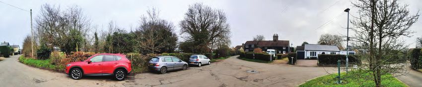
1.0 Introduction                                 2
Contents
           2.0 Designations and the NPPF                    3
            2.1 Conservation area                           3
            2.2 Statutory list                              3
            2.3 Local listing                               3
            2.4 Metropolitan green belt                     3

           3.0 Location and setting                         4

           4.0 Origins and development of the settlement    5

           5.0 Architectural character                      6

           6.0 Landscape characteristics and trees          9

           7.0 Significant views                           10

           8.0 Enhancement proposals and guidance          12

           9.0 Summary                                     13

           Appendices                                      14

            9.1 Listed buildings                           14

            9.2 Existing locally listed buildings          14

           Select bibliography                             14

                                                                Sleapshyde   1   Conservation Area Character Statement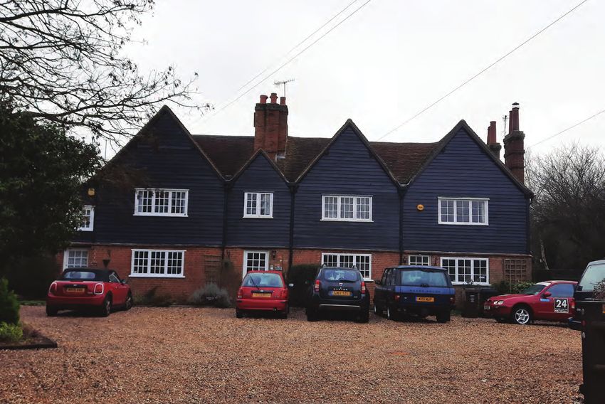
Figure 1: Map of the Sleapshyde Conservation Area
1.             1.1 The Civic Amenities Act 1967 first empowered local planning authorities
               to make provision for the preservation and enhancement of areas of
Introduction   architectural and historic interest by designating them as conservation areas.
               The Planning (Listed Buildings and Conservation Areas) Act 1990 is the
               current legislation that provides for the designation of conservation areas.
               Section 72 of this act sets out the general duty to pay special attention to
               the desirability of preserving or enhancing the character and appearance of
               a conservation area.
               1.2 Government policy is now contained in The National Planning Policy
               Framework (NPPF) and the National Planning Policy Guidance (NPPG).
               The Sleapshyde Conservation Area was designated in 1993.
               1.3 Conservation should not be thought of solely as a process of preservation
               and an impediment to change. The designation of a conservation area
               represents an opportunity to formulate positive policies to improve and
               enhance its environmental quality and to ensure the successful integration
               of any development or redevelopment necessary for its continued success
               as a living and working community. The St. Albans District City and District
               Local Plan Review (DLPR) - adopted November 1994 - sets out the general
               principles which will be observed when dealing with applications for new
               development and redevelopment.
               1.4 The aims of this Conservation Area Character Statement are to show the
               way in which the form of the conservation area has evolved and to assess
               its present character; to indicate the principles to be adopted in considering
               planning applications in the area; and to form a framework within which
               more detailed proposals may be formulated.

                                                                                                Key
                                                                                                  Grade II listed buildings
                                                                                                  Locally listed buildings
                                                                                                    Conservation Area Boundary
                                                                                                                                              © Crown Copyright and database rights 2020 Ordnance Survey 100018953

                                                                                  Sleapshyde    2     Conservation Area Character Statement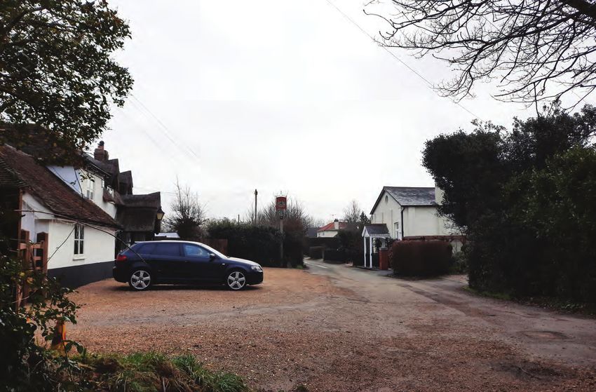
2.             Conservation Area
Designations   2.1 The Sleapshyde Conservation Area was originally designated on the 31th March 1993.
               The boundary of the conservation area has not been subsequently altered.
               Statutory List (Listed Buildings)
               2.2 ‘Listed buildings’ are buildings included on a list of “Buildings of Special Architectural
               or Historic Interest” compiled by central Government. They are classed as ‘designated
               heritage assets’. Listed buildings within the Conservation Area are given in the Appendix.
               All parts of the buildings are normally protected under the main listing, this may include
               outbuildings within the curtilage of the listed building, dependant on certain criteria. Listed
               buildings should not be confused with ‘locally listed buildings’, which are designated by the
               local planning authority (St Albans City and District Council), in consultation with the public,
               local amenity societies.
               Local Listing
               2.3 The Council considers those buildings which make a positive contribution to the
               character or appearance of the Conservation Area should be designated ‘locally listed’.
               The NPPF classes locally listed buildings as one type of ‘non-designated heritage assets’.
               Whilst it encourages local authorities to draw up local lists, the NPPF allows for any building
               the Council considers a ‘non-designated heritage asset’ to have its significance taken into
               account in planning decisions, whether or not it is on a local list. At local level, Saved
               Policy 87 of the DLPR (1994) is relevant. Saved Policy 87 provides protection for buildings
               the Council considers ‘worthy of local listing’ at any time, whether or not a formal list has
               been drawn up.
               2.4 Advice on assessing a building’s ‘significance’ is laid out in the NPPF; Historic England’s
               document ‘Conservation Principles’ (based on an asset’s evidential, historical, aesthetic or
               communal value); and most recently in Historic England’s ‘Local Heritage Listing – Advice
               Note 7’ published May 2016. This document emphasises the need for public consultation
               of the local list. It also states that “the absence of any particular heritage asset from the
               local list does not necessarily mean that it has no heritage value, simply that it does not           The 1896 ordnance survey map indicates the limited change that has occurred in the conservation area
               currently meet the selection criteria or that it has yet to be identified”.
               2.5 Within the St Albans District, ‘local lists’ have been mainly drawn up in conjunction with
               Conservation Area Character Statements, which are reviewed from time to time.
               2.8 The existing locally listed buildings are given in the Appendices, along with those added
               through this Appraisal. It should be noted that any building or structure can be locally
               listed, e.g. a wall, post box, gate or railing. However, a structure physically attached to; or,
               within the curtilage, ancillary to, and dated pre 1 July 1948, of a statutory listed building is
               already protected by virtue of that listing, and would not normally be locally listed in its own
               right. Exceptions to this may be, for example outbuildings, where ‘double’ designation may
               occur. The statutory listing will always override a local listing in this instance.
               Metropolitan Green Belt
               2.9 Sleapshyde is defined as a Green Belt Settlement, because it is set wholly within
               the Green Belt. As such any new development must meet national planning guidelines
               designed to protect the Green Belt.

                                                                                    Sleapshyde      3     Conservation Area Character Statement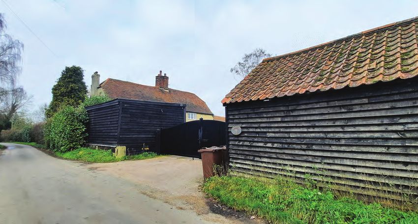
3.1 Sleapshyde lies between St Albans and Hatfield, immediately north of                                                                                       Figure 2: Open space analysis map
3.
              the A414 dual carriageway and close to the district boundary. To the north
Location      lies the Alban Way, the former railway line between St Albans and Hatfield.
and Setting   3.2 The conservation area covers the eastern, historic core of the hamlet
              which is arranged along three lanes radiating from a central green. The
              former chapel and public house, formerly the only public buildings in the
              hamlet are located on the northern lane, set away from the central green.
              To the west of the conservation area boundary lies some mid-C20 housing,
              which is more suburban in character.
              3.3 The wider setting of the conservation area is dominated by farmland to
              the north and east. Views of the Conservation Area’s agricultural setting are
              intermittent from the streetscene, which is relatively enclosed.
              3.4 To the north and east of the conservation area there are large, flat fields
              flanked by hedgerows and trees, and there are some views out across the
              fields in this direction, particularly from the Plough, from where the District
              boundary which runs along a leafy byway is visible across the fields. The
              north-western part of the conservation area is visible from Smallford Lane
              to the west, from where properties can be seen set behind mature gardens.
              The western part of the conservation area is separated from the residential
              area to the west by a playing field.
              3.5 The setting of Sleapshyde contributes substantially to the conservations
              areas significance. It contributes to the hamlet’s rural character and is an
              important part of its agricultural history. The surrounding farmland is also
              considered to be part of the setting for most of the designated and non-
              designated heritage assets within the conservation area.
              3.6 The North Orbital Road lies to the immediate south of the Conservation
              Area. The woodland in the south of the Conservation Area plays an important
              role in characterising the area providing a green setting to the south and
              helps reduce the impact of the road noise and inter-visibility between the
              two.
              3.7 The map analysis considered open space inside the conservation area
              boundary and where it formed its immediate context. Open space is defined
              as common land, farmland, countryside and recreational spaces (including
              school grounds, churchyards and cemeteries). Publicly accessible woodland
              is included within this definition. Private gardens and private car parks are
              excluded.

                                                                                                Key
                                                                                                    Open Space
                                                                                                    Woodland
                                                                                                    Sparse Woodland
                                                                                                    Conservation Area Boundary
                                                                                                                                              © Crown Copyright and database rights 2020 Ordnance Survey 100018953

                                                                                  Sleapshyde    4     Conservation Area Character Statement
4. Origins    4.1 Slaep is the old English for slippery or watery place and Hyde was a late
              Saxon word for the size of land farmed by one peasant family which was
and           usually 120 acres. It is probable that the ‘hyde’ in this area is associated with
development   the Abbey policy of the late C11 and C12. This policy allowed clearings of
              120 acres or more of formally forested land. The settlement is not mentioned
of the        in the doomsday book and therefore it is likely to originate from the 12th
settlement    century.
              4.2 In the Middle Ages, Sleapshyde was a small hamlet in the large manorial
              estate of Park, belonging to St Albans Abbey. The first reference to Slape
              is in the Abbots of St Albans Court Book which recorded the Abbots official
              dealings with tenants including marriages, inheritances and fines. The first
              reference refers to Reginald of Slape exchanging land in the C13 and makes
              reference to Roger and Agnes Slape’s family from 1273 through to the late
              C14.
              4.3 To the west of Sleapshyde, beyond Smallford Lane, the Abbey owned the
              fishing rights in Smallfordwater and there were occasional fines for poaching
              fish. One grandson of Robert Slape, Alexander, was frequently in court for
              felling trees and grinding his own corn, rather than using the Abbeys mills.
              In the C15 the Abbott granted land in Sleap to the hospital of St Anthony,
              London. From the C15 to the end of the C17 there are other documents
              which refer to members of the Sleape family and other inhabitants of Slape
              or Slepe.
              4.4 After the reformation the former monastery land were given by the
              crown to the Denny family. Nineteenth century census data for Sleep shows
              the main occupation of the population was in agriculture. Two farmers were
              listed but most occupants are categorised as agricultural labourers and                    The 1821 map of Sleapshyde, by T.Godman shows Sleapshyde Farm, and the surrounding buildings, including the
              a number of women and children made straw plait and hats. There is no                                                         Plough, Farm Cottage and some other buildings. Courtesy of HALS, 36068)
              mention of the surname Sleape by this time.
              4.5 The nineteenth century also saw the construction of the Methodists
              chapel in the hamlet in 1840. It is one of the earliest purpose built Methodist
              chapels in Hertfordshire. The chapel cost £210 to build and was designed to
              seat 108, enough for the whole population as the nearest parish church was
              St Peter, 4 miles away in St Albans. Though the local congregation fell when
              the church at Colney Heath was built, Methodists from Hatfield travelled to
              the church which allowed it to stay open until the C21.
              4.6 During the C20 some of the old farmers’ cottages were demolished and
              mostly replaced with bungalows. A number small of dwellings were built in
              the early part of the century from temporary materials and there has been
              some limited in filling in the hamlet centre.

                                                                                    Sleapshyde    5   Conservation Area Character Statement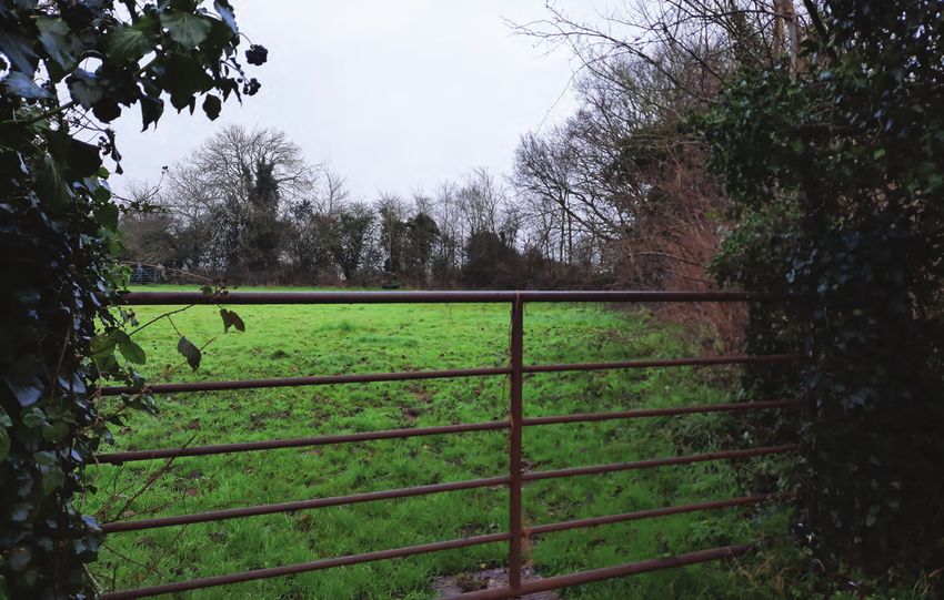
5.1 The conservation area is formed of Sleapshyde farm, a public house, the
5. former chapel, now converted, and a small number of dwellings. There is no
Architectural record of buildings surviving from the medieval period and most of the listed
buildings date to the C16-17. Several of the houses in the conservation area
Character date to the C20 and are not of any particular historic or architectural interest.
Except for a couple of notable exceptions the most of the C20 houses are
bungalows and this allows the historic buildings and landscaping to be more
visually predominant.
5.2 There is a mix of building materials within the conservation area, though
the predominant materials are plain clay roof tiles and natural slate, red/orange
brick, dark stained weatherboarding and white and natural coloured render.
5.3 The hamlet is scattered, radiating out from the central semi-circular green.
The density of development is low with no consistent building line, giving the
hamlet an informal character. The buildings are principally set back with no
footpaths so streetscene is dominated by hedgerows, punctuated with small,
mainly un-gated driveways.
5.4 Although the historic buildings are scattered informally around the hamlet,
they are visually bound together and enhanced by the network of greenery:
the open spaces, the hedges, the trees and gardens which overall provide an
attractive countryside feel which is an appropriate setting for the buildings.
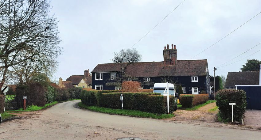
5.5 The only remaining public building in the hamlet is the Plough Public House.
It forms an important landmark building, marking the northern entrance from
the footpaths to the Alban Way and Wilkins Green. The Plough dates originally The Plough is a prominent building due to its thatched roof and more isolated location as the only building on the east
to the late C17, and its thatched roof with dormers and large red brick external side of the northern lane.
chimney stack distinguish it from the rest of the buildings in the Conservation
Area. In the C19 there was a shop attached which has since been incorporated
into the public house. The rear modern extensions are fortunately subservient
in height, despite their incongruous footprint and design.
5.6 The Plough is visible from the paddock and the pond to the west of the
central green which gives the public house an open setting. The publican used
to farm the adjacent field until the C19 and this strengthens the association
between the public house and the adjacent land. The paddock and pond are
surrounded by hedging and trees including the road frontage. These open
spaces are important elements which contribute to the rural character of the
hamlet.
The paddock runs adjacent to the north lane and provides greenery in the centre of the conservation area and was
historically known as the collect
Sleapshyde 6 Conservation Area Character Statement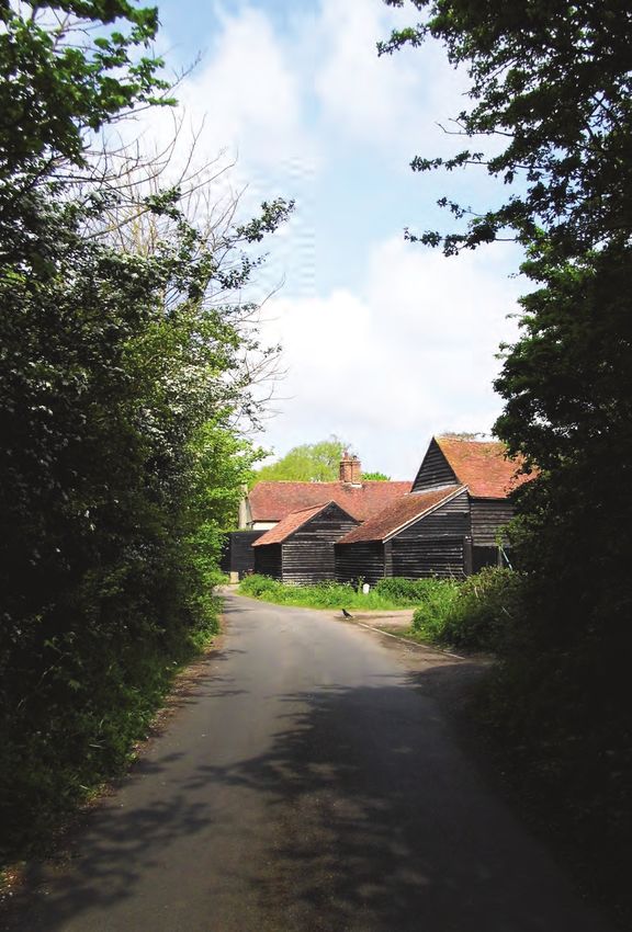
5.7 Opposite the Plough is one of the two other formerly
5.              public buildings, the former Methodist chapel. The chapel
Architectural   is a prominent, but simple building. The front facing gable,
                taller rear gable, chimney and slender piers to the front
Character       elevation emphasises its verticality, differentiating it from
                the rest of the conservation area. The form of the building
                with the front facing gable, double timber doors, attractive,
                well detailed porch and railings have been retained
                making its former function clearly legible. Unfortunately
                the historic paving to the front elevation was lost in the
                conversion. The construction and use of the chapel in
                the C19 is an important part of the historic interest of the
                hamlet. In 1907 the church extended to the rear to create
                a club room, as an alternative venue for the Plough PH
                opposite.
                5.8 The central green itself is small and is surrounded by
                the road and curbed in granite. On the green is the former
                village water pump, (minus its handle) and the small oval
                village sign on a fluted column, which was previously the
                light column. The recently installed modern streetlight and
                telephone mast are unfortunately prominent additions
                which clutter the small green and draw attention away
                from the historic street furniture.
                                                                                                                Farm cottage              The former Methodist Chapel retains its simple but distinctive elongated form
                5.9 Farm cottage is hidden behind the pond and central                                                                                                                      indicative of its former use
                green, up a long gravelled driveway. The building is a late
                C17 timber framed cottage, re-fronted in the late C19 to
                early C20. The Cottage has open views out towards the
                Plough, Sleapshyde farm and the surrounding agricultural
                landscape. Now in a relatively isolated position, the
                building used to sit on the north-eastern end of the central
                green, as shown in the 1820s map on page 5.

                                                                                                   The central green retains some historic street furniture. Unfortunately the fluted column to the former C19 light post
                                                                                                                           has been used for attaching other signs at a high level which detracts from its appearance.
                                                                                Sleapshyde   7   Conservation Area Character Statement
5.10 To the south of the green lies Sleapshyde farm, which marks the
5.              entrance to the hamlet from the south. Sleapshyde Farm is visible
Architectural   above the hedgerow and forms an important part of the streetscene.
                Opposite lies a curved brick wall to the rear of Rose cottage. South
Character       lane is narrow and lined with high hedges which, combined with the
                farmyard, gives the south lane an enclosed and very rural character.
                5.11 Sleapshyde Farm formed of the Farmhouse, three barns,
                stables and a granary arranged around a traditional farmyard. The
                Farmhouse is a former hall house and thought to date to the early
                1500s, and is the oldest surviving building in the hamlet. The large
                C17 barns and late C17-18 granary are timber weather boarded with
                clay plain tiles and have a traditional and attractive appearance. The
                buildings contribute to the rural character of the hamlet emphasise
                its historic agricultural origins.
                5.12 Rose cottage and Little Rose Cottage sits opposite Sleapshyde
                Farm and comprise of one long range, a pair C17 cottages. The
                building has a typical vernacular appearance with weatherboard,
                small features and a clay plain tile roof. Despite being set back and
                at an angle to the central green, Rose cottage is the most prominent
                building in the centre of the hamlet. This is due, in part to its dominant
                central chimney stack of two tall square shafts.
                                                                                                    Although a little too tall, the 1980s side extension to Rose Cottage relates well to the original building by using similar weatherboarding
                                                                                                                                                                                                                              and clay roof tiles.

                                                  Sleapshyde Farm is a historic farmstead dating to the 1500s and the clay tiles and weatherboarding unify these buildings. Sleapshyde Farmhouse is one of the most prominent buildings.

                                                                                          Sleapshyde         8       Conservation Area Character Statement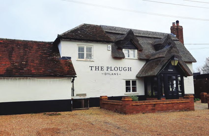
5.                5.13 The character of the lane to the west of the central green acts as a
                  transition between the C20 housing development and the historic centre
Architectural     of the hamlet. The transition is defined by the both the buildings and the
Character         streetscene, as the suburban form of grass verges and pavements changes
                  to a narrow lane with no footpath and un-kerbed, front boundaries.
                  5.14 Angel Cottage, a former beer house, marks the start of the conservation
                  area. The buildings white render, welsh slate roof and well-proportioned
                  Victorian features make it a conspicuous and attractive feature on the
                  streetscene.
                  5.15 Opposite, the start of the scrub land to the south of the hamlet marks the
                  southern boundary of the conservation area and encloses Ye Olde House,
                  framing its attractive four gabled frontage. The mid-C17 timber framed
                  house is now three cottages. Its predominant external features are its plain
                  clay tiled roof, weather boarded upper floor and the large mid seventeenth
                  century red brick chimney stack. When it was restored in residential use
                  in the late 1980’s, a barn like garage, in traditional materials was erected
                  within a gravel driveway.
                  5.16 Most of the other buildings in the conservation area are interwar and
                  later in date. This development is no particular architectural or historic
                  interest. The housing is generally considered to have a neutral impact
                  because for the most part they are reticent as they are set quite low, only
                  1-1.5 storeys in height. The low height of the new development allows the
                  more historic and architecturally interesting buildings to be more prominent.
                                                                                                                              Ye Olde House has a striking row of gable ends which mark the start of the historic hamlet.

6.                6.1 Although the buildings are scattered informally around the hamlet,
                  they are visually bound together by the network of greenery which provides
Landscape         a consistency to the streetscene. The open spaces, hedges, trees and
                  gardens creates an attractive countryside feel, providing an appropriate
Characteristics   setting for the buildings. This green character is an essential element of the
                  conservation area and the hedgerow and trees gives the lanes an enclosed
                  atmosphere.
                  6.2 Although the trees within the conservation area are not generally large,
                  most properties have substantial boundary hedges which include privet,
                  beech, holly, and elm species.
                  6.3 All trees within a Conservation Area above a certain size have automatic
                  protection, whether or not they are covered by a TPO, and permission must
                  be sought from the Trees and Woodlands section of St Albans City and
                  District Council before the lopping, topping, pruning or felling of any trees
                  other than fruit trees.

                                                                                                                                        Angel Cottage’s form and proximity to the street is reflective of its former use as
                                                                                                                                                                                                              a beer house.
                                                                                      Sleapshyde    9   Conservation Area Character Statement
7. Sleapshyde is characterised by the relationship between the village, the street Key
and the surrounding rural landscape. The significant views, discussed in detail
Significant below, illustrate aspects of the character and appearance of Sleapshyde which
Point view
Panoramic view
Views are considered to be of special architectural and historic interest.
Static
Views can be static or dynamic, and of certain specific features or of wider town Dynamic
or landscapes. Due to the enclosed nature of the streets on the conservation area
and pattern of settlement, many of the views in Sleapshyde are of points, Conservation Area
framed by the trees and hedgerows. The map to the right is annotated to Boundary
describe the type of view and its location.
2
3
1
View 1: Sleapshyde Farm
This is the first view of the
conservation area when entering
from the south. Sleapshyde
Farm comes into view between
the high hedgerows. The
Farmhouse was one of the
higher status buildings in the
area. Most of the buildings pre-
date the 19C and the view has
changed little in the past couple
of centuries.
Figure 3: Significant views map © Crown Copyright and database rights 2019 Ordnance Survey 100018953
Sleapshyde 10 Conservation Area Character StatementView 2: North entrance to Sleapshyde
7.
Significant The Plough and the Methodist Church mark the north entrance to the
Hamlet, accessed from the footpath which links to the Alban Way and the
Views former Smallford Station. The view has changed little since the mid-C19
when the Methodist Church was built and shows the characteristic
materials boundaries and building layout of these two former public
buildings.
View 3: The Central Green
The green forms the centre of the historic hamlet. The view demonstrates some of the key
characteristics of the conservation area. The view shows informally scattered historic buildings
around the green, visually bound by the network of greenery: the open spaces, the hedges, the
trees and gardens which overall provide an attractive countryside feel which is an appropriate setting
for the buildings.
Sleapshyde 11 Conservation Area Character Statement8. 8.1 To preserve or enhance the hamlet’s historic character Key:
and appearance, it is important that any development Original building use
Enhancement is of a high standard of design, sympathetic to its Public
proposals & surroundings and the conservation area as a whole. It Residential
should not detract from the setting of nearby existing
guidance buildings, its form should have regard to the surroundings Agricultural
and the existing balance of buildings and landscape, and Road
should be of good quality, normally traditional and natural Public frontages
materials. Residential frontages
8.2 The form of development in Sleapshyde is informal,
with buildings scattered along lines radiating out from
the central small green. The inconsistent, but set back
building lines are an essential part of the rural character of
the hamlet. The main exceptions to the setback building
line are the Plough and the other former public buildings:
the former Methodist Church, and Angel Cottage, the
former beer house. Future development should maintain
the setback building lines to preserve the rural character
of the conservation area and the important distinction in
building types.
8.3 The height of new development needs to respond
to views in the conservation area in order to preserve
the prominence of the designated and non-designated
heritage assets. Figure 4: The map shows the historic, original building uses within the Conservation Area and their relationship to the street
8.4 The green and rural character of the hamlet is an
essential part of the character and appearance of the
conservation area. The hedgerow, trees and gardens
visually connect the otherwise dispersed development
and the existing balance between built form and the
landscape should be maintained.
8.5 Sleapshyde has a variety of materials, though most
are traditional. The predominant traditional roofing
material in the area is plain clay roof tiles for the high
pitched timber framed buildings and natural slate for the
lower pitches of the nineteenth century buildings. Walling
is predominantly dark stained weatherboarding for some
cottages and agricultural buildings. Some have natural
render/external plaster, although some render has been
painted white. Historically, brickwork has been used for
chimneys and as plinths or ground floors.
8.6 Some of the recent buildings have natural or painted
rendered walls which creates some unity with the historic
buildings, but some are brick faced with modern roofing
materials including some profiled sheeting and plain or
profiled concrete tiles, on generally low pitched roofs. A
proliferation of non-unifying materials should be avoided.
Compilation of traditional building materials located throughout the conservation area
Sleapshyde 12 Conservation Area Character Statement8. 8.7 The traditional windows are timber, with a painted finish, normally white.
Most are casements and many are multi-paned. Angel Cottage has more
Enhancement typically nineteenth century sash windows. Dormer windows are found at
proposals & the Plough but are not a characteristic of the hamlet. uPVC windows and
doors lack the details of traditional joinery, have a more reflective finish
guidance and are generally not as long lasting as traditional timber windows. They
should be avoided and will not be acceptable for listed buildings and new
development. Replacement windows in an unlisted existing dwelling may
constitute permitted development, but their use is discouraged in order to
preserve the traditional appearance of the hamlet.
8.8 The boundary treatments are generally informal in appearance
and hedges, scattered trees, and post and rail fencing and gardens are
predominant. The hard un-kerbed road edge with no footpath is also an
important characteristic of the streetscene and this helps differentiate the
conservation area from the mid-C20 more suburban development to the
west.
8.8 Development should follow these characteristic boundary treatments
and avoid over formal or aggrandising entrances, fences and sub-urban
and overly ornamental forms of planting and landscaping. It is important
to avoid introduction of highway kerbing wherever possible, and the hard
surfacing of driveways, which are currently mostly loose gravel, to help
maintain the rural character of the hamlet.
The area of woodland to the south-east of the conservation area reduces the noise impact and invisibility of the North Orbital
on the Conservation Area
9.1 It is the Council’s aim to encourage retention of those features which
9. make the Conservation Area special – not just historic buildings and their
architectural features, but their settings and boundary features – historic
Summary walls, fencing, and hedges. Every effort should be made to maintain
important landscape features and the existing balance of buildings and
landscape
Typical hedgerow and un-kerbed road in Sleapshyde Tree and hedgerow lined footpaths and roads give the hamlet a rural and enclosed character
Sleapshyde 13 Conservation Area Character Statement10.0 STATUTORY LISTED BUILDINGS SELECT BIBLIOGRAPHY
Appendices The list descriptions can be found on www.historicengland. Tomkins. M. (Unknown) ‘The Plough and the Chapel’.
org.uk or through the St Albans District Mapping Service. Tomkins. M. (1981) ‘The Manor of the Park in the 14th
Names and spellings are as per the list descriptions: Century’. Hertfordshire Publications. Hartford
Grade II Page. S.F (1960) ‘Sleapshyde’ Herts Countryside. Vol 14
• The Plough Inn, Sleapshyde Lane p103.
• Farm Cottage, Sleapshyde Lane Colney Heath Parish Council. (1994) ‘Colney Heath Parish
• Sleapshyde Farmhouse, Sleapshyde Lane in Times Past’. Colney Heath Parish Council.
• Granary to South East of Sleapshyde Farmhouse, Page. W (1907) ‘A History of the County of Hertford:
Sleapshyde Lane Volume 2’. Victoria County History. London
• Range of Two Barns and Adjoining Stable, South East The National Archives (1841) ‘Census Records,’ National
of Sleapshyde Farmhouse, Sleapshyde Lane Archive Reference: HO 107
• Rose Cottage and Little Rose Cottage, Sleapshyde
Lane
Historic Map references are contained within the image
• Ye Olde House, 1, 2 and 3 Sleapshyde Lane
caption
LOCALLY LISTED BUILDINGS
The following buildings are included on the local list and
are non-designated hertiage assets:
• Methodist Chapel, Sleapshyde Lane
• Angel Cottage, Sleapshyde Lane
Sleapshyde 14 Conservation Area Character StatementSTATUS OF THIS DOCUMENT This Conservation Area Character Statement was adopted on 03/08/2021. Public consultation took place on this document between 18 January 2021 to 01 March 2021. Consultation responses have been considered and, where appropriate, incorporated into the final document. This document should be read together with saved Policy of 85, 86 and 87 of the St Albans City and District Local Plan Review 1994. It has been produced as part of DPR Project 9: Policy Statements - Conservation Areas and includes locally listed buildings For more information please contact the Council at: Planning Policy St Albans City and District Council St Peter’s Street St Albans AL1 3JE Telephone: 01727 866100 Email: Planning.Policy@stalbans.gov.uk Website: http://www.stalbans.gov.uk If you require this information in another format e.g. in large print, Braille, audio or in another language other than English, please contact the Equalities Officer on 01727 814602 or email equalities@stalbans.gov.uk
You can also read