Small Towns in KwaZulu-Natal: Assessing their 'Tourism Readiness' - Phase 1: Report
←
→
Page content transcription
If your browser does not render page correctly, please read the page content below
Small Towns in KwaZulu-Natal:
Assessing their ‘Tourism Readiness’
           [Phase 1: Report]

                                       Richard Wyllie
                                          Researcher
                               Tourism KwaZulu-Natal

                                    September 2017
CONTENTS

List of Acronyms                           3
List of Definitions                        4

1. Introduction                            6
2. Aim of the Study                        7
3. Methodology                             7
4. Small Towns Analysis                   10
        4.1. Town 1: Howick               10
        4.2. Town 2: Nottingham Road      13
        4.3. Town 3: Winterton            16
        4.4. Town 4: Dundee               20
        4.5. Town 5: Mtunzini             22
5. Summary of Findings                    25
6. Recommendations and Way Forward        27
7. Conclusion                             28

References                                29

Appendix 1: Fieldwork Notes               32
Appendix 2: List of Towns/Cities in KZN   45
Appendix 3: Fieldwork Photographs         49

                                           2
List of Acronyms
ABW Anglo-Boer War
AOP Annual Operational Plan
APP Annual Performance Plan
ATM Automated Teller Machine (Cash Withdrawal)
EDTEA Economic Development, Tourism and Environmental Affairs (KZN)
KSIA King Shaka International Airport
Km(s) Kilometre(s)
KZN KwaZulu-Natal
KZNTA KwaZulu-Natal Tourism Authority
MM Midlands Meander
MTB Mountain Bike
N3GTA N3 Gateway Tourism Association
PMB Pietermaritzburg
POE Portfolio of Evidence
SAFE South Africa Far East
Stats SA Statistics South Africa
TD Tourism Development
TKZN Tourism KwaZulu-Natal
UNESCO United Nations Educational, Scientific and Cultural Organisation
WESSA Wildlife and Environmental Society of South Africa
3List of Definitions
Apartheid An ideology, supported by the National Party (NP) government, which was
introduced in South Africa in 1948. It called for the separate development of
the different racial groups in South Africa. The word was Afrikaans for
“apartness”.
Avitourism A form of tourism that focuses on local birding opportunities. Avitourism is one
of the fastest growing types of environmental tourism, or ecotourism.
Battlefield The piece of ground on which a battle is, or was, fought.
Day Visitor A visitor who travels to a destination for less than one night (24 hours) and
does not stay overnight – i.e. returns home after the trip on the same day.
City A city would have abundant services, but not as many as a large city. The
population of a city is between 100,000 and 300,000 people.
Municipality A primarily urban political unit having corporate status and usually powers of
self-government.
Overnight Visitor A visitor who travels to a destination for more than one night (more than 24
hours). They do not return home on the same day as their trip.
Town (Large) A large town has a population of 20,000 to 100,000 people.
Town (Small) A town has a population of 1,000 to 20,000 people.
Sangoma A traditional healer who are practitioners of traditional African medicines
within Southern Africa. Sometimes referred to as ‘witch doctors’.
Tourism Comprises the activities of persons travelling to, and staying in places outside
their usual environment, for not more than one uninterrupted year, for leisure,
business and other purposes. The usual environment of a person consists of a
certain area around his/her place of residence, plus all other places he/she
frequently visits.
Twitcher An avid bird-watcher or an ‘Avitourist’. Someone who travels outside of their
place of residence for the chance of watching birds, most of the time it includes
spotting a rare or unique species.
Village A village is a human settlement or community that is larger than a hamlet but,
smaller than a town. A village generally does not have many services, most
likely a church or only a small shop or post office. The population of a village
varies, however, the average population can range from hundreds to
thousands.
4Visitor Any person travelling to a place other than that of his/her usual environment
for less than 12 months and whose main purpose of the trip is other than the
exercise of an activity remunerated from within the place visited.
Voortrekkers The Voortrekkers (Afrikaans and Dutch for ‘pioneers’, literally "fore-pullers",
"those in front who pull") were Boer pastoralists from the frontiers of the Cape
Colony who migrated eastwards during the Great Trek (1835-1846).
51. Introduction
This study is primarily focussed on assessing the so-called “tourism readiness” of ten small towns (by
definition) in KwaZulu-Natal (KZN). This report is considered as Phase 1 of the study in which five
towns were selected and analysed. These towns include Howick, Nottingham Road, Winterton,
Dundee, and Mtunzini. The further five towns, for Phase 2, have not yet been selected at this point.
Figure 1 shows the location of the five towns that were selected for this study along with other
important features, such as the major highways that feed to the towns.
Figure 1: Map of KZN
Source: Rooms For Africa, 2017
This study was formed based on a request by one of the Board members of Tourism KwaZulu-Natal
(TKZN), or the KwaZulu-Natal Tourism Authority (KZNTA). This member of the Board put forward the
names of the first five towns, and thus this request was honoured in the writing of this report.
The reason behind this request is based on the fact that many tour operators pass through various
towns in the province, on their way to some of the main destinations, and some of them have noted
6that there are a number of “hidden gems” that are being missed while passing through in the area.
In addition to this, they also noted that some of the towns are lacking in certain aspects, or others
are in need of improvement in order for such small towns to be attractive to or ready to receive
tourists. These include a lack of proper signage, poor road conditions, or insufficient facilities.
1.1. Background and Context
KwaZulu-Natal, which is located on the east coast of South Africa, offers tourists a wide variety of
places to visit, things to do, and destinations to see and experience. There is a total of two UNESCO
World Heritage Sites which are found in the province – the iSimangaliso Wetland Park (natural
heritage), and the uKhahlamba Drakensberg Park (mixed heritage).
There are, however, a large number of other attractions and activities in the “Zulu Kingdom” which
attract a large number of foreign, and domestic, tourists year after year. Many of these destinations,
and activities, are unknown to these visitors and are thus considered to be “hidden gems”. In other
words, there are various attractions, towns, or activities that are on offer in the province but are not
well supported due to various factors, such as that they are not well marketed, or they are in an area
that doesn’t attract a large number of visitors as visitors may well be unaware of attractions
associated with those destinations.
There are many unique experiences that can be found in KZN, many of which are “off the beaten
track” in the more rural areas, or are located in close proximity to what is referred to as a “small
town”. One such example of this is the Palm Nut Vulture Trail which is found in the Umlalazi Nature
Reserve, in the town known as Mtunzini. Visitors (especially avid bird watchers or ‘twitchers’) have
the chance of spotting a very rare bird known as the Palm Nut Vulture. Another example would be
the historical Nottingham Museum which displays the history of Fort Nottingham, and it was also
the home of the annual KZN Highland Games – this can be found approximately 15 minutes outside
the town of Nottingham Road.
2. Aim of the Study
The overall aim of this study is to explore means of increasing the geographic spread of tourism
throughout KZN and particularly into the more rural areas. This could be done through the
identification of a number of small towns which, though showing some possibilities to be developed
as tourism destinations, require certain assistance, upgrading, support or developments, in order to
realize that full potential.
3. Methodology
This study has been conducted by using both primary and secondary research methods. The
secondary research was made up of extensive desktop research whereby various websites,
brochures, and books were consulted. In terms of the primary research, fieldwork was conducted
whereby the researcher travelled to each of the five towns (included in this study) and, through
thorough observations and exploration, compiled notes based on the trips. A “checklist” for each
town was drawn up, with the assistance of TKZN’s Tourism Development (TD) department, prior to
the fieldwork. This checklist allowed for extensive observations to be made based on all aspects
relating to tourism in the selected town.
7The fieldwork took place on the Tuesday, the 11th and Wednesday, the 12th of July 2017 (Howick,
Nottingham Road, Winterton, and Dundee), as well as on Thursday, the 20th of July 2017 (Mtunzini).
All notes from the fieldwork has been compiled and outlined in the various tables in Appendix 1. The
original fieldwork notes (hand-written) will be submitted as part of the documents required in the
Portfolio of Evidence (POE). The POE should require such documents in order to prove that actual
fieldwork was conducted for this study and to substantiate the fact that budget was used for this
work. A couple of the photographs that were taken during the fieldwork have been attached in
Appendix 3 of this report. For the POE, there are electronic versions available which include the geo-
tag data as well as the date on which the picture was captured.
The same methodologies and processes will be followed in Phase 2 of this study.
3.1. Research Outline
Identify 10 ‘small’ towns in KZN, spread throughout the province, which have the potential to
become attractive tourism destinations. Phase 1 will include 5 towns, and Phase 2 will include 5
towns.
By definition (Stats SA), such ‘small’ towns should house a population of less than 20 000 people.
These towns should have an identifiable Unique Selling Point – an attraction (natural, cultural,
man-made), or an activity which could be developed further in some manner so as to draw
tourists to the area, or even the quaintness of the town itself.
Assessments are required of the following, as regards the town itself:
o Access, in terms of tar roads, rail links, air links
o Signage indicating directions to the town, and also to the attraction/s, as well as to
accommodation venues
o High level of cleanliness – no litter, no graffiti, clear verges, municipal areas and sidewalk
areas displaying cut grass, flowers
o Lack of visual clutter – no large signs (advertising, political posters), no out of date
posters, no illegal signs on poles, in public areas
o Basic services – potable water availability, electricity availability, internet connectivity
o Street lighting for aesthetic and safety purposes
o A variety of accommodation options – listed, with size, grading, and pricing
o A variety of food and beverage options – listed, with size, grading and pricing
o An information office
Assessments are also required of any attractions/activities associated with each town:
o Access to the site/s – easy, safe, tarred
o Signage, to and around the site itself
o Facilities available at the site itself – ablution facilities, potable water, a tea
room/café/refreshment stand, memorabilia, trained and registered tour guides
o Site needs to be clean – no litter, no graffiti, no vandalism
o Site needs to be safe – is there a site manager or someone who is responsible for
maintenance?
Background needs to be provided on each town – history, attributes etc.
Three of the towns with the greatest potential for development as tourist towns or towns which
could attract tourists, need to be highlighted (end of Phase 2). This would also need to be
discussed with the tour operators to make sure that this is what they require as well.
8 A development plan for each one needs to be drawn up - outlining what is required to enable
the town to be 100% tourist-ready. This would largely consist of a list of recommendations,
prioritized according to level of importance, and the effect of complying with each (end of Phase
2).
Marketing and promotions plan needs to be drawn up to promote the town (end of Phase 2).
Information on the town needs to be provided to travel agencies, tour operators, on websites, to
and via the local tourism agency (end of Phase 2).
Monitoring of the performance (level of success in terms of increased tourism flow to/through
the town) also needs to be done. This can be achieved through the collection of monthly
occupancy data from the accommodation establishments, and visitor statistics from the
attractions/monuments/ museums/activities in/linked to the town (end of Phase 2).
3.2. Outline of the Study
This report will include a detailed outline of each of the five towns that will look at aspects such as
introductory note (climate, location, etc.), the history of the town, profile of the town, and the
current state of tourism (e.g. number of attractions, restaurants, and accommodation). A detailed
summary for each town is also provided in the section that follows. In addition to the above, the
original fieldwork notes have been included in Appendix 1 for further reference.
94. Small Towns Analysis
4.1. Town 1: Howick
4.1.1. Introduction
Howick is located in the Pietermaritzburg/Midlands region of KwaZulu-Natal (KZN) and is
approximately 88 kilometres from Durban, and about 25 kilometres from the capital city,
Pietermaritzburg (PMB). It is located in the uMgeni Municipality, which forms part of the
uMgungundlovu District Municipality, and it is found at 1 050m above sea level. The town is found
along the N3 highway, that connects Durban with Johannesburg, and it is easily accessible from
three separate turn offs along this road (Umgeni Municipality, 2017). It also forms part of the
Midlands Meander (MM) which is a well-known tourism route which stretches from Cedara (Hilton)
all the way through to Giant’s Castle in the Drakensberg (Midlands Meander Association, 2017).
Figure 2: Map of Howick
Source: Google, 2017
The weather in Howick is often very pleasant, but the winters can be quite cold – especially when
there is snow falling in the area and on the Drakensberg Mountains. Howick receives an average of
843mm of rain per year, with most rainfall falling mainly during mid-summer (Dec-Jan). It receives
the lowest rainfall (5mm) in June and the highest (141mm) in January. The average midday
temperatures for Howick range from 18.9°C in June to 25.8°C in February. The region is the coldest
during June when the mercury drops to 4.1°C on average during the night (SA Explorer, 2014).
In 2011, the population was measured to be in the region of 21 639 people within a total area of
29.32 km2, thus making the population density 740 people per km2 (Stats SA, 2011). By definition,
10Howick is thus considered as a “large town” - however it is still included in this study due to the
request from a KZNTA Board member.1
The main population groups for Howick are outlined in Table 1 below:
Table 1: Population Groups in Howick
Black 47.0%
White 35.1%
Indian 13.5%
Coloured 4.1%
Other 0.3%
Source: Census, 2011
4.1.2. History of the Town
The town was established in November 1850 following a course of events from the 1840s onwards
(Wikipedia, 2017). During the 1840s, travellers moving north from Pietermaritzburg crossed the
Umgeni River, just west of the present-day Howick, at the Alleman's Drift. In 1849, Wesleyan
Missionary James Archbell (a Wesleyan Missionary) bought three farms above the northern bank of
the Umgeni River (Wikipedia, 2017). At that time, the town was referred to as "The Village on the
Umgeni Waterfall". This is shown on some of the original title deeds of the original plots.
In 1850, the river crossing was moved to the dangerous but more convenient spot at the top of
Howick Falls. This site was less than 200 metres from where the river plunged over the cliff's edge
and it was a very treacherous spot for the settlers. With the increase in migrations to the north (i.e.
the “Transvaal”), the National Government decided to establish a village at the crossing, and in doing
so they purchased part of James Archbell's farm. In November 1850, a declaration appeared in the
Natal Government Gazette, offering 36 village plots on the ‘Umgeni Waterfall Drift’ for sale. This
marked the official beginning of the town (Wikipedia, 2017).
In choosing a name for the new town, the Government officials decided to honour their Secretary of
State for the Colonies in London. The Secretary of State at the time was Earl Grey, and he had
recently acquired the title of ‘Lord Howick’. The name derived from his ancestral home of Howick
Hall in Northumberland, England. There were also two other towns that were named "Howick" at
the same time - one in New Zealand, and the other was in Ontario, Canada (Wikipedia, 2017).
During the Anglo-Boer War (1899 – 1902), the British had established a concentration camp on the
outskirts of the town. A monument, to the women and children who died during their incarceration
in the camp, still stands today and it marks the location of this camp.
Not many people are aware that Howick (more specifically Karkloof) is considered to be the possible
location of the first manned flight in the world. Some of the evidence that exists suggests that a man
known as John Goodman Household flew a self-made glider in 1871 and again in 1875 on the
outskirts of Howick, close to Karkloof. The actual distance flown, and altitude achieved, differs from
source to source but the distance that was flown is confirmed as being further and the duration also
longer, than either of the flights made by Lilienthal or the Wright brothers. It is said that a memorial
1
A ‘large town’ has a population of 20,000 to 100,000, while a ‘town’ has a population of 1,000 to 20,000.
11to Household's achievement can be found at Curry's Post, a small distance outside Howick (Tracks 4
Africa).
In the 1970s, The Umgeni Valley Ranch (Nature Reserve) was established on the, then, outskirts of
Howick by the Wildlife and Environment Society of South Africa (WESSA). WESSA was responsible for
the introduction of game into the area, such as zebra and wildebeest, and they also developed a
number of huts for overnight accommodation (WESSA, 2017).
The town also plays a major role in the history of South Africa, and more specifically the history of
Apartheid and the rise of democracy in the country. On the 5th of August 1962, the late former
president, Nelson Mandela, was arrested just outside of the town along the R103. This road
stretches from Howick to Nottingham Road, and beyond, and it was the former main road that
travellers took from Durban to Johannesburg (The Capture Site, 2017). This historical event was then
commemorated by a small plaque on the side of the road, but it has since been revamped and
developed into a large-scale monument and museum site known as the ‘Nelson Mandela Capture
Site’. In December 1996, some 34 years after his arrest, Nelson Mandela was awarded "The Freedom
of Howick" (The Capture Site, 2017).
4.1.3. Profile of the Town
This historical town has been shaped and transformed by many historical events and developments
over the years and it is now a town with real potential for further tourism development and growth.
As it stands, the town thrives on the many retirement villages and facilities, and there are no less
than five major retirement complexes existing along the Karkloof Road, in the vicinity of the Umgeni
Valley Nature Reserve. Complimenting these ‘estates’ are a number of other facilities, such as the
Howick Private Hospital. The town also thrives on the numerous agricultural activities that surround
it, with some major dairy farms and timber plantations contributing to the growth of the local
economy. Tourism is also another major economic driver, and this is discussed further in the section
below.
4.1.4. State of Tourism Readiness
As mentioned before, not only is the town situated on the N3 highway which forms part of the N3
Gateway Tourism Association (N3GTA), but it is also along the Midlands Meander route and is one of
the first major towns along the way. The history of the town has the potential to drive tourism on its
own, but the natural resources and modern developments have also helped to grow the town’s
tourism potential.
As previously mentioned, the history of the town is a major role player in the development, and
growth, of tourism within the local community. First of all, the Nelson Mandela Capture Site (or
commonly known as ‘The Capture Site’) is probably the most significant and prominent attraction, in
the vicinity of the town, that is responsible for attracting a large number of both foreign and local
tourists. In 1962, on the 5th of August, this otherwise ordinary piece of road along the R103,
approximately 5km outside Howick, was suddenly transformed into a site upon which history would
be made (The Capture Site, 2017). Armed ‘apartheid’ police flagged down a car in which Nelson
Mandela was pretending to be the chauffeur. After having successfully avoiding capture by
apartheid operatives for 17 months, it was in this dramatic way, at this unassuming spot, that Nelson
12Mandela was finally arrested. As one of the most historically important moments in the struggle
against Apartheid, a more appropriate and exciting marking of the site was needed. The site,
sculpture, and the (apartheid satellite) museum were officially opened to the public on the 4th of
August 2012, by President Jacob Zuma (The Capture Site, 2017).
Another site/attraction with historical significance, although not in the same ‘league’ as the Capture
Site, is the Anglo-Boer War memorials that are found just off of the main road through the southern
area of the town (near to Merrivale). As mentioned above, the monument stands as a memorial to
the women and children who died during their imprisonment in the concentration camp that stood
in this area of the town.
In addition to these historical attractions, the town is also famous for its natural attractions and
beauty. The Howick Falls, which is a 95 metre cascade of water, is one of the landmark features in
the town (SA Venues, 2017). The local Zulu name is KwaNogqaza, which means the “place of the tall
one”. This beautiful falls are regarded by the local Zulus with grave superstition, and it is said to be
the place of the spirits of ancestors. Further to this, local legend believes that a giant snake-like
creature lives in the main pool lives and only ‘Sangomas’ are regarded to be safe when standing
close to the falls (SA Venues, 2017).
Other prominent natural attractions are the Umgeni Valley Nature Reserve, and the Karkloof Valley,
The Umgeni Valley Nature Reserve, which is the home of the Wildlife and Environmental Society of
South Africa (WESSA), offers visitors comfortable self-catering accommodation and a wide range of
hiking trails (WESSA, 2017). The Karkloof Valley (approximately 10 minutes outside of Howick) boasts
a wide range of activities for both foreign and local tourists. First of all, the well-known Karkloof
Canopy Tours are located here and this attraction allows visitors to explore the lush canopy-topped
forests of Karkloof. Visitors are given their own safety gear and are assisted in ‘swinging’ from
various platforms for at least two hours (Karkloof Canopy Tours, 2017). The Karkloof Sappi MTB Trail
network is also a popular attraction, and is growing day-by-day in terms of development and visitor
numbers. Visitors can report to the Karkloof Country whereby they will pay a small fee to make use
of the trails – either for mountain biking, trail running, or simply taking a short walk amongst the
natural beauty (Karkloof MTB Trails, 2015). The Midmar Dam and Nature Reserve is another popular
spot for water sports and other leisure activities (KZN Wildlife), and the annual Midmar Mile – which
is one of KZN’s flagship sporting events (Midmar Mile, 2017).
There is plenty on offer within, and surrounding the town, and visitors are truly spoilt for choice with
additional attractions and activities found further along the Midlands Meander. In terms of its
attractions, Howick is considered to have a high rating in terms of its tourism ‘readiness’ – see
Appendix 1 for further discussion.
4.2. Town 2: Nottingham Road
4.2.1. Introduction
The small town of Nottingham Road is found along the Midlands Meander, on the R103 that runs
from Howick all the way to Mooi River and beyond. It is situated 59 kilometres from
Pietermaritzburg and 19 kilometres from Mooi River (via the R103). The town is also located in the
13uMgeni Municipality, which forms part of the uMgungundlovu District Municipality (the same as
Howick) (Wikipedia, 2017).
Figure 3: Map of Nottigham Road
Source: Google, 2017
The weather in Nottingham Road, similar to Howick, is considered to be very pleasant. The town
normally receives about 799mm of rain per annum, with most rainfall occurring mainly during mid-
summer (December – January). It receives the lowest amount of rainfall (4mm) in June and the
highest amount (139mm) in January. The average midday temperatures for the town/area range
from 16.8°C in June to 24.6°C in January. The region is the coldest during June when the mercury
drops to 1.4°C, on average, during the night. There have been cases where snow has fallen in and
around the town during the winter months – thus, it can be extremely popular with day visitors (and
overnight visitors) during these snow falls (SA Explorer, 2015).
The town has an estimated population of 1 277 (Stats SA, 2011), which thus makes it a “small town”
by definition. With the total area being 3.07km2, the population density of the town is estimated to
be 420 people per km2. The breakdown in terms of population group is outlined in Table 2 below:
Table 2: Population Groups for Nottingham Road
Black 68.2%
White 26.9%
Indian 3.7%
Coloured 0.8%
Other 0.5%
Source: Census, 2011
4.2.2. History of the Town
The town has its roots in what is often referred to as the 'old families' territory. The area is
characterised by vast cattle and sheep farms, and horse studs which uphold lines of inheritance
dating back to our ‘pioneering’ days (i.e. the ‘Voortrekkers’). During the early 1830s, the English
14settlers based at Port Natal-Durban had begun to unlock the Midlands region, and the governors of
the Natal Colony allocated generous expanses of land to unite this expansion from the coast
(Tourism KwaZulu-Natal, 2017). These new developments not only impacted on the relatively new
Zulu realm (or ‘Kingdom’) forged by King Shaka, but it also infringed on the already-diminished
domain of nomadic San hunter-gatherers. The San people were indigenous Stone Age people who
were eventually confined, by Zulu imperialism, to the foothills and peaks of the nearby Drakensberg
Mountains.
The San people, often degradingly referred to in European-based history as 'Bushmen', saw the
arrival of domesticated animals as a welcome new source of food. The English, however, did not
welcome this idea from the San and thus the Colonial authorities dispatched an ex-Nottinghamshire
regiment to control any stock raids/theft by the indigenous San, and later on, the Basotho (Raper,
1987). The aptly-named ‘First Sherwood Foresters’, who were now playing 'Sheriff of Nottingham' to
the San's 'Robin Hood', completed their garrison in 1856 and named it after their English Midlands
home (Raper, 1987). The village that evolved alongside the Fort's approach was duly called
Nottingham Road.
The Nottingham Road settlement grew during 1866, when a bunch of Voortrekkers arrived in the
area with the first flocks of sheep, which came at the end of a thousand-plus kilometre overland
journey from the Cape Colony. The San almost saw this as a “new addition to the menu”, and they
continued to largely outwit the English forces, and there were instances of ever-increasing stock
theft in the area (Tourism KwaZulu-Natal, 2017). The colonial Government thus responded with the
lethal 1869 ‘Reprisal’, which had been launched from Fort Nottingham. This all occurred during what
is referred to as the Frontier War, and these actions finally turned war in the settlers' favour. The
war has been vividly portrayed among the San's last examples of world-famous rock art as there are
images and depictions of the 'fire-sticks' of white men on horseback. These images are no doubt the
only evidence of the “final nail” in San people’s collective coffin.
Trout fishing, which has always been synonymous with the town, is another important part of the
town’s history. What has been referred to as a 'gentle art', the town (and its surrounding areas)
boast a number of well-stocked waters that has been in existence since 1884 - three years before
the beginning of the Nottingham Road Farmers' Association (Tourism KwaZulu-Natal, 2017).
Considering the area's pastoral foundations, this organisation is one of the most sought after of its
kind, and visitors with a keen interest in agriculture will definitely have luck in finding advice about
farming activities, stock sales, and other matters of agricultural practices (Tourism KwaZulu-Natal,
2017).
4.2.3. Profile of the Town
Nottingham Road is known as the 'heart' of the Midlands Meander due to its outstanding hospitality
in truly beautiful surroundings. The town offers a wide range of accommodation establishments,
function facilities, fascinating local calendar of events, invigorating outdoor recreation, adrenalin-
pumping adventure sports, historic landmarks, ‘arts 'n crafts’ stores, and the famous “Notties” beers
(Tourism KwaZulu-Natal, 2017).
154.2.4. State of Tourism Readiness
In a similar fashion to Howick, Nottingham Road is at an advantage due to its location on both the
N3GTA and along the Midlands Meander. As described above, the town is known as the “heart” of
the Meander and this is due to its proximity to a wide variety of attractions and tourism amenities.
The town has a number of famous tourism “icons”, as well as a couple of “hidden gems” and new
developments.
First of all, the town has been put on the map by a couple of long-standing attractions – namely The
Rawdons Hotel, the Nottingham Road (“Notties”) Brewery, the “Notties” Hotel (and its ghost), and
the Bierfasel restaurant (SA Venues, 2017). All of these attractions have been around for years and,
as discussed in Appendix 1, the town relies heavily on these for its reputation and for attracting a
number of self-drive tourists, as well as bigger tour groups. Notably, the “Notties” Brewery has
become a well-established craft brewery that has won a number of prestigious awards for their
beers (The Nottingham Road Brewing Company, 2016). The “Notties” Hotel is famous for its ghost
that still haunts the passages and visitors come from all over to see it for themselves (Nottingham
Road Hotel, 2017).
The Fort Nottingham Museum, and the little ‘town’ itself, is considered to be a real “hidden gem”
that could possibly increase the awareness of the town along with an increased number of visitors.
The museum and the grounds upon which it stands used to host the KZN Highland Games, which
sadly ended in 2012 – mainly due to a lack of support and funding. The museum and its exhibits are
truly very unique, and they display the remarkable history of the British, San, and other cultures that
used to inhabit this area (SA Venues, 2017). It is, however, in need of major support and upliftment
as it is truly one of a kind experience. It is considered that the revival and upliftment of the museum,
and the reintroduction of the games, will certainly add to the general appeal of the town and thus
aid in the growth of tourism.
There are also a number of new developments that have aided in the further development of
tourism, and thus the economy, in the town. The newly built Gowrie Village which includes shops
and residential facilities has aided in the number of holiday homes being bought which in turn drives
the local economy through levies and rates (SA Venues, 2017). The shops also increase direct value
of tourism through spending by tourists. The Windmills, and Midlands Kitchens, which are found
next to the N3 on the off-ramp to the town have also recently been developed and these too add to
the direct value and over satisfaction of tourists (SA Venues, 2017). Furthermore, the Gowrie Golf
Course (9-hole course) has also been added to the number of activities in the town and it has been
rated extremely well during the short period of existence (SA Venues, 2017) – which is extremely
positive as its reputation should increase the number of visitors to the town.
4.3. Town 3: Winterton
4.3.1. Introduction
Winterton is a small town situated on the banks of the Tugela River in the foothills of the
Drakensberg (Wikipedia, 2017). This picturesque town serves as the major gateway to the Central
Drakensberg region (some 14kms away from the town) and it is one of the largest inhabited towns in
16the area (SA Venues, 2017). The town is situated on the R74 between Bergville and the N3 highway,
as well as the R600 between Ladysmith and the Central Drakensberg – this makes it easily accessible
to tourists coming from both Durban and Johannesburg along the N3. Winterton is located in the
Okhahlamba Municipality, which forms part of the uThukela District (Wikipedia, 2017).
Figure 4: Map of Winterton
Winterton also serves as an entry point to the ‘Champagne Valley’, as well as the Cathedral area of
the central Drakensberg. This area is well-known for mountain peaks such as Champagne Castle and
Cathedral Peak, and these mountains have been considered to be among the most spectacular sights
in the whole of Southern Africa (SA Venues, 2017). The world-renown Drakensberg Boys' Choir
School is also just outside the town, about 30kms away, and it attracts visitors from all over the
country and across its borders. The town has also grown to become a popular tourist destination for
both domestic and foreigner visitors due to the various activities (e.g. hiking, abseiling, rafting) on
offer, as well as the unique natural beauty (e.g. unique bird and plant life) and cultural history (e.g.
San rock art) (SA Venues, 2017).
The climate in Winterton can be described as having warm, fair summers with mild to cold winters.
Winterton normally receives about 624mm of rain per year, with most of this rainfall occurring
mainly during the mid-summer months (i.e. December-February). It receives the lowest rainfall
(1mm) in June and the highest (122mm) in January. The average midday temperatures for Winterton
range from 20.2°C in June to 28.4°C in January. The region is the coldest during July when the
mercury drops to 2.9°C on average during the night, and snow often occurs during the winter
months (SA Explorer, 2015).
The town has an estimated population of 276 (Stats SA, 2011), which most definitely classifies it as a
“small town” by definition. With the total area being 0,86km2, the population density of the town is
estimated to be ±320 people per km2. The breakdown in terms of population group is outlined in
Table 3:
17Table 3: Population Groups for Winterton
Black 22.8%
White 71.0%
Indian 3.6%
Coloured 0.4%
Other 2.2%
Source: Census, 2011
4.3.2. History of the Town
The town was initially founded in 1905 as Springfield when the Natal government built a weir across
the Little Tugela River. The town then later changed its name to Winterton in honour of the
secretary for agriculture, HD Winter (Wikipedia, 2017).
The town is situated close to a few battle sites of the South African War, or the Anglo-Boer War
(also, the Second Boer War) which took place during the late 1890s and early 1900s. Some of the
most famous battle sites that have formed part of the town’s history include the Battle of Vaalkrans,
and the Battle of Spioenkop (SA Venues, 2017).
It was at the Battle of Spioenkop whereby the history of three very prominent nations could have
been very different if the events of the battle were not as they were. First of all, General Louis
Botha, who would later go on to become the first prime minister of the Union of South Africa in
1910, arrived to survey the massacre and to pay tribute to his men (Wyllie, 2014). Then a 23-year-
old war correspondent by the name of Winston Churchill, who later became the prime minister of
Britain, was also on the summit following the battle (Wyllie, 2014). Finally, a young Indian man
known as Mahatma Gandhi, who was a volunteer for the ambulance corps and later went on to lead
India to independence, was also present the summit to bury the dead (Wyllie, 2014). These three
men were all at the summit at the same time and were all in the vicinity of the battle while it was
being fought. The convergence of these three historically significant men on Spioenkop adds to its
profile as a historically significant place – giving visitor to the site much to speculate about (Wyllie,
2014).
There are also a number of museums and monuments that are worth a visit in terms of
understanding the history of the town. These include the Marianne Church ruins, which are named
after the wife of the Dutch Reformed Minister, Dr Faure, and they are located on the farm known as
Doveton, just outside of Winterton (SA Venues, 2017). The Winterton Museum, which is found on
Church Street, has a various displays which include one the history of farming and agriculture in the
area. The museum also houses a unique gallery of San rock art, and it also includes some interesting
displays on the history of the battles fought in vicinity of the town (such as Spioenkop) (SA Venues,
2017).
4.3.3. Profile of the Town
The town is considered to be a quiet, “sleepy hollow” type agricultural town which not only provides
a base and amenities to many of the farm workers around the area, but it is also a ‘gateway’ town to
the Central Drakensberg. Due to these features, the town itself is not much to write home about and
it is not solely responsible for attracting the number of visitors it receives per year – it is more likely
18that the surrounding Drakensberg resorts are responsible for this. The town, much like Howick, does
have the basic facilities and infrastructure to support the local community, as well as visitors.
4.3.4. State of Tourism Readiness
As previously mentioned, the town acts more of a support to the local farming community in
addition to the fact that it ‘feeds’ tourists to the various resorts in the Central Drakensberg. The
town itself does not boast much in terms of tourist attractions, apart from some museums and
monuments, but it does have infrastructure and facilities that aid in the development and growth of
tourism in the area. For example, there are a number of petrol stations, grocery stores, and local
banks that assist tourists in obtaining essential items during their trip. However, most of the more
recognised restaurants and accommodation establishments are not found in the town itself. This is
outlined in more detail in Appendix 1.
Some of the more recognised, or popular resorts include Champagne Sports Resort, Monks Cowl
Golf Resort, The Nest Drakensberg Hotel, and Cathedral Peak Hotel – amongst others (SA Venues,
2017). These resorts usually achieve the highest occupancy rates during peak holiday seasons such
as Easter, July school holidays, and the Christmas period. This based on the seasonality of travel in
KZN, which shows that these are generally the peak periods of travel – mainly for the domestic
market (TKZN, 2016)
The most common attractions, or activities, in the area of the town include visits to historical,
cultural, and natural resources. For example, the world renowned Spionkop Battlefield (found within
the Spionkop Dam and Nature Reserve) is located just outside of the town and is in close driving
distance. As discussed above, this site has a very unique appeal and attracts a large number of
tourists from the UK, as well as a contingency of domestic battlefield tourists (Battlefields Route
KZN, 2017). The well-known Spionkop Lodge, as well as Three Tree Hill, are two accommodation
establishments that are heavily linked to the battlefield. There are also a number of other sites
associated with this battle in the area (e.g. Spearman’s Farm), as well as other attractions from the
Battlefields Route (Battlefields Route KZN, 2017).
Some of the other attractions and activities that visitors may also experience include, naming a few:
Falcon Ridge Bird of Prey Sanctuary, Drakensberg Boys Choir, Drakensberg Canopy Tours, the
Cathedral Peak Wine Estate, and the Spionkop Dam and Nature Reserve. There are a plethora of
activities that are associated with the ‘Berg, and these include hiking, photography, para-gliding,
abseiling, mountain biking, San rock art visits and many others as well. Smaller attractions in the
town itself, such as the Winterton Museum, are other examples of attractions that may have a
certain appeal to both foreign and local visitors, yet they may need some form of upliftment or
refurbishment to be able to attract more visitors than they currently do.
The town therefore relies upon all the activities and attractions in close proximity to it, yet a lot
more can be done in terms of increasing the overall appeal of the town itself. This is discussed
further in other sections following this, such as Appendix 1 and the recommendations.
194.4. Town 4: Dundee
4.4.1. Introduction
The old coal mining town of Dundee is located in a valley of the Biggarsberg Mountains in KwaZulu-
Natal (Wikipedia, 2017). It forms part of the Endumeni Municipality, which is a part of Umzinyathi
District. It is located approximately 325 kilometres from Durban and is accessed from the R68, which
turns off from the N11 to Ladysmith/Newcastle – making it a ±30 minute from these nearby towns
(SA Venues, 2017). The N11 can be accessed from numerous turn offs and/or interchanges from the
N3 – thus making it a town with good road access. The town’s history, as a coal mining town, has
characterised it as one with a certain rustic aesthetic appeal and there are still many historical
buildings (dating back to over 100 years) throughout the town which give it a unique sense and feel.
The town has a unique appeal to it due its long connections with coal mining, military conflict, and a
rich and varied cultural history (Dundee Tourism, 2017) .
Figure 5: Map of Dundee
The town forms part of the well-known KZN Battlefields Route, which certainly serves as an
advantage for its tourism. This route connects many famous battle sites and attractions and is a key
driver in the growth and development of tourism, and effectively – the local economy (Dundee
Tourism, 2017).
The climate in Dundee can vary from hot summers, to cold and dry winters. Dundee receives about
684mm of rain per year, with most of the rainfall occurring mainly during mid-summer. The town
receives the lowest rainfall (1mm) in June and the highest (134mm) in January. The average midday
temperatures for Dundee range from 18.6°C in June, to 25.9°C in January. The region is the coldest
during July when the mercury drops to 2.7°C on average during the night (SA Explorer, 2015).
In 2011, the population was measured to be in the region of 34 924 people within a total area of
48.60 km2, thus making the population density 720 people per km2 (Stats SA, 2011). By definition,
Dundee is thus considered as a “large town”, however it is still included in this study due to the
20request from a KZNTA Board member. This was the same case with Howick in section 4.1 above (see
also definitions).
The breakdown in terms of population group is outlined in Table 4 below:
Table 4: Population Groups for Dundee
Black 81.2%
White 7.2%
Indian 7.0%
Coloured 4.1%
Other 0.5%
Source: Census, 2011
4.4.2. History of the Town
Dundee was established in 1882 following the discovery of coal close to the surface by the ‘Boer’
farmers. It was officially named after the hometown of a pioneering Scottish settler known as Peter
Smith. At first, Dundee was established as a farm (originally known as Talana farm). It was the
property of Peter Smith, which he had bought from a Voortrekker settler, only known as Mr Dekker
(Dundee Tourism, 2017). Three other men are associated with the founding of Dundee and they are
Peter Smith’s son, William Craighead Smith, his son-in-law Dugald McPhail, and a close family friend,
Charles Wilson (Wikipedia, 2017).
After Smith placed his Dundee Coal Company on the London Stock Exchange, in 1899, the town
became a ‘boomtown’ giving rise to beautiful, graceful homes, as well as a theatre (which was the
first to be built north of Port Natal (Durban). Dundee was also the meeting place of seven roads
leading inland, and to the coast, and it soon became a very popular town as the years went by
(Wikipedia, 2017).
The town also has a rich military history which adds to its appeal for visitors. The British forces in
Natal were concentrated at Dundee and Ladysmith, which has made it one of the major highlights of
the Battlefields Route, and this also gives Dundee a unique sense of history. One of the most famous
historical and military aspects of the town is the fact that the first shots of the Anglo-Boer War
(1899-1902) were fired at Talana on a hill just outside Dundee (Dundee Tourism, 2017). This site now
houses the well-known Talana Museum. It is set in a 20 acre heritage park, which opened its doors in
1979 to commemorate the Anglo Zulu War, and it also displays the fascinating history of coal mining
in Dundee. Although coal mining is no longer as prominent as it once was, the history and scenery of
the area provides a wealth of interesting activities for visitors, and the Talana Museum adds to that
(SA Venues, 2017).
Dundee is also an excellent base for visits to other fascinating battlefields such as Rorke’s Drift,
Isandlwana, Fugitives Drift, Blood River/Ncome, and a host of other interesting sites (Dundee
Tourism, 2017).
4.4.3. Profile of the Town
Today, the town and its surrounding areas are more known in terms of the agricultural industry,
particularly dairy, beef, sheep, and game ranching. The agriculture industry in the town is now the
21main form of economic development, as opposed to the early days of coal. In addition to this, a
number of artists and crafts people have also made this part of the world their home (SA Venues,
2017).
4.4.5. State of Tourism Readiness
The town is advantageously located along the KZN Battlefields Route and it therefore thrives from
this in terms of its tourism offerings. Not only are there battlefields, and associated attractions,
within the town itself (Talana battlefield), but it is also in close proximity to other high profile
battlefields – such as Isandlwana and Rorke’s Drift (including Fugutive’s Drift), the Battle of
Elandslaagte, and the Blood River battlefield which includes both the Voortrekker and Ncome
Museums (Battlefields Route KZN, 2017).
All of these sites, and their associated attractions, are some of the most sought after attractions
along the route and they attract both local and international tourists throughout the year. The
Talana Museum and Heritage Park, found within the town’s borders, is particularly a unique
attraction as it not only allows visitors to experience the history of the battlefield and visit a number
of graves, but it also takes them back in time to eras such as the coal mining ‘boom’ of the town
(Talana Museum, 2014). Another example of how significant these sites are is found at Isandlwana
and Rorke’s Drift. It was not only the first major encounter in the Anglo–Zulu War (1879) between
the British Empire and the Zulu Kingdom, but it also where the British Army suffered its worst defeat
against an ‘indigenous’ enemy with vastly inferior military technology (Knight, Isandlwana 1879: The
Great Zulu Victory, 2002). The British did seem to “save some face” at Rorke’s Drift, which is just as
fascinating to tourists who care to visit the site (Knight, Isandlwana 1879: The Great Zulu Victory,
2002). In addition to this, the chance to walk Fugitive’s Drift is also a sought after activity by visitors
to the battlefields. It was here that the British soldiers fled across the river to reach Rorke’s Drift,
where the medical hospital was established during the war (Knight, 2008).
In addition to the historical and cultural attractions, there are also a number of game reserves in the
vicinity of the town, the closest one being Ingudlane Lodge. The lodge is situated on a 1900 hectare
reserve merely 2 km outside the town. This four star lodge caters for both overnight and day visitors
and those who wish to stay overnight can enjoy secluded self-catering chalets and en-suite rooms.
The reserve offers excellent game viewing opportunities, either self-drive or guided drives, where
visitors can view some of South Africa’s most unique and beautiful game, such as Eland, Giraffe,
Hippo, and birds of prey such as the African Fish Eagle. The area as a whole also allows
walkers/hikers and ‘twitchers’ to enjoy the various pockets of nature in the hills and valleys beyond
the town.
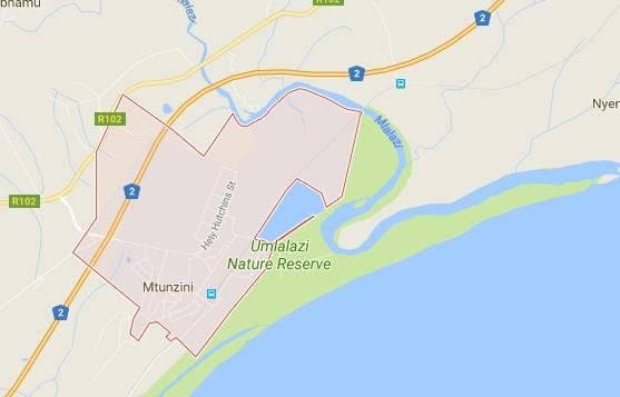
4.5. Town 5: Mtunzini
4.5.1. Introduction
Mtunzini is a small coastal town that is situated almost exactly halfway along KwaZulu-Natal's
coastline and it is found approximately 140 kilometres north of Durban. The next closest towns,
Empangeni or Richards Bay, are about 35-40 kilometres away to the north. The name of the town is
a Zulu word meaning “Place in the Shade” (Mtunzini.co.za, 2016). This name also is also derived from
the “place under the Milkwood Trees” which was found near the Umlalazi River. This is where the
22‘White Zulu’ chief, John Dunn, would meet with the tribal elders of the area. The town is located in
the Umlalazi Municipality, which forms part of the King Cetshwayo District Municipality (formerly
known as the uThungulu District Municipality). The town is found in the Zululand region of the
province (Mtunzini.co.za, 2016).
Figure 6: Map of Mtunzini
The climate in Mtunzini is such that it normally experiences hot and humid (sub-tropical) summers
with pleasant, mild winters. The town normally receives about 1067mm of rainfall per year, with
most occurring mainly during summer. It receives the lowest rainfall (35mm) in July and the highest
(136mm) in February. The average midday temperatures for Mtunzini range from 22.9°C in July to
28°C in January. The region is the coldest during July when the mercury drops to 11°C on average
during the night (SA Explorer, 2015).
The town has an estimated population of 2 199 (Stats SA, 2011), which most definitely classifies it as
a “small town” by definition. With the total area being 10.43km2, the population density of the town
is estimated to be ±210 people per km2. The breakdown in terms of population group is outlined in
Table 5 below:
Table 5: Population Groups for Mtunzini
Black 25.1%
White 72.0%
Indian 1.3%
Coloured 1.2%
Other 0.4%
Source: Census, 2011
4.5.2. History of the Town
During the late 1890s, the ‘Zulu Kingdom’ began to break up following the Anglo-Zulu War (ending in
1896). During this time, a colonialist, Sir Garnet Wolseley, went about creating 13 'kinglets' - with
two that were strategically located as ‘buffer zones’ between what known as Port Natal (Durban)
23and Zululand (Wikipedia, 2017). One of these kinglets was governed by John Dunn and he used
Mtunzini as his capital.
In 1948, a total area of 9 square kilometres (of dune forests, lakes and lagoon) at Mtunzini was
proclaimed as a nature reserve, which is known as the Umlalazi Nature Reserve (Mtunzini.co.za,
2016). This area falls under the protection and administration of Ezemvelo KZN Wildlife (previously
known as the Natal Parks Board).
In terms of more recent history, Mtunzini became a landing point for the South Africa Far East (SAFE)
submarine communications cable in 2002. This state of the art optical fibre cable was established as
a link between Melkbosstrand to the West, with Saint Paul (Réunion Island), Baie Jacotet (Mauritius),
Cochin (India) and Penang (Malaysia). In 2009, the town also became a landing point for the
SEACOM2 cable, and in 2010, it became the landing point for the EASSy3 cable (Wikipedia, 2017).
4.5.3 Profile of the Town
The town is a typical small coastal town with one main street stretching from the entrance to the
town, right through to the end of the town. A number of small streets branch off from this main
street and they lead to the various attractions and holiday homes which are found in the town. Apart
from the sugar cane plantations that surround the town, there is not much in terms of other
industries that operate in the town. It is very much a recreational town which thrives on the fishing
and other recreational activities in the town. This shows that the town has a massive potential to
become a small town whose economy is purely driven by tourism.
4.5.4 State of Tourism Readiness
Mtunzini is considered to be a bird-watchers’ paradise, and it is also one of the few places where
one of South Africa's rarest birds of prey, the palm-nut vulture, is found. These birds feed on the
fruit of the ‘Rafia Palm’ - which produces its fruit once every twenty years before dying
(Mtunzini.co.za, 2016). Visitors are given the opportunity to walk through the lush vegetation at the
Rafia Palm Monument, which features a raised boardwalk that meanders through to the magnificent
palm trees.
Mtunzini boasts, among other attractions, untouched beaches, a 9-hole golf course at the Mtunzini
Country Club, numerous bed-and-breakfast establishments as well as a range of camping,
caravanning, and other self-catering holiday accommodation establishments (Mtunzini.co.za, 2016).
The beach is not protected by shark nets, such as the ones in Durban, and this is due to Mtunzini's
proximity to a shark breeding ground which is populated by Zambezi sharks as well as many other
key species. The waves at Mtunzini are considered, by many surfers, as being some of the better
ones to surf on the North Coast of KZN (Wikipedia, 2017).
Further to this, the Umlalazi Lagoon is also a popular tourist attraction for water sports enthusiasts
and fishermen. Recreational and commercial ski-boat fishermen also launch their boats in the lagoon
to head out into the Indian Ocean via the mouth of the Umlalazi River (Wikipedia, 2017).
2
SEACOM is a submarine cable operator with a network of submarine and terrestrial high-speed fibre-optic
cable that serves the East and West coasts of Africa (Wikipedia, 2017).
3
EASSy is a 10,000km submarine fibre-optic cable system deployed along the east and south coast of Africa to
service the voice, data, video and internet needs of the region (EASSy, 2010).
245. Summary of Findings
It is well-known that KwaZulu-Natal has a lot to offer both foreign and domestic tourists, but there
are still a number of “hidden gems” across the province. As previously mentioned, many of these are
found in close proximity to small towns that are often considered to be “off the beaten track”. The
findings from this report are summarised below.
Town 1: Howick
1. Although the population is slightly more than that of a ‘small town’, the town was still
considered to be a part of this study due to its potential for tourism.
2. The town is well placed from the N3 highway (Durban to Johannesburg), and it is also forms part
of the N3 Gateway Tourism Association and the Midlands Meander.
3. In terms of road infrastructure, there is no need for major improvements. The signage, condition
of the roads, and traffic lights and road markings are all suitable at present.
4. The facilities on offer are also all up to a good standard. For example, there is good cell phone
reception, plenty of petrol stations available, and all major SA ATMs are available. There are also
very good health facilities available. There are a number of super markets in the town.
5. In terms of tourism amenities, there are a number of restaurants and accommodation
establishments that are available in the town and the surrounding areas.
6. There is a tourism information office available in the town, but improvements are needed in this
regard. One such issue that was discovered is that it was not open on a normal working day.
7. The town is a gateway, and host, to a number of sought-after tourist attractions – such as the
Mandela Capture Site, Karkloof Canopy Tours, and Midmar Dam and Nature Reserve. This has
increased its rating in terms of ‘readiness’.
8. Overall, the town was rated to be 70% ready for tourism with the general infrastructure and
attractions contributing greatly to this score. There are minor improvements needed for the
roads, and there are major improvements needed for the cleanliness of the town along with the
addition of foreign exchange services and Wi-Fi facilities.
Town 2: Nottingham Road
1. The town is easily accessible from the N3 highway that links Durban and Johannesburg. It is also
located on the N3 Gateway as well as the Midlands Meander.
2. The roads in and out of the town are in need of attention as there are a number of noticeable
and dangerous potholes. Apart from this, the signage leading to the town is sufficient and the
road markings are visible to all road users.
3. The facilities on offer are in need of minor improvements. For example, there is average cell
phone reception, only a one petrol station available (in the town), and there are few ATMs
available. There is no evidence of major health facilities that are available.
4. In terms of tourism amenities, there are a few restaurants and accommodation establishments
that are available in the town and the surrounding areas. There are no major improvements
needed here.
5. There is a tourism information office available in the town, but it is not well marketed or
prominent in the town.
25You can also read