Smedley Farmhouse (Former), OAKLEIGH (List No.1235, Category 2) - Heritage ...
←
→
Page content transcription
If your browser does not render page correctly, please read the page content below
New Zealand Heritage List/Rārangi Kōrero – Report for a Historic Place
Smedley Farmhouse (Former), OAKLEIGH (List No.1235, Category 2)

Smedley Farmhouse (Former), Oakleigh, looking east from garden.
(Alexandra Foster HNZPT, 12 February 2021)

Alexandra Foster
Last amended 11 June 2021
Heritage New Zealand Pouhere Taonga
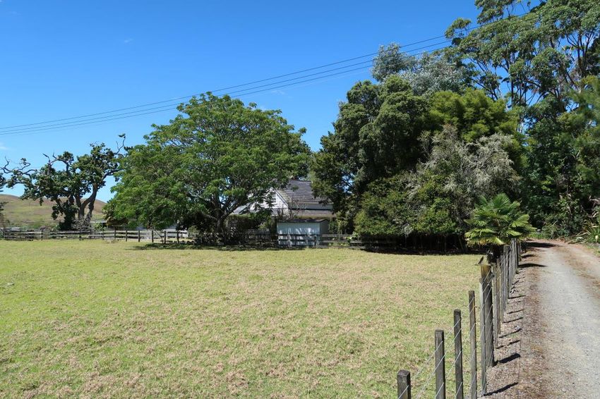
TABLE OF CONTENTS

EXECUTIVE SUMMARY                                                                                            3

1.       IDENTIFICATION                                                                                      4
1.1.     Name of Place                                                                                       4
1.2.     Location Information                                                                                4
1.3.     Legal Description                                                                                   5
1.4.     Extent of List Entry                                                                                5
1.5.     Eligibility                                                                                         5
1.6.     Existing Heritage Recognition                                                                       5

2.       SUPPORTING INFORMATION                                                                              6
2.1.     Historical Information                                                                              6
2.2.     Physical Information                                                                               14
2.3.     Chattels                                                                                           18
2.4.     Sources                                                                                            19

3.       SIGNIFICANCE ASSESSMENT                                                                            19
3.1.     Section 66 (1) Assessment                                                                          19
3.2.     Section 66 (3) Assessment                                                                          20

4.       APPENDICES                                                                                         22
4.1.     Appendix 1: Visual Identification Aids                                                             22
4.2.     Appendix 2: Visual Aids to Historical Information                                                  26
4.3.     Appendix 3: Visual Aids to Physical Information                                                    26
4.4.     Appendix 4: Significance Assessment Information                                                    30

Disclaimer

Please note that entry on the New Zealand Heritage List/Rārangi Kōrero identifies only the heritage values of
the property concerned, and should not be construed as advice on the state of the property, or as a comment of
its soundness or safety, including in regard to earthquake risk, safety in the event of fire, or insanitary
conditions.
Archaeological sites are protected by the Heritage New Zealand Pouhere Taonga Act 2014, regardless of
whether they are entered on the New Zealand Heritage List/Rārangi Kōrero or not. Archaeological sites include
‘places associated with pre-1900 human activity, where there may be evidence relating to the history of New
Zealand’. This List entry report should not be read as a statement on whether or not the archaeological
provisions of the Act apply to the property (s) concerned. Please contact your local Heritage New Zealand office
for archaeological advice.

              Heritage New Zealand Pouhere Taonga – List Entry Report for a Historic Place, List No. 1235          2
EXECUTIVE SUMMARY

Purpose of this report
The purpose of this report is to provide evidence to support the inclusion of Smedley Farmhouse
(Former) in the New Zealand Heritage List/Rārangi Kōrero as a Category 2 historic place.

Summary

Situated on the banks of the Mangapai River in the southern Whangārei Harbour, Smedley Farmhouse
(Former) lies within a contested landscape with connections to multiple iwi and has a long history of
Māori settlement. The extensive forests and waterways in the area were important resources for
Māori and included kauri which were considered a taonga. The place is an impressive late 1890s
timber residence linked with the transition from extractive to renewable industry in rural northland
communities. The place has historical significance as it reflects the dominant economic patterns in
North Auckland both through its links with the gum trade providing the capital for its construction and
quick expansion, and its later development as a farm under Frank Hilford who served as a local
councillor. The place remains largely intact and has the potential to provide information about locally
felled and processed kauri timber and construction techniques.

Multiple iwi including have connections to the landscape near the Mangapai River, including Te
Parawhau and Patuharakeke who settled the lands around Whangārei harbour. From 1854 notable Te
Parawhau rangatira Te Tirarau Kūkupa led eleven Parawhau rangatira in transferring a number of land
blocks around the harbour to the Crown. Te Mata block, including the site of Smedley Farmhouse
(Former), was acquired by the Crown in 1858. Early Pākehā settlements in the area were reliant on
extractive industries, particularly in kauri timber and gum which could be exported for national and
international markets via coastal shipping routes serviced by the mosquito fleet which operated in
northern New Zealand. Edwin Smedley dug – and possibly traded – gum near Dargaville prior to
acquiring over 80 acres of land near Oakleigh Wharf in late 1892.

After marrying Mary Hayward in 1894, Smedley built a one and a half storey wide gable cottage on his
property. Solidly constructed of kauri timber from a local sawmill, the residence had four rooms
downstairs with ladder access to additional rooms upstairs. Smedley continued to be involved in the
kauri gum trade and, with the close proximity of the wharf, established a gum store, boarding house
and store to cater to itinerant gum diggers in the area. The businesses were profitable and within a few
years Smedley expanded the residence into an impressive 10 room farmhouse with the addition of a
wide lean-to, wrap around verandah and balcony in circa 1900. Decorative features reminiscent of

             Heritage New Zealand Pouhere Taonga – List Entry Report for a Historic Place, List No. 1235   3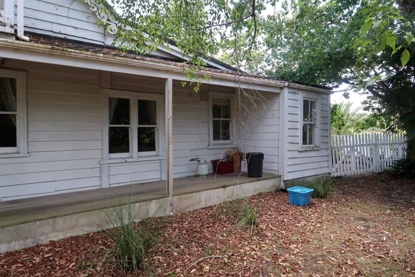
wealthy Whangārei villa style residences were added including rusticated weatherboards, timber
fretwork, chamfered verandah posts as well as curved rafters for a concave verandah roof. As well as
improving the house Smedley cleared his wider property, converting flax and fern scrub into pasture
for stock farming.

In 1901 Smedley sold the property to Hilford who fully transitioned the place to renewable industry as
a farm raising sheep and likely later cattle for export to Britain in a period which has been referred to
as recolonisation. Although the gum trading business ceased, the residence continued to have a public
function as a local post office which was established from the residence in 1912 and continued to
operate until 1945. As well as farming Hilford was involved in the rural community as a member of the
Mangapai Riding Farmers Association for many years and as a local councillor. Hilford also collected
export dues from users of the wharf. A later owner, Lucy Nutsford, regularly hosted the Women’s
Institute and other clubs at the residence. From the 1920s, developments in rail and road transport
reduced the importance of Oakleigh. Few changes were made to the place over the twentieth century
except some internal room rearrangements and two sections of the verandah were enclosed. In later
decades the farm was subdivided. The place remains a private residence.

1.           IDENTIFICATION1
1.1.         Name of Place

              Name
              Smedley Farmhouse (Former)

              Other Names
              Nutsford Cottage (1928 – present)
              Oakleigh

1.2.         Location Information

              Address
              1289 State Highway One and Oakleigh Wharf Road
              OAKLEIGH

1   This section is supplemented by visual aids in Appendix 1 of the report.

                  Heritage New Zealand Pouhere Taonga – List Entry Report for a Historic Place, List No. 1235   4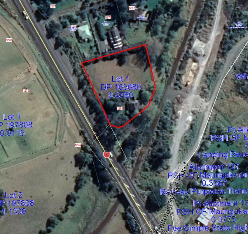
Additional Location Information
             NZTM Easting: 1718785.0
             NZTM Northing: 60339522

             Local Authority
             Whangārei District Council

1.3.         Legal Description

             Lot 1 DP 165680 (RT NA95C/655), North Auckland Land District.

1.4.         Extent of List Entry

             Extent includes the land described as Lot 1 DP 165680 (RT NA95C/655), North Auckland Land
             District, and the buildings and structures known as Smedley Farmhouse (Former) thereon.
             (Refer to map in Appendix 1 of the List entry report for further information).

1.5.         Eligibility

             There is sufficient information included in this report to identify this place. This place is
             physically eligible for consideration as a historic place. It consists of a combination of land,
             buildings, and structures that are fixed to land which lies within the territorial limits of New
             Zealand.

1.6.         Existing Heritage Recognition

             Local Authority and Regional Authority Plan Scheduling
             Not scheduled in Whangārei District Plan Operative 3 May 2007, (as amended).

             Not scheduled in Proposed Whangārei District Plan, Appeals Version, June 2020.

             New Zealand Archaeological Association Site Recording Scheme
             This place or sites within this place have been recorded by the New Zealand Archaeological
             Association. The reference is – Q07/1480 Smedley Farmhouse (Former)

2   Taken on approximate centre of the main residence.

                 Heritage New Zealand Pouhere Taonga – List Entry Report for a Historic Place, List No. 1235    5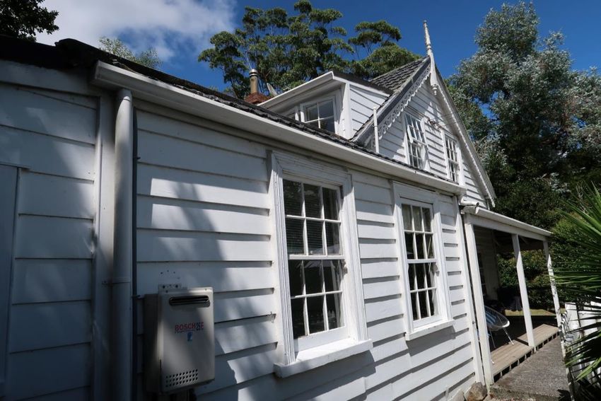
2.           SUPPORTING INFORMATION
2.1.         Historical Information

              Early history

              Smedley Farmhouse (Former) is located where the Mangapai River flows into the southern
              Whangārei Harbour. Lands in the south Whangārei area form part of a contested Māori
              landscape with connections to multiple iwi, including Te Parawhau and Patuharekeke. Sites of
              conflict in the wider harbour area include Otaika Creek, located several kilometres to the
              north, where an incoming Ngāti Maru taua overcame a Ngāpuhi force led by Tawhiro in the
              late 1700s and gave the area its name; and Mangawhati to the east within the rohe of
              Patuharakeke where multiple significant battles occurred.3 During the so called Musket Wars
              of the early nineteenth century, many inhabitants moved inland before returning to the coast
              from the late 1830s onwards.4 Kawanui, a Parawhau rangatira, established a papakāinga
              known as Matakitahe west of the Mangapai River in this period.5 Māori settlement in the
              immediate vicinity of the Smedley Farmhouse (Former) site is attested by several recorded
              archaeological sites including a pā, and features such as shell midden and storage pits.6

              Extensive native ngahere (forests) and interconnected waterways in the area were important
              resources for Māori including as sources of kai, timber and transport routes. Kauri, which
              grew exclusively in the northern North Island, were considered taonga and featured in
              whakataukī and pakiwaitara (traditional stories).7 The timber was used for waka while kāpia
              (kauri gum) had multiple uses including for medicinal purposes, as fire starter and for

3   The area is also known as Skull Creek. Patuharakeke Te Iwi Trust Board, ‘Submission re: Proposed Regional Plan’, Appendix
      A (68), 15 Nov 2017; Patuharakeke Te Iwi Trust Board, ‘Site, area or landscape of significance to tangata whenua
      worksheet- Mangawhati Mahinga Mataitai’, nrc.govt.nz, n.d., URL:
      https://www.nrc.govt.nz/media/imua4ezc/patuharakeke-mangawhati-mahinga-mataitai2.pdf; Whangārei District
      Council, ‘Otaika, Raumanga and Toe Toe: Structure Plan’, Whangārei, Feb 2009, p. 8, URL:
      https://www.wdc.govt.nz/files/assets/public/documents/council/plans/urban-structure-plans/otaika-raumanga-toe-toe-
      structure-plan-2009.pdf; Florence Keene, Tai Tokerau, Whangārei, 1986, pp. 39-40.
4   Nancy Preece Pickmere, Whangarei: The Founding Years, Whangārei, 1986, p. 14.
5   ibid., p. 63; Site Records: Q07/532, Q07/533, Q07/534, New Zealand Archaeological Association, URL:
       https://archsite.eaglegis.co.nz/NZAA
6   Site Records: Q07/485, Q07/506 Q07/531, Q07/886, Q07/1292, Q07/1293, New Zealand Archaeological Association, URL:
       https://archsite.eaglegis.co.nz/NZAA
7   Pakiwaitara related to kauri include northern Māori retellings of the separation of Ranginui and Papatūānuku in which
      Tane’s legs were kauri trunks, and that Kauri and Tohora (whales) are brothers. Joanna Orwin, Kauri: Witness to a
      Nation’s History, Auckland, 2004, p. 20-21; ‘Significance of Kauri to Māori Culture’, in ‘Keep Kauri Standing’, URL:
      https://www.kauriprotection.co.nz/significance-of-kauri/ [accessed 9 April 2021]; Joanna Orwin, 'Kauri forest - Using
      kauri', Te Ara - the Encyclopedia of New Zealand, 24 Sep 2007, URL: http://www.TeAra.govt.nz/en/kauri-forest/page-3
      [accessed 9 April 2021]; ‘Kauri (Agathis australis)’, Museum of New Zealand Te Papa Tongarewa, URL:
      https://collections.tepapa.govt.nz/topic/1016 [accessed 9 April 2021].

                  Heritage New Zealand Pouhere Taonga – List Entry Report for a Historic Place, List No. 1235                   6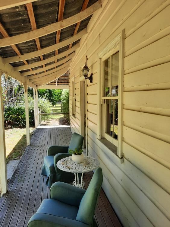
torches. The burnt soot from kāpia was also used for tā moko.8 By the early nineteenth
              century kauri spars were among the resources traded with early settlers for European goods.9

              The Crown first obtained land around the Whangārei Harbour in 1854 when Te Tirarau
              Kūkupa, a notable Te Parawhau rangatira, led a group of eleven Parawhau rangatira in
              agreeing to transfer the Maungatapere Block.10 Te Tirarau Kūkupa resided at Tangiterōria on
              the Northern Wairoa River and ‘held authority over the area south and west of Whangārei
              Harbour, and by conquest his power extended to Kaipara Harbour’.11 The Crown
              subsequently acquired more land in the area including Te Mata Block in 1858, upon part of
              which Smedley Farmhouse would later be built.12 In ensuing years the government laid out
              small European settlements in the area including Maungakaramea and Mangapai, both
              beside tributaries of the Mangapai River, west of the harbour.

              The colonial economy of Auckland Province, and Northland in particular, was heavily reliant
              on extractive industries such as kauri timber and gum.13 Kauri felling and export formed a
              major industry from early European arrival and the gum, dug from the ground, similarly
              formed a popular international commodity, converted into furniture polish and other
              products.14 Under the new colonial system the existing Māori economy was effectively
              dismantled as the impacts of land loss by raupatu and through the Native Land Court and
              Waste Lands Act, agricultural farming difficulties and stagnation, and increased numbers of
              Pākehā traders and coastal shippers challenged Māori dominance.15 Consequently many

8   ibid.
9   Orwin, 2007.
10   The Crown paid Te Tirarau Kūkupa £1500 for the Mangatapere Block in January 1855. H. Hanson Turton, Māori Deeds of
      Land Purchases in the North Island of New Zealand: Volume One, Wellington, 1877, p. 140, URL:
      http://nzetc.victoria.ac.nz/tm/scholarly/tei-Tur01Nort-t1-g1-g1-g1-g4-t10.html#n169 Steven Oliver. 'Te Tirarau Kūkupa',
      Dictionary of New Zealand Biography, first published in 1993. Te Ara - the Encyclopedia of New Zealand,
      https://teara.govt.nz/en/biographies/2t31/te-tirarau-kukupa (accessed 12 March 2021); Preece Pickmere, 1986, p. 63.
11   Te Tirarau Kūkupa also had links through descent and marriage to Ngāpuhi, Ngāti Ruangaio, Te Uri-o-Hau, Ngāi Tāhuhu,
      and Te Uriroroi. Over his life he was involved in several conflicts with other iwi and was an ally of Hongi Hika from the
      1820s. In 1834 a Wesleyan mission was established under his protection at Tangiterōria. Te Tirarau Kūkupa also signed
      both Whakaputanga o te Rangatiratanga o Niu Tīreni Declaration of the Independence of New Zealand and Tiriti o
      Waitangi Treaty of Waitangi. Oliver, 1993.
12   Turton, 1877, p. 151, URL: http://nzetc.victoria.ac.nz/tm/scholarly/tei-Tur01Nort-t1-g1-g1-g1-g4-t20-g1-t2.html
13   R.C.J. Stone, Makers of Fortune: A Colonial Business Community And Its Fall, Auckland, 1973, p. 32
14   Stone, 1973, p. 93; Nancy Swarbrick, 'Logging native forests - The timber industry, 1840–1920', Te Ara - the Encyclopedia of
       New Zealand, 24 Sep 2007, URL: http://www.TeAra.govt.nz/en/logging-native-forests/page-3 (accessed 20 March 2021);
       Janet Riddle, Saltspray and Sawdust: One Thousand Years of History in Mercury Bay, Te Whanganui-A-Hei, Coroglen,
       1996, p. 97.
15   Hazel Petrie, Chiefs of Industry: Maori Tribal Enterprise in Early Colonial New Zealand, Auckland, 2006, pp. 227-30, 253-5;
      Orwin, 2004, p. 135; Adrienne Puckey, Trading Cultures: A History of the Far North, Wellington, 2011, p. 91.

                   Heritage New Zealand Pouhere Taonga – List Entry Report for a Historic Place, List No. 1235                      7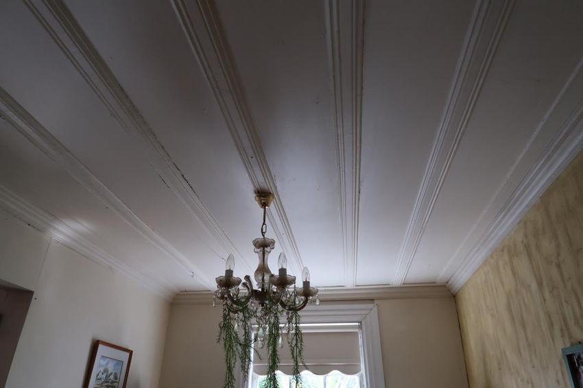
Māori were forced to seek new ways to survive and embrace new opportunities including
                employment in the extractive industries which still had the potential to be lucrative and
                profitable.16 Māori were the earliest gum diggers and last to leave as gum was located in
                their ancestral lands.17 It has been said that ‘[the Māori] economy had been knocked back
                and knocked back. Their cupboards — the forest, the moana — were being emptied. They
                came to the point of saying: ‘Well, the only economy we have is to cut down the trees and
                sell them to the Pakeha’.18

                Export of kauri resources for the national and international market was assisted by a network
                of wharves along the coast, including the Whangārei Harbour, which serviced a ‘mosquito’
                fleet of small boats including timber scows centred on the major entrepôt and port at
                Auckland - this pattern of intensive, small-vessel transport differed from waterborne trade
                elsewhere in New Zealand.19 By 1876, a wharf at the tidal mouth of the Mangapai River had
                been erected - generally known as Maungakaramea Wharf - and an associated landing
                reserve gazetted in 1881.20 In 1891, Coulthard Brothers built a timber mill close to the wharf,
                processing pockets of remaining kauri in the surrounding hills, which was otherwise being
                burnt off as widespread natural resource extraction began to give way to more permanent
                settlement activity such as farming.21

                When the mill opened, a journalist reported that ‘no doubt many who did with any sort of
                house previously will now be induced to make themselves more comfortable by getting
                better houses, now that timber can be had without the cost of freight from Auckland’.22
                Within a few years, a substantial residence would be built just a few hundred metres away,
                close to the wharf and landing reserve, almost certainly using timber from the mill - the
                Smedley Farmhouse.

16   Kennedy Warne, ‘Heke Tangata: The ebbing tide’, in E-Tangata, 20 May 2018, URL: https://e-tangata.co.nz/history/heke-
      tangata-the-ebbing-tide/ [accessed 9 April 2021]
17   Puckey, 2011, p. 88.
18   Warne, 2018.
19   The mosquito fleet provided the main connection for small rural settlements in ‘roadless’ North Auckland to larger urban
      centres, mixing transport of goods, people and mail, prior to the extension of road and rail in the twentieth century.
      Gavin McLean, Captain’s Log: New Zealand’s Maritime History, Auckland, 2001, pp. 79, 115-116; Gavin McLean, ‘Hobson
      to Hubbing: Change and Continuity in Auckland’s Maritime History’, in Ian Hunter and Diana Morrow (eds.), City of
      Enterprise: perspectives on Auckland Business History, Auckland, 2006, p. 56.
20   New Zealand Gazette, 1881, p. 1221; New Zealand Herald (NZH), 2 Feb 1876, p. 3.
21   NZH, 12 Feb 1891, p. 6, 24 Jun 1891, p.6.
     22   NZH, 24 Jun 1891, p.6.

                    Heritage New Zealand Pouhere Taonga – List Entry Report for a Historic Place, List No. 1235                 8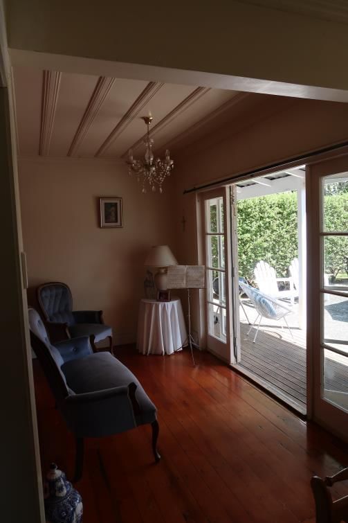
Creation and early use of Smedley Farmhouse (1894-1901)

              Construction and early use of the Smedley Farmhouse was directly linked with the latter
              period of the extensive kauri gum extraction industry in the area, and the rise of North
              Auckland’s subsequent economic priority, farming.

              In October 1892 the Government surveyed and opened more of the Maungakaramea parish
              for settlement and auctioned a small number of low acreage sections beside
              Maungakaramea Wharf.23 Edwin James Smedley, an engineer’s son originally from Belper,
              Derbyshire, purchased a nearly two acre section at the auction and subsequently leased
              Section 142, with a right to purchase, expanding his landholding by a further 81 acres which
              adjoined his lot and the Landing Reserve.24 This property was largely covered by fern scrub
              and flax with a high hill in the west part while being fairly flat on the east side nearest the
              Mangapai River.25

              Smedley had immigrated to New Zealand with his parents, brother, sister, and brother-in-law
              in 1889.26 The family had settled at Maungakaramea to farm while Edwin, perhaps reflecting
              his later entrepreneurial streak, struck out westwards to dig – and perhaps trade – kauri gum
              near Dargaville prior to purchasing his property near the wharf.27 In 1894 Smedley married
              Mary Amelia Hayward, also from Maungakaramea whose family had been among the first
              Pākehā settlers to the area in the 1870s.28

              While Smedley may have temporarily continued gum digging in the Dargaville area
              immediately after acquiring his property it is likely he moved permanently to the holding in
              1894 after getting married. Smedley appears to have built a simple initial one and half storey
              residence in the south eastern part of the leased land with assistance from Mary’s brother
              Charlie Hayward, and their brothers-in-law, Frank Christopher Hilford and Harry Hilford, who

23   Auckland Star (AS), 21 Oct 1892, p. 3; NZH, 22 Oct 1892, p. 5.
24   AS, 21 Oct 1892, p. 3; NZH, 22 Oct 1892, p. 5; RTs NA66/32, NA72/132, LINZ; England Census, 1881, Derbyshire, Belper, ALL
      District 5, p. 13 (accessed via Ancestry.com, 11 Mar 2021).
25   SO 1078, LINZ. This larger lot had earlier been identified as a site for a potential township by the Crown but was never
      developed
26   NZH, 12 Aug 1889, p. 12.
27   RT NA72/198, LINZ; New Zealand Electoral Roll: Northland Marsden, 1893, pp. 26, 59, Northland Bay of Islands, 1893, p.59;
      Wise’s New Zealand Post Office Directory: 1892-3, p. 1135, 1894-5, p. 105.
28   Births Deaths and Marriages, Marriage Registration No. 1894/167, URL:
       https://www.bdmhistoricalrecords.dia.govt.nz/home , Bethany O’Shea, Maungakaramea: Past and Present,
       Maungakaramea, 1985, p. 63.

                  Heritage New Zealand Pouhere Taonga – List Entry Report for a Historic Place, List No. 1235                    9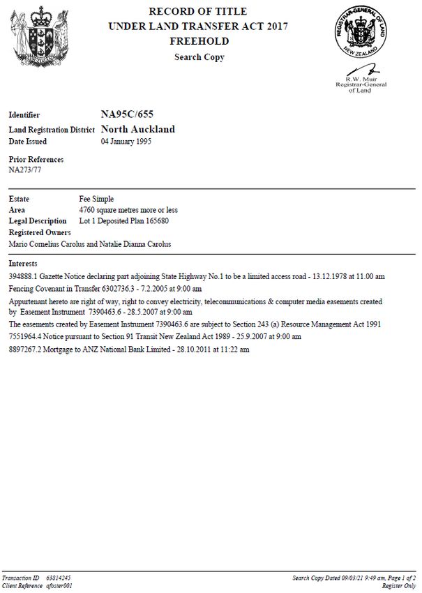
were married to Mary’s sisters.29 The building was a wide gable cottage with four rooms
              downstairs and further rooms on the upper floor accessed by a central ladder. The residence
              was constructed from local kauri timber, likely from the Coulthard Mill, and had twelve pane
              windows, a corrugated iron roof and was oriented to look westwards over the main part of
              the property and towards Maungakaramea.

              The building combined use as a family home with commercial functions and its role as the
              centrepiece of a burgeoning farm. Smedley appears to have steadily worked to clear and
              convert the fern covered land into farmland. By 1900, the property was described as being
              good land with 45 acres of ‘splendid black soil’ and several paddocks which were ‘ploughed
              and in grass’.30 Assisted by the close proximity of the wharf, however, the main focus of his
              activities remained connected with the gum trade. By 1898 Smedley was operating a gum
              business, store and boarding house from his residence capitalising on the improving
              economic situation as the country emerged from the Long Depression, and the last burst of
              activity in the extractive timber and gum digging industries in the North before the resources
              were exhausted.31 Smedley provided food, goods and accommodation to itinerant workers
              and purchased gum for export to Auckland and onto the international market. Smedley also
              actively recruited gum diggers for private fields as an agent acting for other local settlers.32 By
              1900 Smedley had an annual turnover of £1500-£2000 from his businesses.33

              Store accommodation was common through Northland and was a downmarket option in
              contrast to farmhouse accommodation or hotels.34 In 1899, only a few years after original
              construction, Smedley took out a mortgage on the leased property and appears to have
              invested in improvements to the residence which as well as improving the quality of
              accommodation on offer, created a more impressive farmhouse commensurate with the
              improved property.35

              The improvements were reminiscent of the houses of wealthy landowners in nearby
              settlements, such as Clarke Homestead in Maunu, a large villa style residence built for Dr

29   O’Shea, 1985, p. 212 Florence Keane, p. 81.
30   NZH, 11 Jul 1900, p. 8.
31   NZH, 11 Jul 1900, p. 8; Swarbrick, 24 Sep 2007.
32   AS, 17 Jun 1899, p. 1; Northern Advocate (NA), 13 Sep 1902, p. 2.
33   NZH, 11 Jul 1900, p. 8.
34   NZH, 21 Apr 1894, p. 1 (supplement).
35   RT NA72/298, LINZ

                   Heritage New Zealand Pouhere Taonga – List Entry Report for a Historic Place, List No. 1235      10
Alexander Clark in circa 1885, and projected the affluence the Smedleys aspired to.36 The
residence was expanded with a lean-to on the back facing the wharf, while a wraparound
verandah and balcony were added to the sides of the building which looked over the bulk of
the farm and were visible from the road to Maungakaramea. Decorative elements were
added to the house including timber fretwork and chamfered verandah posts, curved
verandah and balcony rafters, a section of rusticated weatherboards on the west elevation
around the front door, four-pane sash windows, and French doors.37 The internal layout was
also changed with the addition of a staircase to the upstairs rooms and access to the new
verandah from three rooms via French doors. The residence was described as nearly new
with ten rooms and had a separate bathroom in an outbuilding.38
In July 1900 Smedley advertised the residence and wider property for sale and it was
purchased in 1901 by Frank Hilford, one of the original builders of the house, who later
acquired the freehold in 1910.39 With its sale, its use as a store and boarding house ceased.
Ongoing use as a farmhouse (1901-1975)
Smedley Farmhouse (Former) remained the primary residence for a small farm for most of
the twentieth century. The residence generally retained its overall form and appearance
throughout this period and subsequently.
As extractive industries exhausted their potential, including the increased scarcity of kauri by
1905, settlers shifted to renewable industry including farming.40 During a period of tightening
connections between New Zealand and Britain identified by historian James Belich as
recolonisation, the number of small farms around New Zealand increased 30-fold between
1890 and 1911, largely on the back of protein farming of sheep, cattle and dairy for
refrigerated export to Britain.41 Hilford and his wider family were established sheep and dairy
farmers at Waikiekie and initially Hilford moved his existing sheep stock to his new farm.42
36 Clarke Homestead, also known as Glorat, is a Category 2 historic place, List No. 478. New Zealand Heritage List/Rārangi
Kōrero, URL: https://www.heritage.org.nz/the-list/details/478; Kiwi North, ‘Historic Buildings’, URL:
https://www.kiwinorth.co.nz/historic-buildings (accessed 20 Mar 2021); Florence Keene, Legacies in Kauri: Old Homes &
Churches of the North, Whangārei, 1978, p. 70.
37 These elements are visually similar to Clarke Homestead.
38 NZH, 11 Jul 1900, p. 8.
39 ibid., RT NA72/298, LINZ
40 James Belich, Paradise Reforged: From the 1880s to the Year 2000, Auckland, 2001, p. 18
41 Belich, 2001, pp. 29-30
42 AJHR, ‘The Annual Sheep Returns for the Year Ended 30 April, 1901’, Wellington, 1901, p. 16; AJHR, ‘The Annual Sheep
Returns for the Year Ended 30 April, 1902’, Wellington, 1902, p. 16; J.T. Stephen, Early Northland: Waikiekie Pioneers
Heritage New Zealand Pouhere Taonga – List Entry Report for a Historic Place, List No. 1235 11Hilford stopped sheep farming by April 1905 and, with the construction of cattle yards at
Maungakaramea Wharf in circa 1904, likely shifted to cattle farming like other local
farmers.43 Regular export of produce for the national and international market continued to
be vital for the success of rural communities and the mosquito fleet continued to regularly
visit Maungakaramea wharf. By the early twentieth century the Northern Steamship
Company ran two services per week to the wharf and in 1906 Hilford was appointed to
collect export dues from other local farmers. The subsequent owner of the farm, John Crane
temporarily held the role until Hilford’s successor could be appointed.44 The Hilfords also
established an orchard in the paddock immediately north of the residence growing fruit
including pears, nectarines and quinces.45
In February 1912 a post office, initially known as Mangapai Wharf Post Office, was opened
and run from one of the back rooms in the lean-to.46 In this fashion the residence continued
to have a public role in the rural community despite primarily being a farm. Early mail
deliveries to the area were by boat, although mail was likely brought by rail and road later in
the century.47 In 1913 the name Oakleigh came to be associated with the community and the
post office and wharf were officially renamed in 1913 and 1916 respectively.48 Oakleigh Post
Office continued to be run from the residence by successive owners until its closure in
1945.49
For a short period of time from the mid-1910s Smedley Farmhouse (Former) was located
immediately beside the the terminus of the North Auckland Railway which extended the
continuous railway from Auckland to Oakleigh by 1916.50 A portion of the farm along the
southern and eastern boundary was taken for the railway and Oakleigh station was built
between the farmhouse and the wharf. The wharf remained an important shipping
1860-1900 and their Descendants, Whangārei, 1983, pp. 102-3, 118-9.
43 NA, 21 Dec 1906, p. 3, 6 Aug 1910, p. 5; AJHR, ‘The Annual Sheep Returns for the Year Ended 30 April, 1905’, Wellington,
1905, p. 17;
44 NA, 18 Jun 1917, p. 1.
45 NA, 30 Jan 1913, p. 3.
46 R.M. Startup, New Zealand Post Offices, Hastings, 1977, p. 95
47 NA, 14 Oct 1921, p. 6; McLean HH, 2006, p. 56.
48 NA, 1 May 1916, p. 1; NZH, 4 May 1916, p. 3; RM Startup, 1977, p. 124.
49 Keene, 1978, p. 81; ‘The Maungakaramea and Mangapai Wharves’, in ‘UF018 Scrapbook’, Whangārei Recollect, Whangārei
District Library, URL:
https://whangarei.recollect.co.nz/nodes/view/2087?highlights=WyJvYWtsZWlnaCkiLCJvYWt0ZWlnaCwiLCJvYWsxZWlnaC
4iLCJvYWtsZWlnaCJd&keywords=Oakleigh#idx24153
50 SO 18721, LINZ; NA, 29 Jan 1915, p. 4; ‘Florence Keene Scrapbook 5’, Whangārei Recollect, Whangārei District Library, URL:
https://whangarei.recollect.co.nz/nodes/view/1296.
Heritage New Zealand Pouhere Taonga – List Entry Report for a Historic Place, List No. 1235 12connection to Whangārei and farther north until the early 1920s when a further extension
fully connected the line directly to Whangārei by rail thus diminishing the importance of
Oakleigh within the North Auckland transport network.51 Hilford unsuccessfully attempted to
take advantage of the proximity of the terminus and had a number of residential lots
surveyed and subdivided in 1916 in the north eastern part of the farm.52 After selling
Smedley Farmhouse (Former) with the western portion of the farm in 1917, Hilford retained
the subdivision until 1922 when, with the railway extension completed, he sold them as a
block that was later largely reintegrated into the rest of farm from 1928.53
Membership of farming and rural organisations was an important way in which farming
communities remained connected. Hilford was an active member of the Mangapai Riding
Farmers Association for many years and was elected onto the committee multiple times
between 1906, and 1914 while he farmed the property.54 Between 1908 and 1911 Hilford
also served as a councillor on the Whangarei County Council.55 From 1928 to 1949 the farm
was owned by Lucy Nutsford with her husband George Frederick Ernest Nutsford, a farmer
and former motor garage and taxi proprietor, who had previously lived in Whangārei.56 Lucy
Nutsford developed a praised flower garden around the residence which became known as
Nutsford Cottage.57 She was involved in women’s organisations including the Women’s
Institute and the Whangarei Ladies’ Gardening Club and often hosted both groups in the
residence and garden.58 The Nutsfords were relatively well-to-do and hosted parties for
friends who motored to Oakleigh from Whangārei, and Nutsford also on occasion drove to
Auckland.59
As the roading network north of Auckland improved over the twentieth century Smedley
Farmhouse (Former) continued to be at the nexus of transport routes as the main road north
51 NA, 15 Apr 1921, p. 3, 10 Feb 1922, p. 6, 20 Mar 1924, p. 6.
52 DP 11683, LINZ; NA, 24 Nov 1916, p. 3.
53 RTs NA176/62, NA275/172, NA275/173, NA363/240, LINZ
54 The association operated between 1895 and 1920. NA, 13 Jul 1906, p. 4, 23 May 1910, p. 3, 3 Sep 1910, p. 5, 31 May 1912,
p. 5, 30 Jan 1913, p. 3, 9 Jun 1914, p. 2; NZH, 19 Nov 1895, p. 6.
55 Stephen, 1983, p. 102.
56 RT NA 273/77, LINZ; NA, 27 Sep 1918, p. 3.
57 Keene, 1978, p. 81
58 Nutsford was notably a judge of flower, decorative, and cooking sections at farm shows and regularly travelled around the
region to shows including at Hukerenui, Matakana, North Kaipara, and Whangārei. NA, 14 Feb 1929, p. 6, 16 May 1929, p.
6, 14 Mar 1932, p. 3, 27 Apr 1935, p. 4, 28 Feb 1936, p. 4, 18 Apr 1936, p. 9, 3 Nov 1938, p. 2,10 Feb 1941, p. 2, 20 Mar
1948, p. 3; NZH, 21 Feb 1933, p. 3, 5 Dec 1933, p. 3, 18 Mar 1934, p. 43 Nov 1938, p. 9; Rodney and Otamatea Times,
Waitemata and Kaipara Gazette, 6 Feb 1935, p. 4, 20 Feb 1935, p. 5.
59 NA, 16 Sep 1933, p.5, 19 Nov 1938, p. 2; NZH, 25 Oct 1937, p. 3.
Heritage New Zealand Pouhere Taonga – List Entry Report for a Historic Place, List No. 1235 13passed to the west of the place. The intersection of the road and railway, immediately beside
the driveway south west of the residence, was a dangerous section of road and the key for a
roadside first aid kit was kept at the farmhouse in case of accidents.60 In 1938 the road was
raised on a bridge over the railway. The road has been realigned over subsequent decades
including extending the road surface at the height of the bridge past the residence which cut
off the view of the western half of the farm from the residence in the early twenty-first
century.
Later changes to Smedley Farmhouse (Former)
From 1928 Smedley’s farm mostly remained in the same ownership as a working farm. In
1968 and 1979 much of the property was sold although the orchard and residence remained
as a single property.61 By 1942 a driveway had been formed along the southern boundary
which later became a limited access road from the State Highway.62 After the road was
subsequently raised the driveway was extended around the west boundary.63 With the
changes to the grounds the main entrance to the house changed to the lean-to. The
residence has had minor alterations to its internal configuration with changes limited to
creating internal bathrooms, combining rooms into a larger room, and enclosing two sections
of the back verandah.64 The residence was reblocked in the 1970s and re-piled since 2005
along with some additional repairs.65 In 2021 the place remains a private residence.
Associated List Entries
N/A
2.2. Physical Information
Current Description
Context
Smedley Farmhouse (Former) is located at Oakleigh, south of Whangārei, on a flat plain by
the northern branch of the Mangapai River. The area is predominantly rural with a number of
60 Keene, 1978, p. 82.
61 RTs NA273/77, NA275/172, NA31C/925, LINZ
62 Refer Figure 1. Historic aerial imagery showing Smedley Farmhouse (Former) in 1942. Note railway to right of residence
and road to the left.
63 Google Earth Pro, Historic Aerial Imagery, 8 Jul 2003, 24 Mar 2012.
64 Keene, 1978, p. 81.
65 ibid.; pers comm., Mario Carolus to Alexandra Foster, 12 Feb 2021.
Heritage New Zealand Pouhere Taonga – List Entry Report for a Historic Place, List No. 1235 14late twentieth and early twenty-first century residences in the surrounding landscape,
including two residences constructed after 2004 immediately north of the place. A circa 1900
residence associated with an 1891 sawmill is located to the southwest of Smedley Farmhouse
(Former).
The place lies between the junction of multiple transport networks. The place is bounded by
State Highway One on the west side and the North Auckland Railway Line runs past the
southern and eastern boundary. A limited access road which comprises the former driveway
is located by the south west corner. Immediately east of the railway line is the former railway
station, clear of buildings with an unpaved gravel section, and the nineteenth century landing
reserve with a twentieth century wharf.
Site
The Smedley Farmhouse (Former) site is generally rectangular, tapered at the south end. The
site is comprised of a two-phase residence in the southern half, a grassed paddock, a former
early twentieth century orchard with sheep in the northern half, and a driveway which runs
along the western boundary around the south and east of the residence with an inner picket
fence.66 A two-car garage with weatherboard cladding and a corrugated iron roof is located at
the end of the driveway with a water tank behind. The west boundary includes a stone
retaining wall associated with the raising of the road.
Landscaping around the residence includes a raised garden within a picket fence in front of
the residence separated by a path from a second garden. A paved area on the north side of
the residence, with a hedge screening the paddock, is externally accessible via a path formed
of railway sleepers. The remainder of the site immediately surrounding the residence is in
grass with a number of mature trees including oak trees, a cabbage tree and a jacaranda. The
paddock is lined by trees on the north and east sides.
Residence
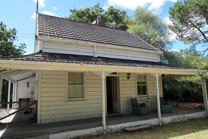
The good quality, solidly built kauri timber residence was created in two early phases - an
1894 cottage and a circa 1900 extension with decorative villa elements – with minor
subsequent alterations. The residence remains largely intact with its slight L-shaped plan and
layout generally maintained with minor alterations to combine rooms to form a larger space.
66 See Figure 2.
Heritage New Zealand Pouhere Taonga – List Entry Report for a Historic Place, List No. 1235 15A number of early features have been retained since the residence was created by its first
owner.
- Exterior
The structure consists of an initial one and a half storey wide gable cottage with a lean-to on
its east side. The structure also features a wraparound verandah on the north, west and
south elevations and a small balcony in the southern gable.67 The main roof gable is
orientated north to south over the 1894 building and extends at the lower pitch over the
lean-to. The verandah roof has a slight concave shape with curved rafters. A concrete slab
verandah deck has been covered with a timber deck. Two sections of verandah on the east
elevation are enclosed with an extended verandah roof between. The residence is generally
clad with plain weatherboards and all the roofs are tiled with decramastic tiles. At the join of
the original structure and the lean-to on the south side is a visible break in the
weatherboards which shows the connection of the separate elements.68
The original front elevation retains many of the villa decorative features which were added in
1900.69 These include rusticated weatherboards, timber fretwork brackets around the
verandah posts, and a central four-panel glazed door, with a later rectangular fan-light above.
Further fretwork brackets have survived on the south elevation at both verandah and balcony
level and the later also retains its original chamfered posts and railing. Each gable has
fretwork bargeboards and a tall finial is present on the north gable.
Most of the windows are four pane sash windows with moulded architraves excepting the
north elevation which retains earlier four twelve pane windows – two sash windows in the
lean-to and two hinged in north gable70 – and the south elevation which has a pair of two
pane sash windows with a prominent sill that evidently are a later twentieth century
replacement of a doorway. A modern dormer window has been added in the east side of the
roof. A pair of French doors with moulded details are located in the balcony and two further
sets of French doors with plain architraves are present on the north side, opening onto the
wraparound verandah. The original twelve pane rear entrance door has been relocated to
the southern enclosed verandah room and a twenty-first century front door added.
67 See Figure 3.
68 See Figure 4.
69 See Figure 6.
70 See Figure 5.
Heritage New Zealand Pouhere Taonga – List Entry Report for a Historic Place, List No. 1235 16- Interior
The ground floor contains a kitchen and bathroom in the lean-to, an expanded dining room, a
sitting room, and two bedrooms at the rear, and a laundry in the enclosed section of
verandah. The dining room and bedrooms maintain external access onto the verandah and
paved patio. A back-to-back fireplace is located on the shared wall between the sitting room
and south bedroom. The bedroom fireplace has a cast iron grate and surround and
decorative timber mantle which likely dates from the late nineteenth century. A modern
woodburner with simple plaster surround is installed in the sitting room.
The floors are mainly tongue and groove kauri timber and the door architraves and skirting
boards are moulded. The ceilings are board and batten except in the renovated bathroom
and are generally orientated east to west in the 1894 structure and north to south in the
lean-to.71
The staircase, likely added during the circa 1900 alterations, is centrally located entirely
within the 1894 structure facing the main entrance from the lean-to. The staircase has
acoustic lining and ceiling tiles.
Upstairs the rooms are arranged around a central north-south passage with the largest
bedroom in the southwest corner. The room, through which the balcony is accessed, has a
board and batten ceiling which extends into the passage while the other rooms have
plastered ceilings. The rooms have sloped ceilings to collar height with exposed kauri beams
except the northeast bathroom which has a dormer window on the east side with a view
overlooking the landing reserve towards Mangapai River. A trapdoor covering the original
ladder opening is located in the south east room. Large kauri rafters are visible in the roof
space and a layer of earlier corrugated iron roofing is present beneath the external roof tiles.
Construction Professionals
Edwin James Smedley (Builder – 1894)
Charlie Haywood (Builder – 1894)
Frank Christopher Hilford (Builder – 1894)
Harry Hilford (Builder – 1894)
71 See Figure 7 and Figure 8.
Heritage New Zealand Pouhere Taonga – List Entry Report for a Historic Place, List No. 1235 17Construction Materials
Kauri Timber
Tile
Brick
Corrugated iron
Key Physical Dates
circa 1894 Original Construction - Residence
circa 1900 Addition – Lean-to, verandah, and balcony, staircase; Removal - ladder
1917-1978 Modification – Downstairs bedroom converted into bathroom; fireplaces
replaced; internal walls removed
1973-1978 Modification – enclosure of two sections of verandah; reblocking
Pre-2005 Modification – upstairs bedroom converted into bathroom and dormer
window added; staircase relined
Post 2005 Residence re-piled; bathroom renovated and north verandah access moved to
internal access
Uses
Accommodation Boarding/Guest House (Former)
Accommodation Garden – private
Accommodation House
Agriculture Farm (Former)
Agriculture Orchard (Former)
Agriculture Paddock
Communication Post Office (Former)
Trade Trading Station (Former)
2.3. Chattels
There are no chattels included in this List entry.
Heritage New Zealand Pouhere Taonga – List Entry Report for a Historic Place, List No. 1235 182.4. Sources
Sources Available and Accessed
Primary sources used included Land Information New Zealand Records of Title and surveys
plans, and newspaper articles from the National Library accessed via Paperspast.
Secondary sources include detailed local histories of Whangārei and the surrounding area, Te
Ara Encyclopedia of New Zealand, and historical records held in the Whangārei District
Library digital collections.
A site visit was undertaken in February 2021 and the site was fully accessed.
Further Reading
Keene, Florence, Legacies in Kauri: Old Homes & Churches of the North, Whangarei, 1978,
O’Shea, Bethany, Maungakaramea: Past and Present, Maungakaramea, 1985, pp. 63, 212.
Stephen, J.T., Early Northland: Waikiekie Pioneers 1860-1900 and their Descendants,
Whangārei, 1983, pp. 102-3.
‘The Maungakaramea and Mangapai Wharves’, in ‘UF018 Scrapbook’, Whangārei Recollect,
Whangārei District Library, URL:
https://whangarei.recollect.co.nz/nodes/view/2087?highlights=WyJvYWtsZWlnaCkiLCJvYWt0
ZWlnaCwiLCJvYWsxZWlnaC4iLCJvYWtsZWlnaCJd&keywords=Oakleigh#idx24153
3. SIGNIFICANCE ASSESSMENT72
3.1. Section 66 (1) Assessment
This place has been assessed for, and found to possess archaeological and historical
significance or value. It is considered that this place qualifies as part of New Zealand’s historic
and cultural heritage.
Archaeological Significance or Value
Smedley Farmhouse (Former) was constructed in two phases in the late 1890s from locally
sourced and milled kauri timber, and has the potential to provide information about turn of
72 For the relevant sections of the Heritage New Zealand Pouhere Taonga Act 2014 see Appendix 4: Significance Assessment
Information.
Heritage New Zealand Pouhere Taonga – List Entry Report for a Historic Place, List No. 1235 19the century rural construction methods and timber processing from an identifiable source
through archaeological methods.
Historical Significance or Value
Smedley Farmhouse (Former) has historical significance as a place which reflects the
outcomes for Pākehā settlers of the exploitation of the northern kauri forests and
consequent development of the Auckland provincial economy, particularly the transition
from extractive to renewable industries in the late nineteenth and early twentieth centuries.
The importance of kauri timber and gum in regional economy is reflected in that the place
was constructed from locally milled kauri timber and that its creation and quick expansion
was funded through activities linked with the kauri gum trade including gum digging and use
as a gum store and boarding house. The modifications to convert the early residence into an
impressive farmhouse and its ensuing use through the twentieth century reflect the
widespread shift to small scale farming in northern New Zealand after resources for
extraction were exhausted. The place further shows how domestic and commercial activities
were mixed in rural environments through its concurrent use as a residential home and
farmhouse as well as store, boarding house and later post office.
The location of the place near Oakleigh wharf reflects the importance of waterborne
transport and the mosquito fleet in northern New Zealand for connecting rural communities
with national and international markets.
3.2. Section 66 (3) Assessment
This place was assessed against the Section 66(3) criteria and found to qualify under the
following criteria a and c. The assessment concludes that this place should be listed as a
Category 2 historic place.
(a) The extent to which the place reflects important or representative aspects of New
Zealand history
Smedley Farmhouse (Former) is of significance for the extent to which it reflects the
dominant patterns of the northern New Zealand economy. The residence is solidly
constructed from locally milled kauri timber and retains much of its original layout and many
early features which reflect the importance of the kauri timber industry and how the
proliferation of sawmills around northern New Zealand allowed settlers to build ‘better
houses, now that timber can be had without the cost of freight to Auckland’ in the late
nineteenth century. The place also reflects the importance of kauri gum trade as it was
Heritage New Zealand Pouhere Taonga – List Entry Report for a Historic Place, List No. 1235 20created by a gum digger who went on to recruit diggers for other settlers, operated as a gum store and boarding house, which likely hosted gumdiggers, and the creation and expansion were funded accumulation of capital over a short time through these activities. Additionally the place reflects the importance of farming as the place was expanded to become an impressive farmhouse around the turn of the century and subsequently remained in use for this purpose for over 70 years. (c) The potential of the place to provide knowledge of New Zealand history The intact physical fabric of Smedley Farmhouse (Former) has the potential to provide information about kauri timber processing from a known source and construction in rural communities around the turn of the century. Summary of Significance or Values The place is of significance as through its construction from local timber, early use as part of the gum trade and subsequent use as a farm and farmhouse, the place reflects the dominant patterns of the north Auckland economy and the transition from extractive to renewable industry. It also reflects the importance of waterborne transport for rural northland communities. Heritage New Zealand Pouhere Taonga – List Entry Report for a Historic Place, List No. 1235 21
4.     APPENDICES
4.1.   Appendix 1: Visual Identification Aids

       Location Maps

                                                           Oakleigh

          Heritage New Zealand Pouhere Taonga – List Entry Report for a Historic Place, List No. 1235   22
Maps of Extent Extent includes the land described as Lot 1 DP 165680 (RT NA95C/655), North Auckland Land District, and the buildings and structures known as Smedley Farmhouse (Former) thereon (outlined in red). Google Earth with QuickMap overlay Heritage New Zealand Pouhere Taonga – List Entry Report for a Historic Place, List No. 1235 23
Current Identifier – RT NA95C/655

   Heritage New Zealand Pouhere Taonga – List Entry Report for a Historic Place, List No. 1235   24
Heritage New Zealand Pouhere Taonga – List Entry Report for a Historic Place, List No. 1235 25
4.2.         Appendix 2: Visual Aids to Historical Information

             Historical Photographs

             Figure 1. Historic aerial imagery showing Smedley Farmhouse (Former) in 1942. Note
             railway to right of residence and road to the left.73

             Detail showing Smedley Farmhouse (Former) showing residence and orchard with
             driveway along southern boundary.

73   Retrolens, Survey Number: SN212, Run Number: 411, Photo Number: 27, Date Taken: 28/05/1942, LINZ CC-BY 3.0

                 Heritage New Zealand Pouhere Taonga – List Entry Report for a Historic Place, List No. 1235      26
4.3. Appendix 3: Visual Aids to Physical Information
Current Photographs of Place (Alexandra Foster, HNZPT, 12 Feb 2021)
Figure 2. View of residence from driveway looking south, note mature trees around building and
paddock in foreground.
Figure 3. Showing south elevation, note balcony and fretwork bargeboards and brackets.
Heritage New Zealand Pouhere Taonga – List Entry Report for a Historic Place, List No. 1235 27Figure 4. Showing east end of southern elevation, note break in weatherboards above verandah roof, enclosed verandah room at far right side, four pane windows, and central paired 2 pane windows in place of earlier doorway Figure 5. Showing north elevation with early twelve pane windows, finial and fretwork bargeboards, and dormer in roof. Heritage New Zealand Pouhere Taonga – List Entry Report for a Historic Place, List No. 1235 28
Figure 6. Left image: showing detail of west elevation, note rusticated weatherboards, four
pane window with moulded architrave and curved rafter brackets.

Figure 7. Right image: showing view of interior room with French doors, board and batten
ceiling (1894 structure), timber floorboards. Note bean across top of image represents
removed wall during twentieth century between initial building and lean-to.

Figure 8. Showing board and batten ceiling in lean-to room and moulded architrave around
window.

   Heritage New Zealand Pouhere Taonga – List Entry Report for a Historic Place, List No. 1235   29
4.4.   Appendix 4: Significance Assessment Information

        Part 4 of the Heritage New Zealand Pouhere Taonga Act 2014

        Chattels or object or class of chattels or objects (Section 65(6))
        Under Section 65(6) of the Heritage New Zealand Pouhere Taonga Act 2014, an entry on the
        New Zealand Heritage List/Rārangi Kōrero relating to a historic place may include any chattel
        or object or class of chattels or objects –
            a) Situated in or on that place; and
            b) Considered by Heritage New Zealand Pouhere Taonga to contribute to the significance of
                that place; and
            c) Proposed by Heritage New Zealand Pouhere Taonga for inclusion on the New Zealand
                Heritage List/Rārangi Kōrero.

        Significance or value (Section 66(1))
        Under Section 66(1) of the Heritage New Zealand Pouhere Taonga Act 2014, Heritage New
        Zealand Pouhere Taonga may enter any historic place or historic area on the New Zealand
        Heritage List/Rārangi Kōrero if the place possesses aesthetic, archaeological, architectural,
        cultural, historical, scientific, social, spiritual, technological, or traditional significance or
        value.

        Category of historic place (Section 66(3))
        Under Section 66(3) of the Heritage New Zealand Pouhere Taonga Act 2014, Heritage New
        Zealand Pouhere Taonga may assign Category 1 status or Category 2 status to any historic
        place, having regard to any of the following criteria:
       a) The extent to which the place reflects important or representative aspects of New
              Zealand history
       b) The association of the place with events, persons, or ideas of importance in New Zealand
              history
       c) The potential of the place to provide knowledge of New Zealand history
       d) The importance of the place to tangata whenua
       e) The community association with, or public esteem for, the place
       f)     The potential of the place for public education
       g) The technical accomplishment, value, or design of the place
       h) The symbolic or commemorative value of the place

              Heritage New Zealand Pouhere Taonga – List Entry Report for a Historic Place, List No. 1235    30
i) The importance of identifying historic places known to date from an early period of New
Zealand settlement
j) The importance of identifying rare types of historic places
k) The extent to which the place forms part of a wider historical and cultural area
Additional criteria may be prescribed in regulations made under this Act for the purpose of
assigning Category 1 or Category 2 status to a historic place, provided they are not
inconsistent with the criteria set out in subsection (3)
Additional criteria may be prescribed in regulations made under this Act for entering historic
places or historic areas of interest to Māori, wāhi tūpuna, wāhi tapu, or wāhi tapu areas on
the New Zealand Heritage List/Rārangi Kōrero, provided they are not inconsistent with the
criteria set out in subsection (3) or (5) or in regulations made under subsection (4).
NOTE: Category 1 historic places are ‘places of special or outstanding historical or cultural
heritage significance or value.’ Category 2 historic places are ‘places of historical or cultural
heritage significance or value.’
Heritage New Zealand Pouhere Taonga – List Entry Report for a Historic Place, List No. 1235 31You can also read