Dunedin Corduroy Causeway, DUNEDIN (List No.9232, Category 1)
←
→
Page content transcription
If your browser does not render page correctly, please read the page content below
New Zealand Heritage List/Rārangi Kōrero – Report for a Historic Place
 Dunedin Corduroy Causeway, DUNEDIN (List No.9232, Category 1)

Dunedin Corduroy Causeway, Dr Peter Petchey, June 2008. Used with permission.

Sarah Gallagher and Dr Peter Petchey
DRAFT: 11 November 2020
Heritage New Zealand Pouhere Taonga
TABLE OF CONTENTS

EXECUTIVE SUMMARY                                                                                            3

1.       IDENTIFICATION                                                                                      4
1.1.     Name of Place                                                                                       4
1.2.     Location Information                                                                                4
1.3.     Legal Description                                                                                   5
1.4.     Extent of List Entry                                                                                5
1.5.     Eligibility                                                                                         5
1.6.     Existing Heritage Recognition                                                                       5

2.       SUPPORTING INFORMATION                                                                              5
2.1.     Historical Information                                                                              6
2.2.     Physical Information                                                                               12
2.3.     Chattels                                                                                           15
2.4.     Sources                                                                                            15

3.       SIGNIFICANCE ASSESSMENT                                                                            16
3.1.     Section 66 (1) Assessment                                                                          16
3.2.     Section 66 (3) Assessment                                                                          17

4.       APPENDICES                                                                                         20
4.1.     Appendix 1: Visual Identification Aids                                                             20
4.2.     Appendix 2: Visual Aids to Historical Information                                                  24
4.3.     Appendix 3: Visual Aids to Physical Information                                                    31
4.4.     Appendix 4: Significance Assessment Information                                                    34

Disclaimer

Please note that entry on the New Zealand Heritage List/Rārangi Kōrero identifies only the heritage values of
the property concerned, and should not be construed as advice on the state of the property, or as a comment of
its soundness or safety, including in regard to earthquake risk, safety in the event of fire, or insanitary
conditions.
Archaeological sites are protected by the Heritage New Zealand Pouhere Taonga Act 2014, regardless of
whether they are entered on the New Zealand Heritage List/Rārangi Kōrero or not. Archaeological sites include
‘places associated with pre-1900 human activity, where there may be evidence relating to the history of New
Zealand’. This List entry report should not be read as a statement on whether or not the archaeological
provisions of the Act apply to the property (s) concerned. Please contact your local Heritage New Zealand office
for archaeological advice.

              Heritage New Zealand Pouhere Taonga – List Entry Report for a Historic Place, List No. 9232          2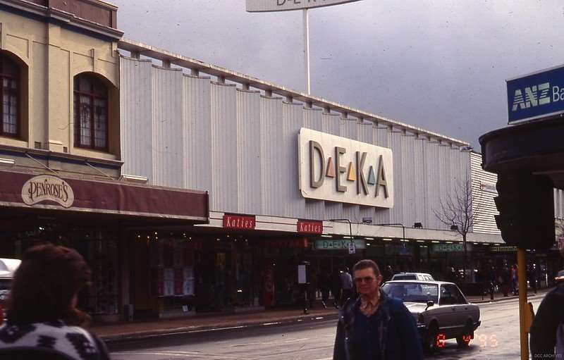
EXECUTIVE SUMMARY

Purpose of this report
The purpose of this report is to provide evidence to support the inclusion of Dunedin Corduroy
Causeway in the New Zealand Heritage List/Rārangi Kōrero as a Category 1 historic place.

Summary
Sometime between 1848 and 1859, a 12 metre-long, 4 metre-wide corduroy causeway was
constructed in central Dunedin to bridge an area of boggy ground in what was flax strewn marshland.
This rare surviving structure associated with the first decade of European settlement in Dunedin was
discovered in June 2008 following the demolition of the former Woolworths building on George Street,
prior to the development of the site for the current Wall Street Mall.1

Historically Kāi Tahu, who occupied the peninsula, used the tauraka waka at Ōtepoti (Dunedin city)
when they visited the head of the Ōtākou harbour.2 The soft slope of the foreshore and the tidal flats
in the upper harbour where the small stream, Toitū, entered the sea was bisected by a prominent hill
Ngā-moana-e-rua (called Bell Hill by colonists), the foot of which lay at the very edge of the high water
mark. No permanent kaik or villages were situated in the area of the causeway.3

The Dunedin Corduroy Causeway is a track constructed of cut timbers. This technique is known as a
‘corduroy’ which describes the ribbed surface formed by the close-set timbers that are laid across long
bearers aligned to the direction of the track. This created a walkway or road that could be used to
cross unstable ground relatively simply and quickly with resources at hand. Such track technology
dates to European prehistoric times with the earliest known corduroy track found in Germany, dating
to 4780 BC.4 The Dunedin Corduroy Causeway was built across a boggy depression at the foot of the
original hillside behind George Street and ran in a northwest–southeast direction at an irregular angle
to the line of street. The exposed track extended for 11m and was approximately 4m wide, but ran
into unexcavated ground at both ends, so was originally longer. The causeway was constructed
entirely from native timbers that were cut with an axe from the local hillside – no saws or nails were
used in its construction.5

1
  This report relies heavily on the work of Dr Peter Petchey.
2
  Kā Huru Manu http://www.kahurumanu.co.nz/atlas accessed 12 Dec 2019.
3
  M. Goodall & G. Griffiths., Māori Dunedin, Otago Heritage Books, Dunedin, 1980, p. 21.
4
  Peter Petchey, "First Footsteps in a New World City: The Dunedin Corduroy Causeway and Early Settlers’ Adaptation to
     Their New Home." Historical Archaeology 52.4, 2018, p. 709. https://doi.org/10.1007/s41636-017-0082-7
5
  P. G. Petchey, The Dunedin Corduroy Causeway Archæological Investigations at the Wall Street Mall Site George Street,
     Dunedin. Report on Archæological Investigations for Dunedin City Council. Archæological site I44/469 Archæological

                Heritage New Zealand Pouhere Taonga – List Entry Report for a Historic Place, List No. 9232               3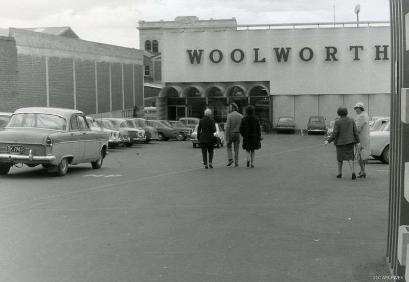
The track was carefully cleaned, recorded and approximately 40% of the timbers were lifted, to begin
the lengthy process of preservation. The remaining timbers were left in situ to be preserved by the
muddy deposits in which they were found. The Mall was subsequently constructed over the top. The
archaeological excavation and recording of the Dunedin Corduroy Causeway was led by Dr Peter
Petchey on behalf of Dunedin City Council and the owners of the Wall Street Mall. The Dunedin
Corduroy Causeway is of national significance. It is a site of outstanding archaeological and historical
value, and significant aesthetic and social value. It provides important evidence of Dunedin’s early
settlers’ attempts to utilise local resources to improve their experience of living and working in this
new landscape.

1.       IDENTIFICATION6
1.1.     Name of Place

          Name
          Dunedin Corduroy Causeway

          Other Names
          Corduroy causeway
          Timber corduroy causeway
          Wall Street

1.2.     Location Information

          Address
          211 George Street
          Dunedin Central
          Dunedin
          Otago

          Additional Location Information
          E 1406319 N 4917247 (NZTM)

    Authority No. 2007/354.
    https://www.academia.edu/7560945/The_Dunedin_Causeway._Archaeological_Investigations_at_the_Wall_Street_Mall
    _Site_Dunedin._Archaeological_Site_I44_469
6
  This section is supplemented by visual aids in Appendix 1 of the report.

               Heritage New Zealand Pouhere Taonga – List Entry Report for a Historic Place, List No. 9232         4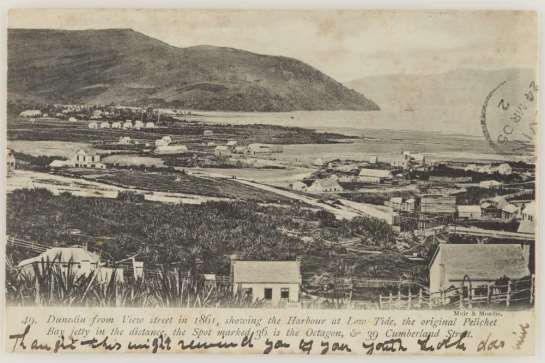
Local Authority
             Dunedin City Council

1.3.        Legal Description
            Lot 4 DP 17196 (RT OT15A/437), Otago Land District

1.4.        Extent of List Entry

            Extent includes part of the land described as Lot 4 DP 17196 (RT OT15A/437), Otago Land
            District and the structure known as Dunedin Corduroy Causeway thereon, and the following
            chattel: the section of the causeway reinstated in floor of Wall Street Mall for public display.
            (Refer to map in Appendix 1 of the List entry report for further information).

1.5.        Eligibility

            There is sufficient information included in this report to identify this place. This place is
            physically eligible for consideration as a historic place. It consists of an archaeological site and
            chattels that are fixed to land which lies within the territorial limits of New Zealand.

1.6.        Existing Heritage Recognition

             Local Authority and Regional Authority Plan Scheduling
             Not scheduled in Dunedin City Council District Plan, Operative 20 November 2019 [as
             amended].

             Other Protection Mechanism
             Subject to a 2008 court order requiring that the preserved remains of the causeway be
             returned to its original site for display.7

             New Zealand Archaeological Association Site Recording Scheme
             This place or sites within this place have been recorded by the New Zealand Archaeological
             Association. The reference is – I44/469.

2.          SUPPORTING INFORMATION

7
    See judgement CRI 2008-012-001105.

                  Heritage New Zealand Pouhere Taonga – List Entry Report for a Historic Place, List No. 9232      5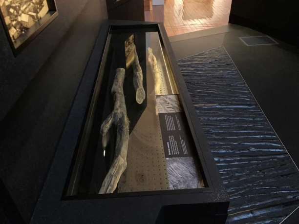
2.1.      Historical Information

           Early history
           Both iwi history and archaeological evidence show Māori occupation in the Otago region
           over an extended period, with the inhabitants utilising a wide variety of natural resources
           from the diverse environment. Archaeological evidence supports the date of earliest
           settlement around the 12th century.8

           Today, Kāi Tahu mana whenua is recognised over a large part of Te Wai Pounamu.9 Kāti
           Māmoe and Waitaha whakapapa and shared occupation are always acknowledged. Tūpuna
           such as Waitai, Tukiauau, Whaka-taka-newha, Rakiiamoa, Tarewai, Maru, Te Aparangi, Taoka,
           Moki II, Kapo, Te Wera, Tu Wiri Roa, Taikawa, and Te Hautapanuiotu are among Kāti Māmoe
           and Kāi Tahu tūpuna whose feats and memories are embedded in the landscape, bays, tides
           and whakapapa of Ōtākou Otago.10 The hapū Kai Te Pahi, Kāti Moki, and Kāti Taoka still
           maintain their presence and responsibility as kaitiaki in this region.

           Historically, Kāi Tahu used the tauraka waka at Ōtepoti (Dunedin city) when they visited the
           head of the Ōtākou harbour as either the gateway to the route to Kaikārae (Green Island) or
           when off on other mahinga kai expeditions.11 The soft slope of the foreshore and the tidal
           flats in the upper harbour where the small stream, Toitū, entered the sea was bisected by a
           prominent hill Ngā-moana-e-rua (called Bell Hill by colonists), the foot of which lay at the
           very edge of the high water mark. No permanent kaik or villages were situated at the mouth
           of the Toitū, simply because there was no need for it.12

           While not as densely populated as the North Island, numerous kaik in the Ōtākou region still
           hosted a good number of Waitaha, Kāti Mamoe and later Kāi Tahu peoples. Various bays and
           beaches around the Taiaroa Heads supported several hundred people with kaik in Karitāne,
           Waikouaiti and at the mouth of the Mata-au or Clutha hosting a similar number. Pā kāinga
           on the Ōtākou coast included Māpoutahi (Pūrākaunui), Pukekura (Taiaroa Head), Kōpūtai,

8
  Jill Hamel, The Archaeology of Dunedin, Department of Conservation, 2001, p. 11.
9
  Ngāi Tahu http://www.ngaitahu.iwi.nz/About-Ngai-Tahu/Ngai-Tahu.php accessed 12 Dec 2019.
10
   Kāi Tahu Ki Otago, Natural Resource Management Plan, 2005, https://aukaha.co.nz/wp-content/uploads/2019/08/kai-
      tahu-ki-otago-natural-resource-mgmt-plan-05.pdf accessed 12 Dec 2019
Te Rūnanga o Ōtakou http://www.otakourunaka.co.nz/our-harbour accessed 12 Dec 2019.
11
   Kā Huru Manu http://www.kahurumanu.co.nz/atlas accessed 12 Dec 2019.
12
   M. Goodall & G. Griffiths., Māori Dunedin, Otago Heritage Books, Dunedin, 1980, p. 21.

                Heritage New Zealand Pouhere Taonga – List Entry Report for a Historic Place, List No. 9232          6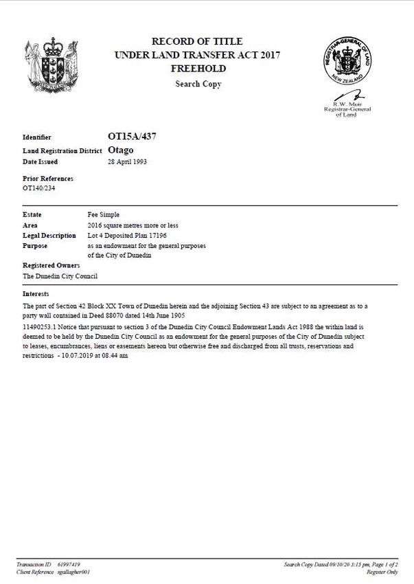
Huriawa and Moturata (Taieri Island). Whareakeake, one of several pounamu working sites,
           attested to another facet of lifestyle for the artisans of the iwi.13

           While the population numbers are still debated by academics and historians, there is no
           argument that through epidemics and intertribal warfare, the numbers of Kāi Tahu living in
           the region had dwindled considerably by the time the Treaty of Waitangi was signed at
           Ōtakou (Otago Heads) on 13 June 1840.14

           Early European settlement
           The first organised settlement of Dunedin was arranged between the Lay Association of the
           Free Church of Scotland and the New Zealand Company which bought land from Kāi Tahu in
           1844. The land was surveyed by Charles Kettle and his assistants in 1846, and in 1848 the
           first two ships of settlers arrived on the John Wickliffe and the Philip Laing. That same year,
           the Rev. Burns undertook a census and recorded 444 Europeans and 166 Māori residing in
           the area. Aside from the survey, little development of the city was complete and new
           settlers were required to construct their own dwellings.15 The majority of the early
           settlement was south of Bell Hill (known as Church Hill at the time of settlement) around the
           current Exchange. The swampy area north of Bell Hill was largely unoccupied (see Figure 3).
           In wet weather roads turned to quagmires, and Dunedin was known locally as "Mud-edin".
           Complaints were voiced about, "the swamp (with its ‘thick green slime’) on the northern
           flat” which came in for a considerable amount of attention.16 One early settler recounted
           later that as a child she had become lost among the flax bushes somewhere between St
           Andrew and Hanover Streets (see Figure 3).17 The track way that cut across the Wall Street
           site was a response to the muddy conditions.

           The use of the corduroy technique
           Petchey notes that while the Dunedin Corduroy Causeway is a uniquely significant
           archaeological find in New Zealand, it is not uncommon in the international context.18 The
           use of logs to form corduroy tracks and roads have a long history internationally; the

13
   Toitū Tauraka Waka, Dunedin (List No. 9774) https://www.heritage.org.nz/the-list/details/9774 accessed 12 Dec 2019.
14
   Treaty signatories and signing locations https://nzhistory.govt.nz/politics/treaty/nga-wahi-signing-occasions accessed 14
     Feb 2020.
15
   Petchey, 2018, p. 705. https://doi.org/10.1007/s41636-017-0082-7; Wellington Independent, 2 May 1849. p. 3.
16
   Petchey, 2010, p. 9.
17
   ‘Lost and Found in Mud-edin’. Otago Settlers News, March 2014, Issue 120, p. 1-2
     https://otagosettlers.org.nz/dmsdocument/37 accessed 30 October 2020.
18
   Petchey, 2018, p. 709.

                 Heritage New Zealand Pouhere Taonga – List Entry Report for a Historic Place, List No. 9232                   7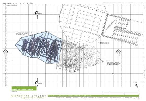
technology dates to European prehistoric times with the earliest known corduroy track found
           in Germany, dating to 4780 BC.19 Construction of a corduroy road was a relatively simple
           process, and made use of readily available local materials in order to provide a stable surface
           to cover an uneven or boggy terrain. In New Zealand, the practice continues to be utilised in
           the forestry sector; NZ Forestry defines a corduroy road as, “a structured load-bearing
           surface where logs are laid horizontally and parallel, with no void areas. Corduroy roads are
           an engineered road construction technique used in places where the substrate is very weak,
           and where the load must be spread if the road is to be trafficable…”.20

           Early writers in New Zealand often refer to ‘corduroy’ being an American term and have
           described the conditions where such a road was either encountered in swampy areas, or
           where the environment necessitated such a construction.21 The importance of creating such
           roads is described by G. Hamilton-Browne, “All this work fell very heavy on us, as the regulars
           were of but little use in the bush, either as axemen or coverers, but we should have made
           light of that had it not been for the rain, that not only drenched us but turned the soft loamy
           bush soil into liquid mud, in which we sank nearly to the knee, and forced us to corduroy the
           path so as to enable the wretched pack-horses to get any footing, while men, horses, packs,
           arms and everything soon became plastered and caked with mud.”22

           Corduroy tracks have been identified in New Zealand in a variety of different locations
           including in pastoral leases, and in areas exploited for both gold and coal mining.23 Records
           suggest the construction of a meter length of road could be achieved by hand in
           approximately one hour. 24 However an excellent description of the use of trees by Thomas

19
   ibid.
20
   NZ Forest Road Engineering Manual https://docs.nzfoa.org.nz/live/nz-forest-road-engineering-manual/forest-road-
     engineering-terminology/ accessed 19 September 2020.
21
   ‘General Chutes Last Dispatch’, in A Campaign on the West Coast of New Zealand, 1866, p. 40, via NZETC
     http://www.enzb.auckland.ac.nz accessed 16 October 2020; J. Alexander, Bush Fighting, 1893, p. 297, via NZETC
     http://www.enzb.auckland.ac.nz accessed 16 October 2020.
22
   G. Hamilton-Browne, With the Lost Legion in New Zealand, 1911, p. 119, via NZETC http://www.enzb.auckland.ac.nz
     accessed 16 October 2020.
23
   Katharine Watson, Historic Resources on the Rollersby and Glenrock Pastoral Leases. Unpublished Report for the
     Department of Conservation Canterbury Conservancy, 2009, p. 19.
     https://dl.heritage.org.nz/greenstone3/library/sites/heritage-nz/collect/pdf-
     reports/index/assoc/Watson71.dir/Watson71.pdf; R. McGovern-Wilson, Globe Hill Archaeological Survey, Prepared for
     Macraes Mining Company, 1992, p. 29. https://dl.heritage.org.nz/greenstone3/library/sites/heritage-nz/collect/pdf-
     reports/index/assoc/McGovern/9.dir/McGovern9.pdf
24
   Jack Blyth working in the 1930s, recalls it took about an hour to lay a metre of corduroy track, from cutting down the tree,
     splitting the logs and laying down the battens. Kaikawaka Villa (List No.7620) https://www.heritage.org.nz/the-
     list/details/7620.

                 Heritage New Zealand Pouhere Taonga – List Entry Report for a Historic Place, List No. 9232                      8
Florence, an experienced woodsman, details the difficulty of creating causeways in New
           Zealand swamps which have few trees. He opined that trees that were accessible were not
           suitable for splitting, and because they do not grow straight, are difficult to lay in course.25
           This is evident from the timbers recorded in the Dunedin Corduroy Causeway where less
           desirable resources were used to create a road over which to transport more suitable
           construction timbers like tōtara (see Table 1 and Figure 2).26

           Description of the Dunedin Corduroy Causeway
           The corduroy causeway was found in June 2008 during what was expected to be the last on-
           site archaeological work in one of the last areas of the Deka/Wall Street Mall site to be
           developed.27 The causeway was discovered 1.3m below the level of George Street in the
           approximate middle of the town block bounded by George, Filleul, Hanover, and St. Andrews
           streets (section 42 Block XX Dunedin). It was built across a boggy depression at the foot of
           the original hillside and ran in a northwest–southeast direction at an angle to the formal road
           and cadastral land boundaries. The exposed length extended for 11m and was approximately
           4 m wide. The causeway ran into unexcavated ground at both ends and so was originally
           somewhat longer.

           The causeway is constructed from a variety of timbers cut from the local bush with
           longitudinal runners with shorter timbers laid on top. The lowest section of the causeway, at
           the north-western end, was constructed in deep mud, and had three layers of timbers:
           several large cross-members, three longitudinal runners, and then the corduroy timbers on
           top. Timber sizes ranged from 150 mm in diameter for some of the largest base members,
           down to branches and brushwood along the corduroy. All the timbers were axe-cut, and no
           nails or other fastenings were used. Some of the runners had notches cut into their top
           surface to hold the corduroy timbers. Timber identifications were carried out by Dr Rod
           Wallace (University of Auckland).28 The most common timber excavated was kānuka (Kunzea
           ericoides), followed by māpau (Myrsine australis), with tangaru, kōhūhū , putaputawētā
           (Carpodetus serratus), māhoe (Melicytus ramiflorus) and rimu (Dacrydium cupressinum) also
           present (see Table 1). These species were all part of the forest that the first European settlers
           to Dunedin found covering the lower hillslopes. The sizes of the timbers ranged from 150mm
           down to small twigs. Beneath and between some of the logs were harakeke or flax

25
   Daily Southern Cross 5 Aug 1863, p. 4.
26
   Tōtara shingles were some of the earliest artefacts uncovered in the excavation of the causeway, see Petchey, 2010, p. 31.
27
   Petchey, 2010, p. 18.
28
   Dr Roderick Wallace http://www.arts.auckland.ac.nz/people/rwal071 accessed 23 Oct 2020.

                 Heritage New Zealand Pouhere Taonga – List Entry Report for a Historic Place, List No. 9232                    9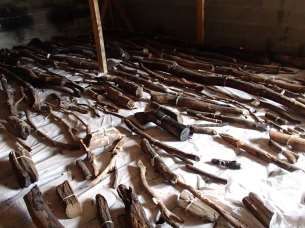
(Phormium tenax) leaves, indicating that the causeway had been laid across flax-covered
           ground (see Figure 3).29 A 100mm thick layer of fine, silty clay was deposited over the timbers
           which probably happened soon after its construction.30

          Table 1: Causeway and associated timbers and their common economic uses.31

       Botanical name         Māori name          Common                                 Economic Use
                                                    name                   Māori                            Colonial
       Kunzea:               Kānuka             White tea         Weapons, fencing                  Fencing, tool handles,
               32
       erioides                                 tree                                                wharf piles, firewood
       Mrysine               Māpou /            Red matipo        Medicinal, ceremonial,            Furniture, tools
                 33
       australis             Māpau                                hand tools
                    34
       Olearia sp.           Tanguru            Tree daisy

       Pittosporum           Kōhūhū             Black matipo      Adornment, medicinal,             Garden hedging,
           35
       sp.                                                        ceremonial                        ornamental trees
       Carpodetus            Putaputawētā       Marble leaf       Teka (foot rest on a kō /
                36
       serratus                                                   digging stick)
       Melicytus             Māhoe              Whitey            Medicinal, tattooing,             Charcoal making for
                   37
       ramiflorus                               wood              ceremonial, fire starting         gunpowder, fire
                                                                                                    lighting, stock food,
       Dacrydium             Rimu               Red pine          Medicinal, food, dyes,            House frames, weather
                    38
       cupressinium                                               tattooing, weapons, paint,        boards, sarking,
                                                                  toys                              finishing timber for
                                                                                                    doors, furniture
       Over causeway

       Podocarpus            Tōtara                               Medicinal, canoes, houses,        House piles, frames,
              39
       totara                                                     raised storehouses,               fence posts, telegraph
                                                                  storage vessels, carvings,        poles, railway sleepers,
                                                                  pā stockades                      bridges, roof shingles

           No artefactual material or evidence of other cultural activity was found beneath the
           causeway indicating its construction is likely to date to early in the period of European
           settlement. Overlying these layers was rubble fill. Only a few items date back to the first

29
   Petchey, 2010, p. 25.
30
   Petchey, 2018, p 705-6.
31
   This table describes the types of timbers recovered from the excavation site and details their general usage. The table has
    been Adapted from J. T. Salmon 1980 cited Petchey, 2018, p. 707, and further supplemented with information from
    Manaaki Whenua’s Ngā Tipu Whakaoranga Māori Plant Use database https://maoriplantuse.landcareresearch.co.nz/
    accessed 2 July 2020.
32
   Ngā Tipu Whakaoranga Record 3714.
33
   Ngā Tipu Whakaoranga Record 1159.
34
   Ngā Tipu Whakaoranga Record 1167.
35
   Ngā Tipu Whakaoranga Record 1181.
36
   Ngā Tipu Whakaoranga Record 1501.
37
   Ngā Tipu Whakaoranga Record 1157.
38
   Ngā Tipu Whakaoranga Record 1082.
39
   Ngā Tipu Whakaoranga Record 1125.

                 Heritage New Zealand Pouhere Taonga – List Entry Report for a Historic Place, List No. 9232                     10
decade of settlement when that part of the North Dunedin flat remained a swampy morass
that the pioneers travelled over with difficulty.40
History of the site
Following the gold rush in 1861 Central Dunedin developed rapidly from a muddy wasteland
to a bustling commercial and industrial centre with the incremental development of the city
infrastructure. People lived amongst the shops and workshops, creating a vibrant if hidden
community life in behind the retail frontage of George Street.
The 1857 Dunedin Town Rates Book index records John Curle and David Hutchison as owners
and occupiers of Block XX Sec 42 during 1857 and 1858 on which there was a dwelling house
and a garden. Curle owned a lot of property in the area and is first mentioned as a tin plate
worker.41 In 1859, Block XX section 42 was owned by George Mathew. There follows a gap in
records until 1875, a busy period for the city which expanded rapidly during the gold rush
which began in 1861, when Block XX section 42 is recorded as being owned by A. Fulton who
had a factory, timber yard, premises and a house, indicating a mix of uses of the area ranging
from residential to commercial. A photo from 1879 confirms the timber yard and dwelling
(see Figure 4, Figure 5). J. Wilke’s lithograph of Dunedin in 1898 shows the open area and
structures suggested both in the earlier photo and in DP 1763 in 1905 (Figure 6).42 In 1888
and 1892 section 42 was still an open yard but was owned by A. Cornwall, a butcher. These
layers of overfill relate to the changing use of the area over time: an open garden or yard in
the 1860s–1870s, a two-story stable by 1888, and then the 1967 site development.43 Most of
the artefacts recovered from the Wall Street site date from the 1860s and 1870s when this
area of George Street was first developed with shops, workshops and cottages.44 The pre
1880 archaeological evidence presents a great deal of glassware, black alcohol bottles (beer
and whisky) being the predominant type in the assemblage, along with pickle and condiment
bottles.45
40
Seán Brosnahan, Information Brief for Manuka Causeway, 2012, p. 6.
41
DCC Town Board Rates Book Index 1857-1862; Otago Witness, 24 Feb 1855 via Otago Nominal Index
https://www.otago.ac.nz/library/hocken/oni/basic.php accessed 30 Oct 2020.
42
J. Wilkie & Co.,1898, Dunedin 1898 [lithograph]. Alexander Turnbull Library, Wellington, New Zealand.
https://ndhadeliver.natlib.govt.nz/delivery/DeliveryManagerServlet?dps_pid=IE491425 accessed 30 October 2020.
43
Petchey, 2018, p. 705-6.
44
Seán Brosnahan, Information Brief for Manuka Causeway, 2012, p. 6.
45
Petchey, 2010, pp. 59-61.
Heritage New Zealand Pouhere Taonga – List Entry Report for a Historic Place, List No. 9232 11In 1927 the yard is still evident but now utilised by tradesmen (plumber, painters and a
builder). In 1967 Woolworths was built and section 42 became a sealed carpark (see Figure
10 and Figure 11).46 It remained so until the excavation and development of the Wall Street
Mall in 2008.
Associated List Entries
None
2.2. Physical Information
Current Description
Of the original 12 x 4 metres of causeway that was excavated, the majority (60%) was too
deteriorated to be preserved and remains in situ under a layer of geotextile, beneath the
foundations of the Wall Street Mall complex and is a registered archaeological site.47 The
remaining timbers identified for preservation were tagged and were immersed in water
before conservation treatment was initiated under the direction of Dily Johns of the
Anthropology Department, University of Auckland.48 The timbers spent years soaking in a
solution of polyethylene glycol (PEG) prior to gradual drying.49 During the intervening years,
display options were discussed and designed.50
Meanwhile, Toitū Otago Settlers Museum developed the Ghosts of Wall Street exhibition, a
“time tunnel” experience that displays a number of artefacts, including a few pieces of the
causeway.51
46
For more detail refer to Petchey, 2010, p. 10-15.
47
Hamish McNeilly, Rot sinks plan for causeway, ODT, 16 Aug 2008 https://www.odt.co.nz/news/dunedin/rot-sinks-plans-
causeway accessed 30 October 2020.
48
Petchey, 2010, p. 23; David Loughrey, $310,000 bill to save 40% of causeway, ODT, 20 Aug 2008
https://www.odt.co.nz/news/dunedin/310000-bill-save-40-causeway accessed 30 October 2020.
49
Chris Morris, Timbers Stay Submerged, ODT, 30 Sep 2009 https://www.odt.co.nz/news/dunedin/timbers-stay-submerged
accessed 3 November 2020; Chris Morris, More time needed to treat causeway, ODT, 10 Sep 2011
https://www.odt.co.nz/news/dunedin/more-time-needed-treat-causeway accessed 3 November 2020; Chris Morris,
Display only weeks off, ODT, 31 July 2012 https://www.odt.co.nz/news/dunedin/display-only-weeks accessed 3
November 2020;
50
Chris Morris, Manuka display options being investigated, ODT, 20 June 2018
https://www.odt.co.nz/news/dunedin/dcc/manuka-display-options-being-investigated accessed 3 November 2020.
51
John Gibb, Exhibition aims to bring Dunedin's past to life, ODT, 24 Oct 2013,
https://www.odt.co.nz/news/dunedin/exhibition-aims-bring-dunedins-past-life accessed 8 October 2020; John Gibb,
Exhibition brings past to life, ODT, 28 Dec 2013 https://www.odt.co.nz/news/dunedin/exhibition-brings-past-life
accessed 8 October 2020.
Heritage New Zealand Pouhere Taonga – List Entry Report for a Historic Place, List No. 9232 12The remaining 40% of the causeway will be installed in an excavated space in the floor of
Wall Street Mall directly above the location of the excavation site (see
Figure 13, Figure 14, and Figure 15). The area created will be designed to museum
conservation standards.52 The timbers will be set back in their original positions within a
stable form and surrounded with inert material to simulate the clay that would have been
packed in around the timbers at time of use.53 The installation will be comprehensively
interpreted.
Comparative analysis
There is no adequate comparator with the Dunedin Corduroy Causeway in New Zealand. A
William Meluish photo (reprinted by Burton Brothers) of Lower High Street in 1859 shows a
corduroy footpath in front of a row of small businesses which provides some indication of
52
The following is summarised from letter from Dily Johns., Parameters to consider for display/storage of the treated
Dunedin causeway timbers, 17 March 2011. Dunedin Office file: 22010-030. Stable temperature of 18-20°C, RH 50%,
Cool/cold lighting- 150-200 lux maximum with lights off when mall is closed, controlled ventilation, regular monitoring for
pest infestation, fire prevention – summary from letter from Dily Johns., Parameters to consider for display/storage of the
treated Dunedin causeway timbers, 17 March 2011. Dunedin Office file: 22010-030.
53
Email from Andrea Farminer, DCC 17 November 2020 “The materials include: styrofoam polystyrene, water-based
adhesive, minimal but necessary polyurethane foam, plaster of Paris, hessian, oxides, finished with scenic flat paints, sand
and p.v.a., and water-based paints.”
Heritage New Zealand Pouhere Taonga – List Entry Report for a Historic Place, List No. 9232 13what the causeway may have looked like.54 There are a small number of archaeological sites
and Heritage New Zealand listings that include corduroy roads.
Big River Quartz Mine (List No. 7762)55
The West Coast’s Big River Road dates to the 1880s and was built of large logs. Some of the
logs that formed the corduroy base are still visible along parts of the road. This road is later
than the Dunedin Corduroy Causeway but only partially viewable. The style of corduroy road
appears to be different, using larger materials more suitable for the conveyance of heavy
machinery.
Alpha Mine NZAA No. B46/42
The site on Auckland’s North Shore is reached by climbing up from Te Oneroa to the top of
the escarpment behind Long Beach, and then following the old Alpha corduroy sled track.
The track dates to 1895 and at the time of assessment could still be found but was very
overgrown.56 While the Alpha corduroy track is extant, it dates later than the Dunedin
Corduroy Causeway and was constructed for industrial purposes.
Makatote Tramway (List No. 7668)57
The North Makatote Tramway site consists of a branching network of tramlines. There are
both wooden and metal rails, as well as a corduroy track in the northwest of the site. Whilst
no conclusive comments can be drawn about the sequence of construction, historical
documents indicate that the "the whole of the left hand branch and part of the right hand
branch towards the eastern extremity" were constructed by the Dinwoodie Timber Company
(1934-1939). This site is significantly later than the Dunedin causeway, and like the other
comparative sites, is situated in an industrial context, quite different to the Dunedin Corduroy
Causeway constructed within a kilometre of the settlement.
Construction Professionals
Unknown
54
William Meluish, 1859, High Street, Dunedin [photograph], MNZ-0364-1/4-F Alexander Turnbull Library, Wellington, New
Zealand https://tiaki.natlib.govt.nz/#details=ecatalogue.557159 accessed 30 October 2020.
55
Big River Quartz Mine (List No. 7762) https://www.heritage.org.nz/the-list/details/7762
56
P.G. Petchey., Morning Star Mine. Golden Site Mine. Alpha Mine. Preservation Inlet. Archaeological Survey for the
Department of Conservation, 2005, p. 16-17 https://dl.heritage.org.nz/greenstone3/library/sites/heritage-nz/collect/pdf-
reports/index/assoc/Petchey6/3.dir/Petchey63.pdf
57
Makatote Tramway (List No. 7668) https://www.heritage.org.nz/the-list/details/7668
Heritage New Zealand Pouhere Taonga – List Entry Report for a Historic Place, List No. 9232 14Construction Materials
Timber
Key Physical Dates
1848-1859 Construction of the corduroy road
1860-1870 Open yard
1888 Double storey stable
1967 Woolworths site
2007 DEKA site demolished for development
2008 Excavation of the corduroy road
2009 Wall Street Mall completed over archaeological site
2013 Pieces of the causeway are installed in Ghosts of Wall Street exhibit at Toitū
Otago Settlers Museum
2021 Installation of a large section of the causeway, and interpretation in Wall
Street Mall
Uses
Transport – Road (Former)
Heritage New Zealand Pouhere Taonga – List Entry Report for a Historic Place, List No. 9232 152.3. Chattels
This List entry includes the following chattels that contribute to the heritage significance of
the place.
Section of preserved causeway
A four metre section was removed
from site and underwent two years of
preservation treatment. It was
reinstated in Wall Street Mall in April
2021 with interpretation.
Preserved timbers from the causeway in storage.
Photo: Dr Matthew Schmidt, 2019.
2.4. Sources
Sources used in the researching of this report have strongly relied on the reports and articles
produced by Dr Peter Petchey, and research compiled by Seán Brosnahan for Toitū Otago
Settlers Museum’s Ghosts of Wall Street exhibition, and a variety of newspaper articles.
Further Reading
Petchey, P.G. The Dunedin Corduroy Causeway Archæological Investigations at the Wall Street
Mall Site George Street, Dunedin. Report on Archæological Investigations for Dunedin City
Council. Archæological site I44/469 Archæological Authority No. 2007/354.
https://www.academia.edu/7560945/The_Dunedin_Causeway._Archaeological_Investigations
_at_the_Wall_Street_Mall_Site_Dunedin._Archaeological_Site_I44_469
Petchey, Peter. "First Footsteps in a New World City: The Dunedin Corduroy Causeway and
Early Settlers’ Adaptation to Their New Home." Historical Archaeology 52.4 (2018): 700-716.
https://doi.org/10.1007/s41636-017-0082-7
Heritage New Zealand Pouhere Taonga – List Entry Report for a Historic Place, List No. 9232 16“Lost and Found in Mud-edin,” Otago Settlers’ News, March 2014, Issue 120, pp. 1-2.
https://otagosettlers.org.nz/dmsdocument/37
Seán Brosnahan – research notes for Toitū Otago Settlers’ Museum Wall Street exhibition
[unpublished material].
3. SIGNIFICANCE ASSESSMENT58
3.1. Section 66 (1) Assessment
This place has been assessed for, and found to possess aesthetic, archaeological, historical
and technological significance or value. It is considered that this place qualifies as part of
New Zealand’s historic and cultural heritage.
Aesthetic Significance or Value
The Dunedin Corduroy Causeway has special aesthetic significance. While the remains in the
ground are unseen, the reinstated portion and photographic record and interpretation of the
site capture the rugged simplicity of this utilitarian road. One can imagine workers cutting the
timber from the local hillside, laying the bearers and crossbeams across the muddy ground
and imagine how those timbers must have felt under the feet of early settlers. The
installation at Wall Street Mall brings this to life.
Archaeological Significance or Value
The Dunedin Corduroy Causeway has outstanding archaeological significance at a national
level. It has provided evidence of early settlers’ lives and activities that has informed the
record of information about early Dunedin. This is the earliest example of a substantial
corduroy road in New Zealand. There is also potential for the in situ remains to further
enhance our understanding of this early European adaptation to terrain.
Historical Significance or Value
The Dunedin Corduroy Causeway has outstanding historical significance. Having been
identified as being constructed in the first decade of European settlement in Ōtepoti, the use
of timbers shows evidence of the settlers’ understanding of the qualities of wood types
available in the environment, and other artefactual material found in and around the
58
For the relevant sections of the Heritage New Zealand Pouhere Taonga Act 2014 see Appendix 4: Significance Assessment
Information.
Heritage New Zealand Pouhere Taonga – List Entry Report for a Historic Place, List No. 9232 17causeway have revealed information about the later business and activities that people who
lived in the area were engaged in.
Technological Significance or Value
The Dunedin Corduroy Causeway has special technological significance. As a widely used
method to deal with unbroken land with no infrastructure, the corduroy technique of
creating roads has a long history internationally and continues to be used today in forestry.
The importance of the Dunedin Corduroy Causeway is demonstrated in its size, innovations in
technique required through the utilisation of undesirable materials, and use in the
developing town situated in a boggy area.
3.2. Section 66 (3) Assessment
This place was assessed against the Section 66(3) criteria and found to qualify under the
following criteria: a, c, e, f, g, I, j, k. The assessment concludes that this place should be listed
as a Category 1 historic place.
(a) The extent to which the place reflects important or representative aspects of New
Zealand history
This place reflects significant insight into the conditions experienced by early settlers in
Dunedin and how they adapted to their new environment by making use of the local
resources to construct a causeway to enable easier passage across the land.
(c) The potential of the place to provide knowledge of New Zealand history
This place continues to be an outstanding source of information that has contributed to
the knowledge of New Zealand history. Its discovery has informed works of scholarship
and the Ghosts of Wall Street exhibit at Toitū Otago Settlers Museum. The academic
papers and interpretation of artefactual material sheds light on the lives of people who
inhabited the area around the causeway, and the causeway itself shows us that the
settlers were familiar with the best uses of different species of wood for construction. The
return of timbers to the Wall Street site in an accessible display with interpretation will
continue to share this information to the public.
(e) The community association with, or public esteem for the place
Heritage New Zealand Pouhere Taonga – List Entry Report for a Historic Place, List No. 9232 18There is a special community association and esteem for the place, largely thanks to the
work of Toitū Otago Settlers Museum who installed a permanent exhibit based around
records of people who lived near the causeway that have been interpreted with artefacts
recovered from the site.
(f) The potential of the place for public education
This place has outstanding opportunities to educate the public. Artefacts recovered from
and stories inspired by this site have been well received at Toitū Otago Settlers Museum
since 2013. Further commitment by the Dunedin City Council will see a preserved section
of the causeway returned to site in the Wall Street Mall with complimentary
interpretation.
(g) The technical accomplishment, value, or design of the place
This place is an outstanding example of the techniques utilised by early settlers to
construct roads with limited resources for the conveyance of people and resources over
difficult terrain in the first decade of settlement in Dunedin.
(i) The importance of identifying historic places known to date from an early period of New
Zealand settlement
This place is of outstanding importance through its contribution to knowledge about the
first decade of colonial settlement in Dunedin.
(j) The importance of identifying rare types of historic places
This place is an outstanding example of an early corduroy road in New Zealand, it is a
unique remaining example from this period.
(k) The extent to which the place forms part of a wider historical and cultural area
This place provides a rich source of information about the behaviours and knowledge of
early settlers within the wider historical and cultural area of early Dunedin, and their
adaptation to the land.
Summary of Significance or Values
The Dunedin Corduroy Causeway is an archaeological site of outstanding significance. An
example of temporary road construction from the earliest years of Dunedin’s settlement it is
of national significance. Its outstanding historical value, and special technological and
Heritage New Zealand Pouhere Taonga – List Entry Report for a Historic Place, List No. 9232 19aesthetic values identify ensure it is a place that will continue to be an archaeological site
and artefact of ongoing educational and cultural value to New Zealanders.
Heritage New Zealand Pouhere Taonga – List Entry Report for a Historic Place, List No. 9232 204. APPENDICES
4.1. Appendix 1: Visual Identification Aids
Location Maps
Dunedin
Heritage New Zealand Pouhere Taonga – List Entry Report for a Historic Place, List No. 9232 21Maps of Extent
Part of Lot 4 DP 17196, Otago Land District, the approximate location of the archaeological site and
installation are indicated in red.
Heritage New Zealand Pouhere Taonga – List Entry Report for a Historic Place, List No. 9232 22Current Identifier
Heritage New Zealand Pouhere Taonga – List Entry Report for a Historic Place, List No. 9232 23Heritage New Zealand Pouhere Taonga – List Entry Report for a Historic Place, List No. 9232 24
4.2.   Appendix 2: Visual Aids to Historical Information

       Historical Plans

       Figure 1: Central Dunedin, showing the location of the 2008 excavation in relation to the old inlet that was filled
       in the late 1860s. (Peter Petchey, 2017.) in Petchey, 2018 p. 702.

            Heritage New Zealand Pouhere Taonga – List Entry Report for a Historic Place, List No. 9232                      25
Figure 2: Plan of the Dunedin Corduroy Causeway. Field drawing by Maria Butcher and Peter Petchey, 2010.
Petchey 2018, p. 704.
Historical Photographs
Figure 3: Looking north from View Street across the flax festooned swamp lands, the likes of which the causeway
was built over, c.1861. Muir and Moodie Studio, 1900-1903. Collection of Te Papa.
https://collections.tepapa.govt.nz/object/320810
Heritage New Zealand Pouhere Taonga – List Entry Report for a Historic Place, List No. 9232 26Figure 4: View to the north of the block bounded by Filleul Street, St Andrews Street, and George Streets. Detail below (red).
Dunedin Panorama, Burton Brothers Studio, 1874. Collection of Te Papa. https://collections.tepapa.govt.nz/object/21340
Figure 5: Timber yard and two-storey stables indicated with arrows.
Heritage New Zealand Pouhere Taonga – List Entry Report for a Historic Place, List No. 9232 27Figure 6: DP 1763 shows the buildings on section 42 in 1905, namely an iron shed facing Filleul Street, and brick stables in the
middle of the section along the boundary with sections 41 and 71.
Heritage New Zealand Pouhere Taonga – List Entry Report for a Historic Place, List No. 9232 28Figure 7: Council of Fire and Accident Underwriters, 1927, Hocken Collections, University of Otago. Approximate location of
the causeway is indicated in red.
Figure 8: Retrolens 1942 – open area and small buildings still evident. Approximate location of the causeway is indicated in
red.
Heritage New Zealand Pouhere Taonga – List Entry Report for a Historic Place, List No. 9232 29St Andrew Street
Figure 9: Retrolens 1962 - open area and small buildings still evident. Approximate area of the causeway indicated in red.
St Andrew Street
Figure 10: Retrolens 1979 - open area and small buildings still evident. Approximate area of the causeway indicated in red.
Heritage New Zealand Pouhere Taonga – List Entry Report for a Historic Place, List No. 9232 30Figure 11: Woolworths Carpark, 1972. Dunedin City Council Archives, City Planning Series Photo Album "North Dunedin
c.1972-3. https://www.flickr.com/photos/dccarchives/34907941651/
Figure 12: Deka Building on George Street, 1995. Dunedin City Council Archives, Architect Photo Slide Series.
Heritage New Zealand Pouhere Taonga – List Entry Report for a Historic Place, List No. 9232 314.3. Appendix 3: Visual Aids to Physical Information
Current Plans
Figure 13: Design brief for the reinstallation of a section of the timber corduroy causeway within the Wall Street Mall site.
McAuliffe Stevens Manuka Causeway Reinstatement at Wall Street Mall for Dunedin City Council, 2020, Sheet 2.
Figure 14: Design brief for the reinstallation of a section of the timber corduroy causeway within the Wall Street Mall site.
McAuliffe Stevens Manuka Causeway Reinstatement at Wall Street Mall for Dunedin City Council, 2020, Sheet 4.
Heritage New Zealand Pouhere Taonga – List Entry Report for a Historic Place, List No. 9232 32Figure 15: Design brief for the reinstallation of a section of the timber corduroy causeway within the Wall Street Mall site.
McAuliffe Stevens Manuka Causeway Reinstatement at Wall Street Mall for Dunedin City Council, 2020, Sheet 8.
Heritage New Zealand Pouhere Taonga – List Entry Report for a Historic Place, List No. 9232 33Current Photographs of Place
Figure 16: Pieces of the Dunedin Corduroy Causeway on display in Toitū Otago Settlers Museum exhibition, Ghosts
of Wall Street. These items are registered interim donations: IR 10/35, D207, 1795; IR 10/35, Between D222 &
D206, 1742; IR 10/35, D203, 1738. Photo: Seán Brosnahan, Toitū Otago Settlers Museum, November 2020.
Heritage New Zealand Pouhere Taonga – List Entry Report for a Historic Place, List No. 9232 344.4. Appendix 4: Significance Assessment Information
Part 4 of the Heritage New Zealand Pouhere Taonga Act 2014
Chattels or object or class of chattels or objects (Section 65(6))
Under Section 65(6) of the Heritage New Zealand Pouhere Taonga Act 2014, an entry on the
New Zealand Heritage List/Rārangi Kōrero relating to a historic place may include any chattel
or object or class of chattels or objects –
a) Situated in or on that place; and
b) Considered by Heritage New Zealand Pouhere Taonga to contribute to the significance of
that place; and
c) Proposed by Heritage New Zealand Pouhere Taonga for inclusion on the New Zealand
Heritage List/Rārangi Kōrero.
Significance or value (Section 66(1))
Under Section 66(1) of the Heritage New Zealand Pouhere Taonga Act 2014, Heritage New
Zealand Pouhere Taonga may enter any historic place or historic area on the New Zealand
Heritage List/Rārangi Kōrero if the place possesses aesthetic, archaeological, architectural,
cultural, historical, scientific, social, spiritual, technological, or traditional significance or
value.
Category of historic place (Section 66(3))
Under Section 66(3) of the Heritage New Zealand Pouhere Taonga Act 2014, Heritage New
Zealand Pouhere Taonga may assign Category 1 status or Category 2 status to any historic
place, having regard to any of the following criteria:
a) The extent to which the place reflects important or representative aspects of New
Zealand history
b) The association of the place with events, persons, or ideas of importance in New Zealand
history
c) The potential of the place to provide knowledge of New Zealand history
d) The importance of the place to tangata whenua
e) The community association with, or public esteem for, the place
f) The potential of the place for public education
g) The technical accomplishment, value, or design of the place
h) The symbolic or commemorative value of the place
Heritage New Zealand Pouhere Taonga – List Entry Report for a Historic Place, List No. 9232 35i) The importance of identifying historic places known to date from an early period of New
Zealand settlement
j) The importance of identifying rare types of historic places
k) The extent to which the place forms part of a wider historical and cultural area
Summary of Significance or Values
Additional criteria may be prescribed in regulations made under this Act for the purpose of
assigning Category 1 or Category 2 status to a historic place, provided they are not
inconsistent with the criteria set out in subsection (3)
Additional criteria may be prescribed in regulations made under this Act for entering historic
places or historic areas of interest to Māori, wāhi tūpuna, wāhi tapu, or wāhi tapu areas on
the New Zealand Heritage List/Rārangi Kōrero, provided they are not inconsistent with the
criteria set out in subsection (3) or (5) or in regulations made under subsection (4).
NOTE: Category 1 historic places are ‘places of special or outstanding historical or cultural
heritage significance or value.’ Category 2 historic places are ‘places of historical or cultural
heritage significance or value.’
Heritage New Zealand Pouhere Taonga – List Entry Report for a Historic Place, List No. 9232 36You can also read