WEST WEALD LANDSCAPE PROJECT SUSSEX & SURREY HISTORIC LANDSCAPE CHARACTERISATION PROJECTS ANALYSIS
←
→
Page content transcription
If your browser does not render page correctly, please read the page content below
WEST WEALD LANDSCAPE PROJECT
 SUSSEX & SURREY HISTORIC LANDSCAPE
CHARACTERISATION PROJECTS ANALYSIS

                                             by
                               Dr Nicola R. Bannister
                  SUSSEX HISTORIC LANDSCAPE CHARACTER PROJECT OFFICER

  Surrey Historic Landscape Characterisation Project (2001): Joint Partnership between Surrey
                County Council, English Heritage and the Countryside Agency
Sussex Historic Landscape Characterisation Project (2003-2008): Joint Partnership between West
 Sussex County Council, East Sussex County Council, Brighton and Hove Unitarian Authority,
                                    and English Heritage
SUSSEX HLC
WEST WEALD LANDSCAPE ANALYSIS
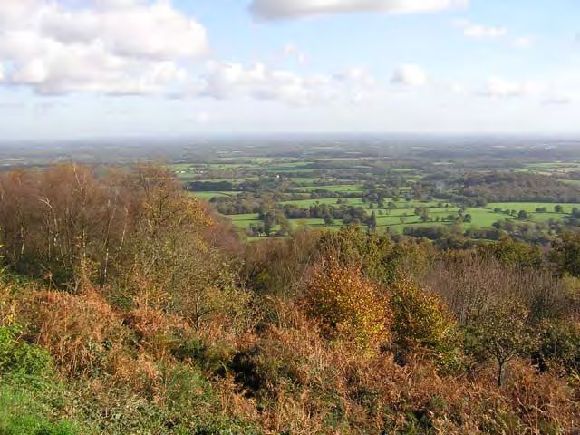
Cover images: the West Weald Landscape from Black Down in 1943-44 (top) and 2006 (bottom)
– supplied courtesy of Andy Tate and David Elliott (National Trust) respectively.
CONTACTS
DR NICOLA R. BANNISTER
(Landscape, History & Conservation)
SUSSEX HLC Project Officer
Ashenden Farm
Bell Lane, Biddenden
Ashford, Kent. TN27 8LD
TEL/FAX (01580) 292662
ashenden@supanet.com
MR BOB CONNELL (Senior Planner)
Sussex HLC Project Manager
Environment and Planning Services
West Sussex County Council
The Grange, Tower Street,
Chichester, PO19 1RH
TEL (01243) 777040
Bob.connell@westsussex.gov.uk
MR RICH HOWORTH West Weald Landscape Project Manager
SUSSEX WILDLIFE TRUST
Woods Mill
Henfield, West Sussex
BN5 9SD
TEL (01273) 492630
Richhoworth@sussexwt.org.uk
October 2006
The views and opinions expressed in this report are the author’s own and do not necessarily accord with those of the Sussex Wildlife
Trust or West Sussex County Council.
The report has been written to a prepared brief and should be consulted only in the context of an archaeological and historic
landscape survey. The report does not constitute a legal document.
All Geographic Information System (GIS) generated data and maps in this report have been provided by kind permission of the parent
authorities of West Sussex County Council, East Sussex County Council and Brighton & Hove Unitary Authority with whom the
copyright (c) resides.
Copyright
All rights reserved. No part of this document may be reproduced, stored in a retrieval system, or transmitted in any form or by
any means, electronic, mechanical, photocopying, recording or otherwise, without the prior permission of West Sussex County Council & N.R.Bannister
- ii -
N.R.BANNISTER SUSSEX HLC PO October 2006
© West Sussex County Council & N.R.BannisterSUSSEX HLC
WEST WEALD LANDSCAPE ANALYSIS
CONTENTS
GLOSSARY, ABBREVIATIONS & PERIOD TABLE
1. INTRODUCTION 001
1.1. AREA OF ANALYSIS
1.2. THE ANALYSIS
2. PRINCIPLES OF HLC 002
2.1. SURREY HLC MAP
2.2. SUSSEX HLC MAP
3. BACKGROUND DESCRIPTION OF THE STUDY AREA 003
3.1. GEOLOGY
3.2. HISTORIC CONTEXT
4. THE ANALYSIS 004
4.1. HLC BROAD TYPES
4.2. FIELDSCAPES
i. ASSART FIELDS 005
ii. INFORMAL FIELDS 006
iii. FORMAL FIELDS
4.3. WOODLAND 007
i ANCIENT SEMI-NATURAL WOODLAND
ii. REGENERATED WOODLAND
iii. PLANTATION WOODLAND
4.4. UNENCLOSED/UNIMPROVED 008
4.5. SETTLEMENT 009
4.6. DESIGNED LANDSCAPES 010
4.7. MORE DETAILED ANALYSIS OF THE SUSSEX/SURREY HLC MAPS
4.8. ‘TIME-DEPTH’ OF PRESENT LANDSCAPE
i PRE-1800 HLC TYPES
ii. POST-1800 HLC TYPES
4.9. BOUNDARY LOSS 012
i. PRE-1800 HLC TYPES – SUSSEX ONLY
ii. POST-1800 HLC TYPES – SUSSEX ONLY
4.10. PROBABLE MEDIEVAL HISTORIC LANDSCAPE CONTINUITY
5. SUMMARY INTERPRETATION OF PROCESSES OF HISTORIC LANDSCAPE
DEVELOPMENT IN THE WEST WEALD 013
5.1. PREHISTORIC
5.2. ROMANO-BRITISH
5.3. EARLY MEDIEVAL OR ANGLO-SAXON
5.4. MEDIEVAL 014
5.5. EARLY POST-MEDIEVAL 015
5.6. LATE POST-MEDIEVAL 016
5.7. MODERN
6. FURTHER ANALYSIS
7. REFERENCES 017
APPENDIX I - SURREY HISTORIC LANDSCAPE TYPES & SUBTYPES 018
APPENDIX II – COMPARISON OF SURREY & SUSSEX HLC SUBTYPES 021
- iii -
N.R.BANNISTER SUSSEX HLC PO October 2006
© West Sussex County Council & N.R.BannisterSUSSEX HLC
WEST WEALD LANDSCAPE ANALYSIS
GLOSSARY & ABBREVIATIONS
ASN = Ancient Semi-Natural
Assart = land cleared and enclosed from woodland or waste
Assart Woodland = woodland left after fields have been enclosed
Balk = grassy earthwork bank dividing fields
Bloomery = furnace in which iron ore was heated with
charcoal to extract iron metal
EWGS = England Woodland Grant Scheme, administered by the
Forestry Commission
Field walking = systematic collection of artefacts from cultivated soil
GIS = Geographical Information System
Ha = hectares
HER = Heritage Environment Records
Lynchet = step-like bank of former boundaries found on sloping
ground and formed by the down-slope movement of soil
during cultivation
Messuage = a building or domestic property
OE = Old English
OS = Ordnance Survey
OSD = Ordnance Survey Datum
Purpresture = piece of private land taken out of an area of common or
waste land, or out of the width of a road
PAWS = Plantations on Ancient Woodland Sites
SMR = Sites and Monuments Record
Teller = young trees in coppice woods left to grow into standards
PERIOD TABLE
Description Archaeological Period From To
Hunting societies Upper Palaeolithic 30,000 10,000 BC
Hunter-gather societies Mesolithic 10,000-8,000 4,000-3,500 BC
The first agriculturalists Neolithic 3,500 2,100 BC
The beginning of metal working Bronze Age 2,100 600 BC
in bronze
The beginning of metal working in iron Iron Age 600 BC AD 43
Romano-British AD 43 AD 410
Anglo-Saxons [or Early Medieval] AD 410 1066
Medieval 1066 1540
Post-medieval 1540 Present
- iv -
N.R.BANNISTER SUSSEX HLC PO October 2006
© West Sussex County Council & N.R.BannisterSUSSEX HLC
WEST WEALD LANDSCAPE ANALYSIS
WEST WEALD
HISTORIC LANDSCAPE CHARACTER ANALYSIS
1. INTRODUCTION
The West Weald Landscape Project covers 240 square kilometres (60,000
acres) at the western end of the Low Weald, near Petworth. It is a landscape
dominated by woodland much of it ancient. It is a rich landscape for wildlife
with two internationally important examples of old-growth forest and
pasture woodland at The Mens and Ebernoe Common. Their traditional
management probably dates from at least the Saxon period.
The aim of the West Weald Landscape Project [WWLP] is to encourage
positive land use management which will encourage connectivity of woody
hedges, woodland corridors, wetlands and less intensive forms of farming
and forestry management to benefit many of the rare species of wildlife that
live in this forested landscape1.
As part of the WWLP, baseline report is being prepared by the Sussex
Wildlife Trust. A wide range of data is being collected, not only on the natural
history but the social and cultural background to the West Weald. The
following analysis of the Sussex Historic Landscape Characterisation Map
forms one of the cornerstones of baseline report. It provides the historic
context and time-depth for the landscape and gives an indication of
traditional land use processes which have shaped the present landscape.
1.1. Area of Analysis
The area included in the analysis lies at the western end of the Low Weald
landscape character area2. It is bounded on the eastern side by the valley of
the River Arun and the western side by the edge of the hills formed by the
Lower Greensand formations. This boundary edge swings round south east
to form the southern boundary north of Midhurst and through Petworth. The
northern part of the study area extends into Surrey to include the wooded
landscapes around Chiddingfold and Dunsfold. Key characteristics listed in
the description of the Low Weald Countryside Character include – rural
character with dispersed farmsteads, tall hedgerows with mature trees link copses,
shaws and remnant woods which combine to give [it]... a well-wooded character3. A
GIS layer showing the boundary of the West Weald Landscape Project Area
was supplied by the Sussex Wildlife Trust.
1.2. The Analysis
The objective was to undertake an analysis of the Historic Landscape of the
West Weald Landscape Project Area in both West Sussex and Surrey. To
provide an overview of the make-up and ‘time-depth’ of the area combined
with an interpretation of the significance of the historic landscape and the
underlying processes at work.
This has been achieved by looking at a number of the components of the
Surrey and Sussex HLC maps (Map 1), and by undertaking queries of the
1 Sussex Wildlife Trust (2006) West Weald Landscape Project. Mission Statement
2 Character Area 121 Low Weald. In Countryside Character Vol 7. South East & London. (1999) Countryside Agency
CA 13.
3 Ibid page 106
-1-
N.R.BANNISTER SUSSEX HLC PO October 2006
© West Sussex County Council & N.R.BannisterSUSSEX HLC
WEST WEALD LANDSCAPE ANALYSIS
HLC data which ‘sits’ behind the map. Themed maps based on broad
landscape character types (Maps 2 – 20) and their relationships are presented
as a ‘time-depth’ of the present landscape (Maps 21-23). In addition an
attempt has been made to produce a map showing the areas of greatest
historic continuity of land use together with connectivity between those
different land uses (Maps 27 & 28). Areas where that continuity has been
eroded by either later land use change (Map 23) or by boundary loss (Maps 25
& 26) are also presented.
The analysis exercise took a total of five days to undertake.
2. PRINCIPLES OF HLC
The method of historic landscape characterisation has been evolving since the
early part of the 1990s and there are various publications, which chart the
method’s history and HLC development4. A brief summary of the
background and method of the Surrey and Sussex maps are given in this
section. For more background information see the references in the footnote5.
Historic Landscape Characterisation is a way of mapping the landscape based
on historic and cultural attributes, which reflect and are the result of, human
interaction with the environment. The HLC Methodology originated as a
mapping tool identifying discrete areas by pre-defined historic landscape
types, where the attributes, which contribute to the type are inherent in the
description. This was used in the first two ‘tranches’ of county HLCs, which
included Hampshire and Kent. The method for Surrey, while drawing on
previous methods, also developed another layer within the data, that of old
landscape type i.e. where for example, an area had changed say from fields to
development or from woods to factories within the period of the archive
sources (approximately 250 years).
With the advances in the sophistication of GIS, the HLC method changed
from being one led by pre-defined types to one led by use of key attributes.
The method for Sussex falls into the latter category. The defining of historic
character types is undertaken by querying the attribute data in systematic
ways to then produce an indefinite number of themed maps.
Undertaking this analysis of the West Weald has provided an opportunity to
analyse the two maps concurrently and to see how compatible they are. This
has important implications, as the long term aim of English Heritage is to
produce regional HLC maps by combining, if possible, the county HLC maps.
2.1. Surrey HLC Map
The full summary list of Historic Landscape Character Types for Surrey is
given in Appendix I at the end of this report. The Broad Types, numbered 1-
14 equate with the Sussex Broad Types [See Appendix I Table 1.] The full
character types for Surrey equate with the attribute description for Sussex of
4 Fairclough, G., Lambrick, G. & McNab, A. (1999) Yesterday’s World Tomorrow’s Landscape The English Heritage
Historic Landscape Project 1992-1994. English Heritage; Wnglish Heritage Conservation Bulletin Winter 2004-5 Issue
47 Characterisation; Clark, J. Darlington, J, & Fairclough, G. (2004) Using Historic Landscape Characterisation.
English Heritage
5 Bannister & Wills ibid ; Bannister, N.R. (2003) Sussex HLC Draft Methodology. Typescript for Stakeholder’s
Seminar held in January 2004.
-2-
N.R.BANNISTER SUSSEX HLC PO October 2006
© West Sussex County Council & N.R.BannisterSUSSEX HLC
WEST WEALD LANDSCAPE ANALYSIS
“Interpretation of character type” together with other selected attributes such
as size, shape etc [Appendix I Table 2].
For example in Surrey, HLC Type 101 - small, irregular, assarts intermixed
with woodland, would equate in Sussex with small, irregular, aggregate
assarts in association with assart woodland.
The main draw back to the Surrey map compared with that for Sussex, is the
limited number of queries that can be run on the data. This is because of the
restricted depth of data ‘capture’ for Surrey.
2.2. Sussex HLC Map
The Access database which sites behind the Sussex Map enables detailed
descriptions of attributes to be undertaken and thus used in queries. At
present these queries are undertaken in ArcView. One of the levels of
attributes on the Access database is that of ‘previous landuse’ [hlc_prev],
where historic land use changes identified from the sources can be entered.
To analyse these requires queries to be undertaken in Access and linked to
ArcView, the method of which still has to be refined. The Access data base
was custom-made for the HLC project. Thus ‘time-depth’ of the historic
landscape character is given for the present landscape only.
3. BACKGROUND DESCRIPTION OF THE ANALYSIS AREA
3.1. Geology
Much of the study area lies on the Weald Clay formation through which, run
sinuous outcrops of sandstone and limestone rocks, and extends through
West Sussex into Surrey. At the extreme southern side of the study area, the
West Weald extends into the layers of the Lower Greensand dominated by
sandstones of the Hythe formation. The Drift deposits consist of alluvium in
the valley and tributaries of the River Arun, bounded by discontinuous
deposits of river terrace gravel. These occur on the eastern side of the study
area, with undifferentiated Head occurring in the area of Northchapel and
Windfall Common.
3.2. Historic Context
Only selected archives and historic maps are used in the HLC process, more
for Sussex than for Surrey. Both HLCs included the OS Epoch maps for the
25” editions 1 - 4, together with late 18th century county maps and the
Ordnance Surveyors Draft Drawings for the 1” 1st edition. Current aerial
photographs as well as the RAF 1947 mosaics were also used. In addition for
Sussex, place-names, and numerous other GIS data sets, such as the AWI, the
National Inventory of Woodland etc. were also referred to.
-3-
N.R.BANNISTER SUSSEX HLC PO October 2006
© West Sussex County Council & N.R.BannisterSUSSEX HLC
WEST WEALD LANDSCAPE ANALYSIS
4. THE ANALYSIS
The references in brackets refer to bitmaps [Map 1 etc.] and to the GIS files
[.shp/.avl]. The analysis method used was to query in ArcView and produce
individual .shp files for each theme, together where relevant keys in .avl. To
start with, an HLC theme was copied from each of Sussex and Surrey HLC
main maps, cut using the WWLP boundary {Map 1]. This then formed the
basis of the subsequent themes. The Sussex HLC map is still being created
with about a third of East Sussex left to digitise. The whole data set has yet to
be tidied up and given a final check. Thus it should be taken that the Sussex
HLC is still in a draft stage. In addition the WWLP area included part of
Petworth, a parish used in the initial pilot testing and analysis of the
methodology. This area was re-visited and checked prior to the WWLP
analysis being undertaken. However there may still be the occasional
inconsistency.
4.1. HLC Broad Types
[Map 1; ww_sy_hlc.shp & ww_sy_hlc.avl/ww_sx_hlc.shp & ww_sx_hlc.avl]
The landscape of the West Weald is primarily a rural landscape, characterised
by an intimate mix of fields and woodlands of all types. There are two
parkscapes of Petworth and Shillinglee, which dominate large areas in
Sussex. In the south west corner of the study area is a large golf course
located in Cowdry Park. Settlement is generally dispersed comprising large
and smaller farmsteads. Intruding in the north east corner is Dunsfold
Aerodrome. Areas of unenclosed or unimproved land lie in a roughly east-
west band (North Heath, River and Upperton Commons & Brinkshole Heath)
in the southern part of the study area with outliers such as Ebernoe Common,
Blackdown Common and The Mens extending northwards. These heaths and
commons are part of larger network running roughly west to east through
West Sussex on the Lower Greensand outcrop. Smaller commons and greens
lie in the northern part such as Dunsfold Green and Rye Street Common.
The following sections look at each HLC Broad Type in more detail.
4.2. Fieldscapes
[Map 2 – ww_sxfields.shp & ww_sxfieldsubtype.avl/ ww_syfields.shp &
ww_syfieldsubtype.avl]
There are three main groups of fields, assarts, informal and formal. Assarts
are fields created from the clearance of woodland, wooded heaths etc. The
term ‘assart’ comes from the French meaning ‘to clear’. These are fields of
medieval origin, though modern isolated assarts do occur in the Weald. The
term assart is used in conjunction with woods where assart woods are those
remnants left behind after fields have been created. Formal fields are those
where the enclosure is planned (i.e. laid out) and can be either by private
agreement or by enclosure act (parliamentary) and have a clear pattern and
regular layout with straight boundaries. Essentially these are fields of post-
medieval origin. Informal fields are those which have not been planned but
enclosures where a field system has been organised, enclosure of parks, and
-4-
N.R.BANNISTER SUSSEX HLC PO October 2006
© West Sussex County Council & N.R.BannisterSUSSEX HLC
WEST WEALD LANDSCAPE ANALYSIS
also includes modern field rationalisation. Piecemeal enclosure or
reorganisation often occurred in Tudor and the early post-medieval period.
Consolidated strip fields only occur rarely in this study area. Co-axial, open
strip fields are not present.
The field patterns in the West Weald are dominated by assart and informal
type fields. Formal fields generally occur sporadically and in isolated areas,
with the greatest concentration in the south of the study area. This is also the
area where many remnant heaths and commons still occur and these fields
are likely to be formal planned enclosure from open ground. Informal fields
tend to occur in the southern, eastern and northern areas with assarts
dominating the core of the West Weald. They are particularly intermixed with
informal fields in Sussex but this may reflect the greater depth of detail of
data capture compared with that for Surrey.
i. Assart Fields
[Map 3 ww_sx_assartfields.shp/.avl & ww_sy_assartfields.shp/avl]
Assart fields, those created from clearance of woodland or early clearance
from unenclosed ground such as heaths and wood pasture, generally result in
a field pattern which is highly irregularly, especially areas of later clearance
(circa 13th and 14th century). There are also assart fields formed by systematic
clearance and enclosure of ground. These fields will show a more regular
field pattern and have field boundaries, which are not always sinuous but
fairly straight. In Map 3 the query for the Sussex HLC has been on the
interpretation of type between aggregate (ad hoc field creation) and cohesive
fields (more organised clearance perhaps from more open ground such as
wood pasture). By contrast the Surrey HLC shows the main HLC sub-types
which are assart fields. Also assigned to these types are the attributes of size
and degree of regularity.
In Sussex, assart fields tend to be concentrated in a swathe through the
middle of the study area with the greatest degree of concentration on the
western side, dominated by aggregate assarts around Windfall Common and
west of North Capel. The majority of these assart fields lie on the Weald Clay
mudstone formation. Few assarts lie on the Lower Greensand – Hythe and
Atherfield Clay formations to the south. In contrast the assarts are fairly
evenly distributed across the Weald Clay in Surrey, with an interconnecting
strip running from the county boundary north wards through Dunsfold.
Assarts also dominate the landscape around Fisherstreet and Frith Wood.
In Sussex medium sized assarts (>2.5haSUSSEX HLC
WEST WEALD LANDSCAPE ANALYSIS
there is a strong association between assarts and woods. It is also possible to
see at a large scale the individual farms to which many of the groups of
assarts belonged to, for example Bennyfold Farm near Flexham, Upper
Diddlesfold Farm and Greenland Farm near Frith Wood.
ii. Informal Fields
[Map 5; ww_sx_informalfields_type.shp/.avl & w_sy_informalfields_type.shp/.avl]
Informal fields cover all those fields not obviously assarts or formal planned
enclosure (i.e. parliamentary or private). To a certain extent all enclosure is
planned - a conscious decision to organise and sub-divide land in order to
cultivate it. It is likely that some fields in this category may with further
research be identified as having derived from assarting or part of a systematic
period of formal enclosure. The most striking feature of this grouping is the
high degree of modern or prairie type fields together with arable conversion
of parkland (114 & 117). It dominates the Surrey part of the West Weald and
occurs in marked concentrations in Sussex, between Hampers Green and Ball
Cross, the southern part of Ebernoe Common and south east of Ifold. These
groupings are often associated by the activities of one or more holdings
intensifying arable farming. Modern field amalgamation is identified
whereby upwards of 51% or more of the internal boundaries have been
removed within the 250 years covered by the key archive sources.
The valley and tributaries of the River Arun are characterised by irregular
shaped fields – former hay meadows. The remaining fields comprise regular
piece-meal enclosure and as with many areas of assarts are often associated
with individual farmsteads, for example at Mitchell’s Farm and Gownfield
Farm near Strood Green. Regular enclosure is often characteristic of former
parkland as at Stag Park Farm near Hoads Common and Mitchell’s Park
Farm. This group of fields in Surrey is identified as the parkland conversion
(117) as for example at Park Hatch at Hascombe and Hall Place at Dunsfold.
The description here includes the attributes of former landuse (parkland) and
field rationalisation. Whereas for Sussex it is the field shape which is
described and the previous land use is ‘captured’ in another level of the
Access database (hlc_prev).
iii. Formal Fields
[Map 6; ww_sx_formalfields_type.shp/.avl & ww_sy_formalfields_type.shp/.avl]
Given the broad historic development of the landscape of the West Weald –
an ‘ancient woodland’ landscape as defined by Rackham6, it is not expected
that formal planned field systems would be a contributing feature to the
historic character of the West Weald. However, small pockets of these types
do occur, especially in the extreme south of the study area. Two groups of
consolidated strip fields occur near Petworth and Easebourne. These are
fields enclosed from an ‘open strip system’ of farming, the enclosure usually
dating from the late medieval and Tudor periods. The remaining fields are
planned private (i.e. not through an act of parliament) enclosures associated
with former heaths or commons as at Tillington near Petworth, Wisbourgh
6 Rackham O. (1986) The History of the Countryside. Dent
-6-
N.R.BANNISTER SUSSEX HLC PO October 2006
© West Sussex County Council & N.R.BannisterSUSSEX HLC
WEST WEALD LANDSCAPE ANALYSIS
Green, or former open meadows, near Round Street Common. In Surrey there
are fewer such examples, pockets near Killingshurst or around Dunsfold.
These ones may be examples of modern enclosure and fields reorganisation
possibly associated with the aerodrome. As with the previous Surrey field
types, size is an inherent attribute in the type description. The few formal
fields vary from small to large in size. This characteristic is mirrored in Sussex
with large and medium fields being more frequent than smaller ones.
[Map 7 ww_sx_formalfields_type.shp / ww_sx_formalfields_size.avl]
4.3. Woodland
[Map 8; ww_sy_woodland_subtype.shp/.avl & ww_sx_woodland_subtype.shp/.avl]
Woodland as expected in an area of ‘ancient landscape’ occurs across the
whole of study area; it is extremely fragmented and irregular reflecting a
wide range of origins and variation in the historic forms of management. As
well as including the main woodland HLC types for both Sussex and Surrey,
‘wooded over commons’ have also been included in this theme. As it can be
seen this type makes a significant contribution to the wooded character of the
West Weald. Wooded over commons lie in a belt running west to east across
the southern part of the study area. This equates with the belt of heaths and
commons which, have developed on the Lower Greensand. Further smaller
commons and unclosed grounds lie on the Weald Clay mudstone formations.
In Surrey there are small pockets of wooded commons and greens, for
example at Dunsfold and Hambledon. The remaining woodland is an
intimate mixture of ancient semi-natural woods (ASNW), replanted ASNW
(PAWS) and modern plantations. The replanted ASNW are characterised by
large blocks of woods, for example the Chiddingfold complex, Kingspark
Wood and Verdley wood in the south west corner of the study area. The
ASNW are more fragmented, but with a larger band running east-west at
Hambledon in the north of the study area. Areas of regenerated woodland
occur infrequently.
As with the fieldscape HLC type, the woodlands can be examined in more
depth according to some key attributes.
i. Ancient Semi-natural Woodland
[Map9; ww_sx_wood_asnw.shp/.avl & ww_sy_wood_asnw.shp/.avl ]
Ancient woodland, (i.e. that which has apparently been continuous woodland
since before 1600 AD and which also appears on the Ordnance Surveyor’s
draft drawings for the 1” 1st Edition). Here it has been grouped by type,
whether assart woodland i.e. the wood left behind after assart fields have
been enclosed from it or gills. Ancient sites which have been replanted with
forest trees (referred to as ‘plantations on ancient wood sites’ PAWS) are also
included as they often still retain the historic woodland outline and with
remnant ancient woodland species around the margins, along streams
courses and on more steeply sloping ground. Map 9 shows that ancient
woodland sites are extremely fragmented and small in the southern (Sussex)
area of the West Weald. Larger blocks occur north of Churchwood in the
extreme SE of the study area, North Chapel and at Fernhurst in the west. This
latter concentration may be a consequence of the iron workings at Fernhurst
-7-
N.R.BANNISTER SUSSEX HLC PO October 2006
© West Sussex County Council & N.R.BannisterSUSSEX HLC
WEST WEALD LANDSCAPE ANALYSIS
and at Verdley Wood to the south. By contrast in the north of the study area
there is a greater degree of concentration and connectivity between ASNW
sites which comprise a mix of assart woods and interlinking gills. Around
Chiddingfold and Dunsfold assart woods tend to dominate whereas in the
western part gills are more common. Again the high degree of ASNW cover
is probably a consequence not only of local topography and soils but also the
importance of the 14th – 16th century glass working industry centred at
Chiddingfold.
As already mentioned above the PAWS sites tend to occur on be larger areas
of ASNW as at Ifold.
ii. Regenerated woodland
[Map 10; ww_sx_wood_regen.shp/.avl & ww_sy_wood-regen.shp/.avl]
Regenerated woods are those, which appear after 1800, but do not generally
show characteristics of plantations. In the Surrey HLC regenerated woods
were confined to wooded commons and to wooded farmland. However in
Sussex (with its finer degree of data capture) ‘regenerated woodland on
roadside waste’ was also included where there was a significantly wide
margin to the routeway. These corridors or former droveway lanes often link
former commons and greens. Wide lanes are also more frequent on the Weald
Clay as historically these lanes were difficult to traverse during winter
months. In addition where lanes passed through woodland, wide margins
were also allowed and kept clear to reduce the incidence of highway robbery.
As already mentioned above the most dominant regenerated woodland type
is the ‘wooded over commons’, which are mostly concentrated in the
southern part of the study area.
iii. Plantation Woodland
[Map 11; ww_sy_wood_plant.shp/.avl & ww_sx_wood_plant.shp/.avl]
Woodland on former farmland which post dates 1800 falls within this
grouping. Woods are generally plantations of various sorts, and as can be
seen in Sussex, are dominated by broad-leaved woods – usually sweet
chestnut coppice. These occur across the Sussex part of the West Weald. Post-
medieval gill woods also occur in an east west band across the middle of the
study area. Further research on the ground may reveal these as being of
ancient origin given the small scale of the woods. At Flexham, a large area of
plantation wood overlies a former medieval deer park.
In Surrey, the northern part of the study area has fewer areas of post-
medieval plantations and gills. This probably reflects the already heavily
wooded character of the landscape, with modern forestry taking place
primarily on ancient sites.
4.4. Unenclosed/unimproved
[Map 12; ww_sx_commons_subtype.shp/.avl & ww_sy_commons_subtype.shp/.avl]
Areas of remnant heath, commons and greens occur across the southern half
of the study area, part of the west-east line of heaths and commons surviving
on the Lower Greensand. The cessation of traditional management including
-8-
N.R.BANNISTER SUSSEX HLC PO October 2006
© West Sussex County Council & N.R.BannisterSUSSEX HLC
WEST WEALD LANDSCAPE ANALYSIS
grazing, furze and turf cutting has meant that in the C19 and C20 many of
these once open grounds have become covered with secondary woodland.
The most sizeable areas of former wood pasture and common are the
internationally important Ebernoe Common, and The Mens. Lodsworth
Common, Riverhill Common and Windfall Wood Common are further
examples. Winding lanes with wide margins can be seen linking some of
these commons. Small greens still also survive for example at Lurgashall,
Lickfold and Whites Green. A few commons and greens occur in the
northern part of the Study area, in particular at Dunsfold, Hambledon and to
a lesser extent at Chiddingfold.
4.5. Settlement
[Map 13; ww_sx_settlement_subtypes.shp/.avl & ww_sy_settlement_subtypes.shp/.avl]
The Surrey character sub-types and Sussex sub-character and interpretation
categories differ the most of all the main broad type groups. The Surrey types
are based on appearance and three main periods (historic, post 1811-pre 1940,
and post 1940) [1811 is the OS 1” 1st Edition cut off period but which can be
taken in this instance as 1800 for both Surrey and Sussex].
The most apparent difference is that for the Sussex HLC individual
farmsteads have been identified. This enables a picture of the historic
dispersed settlement patterns in the rural landscape to be seen. Map 13 has
the parish boundaries for Sussex added so that the dispersed pattern within
each parish is made clear. The largest area of concentrated settlement is at
Ifold, with smaller areas at Northchapel, Kidford and Wisborough Green.
Petworth and Easebourne lie on the extreme southern edge of the West
Weald. Small dispersed farmsteads dominate the settlement pattern. The
pattern of scattered farms does continue into the north of the study area as
shown on OS maps. However this level of data capture was not undertaken
in Surrey. The north of the West Weald shows a concentration of settlement
around the main villages of Chiddingfold, Dunsfold, and Hambledon. [The
key to Surrey in Map 13 has masked out the sub-type levels to show only
historic and expansion in order to match with Sussex].
The settlement character can be further analysed in Sussex by looking at the
interpretation of character type as shown on Map 14 [the key for Surrey has
been altered to show the full types]. (Inherent in the Surrey sub-type
descriptions is period, whilst for Sussex period is identified as a separate
attribute). With regard to the analysis of the West Weald settlement is not a
key element however, the distribution of historic types provides information
on the historic development of the rural landscape. Map 15
[ww_sx_pre1800_settle.shp/.avl & ww_sy_pre1800_settle.shp/.avl] shows just those pre-
1800 settlement sites. Hamlets, with large and small farmsteads are the most
characteristic feature of the historic settlement of the West Weald, with
common edge settlement showing an obvious association with areas of
remnant commons and greens.
-9-
N.R.BANNISTER SUSSEX HLC PO October 2006
© West Sussex County Council & N.R.BannisterSUSSEX HLC
WEST WEALD LANDSCAPE ANALYSIS
4.6. Designed Landscapes
[Map 16; ww_sx_designed_subtype.shp/.avl & ww_sy_designed_subtype.shp/.avl]
Parkscapes or designed landscapes occur scattered across most of the study
area. Petworth and Shillinglee are the only large formal (i.e. planned)
parklands in the West Weald. The remainder of the parkscapes tend to be
smaller informal parkscapes. Of these the ‘larger landscaped gardens’ [Sx]
and ‘smaller gardens’ [Sy] occur scattered across the West Weald. These are
generally modern gardens associated with the gentrification/sub-
urbanisation of farmsteads and smaller farms
[Map 17; ww_sx_designed_subtypes.shp / ww_sx_designed_interpret. &
ww_sy_designed_subtypes.shp/ww_sy_designed_interpret]
4.7. More detailed Analysis of the Sussex/Surrey HLC maps
i. Boundary Types
[Map 18; Sxeg_fields.shp/Sxeg_fieldboundary.avl]
Because the Sussex HLC map is attribute led, (rather than HLC type), it is
possible to look at some attributes in more detail compared with those for
Surrey.
Boundaries play an important part in defining the character a landscape; their
form and shape as well as the pattern of the land they enclose or subdivide.
This map shows that wooded boundaries, i.e. thick wide, often unmanaged
hedges with a high degree of hedgerow trees dominate the countryside
throughout the middle of the study area. There are areas where fences prevail
either where there has been subdivision of fields into equestrian paddocks or
where modern field amalgamation has taken place for example at Kirdford
and Wisborough Green in the south west. Some fields are divided by balks as
for example near Tillington at Petworth and north of Easebourne. Boundaries
comprising just ditches are generally confined to the valley of the River Arun.
Wooded hedges are strongly associated with assart fields but also occur with
informal fields especially where regular active hedge management has ceased
[Map 19 ww_sx_assartfields.shp/ww_sx_boundary_type]. Managed hedges occur
across the study area but are more common in the extreme south [Map 20
ww_sx_informalfields.shp/ww_sx_boundry_type]
4.8. ‘Time-depth’ of Present Landscape
[Map 21; Sxeg_hlc.shp/Sxeg_periodhlc.avl]
‘Time-depth’ is an indication of the age of the present historic landscape
character. The components that make up given areas are given a period based
on the archive sources used. This is particularly so for the Sussex HLC which
has a period attribute category that can be ‘queried’. Map 20 reveals a
landscape which is essential medieval in character but with swathes of late
C20th running through it. These areas correspond to modern fields,
woodland regeneration, settlement expansion etc. Areas around Northchapel
reveal a medieval landscape virtually still intact today. The roughly circular
feature of early post-medieval is the site of a former deer park at Lurgashall.
- 10 -
N.R.BANNISTER SUSSEX HLC PO October 2006
© West Sussex County Council & N.R.BannisterSUSSEX HLC
WEST WEALD LANDSCAPE ANALYSIS
It is possible to tease this map apart to see what are the main HLC types
falling within each period. It is also possible to pull out HLC sub-types from
the Surrey Map for specific periods to build up a picture in the north of the
study area.
i. Pre-1800 HLC types
[Map 22; ww_sx_pre1800.shp/ww_sx_hlc.avl & ww_sy_pre1800.shp/ww_sy_hlc.avl]
From Map 21 and from the Surrey HLC map, all features pre-dating 1800
were extracted to produce Map 22. This map shows areas of the present
landscape which have a continuity of landuse going back to before 1800 and
probably well into the medieval period. It shows large swathes of the
countryside of woods and fields particularly in the east of the study area.
Here habitats are likely to remain fairly stable, providing traditional
management techniques remain in place. Here is a landscape where fields
and settlements were carved from woods, heaths and commons during the
medieval period. That process of clearance, colonisation and settlement is still
intact today. The resulting intermix of woods, fields, commons and greens are
linked by lanes and droveways, whilst the valley of the River Arun provided
a corridor by which earlier prehistoric settlers entered the Weald from the
south. It is likely that further prehistoric occupation took place on and around
the heaths and commons in the south of the study area, where the ground
was more easily cleared and cultivated. No evidence of prehistoric landscapes
survive in the West Weald, however, prehistoric features and sites do occur
within woodland and farmland. It is highly likely that more features will
come to light with further in depth study of the commons and woods. The
white areas on this map are where the present landscape (due to later
management or development) shows little evidence of its medieval origins.
However for some hlc sub-types for example ‘wooded over commons’, and
‘replanted ancient woodland sites’, much of the earlier medieval structure is
still in place, such as boundaries, together with remnant species diversity. If
these two sub-types are added to the pre-1800 map there is an even greater
degree of time-depth to the West Weald landscape [Map 24;
ww_sx_pre1800_wood.shp/ww_sx-hlc.avl & ww_sy_pre1800_wood.shp/ww_sy_hlc.avl].
The pre-1800 HLC map also shows the high degree of connectivity between
sub-types of historic origin.
ii. Post-1800 HLC types
[Map 23; ww_sx_post1800.shp/ww_sx_hlc.avl & ww_sy_post1800.shp /ww_sy_hlc.avl]
The areas within the study area which are white, are the pre-1800 types as
described in section above. There is a greater diversity in the hlc character
types for features, which have a post-1800 origin. The landscape character is
dominated by fields and woods; modern field amalgamation together with
plantations and regeneration, for example in the eastern part of the study
area.
- 11 -
N.R.BANNISTER SUSSEX HLC PO October 2006
© West Sussex County Council & N.R.BannisterSUSSEX HLC
WEST WEALD LANDSCAPE ANALYSIS
4.9. Boundary Loss
i. Pre-1800 HLC character types – Sussex only
[Map 25; ww_sx_pre1800_wood.shp/ww_sx_pre1800_boundary_loss.avl]
The density of boundaries can be an indication of connectivity between areas
of woods and commons. Map 25 looks at the pre-1800 types according to
boundary change. There are several areas, which show a certain element of
loss 26-50% during the last 250 years, for example south of Fernhurst, at
Tillington and east of Petworth and are likely to be associated with specific
farms. The north and western parts of the Sussex part of the West Weald
show the greatest stability in boundaries, for example around Frith Wood and
Lurgashall.
ii. Post-1800 HLC character types – Sussex only
[Map 26; ww_sx_post-1800.shp/ww_sx_boundaryloss.avl]
By comparison, the post-1800 HLC landscapes show a large degree of
boundary loss, north east of Hampers Green and south east of Ifold. These are
areas where 50% or more of the boundaries have been lost in the last 250
years, creating a more open landscape.
4.10. Probable Medieval Historic Landscape Continuity
[Map 27; ww_sx_medieval_continuity.shp/ww_sx_hlc.avl &
ww_sy_medieval_continuity.shp/ww_sy_hlc.avl; Map 28 ditto .shp
/ww_sx_medieval_cont_subtypes.avl & ww_sy_medieval_cont_subtypes.avl]
Drawing on the themes produced above it is possible to postulate those HLC
sub-types, which show the greatest degree of continuity of landuse and
physical connectivity between habitats. Map 27 shows these areas defined by
HLC types and Map 28 shows them defined by sub-types. It can be seen that
assart fields with their wooded hedges, together with regenerated woodland
along lanes are important connections linking wooded commons and ancient
semi-natural woods.
- 12 -
N.R.BANNISTER SUSSEX HLC PO October 2006
© West Sussex County Council & N.R.BannisterSUSSEX HLC
WEST WEALD LANDSCAPE ANALYSIS
5. SUMMARY INTERPRETATION OF PROCESSES OF HISTORIC
LANDSCAPE DEVELOPMENT IN THE WEST WEALD
The initial analysis of the present historic landscape of the West Weald
reveals one with essentially a medieval character. The northern two thirds of
the study area has a character of dispersed farmsteads set within their assart
fields with wooded hedges and shaws. Between groups of farms with their
fields are commons, greens and woodlands both large and small. This is a
landscape of ‘pioneering’ settlement, carving farms out of unenclosed lands –
lands which were used for stock grazing, droving, timber production and
small scale industry. The southern part of the study area on the Lower
Greensand has settlement character with origins in the early medieval period
– pre-Domesday. Here are the large settlements of Petworth,Lodsworth and
Easebourne where there is evidence of Saxon medieval fields.
5.1. PREHISTORIC
Although the present historic character is essentially medieval it does not
preclude that early settlers occupied and utilised the resources of this
landscape. Due to its wooded and pasture landuse, field walking for finds
(the usual way of locating prehistoric sites) is very limited. There is a strong
likelihood that some of the commons, greens and heaths may preserve
prehistoric earthworks, which have yet to be identified and recorded.
5.2. ROMANO-BRITISH
Strong evidence for Roman and probably pre-roman settlement in the West
Weald comes from the site of the Roman Villa at Chiddingfold. Initially
thought to have been a Romano-British farmstead, subsequent research has
revealed that may also have served a strongly ritual purpose centred on a
spring. Such a centre possibly for healing purposes may have served the local
community in the Chiddingfold area7. On a practical level, the villa is a rare
example located in the wooded weald, and may have also been a farm
supplying timber and underwood to Roman communities outside of the
Weald. Further study of the landscape in the Chiddingfold area needs to be
undertaken to establish whether any of the fields and field boundaries may
date from this time.
In the southern part of the study area few Roman sites have been recorded,
but this may be due to an absence of research and not of sites.
5.3. EARLY MEDIEVAL OR ANGLO-SAXON
After the collapse of Roman administration circa AD450, the indigenous
population moved away from the centralised towns to a more rural and
agrarian way of living. This is the time when the very large Saxon agricultural
estates were being carved out of the landscape. The use of heavier ploughs
pulled by oxen meant that previously more intractable soils were being
7Bird, D. (2004) Roman religious sites in the landscape. In Aspects of Archaeology & history in Surrey. Surrey
Archaeological Society p88
- 13 -
N.R.BANNISTER SUSSEX HLC PO October 2006
© West Sussex County Council & N.R.BannisterSUSSEX HLC
WEST WEALD LANDSCAPE ANALYSIS
broken up for farming. Communities were able to create new farms deep into
the Weald. In addition, different parts of these agrarian estates providing
resources for the estate centre, for example areas of woodland and forest,
areas of common grazing, meadows for hay (one of the most valued
products) and the farmed land centred closer to the hub of the settlements. By
the 10th century these large estates were being broken into smaller units, with
new settlements developing on previously wooded or unenclosed grazing
commons. Although settlement within the low Weald was still comparatively
sparse compared with the lands to the south and north, the woods and
grazing commons were actively managed. The numerous place names with
OE woodland origins such as ‘frith’ and hurst indicate that woods were being
identified i.e. enclosed and managed as landscape features.
Petworth was a Saxon estate of considerable importance. It developed a
minster church with its early parish extending in a narrow band north
towards the present county boundary and the minster was probably at the
heart of a Saxon estate8. The fields around Petworth show evidence of
enclosure from open strip fields. Further evidence of these early medieval
fields also occurs at Easebourne. The character of fields in the southern part of
the study area reflect the long period of farming with periods of field re-
organisation having taken place as indicated by many of the formal and
informal field patterns.
Further evidence for Saxon settlement comes from place names. Worth or
‘wyrth’ meaning ‘toft with attached land’, for example at Petworth,
Lodsworth and Fittleworth indicate pre-1066 settlement in the West Weald
area9. In the area of Dunsfold in Surrey there are several names with fold
‘falod’ meaning an enclosure for animals suggesting a pastoral role for much
of the land here. At the time of Domesday much of the landholding was in
multiple ownership or lay tenants rather than held by the church or the large
lords of the rapes10. This again may indicate the dispersed pioneering
settlement trends. The direction of early medieval settlement was probably
from the south northwards towards the present county boundary and from
the north of the study are south-wards.
5.4. MEDIEVAL
The process of medieval settlement around the county boundary was
probably still taking place in the 12th and 13th centuries. The small farms
characterised by small irregular assarts are likely to be examples of late
colonisation of unenclosed ‘wastes’ and woods. This form of ad hoc
settlement and clearance has resulted in the intermix of fields, wooded shaws,
greens and commons.
The West Weald has a rich legacy of medieval deer parks, a number of which
have become incorporated into formal designed parks as at Petworth but the
majority are now ‘lost’ or fossilised within the present field system. They
include Cowdray, Shillinglee, Great Park, River (Treve), Petworth Little Park
and Coney Park, Ifold, Downhurst, Medhone, Flexham, Egdean, Fittleworth
8 Gardiner, M. (1999) Late Saxon Sussex c650-1066. In An Historical Atlas of Sussex Phillimore p30
9 Coates, R. (1999) Place-names before 1066. In An Historical Atlas of Sussex Phillimore p33
10 Gardiner, M & Warne, H. (1999) Domesday Settlement. . In An Historical Atlas of Sussex Phillimore p35
- 14 -
N.R.BANNISTER SUSSEX HLC PO October 2006
© West Sussex County Council & N.R.BannisterSUSSEX HLC
WEST WEALD LANDSCAPE ANALYSIS
and Pallingham11. In addition a further possible deer park has been identified
by the HLC process at Lurgashall. Its park pale survives in the field
boundaries of the present landscape (Map 29). Between the park pale and
Windfall Common are small assarted farms, whilst on the western side a
narrow strip of settlement – purprestre lies between a drove way and the
park pale at Navant. Parks were often located near to the lord’s manor or
house and the presence of such a high proportion indicates a flourish of
possible ‘gentrification’ of the Weald. The low density of settlement in this
area may have encouraged lords to enclose empark lands with relative ease.
The flourishing of the deer parks may also coincide with the construction of
several moated farmsteads lying north of Petworth12.
The presence of so much woodland in West Weald is not just a function of the
heavy clay soils but also the demand for a plentiful supply of good quality
timber and underwood. Since before the Romans this area had been valued
for its iron stone and this was probably another reason for the Roman
settlement at Chiddingfold. Bloomeries have been recorded in the extreme
west of the area.
5.5. EARLY-POST-MEDIEVAL
The demand for fuel for forges and furnaces increased significantly from the
15th century when the iron industry expanded in the Weald. At Fernhurst a
blast furnace and a finery forge operated until the 1770s13. Due to the
numerous forges and furnaces operating across the Weald, in the 16th century
measures were taken by the Crown to conserve woodland. These were in the
form of Acts to preserve trees for timber as many woods were being
converted to a pure coppice management regime without the leaving of
‘tellers’ to grow into mature trees. This was perceived to threaten national
security with the lack of good timber to build naval ships to protect the
country from invasion from Spain in particular. There was also felt to be a
threat to fuel for domestic use by the use of the iron furnaces. The first Act
was in 1541. Felling limits were established, for example 12 miles from the
coast, 14 miles from London and no new foundries within 22 miles from
London14. Some iron masters however, were at times exempt for example
Christopher Darell who had a furnace and forge at Ewood near Newdigate in
Surrey15
In addition to iron workings, Chiddingfold was the centre of a large glass
making industry, which extended throughout much of the eastern part of the
study area. As with iron, glass furnaces required large amounts of fuel and
hence the need to conserve areas of coppice wood.
Both these industries relied on French immigrants bringing their skills from
the continent. This workforce settled in the locality, probably on the edges of
11 Gardiner, M. (1999) The medieval rural economy and landscape. In An Historical Atlas of Sussex Phillimore p39
12 Jones, R. (1999) Castles and other defensive sites. In An Historical Atlas of Sussex Phillimore p51
13 Magilton, J. (2003) Fernhurst Furnace. Chichester District Archaeology.
14 Ibid p 87
15 Cleere & Crossley (1995) The Iron Industry of the Weald. Merton Priory Press p 331
- 15 -
N.R.BANNISTER SUSSEX HLC PO October 2006
© West Sussex County Council & N.R.BannisterSUSSEX HLC
WEST WEALD LANDSCAPE ANALYSIS
commons and greens, carving out small-holdings. This trend is apparent
across much of the study area16.
The loss of many of the earlier deer parks took place during the late medieval
and Tudor period, when they were enclosed to farmland. The process
continued into the period of the Civil War when many parks were
requisitioned by Parliament from Catholic land holders. Woodland and wood
pasture were also felled to provide money for the war and as ‘fines’ for
supporting the Royalist cause.
5.6. LATE POST-MEDIEVAL
By the turn of the 19th century the glass and iron industries had all but died
out. Farming and woodland enterprises continued. Hop growing developed
and there was a demand for numerous clean straight poles. Woods on the
better-drained soils were converted from oak/hornbeam to sweet chestnut,
the preferred hop pole. This was the beginning of development of plantation
woodland on older traditional coppice and standard sites.
The late post-medieval period was also a time when further creation of
smaller parkscapes and large gardens was undertaken by country gentlemen,
usually by just removing hedges and leaving the mature trees to create an
instant park effect. The medieval deer parks at Petworth, Shillinglee and
Cowdray had been completely redesigned in formal and picturesque
fashions. These still survive today.
5.7. MODERN
Land use changes in the modern period has led to increased fragmentation of
once cohesively managed landscapes. Agricultural intensification is
graphically shown in the West Weald Landscape by the areas of modern field
rationalisation, culminating in boundary loss. Also apparent is the increase on
small landscape gardens created by residential use of farmsteads as the
agricultural economy has declined in recent years. This move away from a
pastoral economy based on livestock has meant that most of the heaths,
commons and greens have now become covered with scrub and wood as
shown by the number of ‘wooded commons’.
6. FURTHER ANALYSIS
As already mentioned at the beginning of this report, more in depth analysis
of the Sussex HLC map can be undertaken by querying the layers of previous
landuse. This technique will be developed at the end of the final digistising
stage of the Sussex HLC Project (later in 2007). Such an analysis will in
particular reveal the sites of medieval deer parks, extents of commons and
heaths, and areas where there was once woodland. It will also show for
example, the origins of modern fields.
16 ibid page 9-26
- 16 -
N.R.BANNISTER SUSSEX HLC PO October 2006
© West Sussex County Council & N.R.BannisterSUSSEX HLC
WEST WEALD LANDSCAPE ANALYSIS
7. REFERENCES
Bannister, N.R. (2003) Sussex HLC Draft Methodology. Typescript for
Stakeholder’s Seminar held in January 2004.
Bannister, N.R. & Wills, P.M. (2001) Surrey Historic Landscape Characterisation.
2 volumes. Surrey County Council, English Heritage and The Countryside
Cleere & Crossley (1995) The Iron Industry of the Weald. Merton Priory Press
Agency
Cotton, J. Croker, G, & Graham, A ed. (2004) Aspects of Archaeology & History
in Surrey: towards a research framework for the county. Surrey Archaeological
Society
Countryside Agency (1999) Character Area 121 Low Weald. In Countryside
Character Vol 7. South East & London. CA 13 page 106.
Clark, J. Darlington, J, & Fairclough, G. (2004) Using Historic Landscape
Characterisation. English Heritage
English Heritage Conservation Bulletin Characterisation Winter 2004-5 Issue 47
Fairclough, G., Lambrick, G. & McNab, A. (1999) Yesterday’s World Tomorrow’s
Landscape The English Heritage Historic Landscape Project 1992-1994. English
Heritage
Gardiner, M. (1999) Late Saxon Sussex c.650-1066. In: An Historical Atlas of
Sussex, Phillimore p30.
Leslie, K. & Short, B. (1999) An Historical Atlas of Sussex. Phillimore
Magilton, J. (2003) Fernhurst Furnace. Chichester District Archaeology.
Mawer, A. & Stenton, F.M. (2001) The Place names of Sussex. CUP. p331
Rackham, O. (1987) The History of the Countryside. Dent
- 17 -
N.R.BANNISTER SUSSEX HLC PO October 2006
© West Sussex County Council & N.R.BannisterSUSSEX HLC
WEST WEALD LANDSCAPE ANALYSIS
APPENDIX I
SURREY HISTORIC LANDSCAPE TYPES
[Source : Surrey Historic Landscape Characterisation Vol. 2 Bannister and Wills (2001)
SUMMARY LIST OF HISTORIC LANDSCAPE CHARACTER TYPES
CODE NAME
1. Field pattern/systems
101 Small irregular assarts intermixed with woodland
102 Medieum, irregular assarts and copses with wavy boundaries
103 Large iregualr assarts with wavy or mixed boundaries
104 Regular asssarts with straight boundaries
105 Enclosed strips and furlongs
106 Medium to large regular fields with wavy boundaries (late medieval – 17th/18th
century enclosure)
107 Small irregular rectilinear fields with straight boundaries
108 Small rectilinear fields with wavy boundaries
109 Regualr ladder fields (with long wavy boundaries sub-divided by straight cross
divisions)
110 Small regular fields with straight boundaries (parliamentary enclosure type)
111 Medium regular fields with straight boundaries (parliamentary enclosure type)
112 Large regular fields with straight boundaries (parliamentary enclosure type)
113 Variable size, semi-regualr fields with straight boundaries (parliamentary
enclosure type)
114 “Prairies” fields (large enclosures with extensive boundary loss)
115 Fields bounded by roads, tracks, paths
116 Previously hops and orchards
117 Parkland conversion to arable
118 Fields, formerly ponds now dried up
2. Commons
201 Common heathland
202 Common downland (not used)
203 Other Commons and greens
204 Wooded over commons
3. Horticulture
301 Orchards
302 Nurseries with glasshouses
303 Nurseries without glasshouses
4. Woodland
401 Assarted pre-1811 woodland
402 Replanted assarted pre-1811 woodland
403 Other pre-1811 woodland
404 Replanted other pre-1811 woodland
405 19th century plantations (general)
406 Pre-1811 gills (Scarp and steep valley sided woodland)
407 Post-1811 gills
408 Pre-1811 heathalnd/common land enclosed woodland
409 Pre-1811 heathland/common land regenerated woodland (unenclosed but not
plantation)
- 18 -
N.R.BANNISTER SUSSEX HLC PO October 2006
© West Sussex County Council & N.R.BannisterYou can also read