SNIG 2020: a participated vision for the Portuguese National Spatial Data Infrastructure
←
→
Page content transcription
If your browser does not render page correctly, please read the page content below
SNIG 2020: a participated vision for the
Portuguese National Spatial Data Infrastructure

      Directorate-General for the Territory

          Paulo Patrício (ppatricio@dgterritorio.pt)
          Alexandra Fonseca (afonseca@dgterritorio.pt)
          Danilo Furtado (dfurtado@dgterritorio.pt)
          Henrique silva (hsilva@dgterritorio.pt)
          Mário Caetano (mario.caetano@dgterritorio.pt)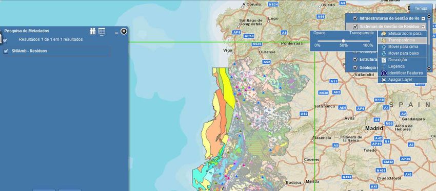
Sistema Nacional de Informação Geográfica - SNIG

     • The Portuguese Spatial Data Infrastructure (SDI) which from its
       geoportal allows to search, visualize and explore geographic
       data about the Portuguese territory, produced by public ou
       private entities.

     • Technological platform for monitoring the activities related to
       the aplication of the INSPIRE - INfrastructure for SPatial
       InfoRmation in Europe, Directive in Portugal.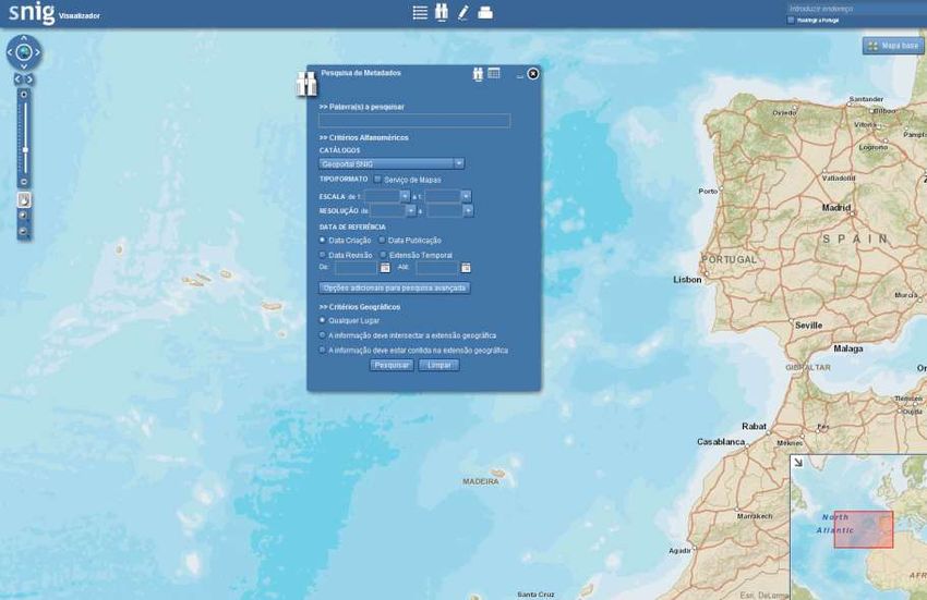
SNIG – The Concept

     • The entities register themselves on SNIG and submit the
       metadata of the spatial data and the metadata of the
       services which they produce. These metadata need to
       respect the National Profile of Metadata.

      • Main objective: To concentrate in one only place the
        registration of all geografic information regularly produced in
        Portugal. The data can also been visualized on the geoportal,
        through spatial data services normalized with the OGC –
        Open GeoSpatial Consortium specifications, if requested by
        the entity.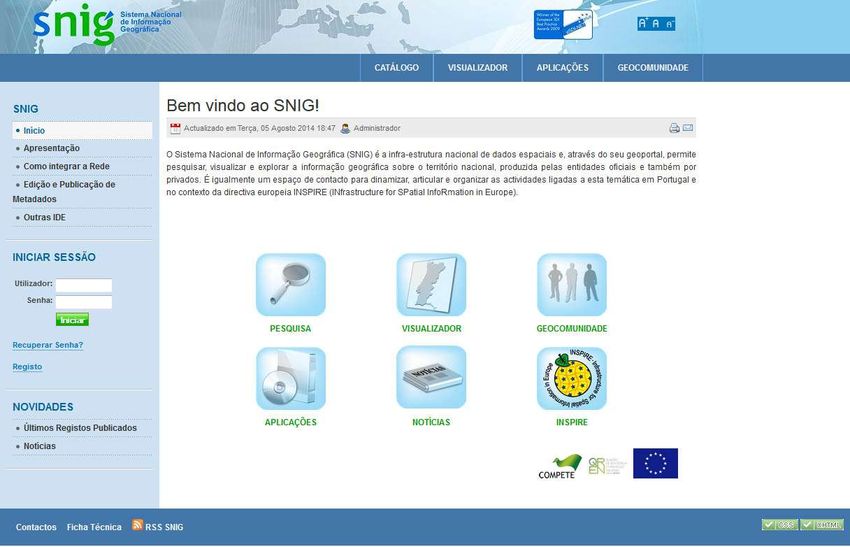
SNIG – Steering Committee

    Article 5, Decret-Law n. 180/2009, August 7

   • “Approve the strategic guidelines and the general objectives of SNIG ”
   • “Ensure to grant public authorities the technical capacity to cross their spatial data
     sets and services on Internet ”
   • “Promote a good articulation between the members of the SNIG network, to
     analyze and to pronounce about possible cases of divergence of interests ”
   • “Approve the work program to enable the establishment and effective operation of
     SNIG, the corresponding financial plans and the participation of each integrated
     service in the costs”
   • “Advise about the national technical standards for geographic information ”
   • “Advise about the rates for data sharing proposed by the public authorities
     involved”
   • “Issue opinions requested under the present law”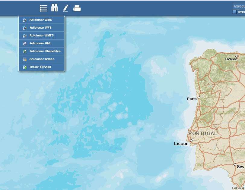
SNIG – Steering Committee
 Actual Configuration:
 • Directorate-General for the Territory     • Institute for the Sea and the
 • Portuguese Environment Agency               Atmosphere
 • National Association of Portuguese        • Directorate-General for Agriculture
   Municipalities                              and Rural Development
 • National Authority for Civil Protection   • Regional Secretariat for Tourism and
                                               Transports of Azores
 • Institute for Nature Conservation and
   Forests                                   • Regional Secretariat for Environment
                                               and Natural Resources of Madeira
 • Army Geographic Institute
 • Hydrographic Institute
 • National Statistics Institute
 • National Laboratory of Energy and
   Geology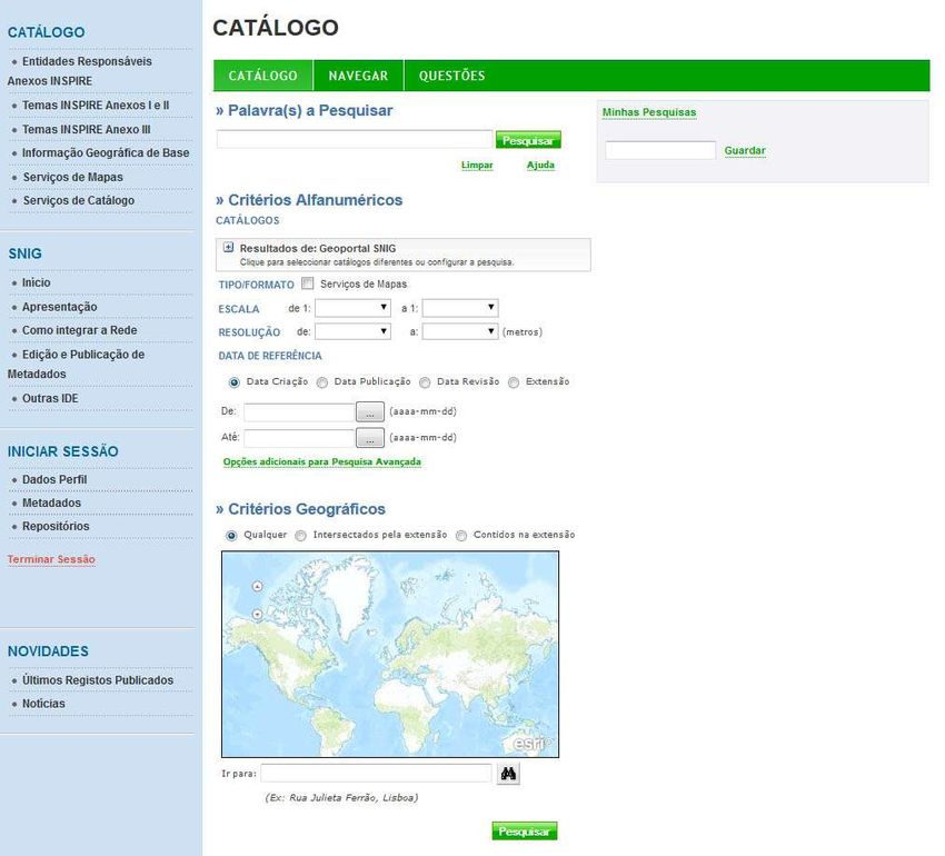
SNIG – Historical Context

     • Landmarks in the evolution of SNIG

                                                                    2006
  1986
                                                               SNIG’s Geoportal
  Working                                                    2004                              2014
 group for                     1995
the creation   1990                            2001 Metadata Editor          2008         Geoportal
                             SNIG on the
  of CNIG Creation of SNIG                 ESDI Initiative              Reformulation     Renovation
                              Internet

               1990                                   2002            2007                2012          2015
          Creation of CNIG                       Creation of IGP INSPIRE Directive       Creation      Develop
                                                                                          of DGT        SNIG
                                                                                  2009
                                                                           INSPIRE Directive
                                                                             Transposition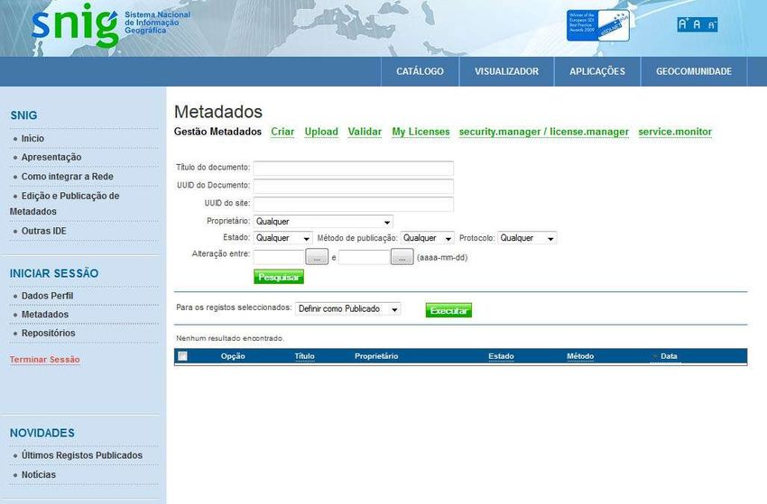
SNIG – INSPIRE Directive
    • Directorate-General for the Territory is the National Focal Point for
      INSPIRE
    • To monitor the implementation of the INSPIRE Directive:
      “... Member States shall monitor the implementation and the use of their
      infrastructures for spatial data and submit reports on the implementation of the
      Directive .”
    • Annual Monitoring :
          Calculation of indicators based on the List of sets and spatial data
          services of each Member State
    • Triennial Reports :
          Organization, coordination and quality assurance of data
          Contributions to the functioning and the coordination of
          infrastructure
          Usage of the Infrastructure for Spatial Information
          Data sharing agreements between public authorities
          Costs and benefits associated with the implementation of the
          Directive and examples of benefits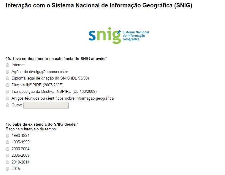
SNIG – INSPIRE Directive
     • Implemented a network called Focal Point Network INSPIRE Core -
       covering public authorities formally responsible for the production of
       spatial data and national services for the themes listed in the three
       annexes of the Directive
                                            Annex III
        Annex I
                                            1.    Statistical units
        1.   Coordinate reference systems
                                            2.    Buildings
        2.   Geographical grid systems
                                            3.    Soil
        3.   Geographical names
                                            4.    Land use
        4.   Administrative units
                                            5.    Human health and safety
        5.   Addresses
                                            6.    Utility and government services
        6.   Cadastral parcels
                                            7.    Enviornment monitoring facilities
        7.   Transport networks
                                            8.    Production and industrial facilities
        8.   Hydrography
                                            9.    Agriculture and aquaculture facilities
        9.   Protected sites
                                            10.   Population distribution and demography
                                            11.   Area management/restriction/regulation zones/
        Annex II                                   reporting units
        1.   Elevation                      12.   Natural risk zones
        2.   Land cover                     13.   Atmospheric conditions
        3.   Orthoimagery                   14.   Meteorological geographical features
        4.   Geology                        15.   Oceanographic geographical features
                                            16.   Sea regions
                                            17.   Bio-geographical regions
                                            18.   Habitats e biotopes
                                            19.   Species distribution
                                            20.   Energy resources
                                            21.   Mineral resources
SNIG - Diretiva INSPIRE
• Entities of the Focal Point Network INSPIRE Core
Administração Central do Sistema de Saúde Instituto da Vinha e do Vinho
Agência Portuguesa do Ambiente Instituto de Financiamento da Agricultura e das
ANA -Aeroportos de Portugal Pescas
Autoridade Nacional de Protecção Civil Instituto de Infra-Estruturas Rodoviárias
Autoridade Tributária e Aduaneira Instituto Geográfico do Exército
Correios de Portugal Instituto Hidrográfico
Direção-Geral de Estatísticas da Educação e Ciência Instituto Nacional da Aviação Civil
Direção-Geral de Recursos Naturais, Segurança e Instituto Nacional de Emergência Médica
Serviços Marítimos Instituto Nacional de Estatística
Direção-Geral do Património Cultural Instituto Nacional de Investigação Agrária e
Direcção Geral de Agricultura e Desenvolvimento Rural Veterinária
Direcção Geral de Energia e Geologia Instituto Português do Mar e da Atmosfera
Direcção Geral de Saúde Laboratório Nacional de Energia e Geologia
Direcção Geral do Território Navegação Aérea de Portugal
Estradas de Portugal Rede Ferroviária Nacional
Gabinete de Estratégia e Planeamento Secretaria Regional do Ambiente e Recursos
Instituto da Conservação da Natureza e das Florestas Naturais da Região Autónoma da Madeira
Instituto da Habitação e da Reabilitação Urbana Secretaria Regional do Turismo e Transportes da
Instituto da Mobilidade e dos Transportes Região Autónoma dos AçoresSNIG – 2014 Renovation
• Technological upgrade of the platform architecture
• Design renovation
• Diversification of the methods for metadata registration
• Configuration and publication of INSPIRE services
• New search functionalities
• Scale
• Resolution
• Producer
• Type of Resource
• ...etc
• New possibilities for visualization and comparison
between added themes on the viewer
• ...etc.SNIG – 2014 Renovation
• http://snig.dgterritorio.pt/portalSNIG – 2014 Renovation • Metadata Submission
SNIG – 2014 Renovation • Search data
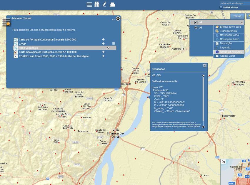
SNIG – 2014 Renovation • Viewer
SNIG – 2014 Renovation • Viewer
SNIG – 2014 Renovation • Adding a WMS Service
SNIG – 2014 Renovation
                         • Adding several WMS Services
Developing SNIG
• This year the Directorate-General for the Territory created a survey
on the internet to understand the level of awareness of SNIG among
the users of geographic dataDeveloping SNIG
• The analysis of the results of the survey and the global
feedback from the different users will help to define a
more adequate and efficient approach to the development
of SNIG
• Until the end of 2015 we plan to complete the diagnosis of
SNIG, which will allow the definition of the next steps in
the development of this SDI and the consolidation of a
strategy for the next years – SNIG 2020.Strategy SNIG 2020
Global principles to consider:
• Strengthen the specific role of SNIG as a SDI with a global
nature and independent from all the thematic, regional and
local SDI
• Mobilize, encourage and support all the entities which
produce geographic information to register those data in
SNIG
• Promote the use of SNIG’s database by all entities which
coordinate the remaining SDIs, through the use of search
services as REST or CSWStrategy SNIG 2020
Global principles to consider:
• Make the access to the data more easy and friendly through the
creation of more OCG services
• Increase the number of platform users through more regular
publicity of SNIG
• Continue to monitor the application of the INSPIRE Directive,
through concerted strategies defined within the Steering
Committee of SNIG
• Build a strategy for the development of SNIG with the
participation of all the data providers and the users of
geographic dataWorkshops, Friday, 29th
Workshops - Programa
Sexta, 29 de maio
Workshop 1 - 09:00 – 10:30
  Infraestruturas de informação Geográfica em Português à volta do Mundo

Workshop 2 - 11:00 – 12:30
  Rumo ao SNIG 2020 e Mentes Criativas

Workshop 3 - 14:00 – 15:30
  Serviços de Dados Geográficos INSPIRE

Workshop 4 - 15:30 – 17:00
  Panorama atual e evolução dos metadados INSPIRE em Portugal
Thank you.
You can also read