Social and economic characteristics of Ladakh, India - Katharine Sherratt Geology for Global Development - The ...
←
→
Page content transcription
If your browser does not render page correctly, please read the page content below
Social and economic characteristics
          of Ladakh, India.

          Katharine Sherratt
     Geology for Global Development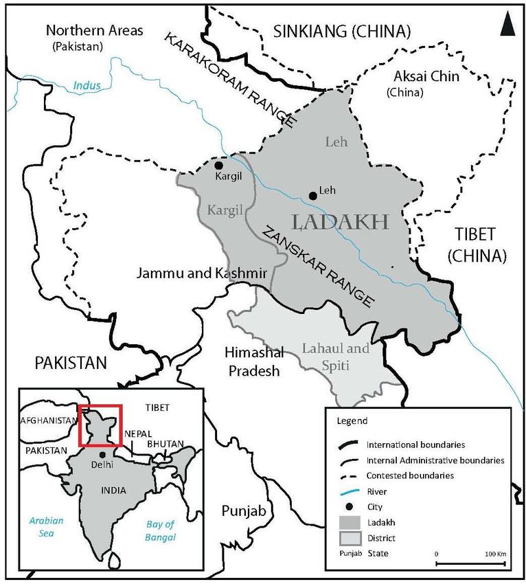
This report was commissioned for charitable purposes, by Geology for Global Development. The
report is intended to provide a useful compilation of literature, media and statistics relating to
culture and demographic characteristics of Ladakh for charities, local authorities or students
working in Ladakh or the surrounding regions. No responsibility can be accepted for any errors,
mistakes or inaccuracies, but we would be happy to correct any errors brought to our attention
in a second edition.
Licencing and attribution
The content on this report is licensed under the Creative Commons Attribution 3.0 licence (CC BY). This means that:
Copyright on any article is retained by the author(s) for the post. The name of a post author is specified in the by-line.
Any third party can use the article freely as long as its original authors and citation details are identified. This
includes a link to the post if used in an online publication, or citing www.gfgd.org for print materials, together with
the author’s name.
Note that this licence applies to the text in this report. While some images are licensed under Creative Commons, others have
been reproduced with permission from the author. Please check the original source for information on how they are licensed
before using them.
To summarise, this licence means anyone is free to Share (to copy, distribute and transmit the work) and to Remix (to adapt
the work), under the following conditions:
Attribution. The original authors and source must be given credit
For any reuse or distribution, it must be made clear to others what the license terms of this work are.
2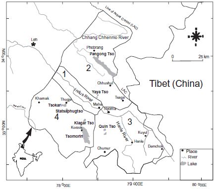
Executive summary

1      Social and economic aspects of Ladakh                                 06

1.1           Introduction
1.2           Agriculture, property and the economy
1.3           Social and economic shifts
1.4           Environmental resources and change

                                                                             09
2      The Changpa tribe

3      Communication                                                         11

3.1           Infrastructure
3.2           Education
3.3           Localised education initiatives

4      The future: adaptive capacity                                         13

4.1           Introduction
4.2           Societal resilience
4.3           Economic resilience
4.4           Institutional planning

5      References                                                            16

Appendix a: Commonly used administrative divisions of Leh district, Ladakh   18

                                                                                  3
Executive Summary
Ladakh has a population density of three people per square kilometer. It has been described as a
“constellation of villages” within the “crossroads of Asia” (Pelliciardi 2010). Despite extreme
topography, and a highly variable cold desert climate, agriculturalists have strategically managed the
environment for perhaps 8,800 years (Miehe et al 2009), but the risks are changing as a result of recent
and rapid climatic and socio-economic shifts. It is possible to adapt to risk, if it the context is
understood and the risks are well communicated.
Since India’s partitioning, there have been continuing border disputes from both Pakistan (since the
1940s) and China (since the 1960s). Ladakh itself, under the state of Jammu & Kashmir, is divided
between the Buddhist majority Leh district, and the Islamic Kargil district.
Historically, subsistence agriculture has been a major component of both society and the economy.
Pastoralists trade dairy, wool, and pashmina goat fibre. Arable farming, of barley and wheat, is tightly
constrained to the summer months, between May and September (LAHDC 2011).
The economy in Leh is expanding. Integration into India, and demand from an Army base, resulted in a
rapid investment in physical infrastructure. Opening to tourism in 1974 created thousands of jobs, and
now contributes up to 50% of the region’s GDP (Pelliciardi 2010). The district population has inreased
by 44% in twenty years (LAHDC 2012), partly due to rural-urban migration. Cash-poor farmers,
traditionally working with a barter-exchange economy, now depend on access to the urban monetary
market.
Population growth has increased pressure on limited environmental resources. While soil erosion
deteriorates in the west, the south and Changthang suffer from groundwater vulnerability and hiking
trail fragmentation (Geneletti & Dawa 2009). Water is a key issue, with reliance on either meltwater or
springs; water shortages downstream can arise due to upstream damming and reservoirs (Le Masson
2013). Although long-term climate change may increase immediate meltwater runoff, water supply may
decrease in the long term (ibid.).
Networks for communicating risk and response are limited. Road access consists of two highways, Leh-
Srinagar and Leh-Manali, both closed annually for 7 months with heavy winter snowfall. Of Leh’s 112
villages, 97 have a connected road, while the average distance to district headquarters is >180km (ibid).
However, in an emergency, the Army base’s communication network is regularly maintained and
updated. Airports (at Leh, and the Army base’s landing strip in Nyoma) provide regional transport
infrastructure. The telephone operator BSNL connects most villages, whereas the other, Airtel, is more
limited. While mobiles are increasingly used, radios are the most widely distributed, with near 100%
coverage (Le Masson 2013).
Literacy rates in Ladakh are higher than the rest of India, but they are unequal for each gender: 89%
male, and 65% female. While most speak Ladakhi with local variants, Hindi, Urdu, and English are
taught from grade I. Despite compulsory education from 6-14, Leh district averages 35% pass at
matriculation (LAHDC 2012). The restrictive national curriculum, and regular teacher rotation (or
absence), fails to motivate locally relevant education (Mellon 2001). However, NGO combined with state
reforms of 2005 have encouraged Ladakh-specific teaching, particularly of environmental constraints
and impacts (SECMOL 2006; Dana 2007).
4Potential short-term risks in Ladakh include landslides, avalanches, earthquakes, drought, and
locus/disease hazards. A rare cloudburst over Leh and nearby villages in August 2010 delivered 14
inches of rain in 2 hours, resulting in flash floods and building collapses which killed over 200 people.
Fatalities in the young and the elderly were disproportionately high, as may be expected (Gupta et al
2012). However, overall fatalities were 62% male, highlighting the interaction of age and gender in
determining vulnerability. This may be explained by the high proportion of males living in the worst
affected area of urban Leh
Community and religious affiliations are a key part of people’s support networks. Relatives of victims
were the primary source of aid after the cloudburst: supporting reconstruction, giving a portion of land,
or helping find new employment (Le Masson 2013). Effective aid was also provided by some
established NGOs, but some cash was misdirected towards constructing unsuitable shelters.
There are concerns that medical capacity could be insufficient for disaster response (Wiley 2002; Gupta
et al 2012; Arsalaan et al 2012). For Leh district, there are 76 doctors (of whom, half are concentrated
in Leh town), 55 nurses, and 40 Tibetan Buddhist Amchi practitioners (LAHDC 2012) . Long-term
pressure on the single equipped district hospital, in Leh is high; when this flooded, nearly all the injured
had to be treated at the military hospital.
Financial risk adaptation occurs on a small scale. Informal insurance schemes can be popular, and the
binding of the agricultural economy with village social structure means protection from loss is usually
available; this may not be the case for rural-urban migrants. Formal financial insurance is limited, given
the very few banking facilities outside of Leh, and high fixed interest rates (J&K Bank 2013); however,
trade is protected by the many agricultural cooperatives (LAHDC 2012).
Under both India and Jammu & Kashmir disaster management, immediate responses to the cloudburst
involved search-and-rescue, shelter, and food and water provision by the Indian forces. The Leh Indian
Army base has the best (and most secure) emergency response facilities in the district. With the main
BSNL telephone exchange destroyed, the Army provided a functioning line of national communication;
as well as using their hospital, army air transport were able to air-lift critically injured to better medical
facilities at Chandigarh.
Leh district’s disaster management plan lays out the range of available facilities, infrastructure and
communications for dealing with hazards (LAHDC DCO 2011). A disaster committee includes input
from all major district departments; each block’s headquarters has a ‘control room’ with a protocol for
directing response to, and raising awareness of, hazards.
Ladakh faces a rising population, land use change, and a changing climate. In the face of this socio-
economic complexity, understanding the vulnerability of different groups will be key to reducing risk in
future disasters.
51. Social and economic aspects of Ladakh
1.1 Introduction
In an area slightly smaller than Portugal, Ladakh has a population density of about 3 people per km 2
(Table 1). Despite extreme topography, and a highly variable cold desert climate, agriculturalists have
strategically managed the environment for perhaps 8,800 years (Miehe et al 2009). This report
presents an overview of the nature, communication, and management of risk in Ladakh.
Ladakh gained geopolitical significance in
Population Gender ratio
the 1940s due to partitioning disputes with
(% of district) (m:f)
Pakistan to the north, and, since the 1960s,
Leh district 133,487 0.89
China to the east (Cons & Sanyal 2013;
Leh block, urban 35,324 (24%) 0.61
Figure 1). However, the infrequent border
area
frictions have little negative impact on
Leh block, rural 22,920 (15.6%) 0.86
Ladakhis. In fact, the permanent Indian
Nyoma block 11,103 (7.6%) 0.93 Army base benefits both the economy and
Table 1: Demography of selected blocks in Leh district infrastructure. On a regional political scale,
Source: LAHDC-Leh 2012 Ladakh comes under the State of Jammu &
Kashmir. Since 1995, Ladakh has had its own Autonomous Hill Development Council, formed in
recognition of its dissimilar regional population and governance issues (this was split in 2003 into
LAHDC-Leh, and LAHDC-Kargil; Appendix a). There is some support for a separate Indian Union
Territory of Ladakh. Pelliciardi (2010) notes that Ladakh is fundamentally a “constellation of villages”,
captured into the Indian nation. The below highlights key aspects of different Ladakhi social and
demographic groups, and their associated vulnerability to regional hazards.
Figure 1: Political map of Ladakh, within India and Jammu & Kashmir state
Adapted from Le Masson 2013
Used with permission
The primary social unit is at the household level, while religion is seen to be equally important (Le
Masson 2013:194). Hindi, Urdu, and English are taught from grade I, while most speak Ladakhi with
6local variants. The Changpa speak a Tibetan dialect of Ladakhi. Leh’s population is majority Buddhist
and historically associated with Tibet, while Kargil (divided from Leh in 1972) is mostly Balti and
Muslim Dards (originating from the northwest). Despite a long history of peace, conflicts between
religious communities are more frequent with increasing population (Smith 2013), particularly in the
denser, more competitive environment of Leh town. Nearly all activity is agricultural, with the
exception of the large number of monasteries, and the major regional trading towns of Leh and Kargil.
This is changing with increasing national and international influences: both becoming geopolitically
integrated into India, and opening to tourism in 1974, have caused significant shifts in social structures.
This report focuses on Leh, as although Kargil is Islamic and slightly wealthier, it shares common
attributes in terms of socio-economic structure with Leh. In addition, this report is commissioned for
project work that will take place in Leh.
1.2 Agriculture, property and the economy
Historically, subsistence agriculture has formed the organising structure of both society and the
economy (see LAHDC-Leh 2011). With scarce water availability (almost no rainfall, and a reliance on
glacial meltwater channels and springs), the villages are scattered between small areas of land in the
river valleys of the Indus, and its tributaries Shayok and Zanskar. Pastoral herding of yak, sheep and
goats suits both nomadic and settled communities, while the latter also cultivate barley, wheat and
peas, and increasingly horticulture (apricots, apples). Seasonal patterns of agricultural production
drive village activity. Pastoralists trade dairy, wool, and most lucratively, pashmina goat fibre to the
Kashmiri region. The arable agricultural schedule is tightly constrained: the growing season is
extremely short (between May and September). Sowing occurs between 15th April – 25th May, and
harvesting between 15th August and September (LAHDC-Leh 2012). As a result, farmers in Ladakh are
extremely risk-averse in adopting untested technology (Angchok & Srivastava 2012).
Property is divided according to agricultural requirements. Villages have traditional and complex
techniques for channelling irrigation; water is allocated by village and household, and if scarce,
mediated by the chhu-pon (Lord of water), an elected village official. The high value and insecurity of
water can make distribution a very politicised issue (Angchok & Singh 2006). Private land property is
very rarely consolidated, as land is usually spread across different altitudes suitable for different times
of the year (grazing sheep & goats at higher altitudes in winter, growing wheat/barley at lower
altitudes nearer the built village during the summer). In winter, private property is converted into
common public land – it cannot be used for agriculture, so livestock are allowed to roam.
Agriculture also determines social movements, as in winter the entire household might move up to the
pastureland if tending a large herd (300+ livestock). School age children, and the elderly, usually remain
in the village year-round (Pelliciardi 2010a). Movement is based on income diversification, since
village-based commercial enterprises are also a factor in the pastureland/village/town migration.
Trading agricultural surplus is usually organised through the localised cooperatives, which ensure both
farmers and consumers receive an affordable price (for example, organising the sale of vegetables to the
Army base; LAHDC-Leh 2011). Goods are also traded between villages, and previously with travellers
across Asia; this is based around a strong bartering exchange economy.
1.3 Social and economic shifts
Major social and economic shifts occurred during Indian integration and border closures. Particularly
the introduction of Indian food rationing, which subsidises basic foodstuffs under the Public
Distribution System, has encouraged a cash economy. In some cases this forced the sale of livestock to
7meet basic needs that were no longer payable in barter goods. This shift in balance between self-
sufficiency and high dependency is much debated (e.g. 40% of food is now imported, but also more
nutritious; see Dame and Nusser 2011).
These changes have further increased the importance of Leh and Kargil towns, as they provide access to
the regional and national market. Leh is the centre of economic activity, and has been growing rapidly
since the Ladakh Autonomous Development Council were granted planning powers in 1995 (LAHDC-
Leh 2011). Integration with the national economy has meant improved access to resources, and
increased investment in physical infrastructure. As well as a ready market, the Army base acts as a
crucial link to national funding. Major change has been driven by opening to tourism in 1974. This has
created thousands of jobs, about £25 million in revenue during 2011, and contributes up to 50% of the
region’s GDP (reviewed in Pelliciardi 2010b). This has also created multiple tensions. Year-to-year
tourist numbers (a majority Indian, with European & American hikers) highly fluctuate; seasonally,
tourism is exclusively in the summer, almost exactly matching the peak of activity in the agricultural
calendar. For the villages, Leh town attracts rural-urban migrants, given employment opportunities in
tourism, as well as civil government and defence (to an extent, this has also altered community social
status rankings to Indian rather than Ladakhi standards; Le Masson 2013).
1.4 Environmental resources & change
The combination of growth in urban functions and a consumer cash economy has increased the stress
on limited environmental resources. This varies with region: soil erosion is high in the west, bordering
Kargil, while groundwater vulnerability and trail fragmentation are problems in the south and
Changthang (Geneletti & Dawa 2009). Water is a particular issue, with reliance on either meltwater or
springs; there have been some reports of water shortages downstream due to upstream damming and
reservoirs. Some water-intensive activity, such as horticulture, requires water to be purchased from
water trucks (Le Masson 2013).
There is uncertainty surrounding the vulnerability of Ladakh to long-term climate change. Changes to
temperature and winter snowfall are fundamental to water availability; this may increase meltwater
runoff, while decreasing water supply in the long term. Annual climatic changes are extreme (reviewed
in Le Masson 2013), with large temperature swings between summer and winter.
82. The Changpa tribe
The Changpa tribe are a social group that Geology for Global Development will be working with during
their project work, and so have a particular focus in this report. Changthang region (Figure 2) falls
between Durbook and Nyoma administrative blocks in the south, bordering Tibet/China to the east.
Within the Nyoma block, the nomadic Changpas move over pastures in the Rhupshu-Kharnak
Rangeland: subsisting and trading produce from large herds of sheep and goats, with yak and horses
used for transport. The extremity of environmental conditions results in high insecurity for the nomadic
lifestyle. However, there are correspondingly complex processes of risk reduction: for example, if the
usual grazing land is unsuitable, e.g. if access is blocked by landslides, groups maintain reserve pastures
(Chaudhuri 2000).
Figure 2: Map of Changthang, Ladakh. (Numbers refer to original publication’s
surveyed areas) Source: Namgail et al 2010
There are three main Changpa communities: Sarnad, Korzok, and Kharnak. These form the permanent
bases, or structures used for storage and winter settlement. However, there are 14 groups of Changpas,
averaging 130 families each. Land is common property, and regulated according to community needs.
Moves are directed by the elected headman (gompa), between allocated pastures. With 6-10 moves per
year, each group has its own system of organisation, building from the core structure of the household
(rebo).
A polyandrous family structure has traditionally been the most efficient for man-power, and the
majority of decision-power lies with the male head of household. While production (herding, milking,
shearing) is divided between men and women, men almost exclusively conduct trade and exchange of
goods. Women have some access to individual means of production in trading handloom and weaving
work (although this adds considerably to their existing burden of labour). Younger, unmarried
members of the household are the most free. With girls having least household influence, it is younger
brothers who catalyse social change, where they are free to migrate to Leh, or chose monogamous
marriage, as they wish.
9Social and economic changes interrelate with the growth of Ladakh and the opening of rangelands to
tourists (Goodall 2004; Namgail et al 2010). Firstly, border wars, with Pakistan and particularly the
1960s war with China, have greatly restricted available pastures. This has also caused some tension and
competition for resources with an influx of similarly nomadic Tibetan refugees. Secondly, the increasing
use of a cash economy has affected the Changpas even more than settled villagers. Lacking cash
resources, and previously reliant on nearby agriculturalists for staples (eg trading wool for grain), there
has been a trend of urban migration to diversify income. The key drivers of migration are seeking
access to children’s education and health in urban areas. To an extent, migration is also driven by
perceived standard of living; Leh and a consumer lifestyle is thought more fashionable and better than
Changpa nomadism (Le Masson 2013). However, with a skill-set limited to nomadic pastoralism,
migration has not often succeeded; the Leh lifestyle can also be unfamiliar and difficult to adapt to
(Chaudhuri 2000).
Formal education was limited or non-existent, until the installation of a purpose built school in Puga in
2005. Children from the the Changpa tribe spend the winter months with their families, living a
nomadic lifestyle, and are delivered to a boarding school to receive an education during the summer.
For many of these children, they are the first in their family to receive formal education.
103. Communication
3.1 Infrastructure
Networks for communicating risk and response are limited; another name for Ladakh is the Hermit
Kingdom (LAHDC-Leh 2011:13). Road access consists of two highways, Leh-Srinagar and Leh-Manali.
These are closed annually for 7 months with heavy winter snowfall. Of Leh’s 112 villages, 97 have a
connected road, while the average distance to district headquarters is >180km (ibid). However, in an
emergency, the Army base’s communication network is regularly maintained and updated, and proved
crucial to the 2010 flooding by providing immediate links to a state and national response (see below).
With the cash economy and foreign imports, motor vehicles are becoming necessary as the quickest and
easiest transport. For example, even in the extremely isolated border area of the Hemla valley, some of
the Changpa population own trucks and cars (Chaurdhuri 2000). Otherwise, transport (in particular for
the nomadic moves of the Changpas) is by yak and horse. Airports are the other regional transport
infrastructure. The airport at Leh is directly connected to Delhi, and the Army base has recently built an
airstrip in Nyoma; helicopters were the main source of emergency transport following the 2010
cloudburst. The construction of a Bilaspur-Manali-Leh railway has begun, but has been significantly
delayed and under-funded (Time of India 2013).
Communications infrastructure includes 56 telegraph and post offices. Telephone and mobile
communications are supported, although not common. The physical infrastructure of the main regional
telephone operator, BSNL, connects most villages; however, this is vulnerable where its main exchange
in Leh was destroyed in the 2010 flood, taking 10 days to repair (Gupta et al 2012). The other operator,
Airtel, is more limited in coverage (not extending as far into rural areas). Mobile phones and signal are
increasingly available, and are more frequently used than landline connections. Radios are the most
widely distributed source of information, with near 100% coverage, while TVs and internet access are
mostly limited to Leh or Kargil towns or wealthier villages (Le Masson 2013).
3.2 Education
Formalising knowledge of specific risks in Ladakh through education has been only recently successful.
Literacy rates in Ladakh are higher than those of India as a whole; averages are 89% male, and 65%
female. However, national education schemes based on a fixed curriculum are poorly implemented, due
to the distinct geography and social groups of Ladakh. Education is free and compulsory from ages 6-14
(grades I-VI as primary, grades VII-X secondary school), with an optional 2 further years at secondary
higher school (XI-XII). The vast majority of schools are governmental (see table 2). They are notoriously
low quality, especially outside of Leh town. Ladakh is perceived as a “punishment posting”, by
government teachers on compulsory regional rotations, and teacher absenteeism can be high (Mellor
2001; SECMOL 2006).
3.3 Localised education initiatives
The influx of tourists and “globalising” influences has incentivised local organisations to promote
traditional Ladakhi cultural education, chiefly driven by the Student Education and Cultural Movement
of Ladakh (SECMOL). In 2005-6, SECMOL initiated “Operation New Hope” for education. Together with
11the LAHDC, they produced very detailed reports outlining the state of educational facilities and
experiences in Ladakh: the classroom environment, textbook material, teacher training and motivation,
etc. They recommended specific regional adaptations of national textbooks to include local, familiar
illustrations, and relevant topics of environmental pollution; they also designed a “Life and Livelihoods”
course for grades 6-8. These working papers are accessible online (see SECMOL 2006). SECMOL also
set up the boarding school campus at Phey, the summer school in Changthang, local Village Education
Committees, and prompted various cultural education schemes (for a review of SECMOL’s
“globalization from below” see Dana 2007). Moreover, there have been various popular environmental
education initiatives focussing on the sustainability of Ladakh. For example, in Leh, the ‘Socially
Engaged Buddhist of Ladakh’ recently (November 2013) hosted a 6 day workshop on “Holistic
Education of our Planet Earth”: this included the frequency and vulnerability of potential damage, soil
erosion, types of pollution, and other environmental issues (for presentations and photographs see
SEBoL 2013). This suggests there is a lack, but growing provision, of communicating environmental
awareness of the risks from land and water pollution.
Matriculation pass %
Government schools
government schools
government schools
Average % female,
Higher secondary
Number enrolled,
Trained teachers
Private schools
Teachers
pass %
1,842
(19% in
primary;
Leh 35 26.4%
351 41 43% middle; 61% 8,641 53%
district (n=661) (n=406)
38% in
higher
schools)
376 1,931
30% 43.5%
Leh block 55 20 (+15 college 70% (45% higher, 55%
(n=128) (n=183)
teachers) 41% middle)
41 58% 736
(42%
Nyoma 141 38.5% 2%
primary, 0 (primary (43% in 55%
block (n=39) (n=25)
51% middle schools: middle
schools) 33%) school)
Table 2. Selected education statistics for 2011-12 in Leh. Source: LAHDC-Leh 2012
124. The future: adaptive capacity
4.1 Introduction
Potential short-term risks include landslides, avalanches, earthquakes, drought, and locusts/disease
hazards. Although adapting to risk primarily occurs at household scale, the 2010 cloudburst pushed
hazard management to be put into an institutional framework.
The August 2010 cloudburst created 14 inches of rain in 2 hours, causing flash floods in the area
surrounding Leh, exacerbated in nearby Choglamsar by dry meltwater river channels. Over 200 people
died, with 800 missing. Fatalities in the young and the elderly were disproportionately high, as may be
expected (Gupta et al 2012). However, overall fatalities were 62% male, highlighting the interaction of
age and gender in determining vulnerability. This may be explained by the high proportion of males
living in the worst affected area of urban Leh. Extensive damage was due to the force of the water,
debris, and building collapse (affecting over 1000 buildings, as adobe mud brick construction is unable
to withstand heavy rain). Key infrastructure was severely impaired: 7 bridges and many roads were
either washed away or blocked by debris, and flooding damaged Leh airport, as well as the district
hospital in Leh, which remained closed for 3 days (Gupta el al 2012). Public works damage is estimated
at 133 crore rupees, or about £44 million (LAHDC-Leh DCO 2011; author’s conversion to purchasing
power parity rate, to GBP, of 2010).
Two sources of aid were crucial in immediate disaster response: intra-community support, and the
institutional mobilisation of Army resources. Household-scale management primarily involves social
support networks, drawn from religious and community ties. Mutual assistance is a strong tradition,
sometimes formalised in a “pashpun”, a grouping of households to organise harvesting and festivals (Le
Masson:192). This was the most crucial source of aid in the aftermath of the 2010 cloudburst. Relatives
gave over portions of land, supported reconstruction, or helped find new employment (ibid.). Overall,
social support from relatives is the strongest form of household and community scale adaptation to
hazards in both the short and long term.
The Army base has the fullest (and most secure) emergency response, communication, and medical
facilities in the district. The cloudburst response involved nationally-linked communications, enabling
the direct involvement of national response teams, heavy-lifting equipment, and crucially the fully-
functioning hospital, which dealt with nearly all casualties as the district hospital was severely flooded.
Army air transport was also able to air-lift critically injured to better medical facilities at Chandigarh.
With the main BSNL telephone line destroyed, the Army provided a functioning line of communication,
which enabled national-scale aid (see below).
4.2 Societal resilience
Health and medical facilities were managed in the short term after the 2010 disaster, although in a long
term context these are much more limited. Medical care involves both biomedicine and traditional
Tibetan Amchi; Leh district has 76 doctors, and 41 Amchi practitioners1. Although there are 138
medical sub-centres, which are intended to be used as the first local point-of-call, many prefer to travel
1It is difficult to know the effectiveness of the Amchi; they are supported as scientifically and
technically sound, in Pordié 2010, but debated, in Wiley 2002.
13to the single district hospital in Leh (Wiley 2002). Despite its overfull capacity and lack of resources,
this tends to be used by citizens over the also publicly open and well-equipped military hospital (ibid.).
The district hospital is the only other centre with facilities such as scanning and operating equipment,
and is acknowledged to be insufficiently prepared for disaster response (Gupta et al 2012; Arsalaan et
al 2012).
Religion provides key community support. Monasteries and faith-based NGOs provided physical shelter
and provisions, and spiritual relief. Ozer (2010) suggests that long-term aid depends on the particular
faith and its version of karma. While the acceptance of fate can motivate a positive response to
unfortunate events, some versions attribute individual blame for bad events and ill health, especially so
for women or psychological issues. Differing Islamic and Buddhist affiliations could potentially create a
divisive community response, although none were found in literature discussing the cloudburst. This is
more likely to be an issue for long-term management of resources, for example where irrigation of land
and clean water supplies are vital and increasingly scarce.
There is a “culture of NGOs” in Leh (Choudhary 2011); 36 were involved in response to the cloudburst.
The most efficient were the long established organisations, including the WWF, Save the Children, the
Red Cross, SECMOL, or the LEDG (Ladakh Ecological Development Group). Some NGOs, however, did
little to help, constructed unsuitable shelters, or used the aftermath for profitable exploitation
(Chaudhary 2011).
4.3 Economic resilience
Long-term financial risk adaptation also occurs at a small scale. Informal insurance schemes can be
popular, and the binding of the agricultural economy with social structure means protection from loss is
usually available. For example (applying to both agriculturalists, and the Changpas), the gompa
regularly collects taxes for community funds (Chaudurhi 2000). Again, however, this is changing with
the growth of the urban/monetary economy. Migrants are forced to either continue paying taxes in the
village, even while they are in Leh, or stop paying and thus cut all ties and social protection. This creates
high vulnerability where migration is unsuccessful.
Formal financial insurance is limited. There are two banks in the region, State National Bank, and J&K
Bank. Although there is a high savings rate, there is little uptake of formalised insurance schemes (J&K
Bank 2013) – perhaps given the very few banking facilities outside of Leh and fixed interest rates of up
to 20%. However, formal banking may be unnecessary with the major role of co-operatives in
protecting trade: some of these schemes maintain considerable working capital (LAHDC-Leh 2012).
Cooperatives are chiefly for agriculture, however, and there are few protecting other income sources
e.g. handcrafts.
4.4 Institutional planning
Institutional planning for disaster response is formulated at national, state and district scales. The
recent Indian Disaster Risk Management Programme has encouraged preparation and planning rather
than emphasising relief. Jammu & Kashmir has a reasonably well-detailed disaster management plan
that deals broadly with the variety of earthquakes, droughts, and fires in the state (DRRR 2011).
National and state responses to the cloudburst involved search-and-rescue and shelter provision by the
Indian forces, as well as air-lifting in food and water supplies, of critical importance with high import
14dependency. After the Leh cloudburst, some reconstruction and funding was badly planned, for
example, pre-fab shelters were mismatched and unsuitable for climatic extremes (Kaur 2011).
More specifically, Leh’s recently formalised (post-2010 cloudburst) disaster management plan lays out
the range of available facilities, infrastructure and communications for dealing with emergency hazards
(LAHDC-Leh DCO 2011). A disaster committee is formed with the input of all major district
departments; each block’s headquarters has a “control room” with a protocol for directing response to,
and raising awareness of, hazards. Examples include identifying citizens who own heavy-lifting
machinery to be mobilised in hazard response, and proposed education programmes to raise public
awareness. The detailed delegation of duties and contact details listed in the plan appears strong and
well planned. It is difficult to gauge how successful this may be upon implementation. For example,
many duties are listed as delegated to NGOs and sub-committees: preparation includes meetings and
drills, but the diversity of organisations involved may not be coordinated in emergency response.
Long-term institutional management is structured by the LAHDC’s 5-year (economic) plans.
Additionally, dealing with a rapidly rising population (more than doubling in 30 years, to 145,000 in
2001), and associated grain and water shortages, the LAHDC-Leh proposed a “2025 Vision Document”
in 2005. This suggested sustainability through increased irrigation and emphasis on regional cultural
practices (e.g. polyandry as a traditional population control).
155. References Angchok D. & Srivastava R., 2012. ‘Technology Intervention and Repercussion among High Altitude Community of Ladakh: A Case Study of Trench Greenhouse’. Indian Research Journal of Extension Education Special Issue, 1(1) pp. 268-271 Angchok, D. & Singh, S. 2006. Traditional irrigation and water distribution system in Ladakh. Indian Journal of Traditional Knowledge, 5(3) pp.397-402 Arsalaan F., Rashid B. & Aggarwal O., 2012, Leh cloudburst and its medico-legal implications. JK- Practitioner, 17(1-3) pp.76-79 Chaudhuri A., 2000. Change in Changthang: To Stay or to Leave?. Economic and Political Weekly, 35(1- 2), pp. 52-58 Chaudhary S., 2011. Working of NGOs in Ladakh. Greater Kashmir. Online, available at: http://www.greaterkashmir.com/news/2011/jan/26/working-of-ngos-in-ladakh-3.asp Cons J. & Sanyal R. 2013, Geographies at the margins: borders in South Asia, an introduction. Political Geography 35(1), pp.5-13 Dame J. & Nüsser M., 2011. Food security in high mountain regions: agricultural production and the impact of food subsidies in Ladakh, Northern India. Food Sec., 3(1), pp.179–194 Dana J, 2007. Globalization from below: How Ladakh is responding to globalization with education. Education, Globalization and Civil Society, Online, available at http://www.macalester.edu/educationreform/publicintellectualessay/new%20pies/Dana%20Ladakh %20and%20Education%20PIE.pdf DRRR (Department of Revenue, Relief and Rehabilitation), 2011. J&K State Disaster Management Policy 2011. Online: Available at http://kashmirdivision.nic.in/Policy_on_Disaster_Management_13022012.pdf Geneletti D. & Dawa D., 2009 Environmental impact assessment of mountain tourism in developing regions: A study in Ladakh, Indian Himalaya. Environmental Impact Assessment Review, 29(1), pp. 229–242 Goodall S., 2004, Changpa nomadic pastoralists: differing responses to change in Ladakh, north-west India. Nomadic Peoples 8(2) pp.191-199 Gupta P., Khanna A. & Majumdar S., 2012. Disaster Management in Flash Floods in Leh (Ladakh): A Case Study. Indian J Community Med, 37(3), pp.185–190. J & K Bank 2013. Our branch network in J&K. Online: available at http://www.jkbank.net/ourBranches.php Kaur R., 2011. How not to manage disaster relief. Online: Available at: http://infochangeindia.org/disasters/related-features/how-not-to-manage-disaster-relief.html 16 | P a g e
LAHDC-Leh (Ladakh Autonomous Hill Development Council – Leh) 2011. District Profile. Online,
available at http://leh.gov.in/pages/leh.pdf

LAHDC-Leh 2012. Statistical Handbook. Online, available at http://leh.gov.in/pages/handbook.pdf

LAHDC-Leh DCO (Deputy Commissioner Office) 2011, Disaster Management, Online, available at
http://www.leh.nic.in/Disester%20Management%20Leh.pdf

Le Masson V., 2013. Exploring Disaster Risk Reduction and Climate Change Adaptation from a gender
perspective: insights from Ladakh, India. Brunel University: PhD Thesis

Mellor B. 2001. Culture Matters: Developing Ladakhi Education on the Margins of India. Edinburgh
Papers In South Asian Studies, 17(1), pp.1-57

Miehe G., Miehe S. Kaiser K., Reudenbach C., Behrendes L., La Duo, Schlütz F., 2009. How old is
pastoralism in Tibet? An ecological approach to the making of a Tibetan landscape, Palaeogeography,
Palaeoclimatology, Palaeoecology 276(1) pp.130–147

Namgail T., van Wieren, S., & Prins, H. 2010.Pashmina production and socio-economic changes in the
Indian Changthang: Implications for natural resource management. Natural Resources Forum 34(1) pp.
222–230

Ozer S.The Understanding of Karma and Etiology in Buddhist Ladakh in Relation to the Theory of Locus
of Control. Ladakh Studies,11/10, pp.6-13

Pelliciardi V. 2010a. Sustainability Perspectives of Development in Leh District (Ladakh, Indian Trans-
Himalaya): an Assessment. CIRPS, University of Rome Sapienza: PhD Thesis.

Pelliciardi V. 2010b. Tourism Traffic Volumes in Leh District: An Overview. Ladakh Studies, 11/10,
pp.14-23

Pordié L., 2010. Buddhism in the Everyday Medical Practice of the Ladakhi Amchi, Indian
Anthropologist, 37(1) pp.93-116

SEBoL, 2013. A 6 day workshop on holistic education of our planet Earth. Online: available at
https://www.facebook.com/pages/Socially-Engaged-Buddhist-of-Ladakh/139049456113918

SECMOL, 2006. Publications. Online: available at: http://www.secmol.org/publications/index.php

Smith, S. H. (2013). “In the past, we ate from one plate”: Memory and the border in Leh, Ladakh. Political
Geography. 35(1) pp.47-59

Valdiya K. 2000. Free access to topographical maps: Coping with natural hazards, assessing
development potential and monitoring environmental changes. Current science, 79(4) pp.479-48

Wiley A., 2002. Increasing use of prenatal care in Ladakh (India): the roles of ecological and cultural
factors. Social Science & Medicine, 55(1) pp.1089–1102

17 | P a g e
Appendix A: Commonly used administrative divisions of Leh district, Ladakh
Source: LAHDC-Leh 2011

 Villages Panchayats / Blocks < Tehsils:                           District Region   State
          groups of villages with individual administration
 112      9 blocks, within 3 tehsils                               Leh      Ladakh Jammu &
          Nyoma block, within the Changthang region, is the main                   Kashmir
          district of the Changpas (see text)
 129      6 blocks, contained within 2 tehsils                     Kargil

18 | P a g e
You can also read