Proposed Tauriko West Boundary Alteration Submissions - Local Government Commission
←
→
Page content transcription
If your browser does not render page correctly, please read the page content below
Proposed Tauriko West Boundary Alteration
Submissions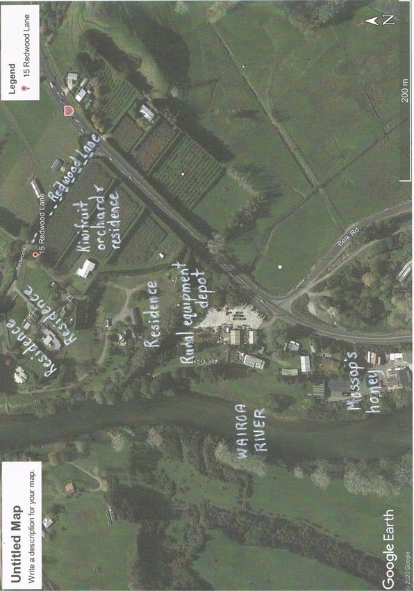
Submission: 1

Name: Richard Luoni

Address: richluoni@gmail.com - Marshall Ave, Greerton

Received: 22 March

Acknowledged: 23 March
___________________________________________________________________________

A quick submission around the proposed boundary change for Tauriko.

Positives

- growth of housing market to keep up with demand (note the demand for housing is on
cheap reasonably well priced housing) big subdivisions don't do that

Negatives

- I live near the Pyes Pa and Greerton round about. The traffic coming over the Kaimais and
from the lakes is already in excess of what the infrastructure can handle. Traffic is
herendous.

- Bethlehem turn off is already at capacity.

- 3000 houses equals 5000 cars extra on a daily basis. What is the plan to deal with this,
when the infrastructure already cannot cope?

- Cameron Road traffic will be affected.

- Pyes Pa Road traffic will be affected.

- Summertime traffic will see it backed up down the Kaimais, how will this be managed?

Risks

- there is a risk to sort out boundaries without sorting out current infrastructure problems.

- If this goes ahead, pressure will come from developers and building companies who are
already desperate for land to be released before addressing the infrastructure issues.

- More traffic means more silly drivers taking risks and being erratic. Which results in more
accidents.
Learn from mistakes.

The Papamoa release has put huge strain on the Bay Fair region and the council are chasing
its tail to rectify the problem.

I am all for development and support the idea, but I believe in a structured approach. I don't
see Tauriko being feasible without upsetting a lot of people and putting a cherry on top of
what already is a bad area that can't cope with its current demand. Don't make a bad
situation worse.

Happy to discuss.
Submission: 2

Name: John O’Neil

Address:

Received: 23 March

Acknowledged: 23 March
___________________________________________________________________________

Given the current transport infrastructure problems the Tauranga area is experiencing with
the existing population the concept of releasing more land for another 3000 houses, 6-7000
vehicles is ludicrous. Asking for submissions for the introduction of light rail systems &
improved roading & bus services that would assist the current congestion problems would
make more sense.

Tauranga was well positioned during the 1990's when the area was starting to grow to make
smart decisions on future efficient transport systems. It was well placed to see how other
towns around the world had successfully or not successfully made provision for growth. One
clear example would be the creation of a light rail system adapting the existing rail corridor,
with the potential to link central Tauranga with Bayfair & the Mount. A circle line could have
been created & incorporated with the harbour bridge widening and branch lines could have
been factored into 5 & 10 year plans servicing Papamoa, Welcome Bay, Greerton,
Bethlehem & Tauriko.

I would support the concept of another 3000 houses at Tauriko West if there was a plan
submitted for transport, schooling, health services & jobs. The transport solution needs to
be something other then just more roads, light rail is an obvious solution, & this needs to be
in place before any houses were built.

The current transport corridors are not working at critical times & this comes at a cost to
productivity & businesses & 'lifestyle' ( the area markets it self as having a great lifestyle).
The area has undergone huge growth in the past 25 years, yet seems to have made the
same mistakes as other growth areas around the world. In 1995 it was perfectly poised to
be a model flagship town with a combination of a great public transport system & roading
network that was being developed ahead of the the anticipated population growth.
Submission: 3

Name: Peter McBride - Trinity Lands Ltd

Address: peterm@trinitylands.co.nz

Received: 26 March

Acknowledged: 26 March
___________________________________________________________________________

I wrote on behalf of Trinity Lands Ltd who own a 4 Ha Kiwifruit Orchard in the identified
zone.

We are supportive of the rezoning as Tauranga has a real shortage of sections available for
building now. This is affecting affordability in our view.

Whilst we are orchardists we do not support the views of Hort NZ or NZKGI in relation to
urban creep into rural zones.

The majority of this land is class 2-3 land in our view and there is very little significant class 1
horticultural land, that’s why this area was identified in the first place.

Thank you for the opportunity to submit.
Submission: 4

Name: Tauranga City Council

Address: campbell.larking@tauranga.govt.nz

Received: 31 March

Acknowledged: 3 April
___________________________________________________________________________

Submission: Proposed Territorial Boundary Change at Tauriko West

On behalf of Tauranga City Council, I am writing in support of the application which the
Local Government Commission received on 1 November 2018, which was proposed by the
Western Bay of Plenty District Council for a change in its boundary with Tauranga City. We
are supportive of the proposal to transfer approximately 189ha of land at Tauriko West
from the district to the city and consider it promotes good local governance that supports
the purpose of the Local Government Act 2002.

As a SmartGrowth Partner and collaborative partner in the Tauriko for Tomorrow Project (to
delivery Tauriko West as an Urban Growth Area), we are strongly supportive of the
application before the Local Government Commission. Tauranga City Council, as a high
growth Council, strong and sustained population growth in recent years and this is
forecasted to continue into the foreseeable future with 56,022 additional residents and
33,307 dwellings by 20531,

Tauriko West plays a critical role for the city and the SmartGrowth partners in meeting the
requirements under the National Policy Statement on Urban Development (NPS-UD). With
the above-mentioned population growth and demand on new dwellings. At present,
Tauranga City Council's land supply falls short of that required under the NPS-UDC in the
medium term (3-10 years) and long-term (10-30 years). This shortfall was forecast as part of
an independent residential review, prepared by Veros Property Services. The shortfall was
reviewed taking into account the latest Statistics New Zealand data. It is predicted that the
city will face a shortage of around 600 new dwellings before mid-2022 if current demand for
new housing continues. The review that looked at available land for housing development in
the next three to ten years and projected the shortfall would increase further until sufficient
new supply becomes established. The capacity shortfall is demonstrated in table 1 below:
1 Tauranga City Population and Household Projection Review 2018 (Growth Allocations
2013-2063)

                                        Dwelling Projection
    As at 30 June 2019              Dwellings Required             Dwelling Shortfall
    Short term (3 years)            3,680                          -600

    Medium Term (4-10 years)        7,967                          -3,500

    Total                           11,647                         -4,100

Table 1 : Tauranga City Council Dwelling Projection

The New Zealand Institute of Economic Research has reviewed these projections and has
considered that the city is at risk of significant housing cost appreciation as a result. It
concluded:

•     Constraint on growth will lead to foregone GDP:
         o $179.8 million over next 3 years.
         o Growing to $524.3 million by year 10
•     House median price:
         o $40,119 per annum in the short term (1 – 3 years)
         o Over the medium term (10 years) increase of $702,082

The pace of development Tauranga and the wider sub region is experiencing, means this
shortfall will only further compound without the release of new urban growth areas. More
development capacity is needed, and Tauriko West is key to meeting these requirements
into the future. The land supply shortfall was highlighted in the findings of the 2016 sub-
regional SmartGrowth Western Corridor Strategic Study Option 3B Settlement Pattern
Review (SPR). This identified shortfall and need for Tauriko West were further confirmed
through the SmartGrowth Future Development Strategy.

As a response, and in order to urbanise the Tauriko West area, the above mentioned
Tauriko for Tomorrow project group was established between the project partners (Tangata
Whenua, NZTA, TCC, Bay of Plenty Regional Council and WBOPDC). This group determined
there were four key inter-related projects in order to urbanise the area. These included:

      •     An amendment to the Bay of Plenty Regional Council Regional Policy Statement
            Urban Limit line to include Tauriko West in the urban growth area - Completed. A
            reorganisation proposal (boundary change), under Schedule 3 of the Local
            Government Act 2002, to amend the local authority boundaries (WBOPDC and TCC)
            to enable the entire urban growth area to be contained within one local authority's
            (i.e. Tauranga City Council) jurisdiction - this proposal;
• An improved Tauriko transport network, which project partners will need to
implement through future transport system improvements. The Tauriko West
Transport Network Connections Detailed Business Case (DBC) is being developed by
the partners which will outline a co-investment and implementation plan for a range
of transport system improvements including a first stage of transport improvements
to enable development of Tauriko West to commence in the short term -planning
underway; and
• Subject to the above, changes must be made to the Tauranga City Plan (TCC) to
rezone the land from rural to residential following structure planning and planned
provision of infrastructure -planning underway.
For Tauranga City, the Tauriko West project will deliver a new greenfield urban growth area
of approximately 3000 dwellings, supported by the existing Tauriko Business Estate and
Tauriko Crossing developments.
The project is crucial in meeting the National Policy Statement development capacity
requirements. It involves significant multi-modal transport, waters, reserves and
social/community infrastructure planning and delivery.
The vision for Tauriko West is to create a thriving community for locals to live, learn, work
and play locally. The proposed development will respect the Wairoa River and preserve the
area's natural character, while building a sustainable community around the currently
underway Tauriko Business Estate and Tauranga Crossing.
In short, the project will become key to the housing supply shortages present within the
Councils growth projections, and also aid in the continued functioning of the local and sub
regional economy.
In summary, Tauranga City Council strongly supports the proposal before the Local
Government Commission to alter the territorial boundary between Western Bay of Plenty
District and Tauranga City at Tauriko West to include 189 hectares within Tauranga City
Council's jurisdiction. It is considered that this proposal is vital in allowing the Tauriko West
Urban Growth area to proceed and we are supportive of the proposal for the following
reasons:
• It will facilitate an efficient use of resources and provide for the seamless future
planning, servicing and governance of the proposed new urban growth area;
• It will promote efficiencies and cost savings in relation to the provision of
infrastructure to the area, as TCC can provide access to its existing waters and
wastewater network without the need for WBOPDC to develop costly infrastructure
to service the growth area;
• Allow for a more productive local government framework with the growth area to
be managed exclusively by one territorial authority, meaning there is no duplication
or confusion between service providers;
• It will provide the ability of the SmartGrowth sub-region to meet the demands of
our growing community to continue to develop and prosper; and
• Effectively responds to the needs of the growing Tauranga City community through
the provision of sorely needed housing supply.If the boundary alteration is to proceed as proposed and an Order in Council be made to alter the territorial boundaries. Tauranga City Council requests that the effective date of change occur on 1 January, 2021 in order to provide an effective transition for rating purposes and also other Council functions. Thank you for considering our submission, and should you have any further queries please contact Gareth Pottinger on email gareth,pottinger@tauranga.gobt.nz or via phone 07-577 7000.
Submission: 5

Name: Tauriko Property Group

Address: matthew.lagerberg@classic-group.co.nz

Received: 6 April

Acknowledged: 6 April
___________________________________________________________________________

We support the proposal in its entirety and submit that this take place as soon as possible.
We note that the application was submitted in November 2018. We are, for all practical
purposes, one of the three major land owners in the affected area. Our support for the
proposed change is for the following reasons:

1) Tauriko West is going to be a comprehensively planned, live-work-play-learn growth area.
It has support of both Tauranga City Council, Western Bay of Plenty District Council, Bay of
Plenty Regional Council (who has amended their Urban Limits Line to accommodate
growth), the Ministry of Education and the New Zealand Transport Agency.

2) The affected area is an agreed growth area that is much needed to support Tauranga
City’s rapid growth and meet the requirements of the National Policy Statement on Urban
Development Capacity (and the proposed National Policy Statement on Urban
Development).

3) By itself, the proposed boundary change will have very little affect, these are mainly
administrative, such as which Council current landowners pay rates to, vote for, and be
serviced by. We consider that these landowners are likely to identify more as ‘Tauranga’
residents than ‘western bay’ residents, regardless of future development aspirations: eg.
They are more likely to visit the library in Greerton (TCC) than one in Katikati or Te Puke
(WBOPDC).

4) We acknowledge that it is hypothetically possible for this growth area to be advanced
without the proposed boundary alteration, but we maintain that this would unnecessarily
complicated. This is mainly because the infrastructure needs to be provided by Tauranga
City Council, and this will be an extension to the existing Tauranga urban area.

5) We submit that the proposed change to bring this land area into the boundaries of
Tauranga City promotes good local government, as follows:
a. It enables democratic local decision-making by and on behalf of communities.
          This is the second round of consultation undertaken by the Local Government
          Commission. The Commission previously notified the application on 15 March
          2019. We also submit that, whilst not specific to the local government boundary
          change, the commission should be recognise that the broader ‘Tauriko West’
          project has provided, and will continue to provide ample opportunity for
          democratic decision making eg. Tauriko for Tomorrow website
          (www.taurikofortomorrow.co.nz), BOPRC Regional Policy Statement Changes and
          the subsequent Tauranga City council Plan Changes that will follow the boundary
          change current being considered.
       b. b. It meets current and future needs for good-quality local infrastructure, public
          services and regulatory functions. The infrastructure, services and functions must
          be efficient effective now and into the future. Transferring the affected land
          area into Tauranga City will allow infrastructure, services and function to be
          provided in a much more efficient manner than if the land were to stay within
          the Western Bay district. Servicing a growth area with necessary infrastructure
          over across a local government jurisdictional boundary, whilst possible, will
          convoluted and inefficient requiring a lot of double handling by authorities.
       c. c. The decision will produce efficiencies and cost savings. It is will also contribute
          productivity improvements for both involved Councils, households and
          businesses. It will lead to simplified planning processes. The planning processes
          to enable urban development at Tauriko West are already somewhat complex
          involving both TCC and WBOPDC, the Regional Council and central government
          (NZTA, MoE). Tauranga City Council is already well advanced in the preparation
          of the required changes to its City Plan to enable this growth and has already
          allocated funding in the 2018-2028 Long Term Plan for infrastructure (roads,
          water, wastewater, stormwater and social) for the future growth of this area.
          Allowing the land to come within this Council will allow for a more simplified
          planning process to be led. The alternative (leaving the land in the Western Bay
          District) will be somewhat convoluted, and not represent good local government.

The proposed boundary change meets all the tests of promoting ‘good local government’
and therefore should be supported by the Local Government Commission. Should a
direction be issued which specifies some form of hearing or public meeting, we do wish to
be heard in support of our submission.
Submission: 6
Name: Bay of Plenty Regional Council
Address: Rebekah.waltham@boprc.govt.nz
Received: 6 April
Acknowledged: 7 April
___________________________________________________________________________
As a SmartGrowth Partner and collaborative partner in the Tauriko for Tomorrow Urban
Growth Project Bay of Plenty Regional Council is aware, and supportive, of the proposal to
alter the boundary at Tauriko West.
Background
The Commission updated SmartGrowth partners in Tauranga on 17 July 2019 on the Tauriko
West boundary alteration application, and discussed the alternative applications received.
At that meeting the Commission asked that the councils advise on their positon on the
alternative applications, and ideally present a consensus view.
At their meeting on 6 August 2019, the Bay of Plenty Regional Council’s Regional Direction
and Delivery Committee discussed the alternative applications and its response to the
Commission. It was resolved that Regional Council:
• Defers to Western Bay of Plenty District Council and Tauranga City Council to advise the
Commission on a preferred boundary location for the alternative applications, and
• Accepts any agreed position reached between those two councils; and
• Notes the alternative applications are not inconsistent with indicative growth areas
already in the Bay of Plenty Regional Policy Statement and SmartGrowth Settlement
Pattern Review.
I understand the Commission received a joint response email from Miriam Taris and Marty
Grenfell on behalf of Western Bay of Plenty District Council and Tauranga City Council on 29
July 2019, regarding the alternative applications. On 15 August 2019, Bay of Plenty Regional
Council wrote to the Commission advising it supports their position regarding the potential
location of the territorial boundary.
On 23 October 2019, the Commission advised of changes to the legislation under which it
operates and the proposed new process; which essentially sees Tauriko West proceed
ahead of Belk Road, Keenan Road, and Tara Road. On 30 October 2019, we replied advising
Regional Council staff have discussed the proposed new process with colleagues at Western
Bay of Plenty District and Tauranga City councils.
We now provide a submission of support for the proposal.Submission: 7 Name: New Zealand Transport Agency Address: Rodney.Albertyn@nzta.govt.nz Received: 7 April Acknowledged: 16 April ___________________________________________________________________________ Thank you for the opportunity to provide feedback on the proposed boundary alteration between Western Bay of Plenty District and Tauranga City. Waka Kotahi New Zealand Transport Agency (Transport Agency) supports the proposed alteration, which would result in 189ha of land in Tauriko West being transferred from the Western Bay of Plenty District to Tauranga City. This submission reflects the Transport Agency's land transport policy role as well as its perspective as the operator of New Zealand's state highway network. This feedback takes into account the Transport Agency's objectives and statutory obligations, as well as its role in supporting integrated land use planning across the country. The Transport Agency is a 'Tauriko for Tomorrow' partner and supports the sub-region's aspirations to supply additional land for housing. To this end, the proposed boundary alteration will facilitate integrated planning and development in Tauriko West by enabling resource management planning to be undertaken in a coordinated and administratively simple way. The alteration will also enable essential local infrastructure to be funded, delivered and administered in the most efficient way possible. Future development in this locality will form an extension to Tauranga's existing urban boundary, and it is logical for this contiguous area to be consistently administered under the jurisdiction of a single council. The Government Policy Statement on Land Transport (GPS) sets priorities for transport investment in New Zealand and seeks to deliver opportunities that support urban development. The proposed boundary alteration aids in this objective by supporting integrated development in Tauriko West. The Transport Agency is progressing a programme of transport network improvements for Tauriko West, with funding for the business case approved late last year. Work is underway to identify future initiatives for a safe multi-modal transport system that increases the attractiveness of public transport and walking, cycling and other active modes, while connecting residential housing to wider Tauranga. Tauranga City Council and the project partners are also investigating a package of short-term improvements to enable housing development to commence in Tauriko West. The Transport Agency appreciates the consultation undertaken thus far and welcomes the opportunity to discuss these matters in more detail. Please contact me directly in the first instance.
Submission: 8

Name: Ministry of Education

Address: Antony.Bodger@education.govt.nz

Received: 17 April

Acknowledged: 17 April
___________________________________________________________________________

The Ministry of Education support the proposed boundary change application, subject to
the following feedback.

Background:

The Ministry of Education (the Ministry) is the Government’s lead advisor on the New
Zealand education system, shaping direction for education agencies and providers and
contributing to the Government’s goals for education. The Ministry has responsibility for all
education property owned by the Crown. This involves managing the existing property
portfolio, upgrading and improving the portfolio, purchasing and constructing new property
to meet increased demand, identifying and disposing of surplus State school sector property
and managing teacher and caretaker housing. The Ministry is therefore a considerable
stakeholder in terms of activities that may impact on educational facilities and assets in
Western Bay of Plenty District and Tauranga City.

The Ministry’s submission on the Proposed Boundary Change is:

 The Ministry understand that the proposed change in the boundary between Western Bay
of Plenty District and Tauranga City at Tauriko West was requested in an application made
to Local Government Commission (‘the Commission’) by the Western Bay of Plenty District
Council in November 2018. The application arose from the work of the SmartGrowth
partnership involving the Western Bay of Plenty subregion’s three local authorities, NZTA
and tāngata whenua. It is understood that the Commission has considered the application
and, on the basis of its investigations to date considers that the change would be an
appropriate one.

The effect of the proposal is that an area of approximately 189ha at Tauriko West that is
currently within the Western Bay of Plenty District will become part of Tauranga City. It is
expected that this land will then become available for residential development and could
eventually accommodate up to 3000 houses and 7000 people. The Ministry are aware that
the Western Bay of Plenty sub-region is facing increasing demand and constrained supply of
residential land to accommodate current and foreseeable population growth. The
subregion’s local authorities have identified the “western corridor” including the land at
Tauriko West as an appropriate location for residential development.
The Ministry supports the proposed boundary change and the aspirations to supply
additional land for residential development in Tauranga City as part of a well-planned
growth strategy. The proposed boundary change will allow the subregion’s councils to move
ahead in implementing their strategy for providing sufficient land for residential
development in the Tauriko West Urban Growth area. The Ministry agree that the land
subject to transfer is strategically well-suited to the residential development of land and the
Ministry supports the planning to facilitate this. The Ministry is therefore supportive of the
proposed boundary change in principle, subject to the following:

Schooling Provision

 Given that the land subject to transfer sits on the boundary of two territorial authorities,
consideration must be given to the provision of both primary and secondary schooling to
facilitate the implementation of the Tauriko West Urban Growth area. The Ministry would
like to emphasise that, if not carefully managed, any increase above what would be
anticipated from this level of future proposed development may have wider implications on
schooling infrastructure needs. Based on current Ministry projections, provision of
additional capacity to cater for this growth within the expanding local school network will
likely be necessary as the area develops.

 The Ministry therefore requests that both Western Bay of Plenty District and Tauranga City
continue to engage with the Ministry to ensure that there is capacity available within the
network, and whether the provision of new schools is required to provide for increased
growth in the area, or whether additional area around the existing schools for education
services should be provided for at the planning stage.

Transport – Walking and Cycling Connections

 The Ministry requests that once development commences in Tauriko West, consideration is
given to the need for safe transport routes and access to and from schools (and any future
schools), including pedestrian and cycling access and infrastructure to support the local
school. Should the boundary change commence, the Ministry requests that Tauranga City
develop the walking and cycling connections to enable a co-ordinated approach in safely
accessing all forms of housing and social infrastructure provided in Tauriko West (and the
wider area) to facilitate a high quality of life.

The Ministry looks forward to working with Western Bay of Plenty District and Tauranga City
on how best to represent the future provision for education in or around the Tauriko West
Urban Growth area and see that provision is made for a transport network that is accessible
and safe for students.
Submission: 9

Name: Tauriko West Ltd

Address: bryce@elementimf.co.nz, sean.grace@boffamiskell.co.nz

Received: 17 April

Acknowledged: 17 April
___________________________________________________________________________

The Local Government Commission has proposed a boundary adjustment that would
result in an area of 189 hectares between SH29 and the Wairoa River (known as “Tauriko
West”) that is currently within the Western Bay of Plenty District becoming part of
Tauranga City. Tauriko West Limited is one of the landowning companies of land located
within the proposed Tauriko West residential development area.

The recent documents released by the Local Government Commission regarding the
proposed boundary alteration have been reviewed, including:
   • The public consultation document titled: “Proposed boundary alteration between
   Western Bay of Plenty District and Tauranga City at Tauriko West” dated March 2020,
   and
   • The report titled: “Possible boundary alterations between Western Bay of Plenty
   District and Tauranga City: Investigation process” dated January 2020.

We agree with and support the findings and recommended process set out by the
Commission in these two documents.

Tauriko West Limited therefore fully support the proposed boundary adjustment that
would result in Tauriko West becoming part of Tauranga City Council’s jurisdiction.
Submission: 10

Name: TBE3 and Taurikura Holdings

Address: bryce@elementimf.co.nz, sean.grace@boffamiskell.co.nz

Received: 17 April

Acknowledged: 17 April
___________________________________________________________________________

Introduction

TBE 3 Ltd and Taurikura Holdings Ltd are landholding companies associated with Element
IMF, who are the developers of the Tauriko Business Estate (TBE).

TBE has been under development for 12 years following a private plan change that was
initiated in 2004. TBE continues to respond to strong demand for well-located industrial
land, with its zoned land holdings likely to be fully developed within the next 12-18 months.
All as-yet undeveloped industrial lots have been pre-sold. Given this, there is a real urgency
to put the necessary planning processes in place to facilitate the expansion of the TBE, in
order to satisfy ongoing and future demand for industrial land in Tauranga City and wider
sub-region.

Submission

TBE 3 Ltd and Taurikura Holdings Ltd support the proposed boundary adjustment that
would result in an area of 189 hectares between SH29 and the Wairoa River (known as
“Tauriko West”) that is currently within the Western Bay of Plenty District becoming part of
Tauranga City.

TBE 3 Ltd and Taurikura Holdings Ltd’s submission is that the proposed Tauriko West
boundary adjustment process should incorporate additional land. This includes
approximately 153 hectares of land on the southern side of Belk Road at Tauriko (known as
“TBE Stage 4”) that is currently within the Western Bay of Plenty District becoming part of
Tauranga City.

Figure 1 illustrates the TBE Stage 4 land that is the subject of this submission.

NOT INCLUDED – MAP SHOWING PROPOSED BELK ROAD BOUNDARY ALTERATION

Figure 1: TBE Stage 4 aerial map; area proposed to be included in boundary adjustment
process1
Background

On 18 April 2019 TBE 3 Ltd and Taurikura Holdings Ltd lodged an “Alternative Boundary
Alteration Proposal” with the Local Government Commission (LGC), which sought the same
relief as sought in this submission. That is, the 18 April 2019 alternative proposal sought that
the TBE Stage 4 land be included together in the Tauriko West boundary alteration process
as set out in the 1 November 2018 document titled: “Application to alter the boundary
between Western Bay of Plenty District Council and Tauranga City Council” (which at that
time had been accepted for consideration by the LGC from the Western Bay of Plenty
District Council).

We understand that subsequent to our 18 April 2019 alternative proposal being submitted,
changes to the Local Government Act have come into effect (as at 21 October 2019). This
has made significant changes to the law governing how local government reorganisation
proposals are dealt with and has led to the LGC effectively adopting a new reorganisation
investigation process for Tauriko West. This is set out in a January 2020 document titled:
“Possible boundary alterations between Western Bay of Plenty District and Tauranga City:
Investigation process” (the “Investigation Process document”).

Notwithstanding this new investigation process, the original 18 April 2019 alternative
proposal still provides highly relevant background context and is attached to this
submission.

Responses to the Investigation Process Document

The Investigation Process document identifies that the current process is concerned with
the desirability of alterations to the boundary between Tauranga City and Western Bay of
Plenty District, in four areas identified through the reorganisation processes undertaken to
date. One of these areas is TBE Stage 4, which is referred to as “Belk Road”.

Paragraphs 11 and 12 on page 3 of the Investigation Process document state that:

       “11. At the point where this “reorganisation investigation process document" is being
       adopted, the Commission arguably has the information it requires to consider the
       adoption of a “reorganisation plan” in relation to the boundary at Tauriko West.

       12. Further work is required, however, in relation to the other three areas, with a
       particular issue in relation to Belk Rd, being the state of supply and demand for
       industrial land in the sub- region.”

The following subsections respond to the issues where the LGC have identified that further
work is required, as referred to in the Investigation Process document.
A. The state of supply and demand for industrial land in the sub-region
Tauranga City Council produced a memorandum dated 21 February 2020 for the LGC,
setting out the state of industrial land supply and demand within Tauranga and the Western
Bay of Plenty. This memorandum, which was peer reviewed by Market Economics, drew the
following conclusion:
“In summary this memo demonstrates that industrial land supply is highly
constrained across Tauranga and the Western Bay. In the Tauriko Business Estate,
while additional stages are currently being developed, these sections have been pre-
sold. Consequently, there are almost no industrial sections available for sale in the
development at present and little prospect of additional sections being released in
the short-term, primarily due to 3rd party landowner complications. As such, the
release of the planned Tauriko Business Estate extension south of Belk Road will be a
key part in meeting industrial land demand over the next 3-5+ years.”
Therefore, there is conclusive information establishing the high demand for industrial land
in the sub-region and low level of industrial land supply in the TBE. As set out in the
memorandum, industrial land supply within other industrial zoned areas of the sub-region is
restricted due to unavailability of infrastructure (and long lead-in times for its
development), tenure-related issues and/or planning constraints.
In addition, these other zoned areas do not have the locational benefit that the TBE exhibits,
namely easy access to the Port of Tauranga and major roading corridors to Auckland and the
Waikato (among one of the key reasons that demand for TBE land is so high).
B. The level of information provided, and consultation undertaken
Paragraphs 10 and 11 on page 4 of the Investigation Process document state that the level
of information provided with the original 18 April 2019 alternative proposal relating to TBE
Stage 4 was “less complete” and the consultation “less advanced” in relation to the original
boundary alteration application by Western Bay of Plenty District Council for Tauriko West.
The 18 April 2019 proposal addresses every matter that was required to be addressed under
Schedule 3 of the Local Government Act that was in enactment at the time, and that whilst
landowner consultation was ongoing at in April 2019 this has been progressed further since.
Of significant importance is that there have been several major planning processes that
have been completed identifying the need for the development of TBE Stage 4. These
processes have required high levels of supporting information and community / stakeholder
engagement to make the necessary decisions. These processes include:
• The SmartGrowth Western Corridor including TBE Stage 4 as “Identified Future
Industrial” land.• The Bay of Plenty Regional Policy Statement (RPS) identifying TBE Stage 4 as being
within the Urban Limit (“Start post 2021”). Stage 4 was included in the Urban Limit
as a result of submissions by the applicant on the review of the RPS.
• The Western Bay of Plenty District Plan including text outlining the intent to
expand the TBE south of Belk Road.2
TBE 3 Ltd and Taurikura Holdings Ltd own eight properties, comprising around 80% of the
TBE Stage 4 area. With respect to consultation with other landowners within the remaining
20% area, Element IMF continue to engage with these people. Planning for wastewater
servicing and the roading connection to State Highway 29 have been progressing in the
ensuing time.
The Public Consultation Document
A succinct public consultation document has been released by the LGC, which includes the
following reasoning for why the proposed boundary alteration for Tauriko West is being
sought:
“The Western Bay of Plenty sub-region is facing increasing demand and constrained
supply of residential land to accommodate current and foreseeable population
growth. The sub-region’s local authorities have identified the “western corridor”
including the land at Tauriko West as an appropriate location for residential
development. ...
While the drivers of change are to do with the supply of land for future residential
development, the boundary change process does not itself determine how and when
this development will occur. This will depend upon a series of later local authority
decisions about the provision of infrastructure and resource management planning.
What the boundary change would do is simply bring the area in question within the
boundaries of the city so that the proposed future development of Tuariko [sic] West
can be planned in an integrated manner by Tauranga City Council.
This is seen as desirable because:
• The land will need to be connected to Tauranga City infrastructure networks as it is
not practicable for Western Bay of Plenty District to develop new infrastructure for
Tauriko West.
• While it is hypothetically possible for there to be arrangements for infrastructure
networks to be provided across council boundaries this would be more difficult to
implement – it is simpler if the land simply becomes part of the city.
• It is expected that future residents in Tauriko West will for all practical purposes be
part of the urban Tauranga community and it makes sense for them to vote and pay
rates as part of the city, and to be subject to the same planning and other local
regulations as the rest of the city.Without exception, these reasons are also applicable to the TBE Stage 4 area (and industrial land supply and development). Including TBE Stage 4 area in the boundary alteration will simplify and streamline the infrastructure and land use planning process, ensuring that decision making is efficient and effective and that critical, regionally significant land supply issues are addressed in a timely manner. Conclusion We appreciate the opportunity to make a submission on the proposed boundary alteration process for Tauriko West, and acknowledge the LGC’s stated intent to release a “statement of intentions” to alter the jurisdictional boundary for TBE Stage 4 “later in 2020” as a separate process to Tauriko West. As set out in this submission however, we see that there is no particular impediment for including TBE Stage 4 in the current boundary alteration process and implore the LGC to consider the urgency of facilitating additional industrial land supply for the sub-region. Should the LGC continue to run Tauriko West as a separate process, we would appreciate advice on how to advance the boundary adjustment for TBE Stage 4 as an immediate priority, and the associated timeframes. Yours sincerely
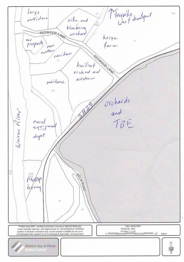
Submission: 11

Name: Keith Catran

Address: keith_catran@email.com

Received: 17 April

Acknowledged: 17 April

My background with this proposal

1. My name is Keith John Catran and I live at 15B Redwood Lane, Tauriko. My property
   borders the Wairoa River at the end of Redwood Lane. My wife and I have lived here for
   some 18 years, having chosen it for the quiet rural lifestyle and river outlook. We have a
   small mandarin orchard on our property. As such I am a key stakeholder in terms of the
   Commission’s consultation process.

2. I have been involved for many years with various proposals for development of the
   residential development area across Redwood Lane from us, now known as Tauriko
   West. I have made submissions to SmartGrowth, and to the local bodies at various
   times, to ensure inappropriate development did not proceed. I took an appeal to the
   Environment Court about an earlier proposed development by a former owner, which
   would have severely compromised the river environment. My concerns were addressed
   by changes made to the District Plan by agreement following mediation.

3. I mention this to show that I have had a strong interest in what happens in this area for
   an extended period. I also made submissions when the original plan change for the
   Tauriko Business Estate (”TBE”) was being considered, particularly about storm water
   discharge into swamp land at the junction of Belk Road and SH29.

4. I have also maintained a strong interest in the consultations undertaken by Transit NZ
   about re-development of SH29, particularly in relation to the junction with Belk Road
   and increasing the highway’s capacity. That remains a real concern because of the un-
   doing of significant planned highway developments following the last election.

Roading concerns

5. The bottom line is that the proposed Tauriko West residential development is unable to
   proceed until SH29 is redeveloped. The highway is carrying very heavy traffic at present,
   particularly in rush hours, with tailbacks often from Barkes Corner (by the WBOPDC
   offices) several miles back to Ruahihi power station. Trying to put residents from
   another 3000 homes onto that roadway would be impossible.
6. In addition, the TBE is now rapidly being developed up to Belk Road, and now proposes
   to cross it and build significant industrial development on the south side of Belk Road.

7. Belk Road exits on to SH29 just metres from a series of sharp corners and hills coming
   off the Omanawa Bridge. The Belk Road intersection is very dangerous to enter and
   leave, and the corners have been the site of an on-going history of accidents. The
   prospect of heavy truck and trailer units exiting the TBE via Belk Road and trying to enter
   the state highway or to enter the TBE from the highway (e.g. coming over the Kaimais
   from Auckland or Waikato) will be disastrous and people will die.

8. Transit had a proposal to re-align the highway to cut out the hills and corners and shift
   the intersection with Belk Road further east along Belk Road, and use fly-overs to allow
   TBE traffic to join and leave the highway safely. It also proposed to four-lane the
   highway all the way through to Barkes Corner, with grade separation at various
   intersections, including Cambridge Road and Tauranga Crossing. I understand all that is
   now off the 10 year plan although it is not possible with the current shutdown to obtain
   any up-dated information from Transit. But it is apparent from an emergency meeting of
   Tauranga City Council this week to seek central government support for major
   infrastructure funding that it is intended that a roundabout be built on the State
   Highway in the vicinity of Redwood lane, to try and accommodate the TBE traffic from
   Belk Road, and presumably some residential traffic coming out of the new housing
   development at Tauriko West.

9. I am concerned that a ‘temporary’ roundabout may be used at the Belk Road
   intersection instead of a proper re-development of the highway. Heavy traffic coming off
   the Kaimais, over the hills and corners and straight into a roundabout would be
   extremely dangerous and impractical. It would also create a huge new roadblock to
   traffic flows, already struggling on capacity grounds. If the roundabout were to be
   shifted a few yards further north, away from the Omanawa hills and corners and closer
   to Redwood Lane, it would exacerbate the alternative danger from heavy vehicles
   coming down the long steep hill from Tauranga. That has, in my time been the cause of
   multiple deaths from a truck and trailer losing control on the hill.

10. The present stage 3B developments to the TBE are clearly directed at using Belk Road as
    a western exit from the business estate. That will be very problematical until the
    highway junction is fixed. But adding a further large additional area to the TBE as
    proposed in one of the alternative applications on behalf of Element IMF parties will
    simply exacerbate the problem. This is not a future problem – the newly developed
    areas of the TBE in stage 3B are being sold and built on at present.

11. I realise that changing the local authority boundary of itself does not involve resolving
    traffic issues, but submit that adequate and safe access when land is sought to be
    included for urban uses should be a relevant issue on which the Commission should be
    satisfied.
Current boundary change proposal for Redwood Lane
12. When the Tauriko West boundary change proposal first surfaced and was heard by the
TA, I made a submission in partial opposition. My requested change was that, instead of
the boundary change extending over Redwood Lane through to the junction of SH29
with the Wairoa River, that the new boundary be down the middle of Redwood Lane.
That would result in my property and my immediate neighbours remaining in Western
Bay, while the proposed urban development properties across the Lane would become
part of Tauranga City.
13. The reasons for my proposal arise out of a desire to remain with Western Bay.
a. The properties on the western side of the lane are all lifestyle blocks involving larger
sites, or rural business uses.
b. All have their own services and are self-contained.
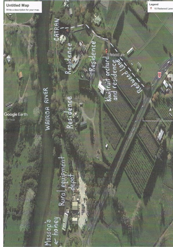
c. Several of the properties have small horticultural or rural uses on them. One is a
kiwifruit orchard, ours has a citrus orchard. One is in a flood plain. Another is a long-
standing and major honey processing plant (Mossops Honey) and another is a depot
for hire of agricultural access equipment, such as cherry pickers and avocado picking
machinery.
d. Many of the residential sites are of a shape that is not susceptible to further
subdivision, being long curving sections created in the latest subdivision to provide
each owner with private access to the river.
e. Accordingly, the inclusion of these sites in Tauranga City would not assist in
improving governance or productivity performance towards adequate supply of land
for urban development within the sub-region. This land is not necessary to Tauriko
West, and highly unlikely to be suitable for urban development.
f. The properties immediately opposite our property on the other side of Redwood
Lane are themselves well-established residential homes with large grounds. It is
highly unlikely that they would be subdivided in the near future given recent
development work undertaken on them. They are a natural buffer between the
proposed intensive development of Tauriko West and the properties on the western
side of the Lane.
g. The inclusion of the western side of Redwood Lane in Tauranga City is not necessary
in any way for the development in due course of the proposed large residential area
on Tauriko West. That development area is a large self-contained rural block, largely
currently farmed. There is no reason to include our land in the boundary change.
h. I have always had good relations with Western Bay staff and elected members. I do
not wish instead to become part of a highly indebted city and be forced to
participate in its problems, politics and infrastructure.14. I made these points to the Council committee hearing objections to the boundary
change. When the decision came out, my submission had been rejected on the advice of
a Council officer that the river formed a “natural boundary’ for the new TA boundary.
15. With all due respect, that assertion is specious. “Natural boundaries” are relevant with
regional authorities ‘because their regions are usually based on river catchments. But for
territorial authorities, no such rationale arises. TA boundaries frequently follow road
lines.
16. In summary, no adequate case has been presented as to why our land should become
part of the city. It is not needed for the Tauriko West development and would not
benefit from the change. The sites and uses are not ”urban” in any way. The stated
reason for including it is nonsense.
17. As a key stakeholder directly affected by the proposal, it is important that my preference
should have considerable weight. This is particularly so when there seems to be no valid
countervailing reason for ignoring or rejecting my preference. I ask that the current
proposal be altered to run the new City boundary down the middle of Redwood Lane, so
as to exclude our property and retain it within Western Bay District Council.
18. I would also ask that my comments on the Highway and Belk Road be considered in
relation to the proposed extension of the TBE south of Belk Road in Element IMF’s
alternative application.
19. Attached are two maps, showing the general area. One is from Western Bay’s MAPI
system and shows the various property shapes and layouts. I have identified our
property (which is by far the smallest, as when we purchased we sold off a large area of
sidling which had been included just to bring it up to minimum lot size, but which was of
no use and a maintenance nightmare.
20. The other maps are two versions of Google map printouts, again with the various
properties identified.
21. I am happy to advise further or explain any aspect as you may require.Submission: 12
Name: George and Shirley Marriot
Address: george@marriott.co.nz
Received: 17 April
Acknowledged: 17 April
We are affected by this boundary change. Our property will become part of Tauranga City.
We are in favour of the boundary change.
However, we have concerns. The following submissions express those concerns and present
some potential solutions.
We hope you will reflect these concerns and some solutions in the recommendations,
guidance and decisions of the Local Government Commission.
We come to you very much as vulnerable smallholders. Our land is just 1 hectare, which
represents 0.53% of the boundary change area. It would be easy for us to be overshadowed
by the large, successful, talented, adept and ambitious developers who are our neighbours
on three sides.
We hope you will do all you can to protect and preserve our wellbeing and our quality of
life through an extensive and invasive development process that is likely to take decades.
We also hope you will take what steps you can to preserve and enhance community value
of our particular part of the expanded Tauranga City.
At the moment, community value here includes:
• our pick-your-own blueberry field, which is quite treasured by many people, families,
playgroups and schools in our community;
• the beautiful towering trees on our property, which give Redwood Lane its name;
• our home’s connection to the name Tauriko. Dating from 1886, the house was once
the site of the local telegraph office, which was named after the nearby Tauranga
Rimu Company. Hence Tau-Ri-Ko. Our house is not actually Tauriko West. It is the
heart and source of Tauriko.
With that context in mind, we will be very grateful to you for considering the following three
concerns and reflecting them in the decisions and documents you produce.Concern 1: Protecting the community value of our blueberry field, the Redwood trees and
the historical connection to the name Tauriko.
For many years, hundreds of families from the local area, New Zealand and around the
world have grabbed buckets and meandered through our blueberry patch to pick their own
fruit.
They happily munch on the berries straight off the bushes, knowing they are grown with
organic practices, without sprays or chemicals. Parents show their children how to use an
honesty box if we’re not around. They sit under our enormous redwood trees, enjoying
picnics, fruit ice creams and time together in nature.
If this Tauriko expansion goes ahead, the developers will have to raise the floor of the river
valley, probably to the level of the houses on Redwood Lane, including our house.
Our blueberry field slopes downward from our house. So our blueberry field will have to
be buried.
Our blueberry field is not just a nice little business. It has community value.
i) We would like you to do what you can to ensure that when the blueberry field is
demolished by the developers, some other enjoyable facility of community value will be
made available immediately. Not in 5 years, 10 years, 20 years, but immediately.
The development aspirations for the area sound good. A nice place to live, work and play.
Our concern, though, is that the “play” part – the core of the community value - will become
a back-burner afterthought that gets neglected while houses are being mass-produced.
ii) We would like you to use your power to ensure there is something in place for families
to enjoy in this part of Tauriko when they can no longer come and pick blueberries.
A community park, for instance, with a walkway down to the river, where we would dearly
love to see a public riverbank path running at the very least to the park at the end of Miles
Line, but hopefully all the way to Bethlehem.
iii With that in mind, we would also like you to do what you can to preserve the beautiful
redwood trees and oak trees on and around our property.
Our house is the old farmhouse for the area and is the original site of the Tauriko name. The
rough 19 century saw-work from the local rimu mill is still visible on our wallboard. But as
th
much as we love it, the house is unlikely to survive development. So …
iv) We would like your support for Tauranga City to include a provision for some kind of
historical marker or plaque, to honour the origin of the name Tauriko.
Perhaps our tallest tree could bear a plaque, describing how the name Tauriko came about.
We hope you will recommend to Tauranga City that they make this kind of community value
a priority as they make plans for this part of Tauriko. Thank you.Concern 2: Safeguarding the interests and wellbeing of smallholders like us. Our neighbours have large holdings. Just a handful of owners cover almost all of the 189 hectares of the proposed boundary change. They will naturally want to optimise the market value of their land. As smallholders, we need to be protected from losing the value of our little pocket of land. If they can, the large land-owners will design the development so that the least valuable land is used for roads, roundabouts, utilities, parks, accessways and non-marketable infrastructure. From their point of view, the least valuable land is land they don’t own, like ours. For many years we have heard that developers are planning to put a road through our house, or a highway roundabout in our front garden. If that has to be, so be it. We don’t want to stand in the way of socially-positive progress. However, it shouldn’t happen just because we only have a smallholding. Please use all your power to ensure that the interests and wellbeing of vulnerable smallholders are protected by provisions that ensure fairness, justice and equitable opportunity. For instance, if smallholder land becomes designated for non-saleable purposes, so that the developers can maximise their stock of sections and houses, the smallholders should be compensated at the residential market rates that will exist when this part of Tauriko is fully developed. That would be fair. That would also motivate developers to use all the land in the optimal way, rather than contouring development to their own holdings. It is asking too much of us vulnerable smallholders that we should have to negotiate our own best deal with the developers. They are experts, we are not. Part of the Tauranga City boundary change should include the recognition that there will be a David-and-Goliath dynamic at work here. We are looking to you to ensure that the interests of smallholders are supported and protected. Thank you. Submission 3: Securing the vulnerable water supply through years of earthworks Water supply is vulnerable in Redwood Lane. There is a lot of bore sharing. We ourselves had a bore down by the river, which no longer functions. We have a long-standing but informal agreement with our neighbour to pay to use their water, which we then also pay to pump to another neighbour. It’s complicated, informal … and fragile. Development of this part of Tauriko is only going to make the water situation even more fragile. Vibrations from years of extensive earthworks could undermine local bores or affect the quality of the water. If we knew there was going to be no development here for the next twenty-five years, it might make sense to put down another bore. No-one can give us that assurance.
You can also read