Urban Governance and Master Plan of Bangalore City - ITPI
←
→
Page content transcription
If your browser does not render page correctly, please read the page content below
Institute of Town Planners, India Journal 7 - 2, 01 - 18, April - June 2010

                                                               Urban Governance and
                                                        Master Plan of Bangalore City

                                           Mahendra B., Harikrishnan K., and Gowda Krishne
             Abstract
             Urban governance with its emphasis on stakeholder participation is often thought to be in
             conflict with the traditional urban planning which is technocratic and top down in its
             approach. For the development of urban areas, both these approaches have to work in
             close harmony and the core principles of urban governance like sustainability, subsidiarity,
             equity, efficiency, transparency, accountability, civic participation, etc. have to be
             incorporated in to the urban planning process. In this context the process of preparing the
             latest master plan for Bangalore city is examined with a view to highlighting the management
             realities and the engagement of stakeholders, conflict resolution process, policy making
             processes and innovative features of town planning which could facilitate urban development.

             1.     INTRODUCTION
             Urban planning as a way for developing urban areas is a recent phenomenon because
             it developed only towards the end of the nineteenth century. With the spread of
             industrial revolution, more and more people started living in urban areas and today
             nearly half the human population live in cities (UNPFA, 2007). To tackle the problems
             brought about by rapid urbanization which began to happen in the beginning of
             last century, urban planning was increasingly adopted as a tool by countries all
             over the world. According to Fainstein (2005) planning developed from a critique
             of the industrial city and also from the desire to re-create cities according to well
             thought out and wholesome design principles with the ultimate aim of creating a
             just city. Urban planners during this period relied heavily on land use planning and
             zoning regulations. Zoning statutes and regulations were very common even in
             free market economies like the United States (Stull, 1974). But from the 1950s to
             the 1970s, urban planning was used by the governments in both developed and
             developing countries to deliver equitable and economically efficient development
             and in this context Master Plans were prepared to regulate city sprawl, ensure
             optimal use of land and efficient provision of infrastructure especially public modes
             of transport (Taylor, 2004). The urban land use planning models developed during
             this period were based on the assumption that the land use planner can collect all
             the relevant data regarding population growth, project the trends in industrial and
             residential location and so on and then rationally devise a land use policy in order
             to achieve predefined social optima (Pennington, 2004). According to Nechyaba
             and Walsh (2004) urban policy makers had to work in the “second best world” in
             which multiple distortions arising from market failures and failure of government
             Mahendra B., Additional Director, BMRDA, Department of Town Planning, Government of
             Karnataka, Bangalore. Email: bychanahallymahendra@gmail.com
             Harikrishnan K., Director, Human Resources, Railway Board, Indian Railways, New Delhi.
             Email: hari_krishnank@yahoo.com
             Gowda Krishne. Professor, Urban and Regional Planning, Institute of Development Studies,
             University of Mysore. Email: krishnegowda@hotmail.com

Mahendra B., Harikrishnan K. and Gowda Krishne                                                     1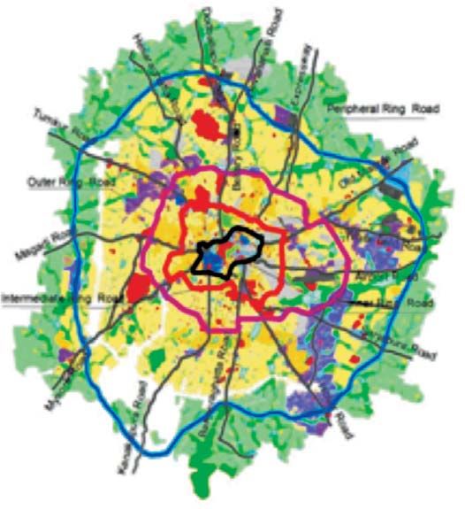
Institute of Town Planners, India Journal 7 - 2, 01 - 18, April - June 2010

policies occurred. Operating in the second best world made urban planning a very
complex exercise. Urban planning was done in a technocratic, top-down manner
using regulatory frameworks to control the use of land and the entire planning
process was often expensive and time-consuming and the carefully prepared plans
were rarely implemented in full and consequently the master plan approach, the
dominant urban planning approach in this era, was considered a failure (Taylor,
2004, Narang and Reutersward, 2006). In India too master planning approach was
commonly followed. According to the Town and Country Planning Organization,
Government of India, Master Plans were prepared for more than 2,000 towns and
cities in India but most of these plans have not been implemented fully and
effectively (Ansari, 2004). Mater Plans were prepared after long delays mainly
because of the lack of proper technological tools like the Geographical Information
System (GIS) and these long delays caused the master plans to be more and more
divergent from the realities and hence the implementation of the master plans
were also adversely impacted. Thus, the master planning approach was not entirely
successful and many consider it as a failure.

2.      TRANSFORMATIONS: URBAN PLANNING AND GOVERNANCE
From 1970s onwards the discourse on urban development focused on the failure of
the state’s command and control approach and a market based approach was
accepted as the reigning paradigm. In keeping with the then prevalent neo liberal
paradigm, urban management and managerialism were increasingly resorted to for
the management of urban areas. New institutional responses like city leadership,
growth coalitions, urban entrepreneurialism, city marketing and market led urban
regeneration; urban service deliveries have emerged during this period (Simpson
and Chapman, 1999). But this new approach also failed to tackle the problems of
urban areas as urban planning still followed the technocratic and top down approach
of the earlier era and hence it lacked the participation and inclusion of all the
stakeholders (Taylor, 2004).

As urban planning fell from grace, throughout the 1980s and the 1990s, the
governments in the west adopted laissez-faire policy and market led approaches.
But because of this policy the cities grew haphazardly, with private interest
increasingly overriding public interest which made cities less sustainable, habitable
and equitable and thus exacerbating the inequity and exclusion (Narang and
Reutersward, 2006). This necessitated a new approach to urban development.

In 1990s, the paradigm was shifting to good governance which emphasized on
participation and inclusion. Governance is defined by the UNDP as the exercise of
political, economic and administrative authority in the management of a country’s
affairs at all levels. Governance comprises of the complex mechanisms and
institutions through which citizens and groups articulate their needs and grievances,
resolve mediate their differences and exercise their rights and get to understand
their obligations. Good governance has many attributes. It is participatory,
transparent and accountable. It is effective in making the best use of resources

     Mahendra B., Harikrishnan K. and Gowda Krishne                                                          2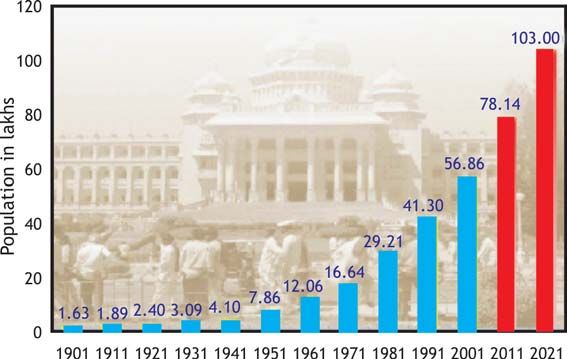
Institute of Town Planners, India Journal 7 - 2, 01 - 18, April - June 2010

                                     Fig. 1 Actors Involved in Good Governance

             Source: http://www.unescap.org/huset/hangzhou/paper/model1.gif

             and is equitable and it promotes rule of law (UNDP, 1997). The three main actors
             involved in good governance are the State, the Civil Society and the Private Sector
             and good governance promotes highest possible constructive interaction among
             the three in order to minimize individual weaknesses and utilize the strengths
             optimally (UNESCAP, 2000). The State provides the foundation of justice, equity
             and peace, creating conducive political and legal environs for human progress.
             The Civil Society rests and functions on the foundation of liberty, equality,
             responsibility and self-expression. The Private Sector provides the foundations of
             economic growth and development (UNESCAP, 2000). These three elements carry
             out the responsibilities by performing multifarious tasks and the major ones are
             listed in the Fig. 1.

             Within the overall governance paradigm, urban governance is defined by the United
             Nations Human Settlements Program (UN-HABITAT) as ‘the sum of the many ways
             individuals and institutions, public and private, plan and manage the common affairs
             of the city. It is a continuing process through which conflicting or diverse interests
             may be accommodated and co-operative action can be taken. It includes formal
             institutions as well as informal arrangements and the social capital of citizens’
             (UN-HABITAT, 2002: 14).

Mahendra B., Harikrishnan K. and Gowda Krishne                                               3
Institute of Town Planners, India Journal 7 - 2, 01 - 18, April - June 2010 When the urban governance paradigm gained prominence, it was often thought that good governance is a substitute for planning, and urban planning may not have any significant role at all in the market-led economic development and if at all urban planning approach was still continued, there is need to ensure that urban planning with its technocratic and top-down approach and urban governance with its emphasis on participation of all stakeholders do not work at cross purposes (Narang and Reutersward, 2006). The new urban governance required not only tools like tax incentives and enforceable contracts for privatizing government functions, but also new processes to carry the tools into effect, including deliberation and dialogue for making policy and dispute resolution like negotiation, mediation, and voluntary monitoring for implementing and enforcing it (Bingham, 2006). In this context, urban planning can emerge as the integrative mechanism for ensuring urban governance by contributing to upstream identification of policy preferences to downstream enforcement (Bingham, 2006). According to Jennings (2004), community participation is now an integral component of ideas like “smart growth” and “New Urbanism” in the field of urban planning. In the meantime, with the increasing focus on urban governance, the UN-HABITAT launched the Global Campaign on Urban Governance in 1999 to support “sustainable human settlements development in an urbanizing world”. The vision of the campaign was to realize the “Inclusive City,” a place where everyone, regardless of wealth, gender, age, race or religion, is enabled to participate productively and positively in the opportunities cities have to offer. Based on its own experience in working with cities, UN-HABITAT initiated a global debate by arguing that good urban governance is characterized by the principles of sustainability, subsidiarity and priority, equity, efficiency, transparency and accountability, civic engagement and citizenship, security, etc; and that these principles are interdependent and mutually reinforcing. Urban planning was also undergoing a paradigm shift during this period. The Third Session of the World Urban Forum held at Vancouver Canada from June 19-23, 2006 focused on “Re-inventing Planning”. It focused on applying new models for sustainable urban development and agreed for a strong emphasis on planning as a tool for urban development and environmental management and also as a means of preventing future slum growth. This view was accepted not just by the government officials and urban planners themselves but also by the civil society groups who wanted planning to be more inclusive, transparent and ethical. The World Urban Forum stressed the important role of planners as agents of change and underlined the importance of sustainability as the backbone of new forms of planning. UN- HABITAT also accepted that urban planning can be a key tool in ensuring good urban governance and for this planning should no longer be about plans and instead it must increasingly be about people (Narang and Reutersward, 2006). In terms of development strategy, planning should be considered as a tool, its effectiveness dependent directly on the quality of the urban governance systems and good Mahendra B., Harikrishnan K. and Gowda Krishne 4
Institute of Town Planners, India Journal 7 - 2, 01 - 18, April - June 2010

             governance and appropriate urban policy should almost automatically lead to good
             planning (Biau, 2004).
             2.1 New Urban Planning
             Urban planning is back in focus now. It is worth noting the phases in the evolution
             of approaches to urban planning at this stage. There have been four broad phases
             in the evolution of approaches to urban planning and management:

             •    Master planning,
             •    Strategic or area planning,
             •    Urban management and
             •    Urban governance (United Nations, 2002).

             The emergence of new paradigms of governance called for reinvention of urban
             planning. New planning practices around the world have incorporated participatory
             approaches as it has come to be recognized that the expert- driven decision making
             processes of the past were quite unsuitable for effective planning. But the elements
             of new urban planning are not yet fully formed (Taylor, 2004). Master planning is
             still practiced with great success in a number of high economic growth countries,
             particularly in Asia, that have strong traditions and cultures of central control and
             the planning process is often accompanied by clear, simple visions and long term
             planning is backed by substantial government investment (Taylor, 2004). It was in
             this context that the World Planners Congress decided to reinvent urban planning
             with a new governance paradigm for managing human settlements and according
             to them “New Urban Planning is a means of setting where and how development
             happens. It is about planning by taking all sections of the stake community alone –
             not only governments, but also private sector organizations, voluntary agencies
             and civil society. New Urban Planning fosters voluntary participation and
             collaboration amongst all these actors. Planning that responds to and works with,
             not manages or directs, the initiatives of non-governmental actors, will produce
             better outcomes. This is a departure from the notion that planning is the impartial
             arbiter of public interest.” (Farmer et al, 2006). In other words, planning has to be
             made operational for public needs and interests. It is thus clear that a new approach
             to urban planning has emerged with the incorporation of the principles of urban
             governance.

             3.      URBAN PLANNING IN THE INDIAN CONTEXT
             Evolution of urban planning in India in recent years was also similar to the
             development in other parts of the world. In the early days of independence the
             accepted paradigm was that India lives in villages and hence urban planning was
             not given much importance and the focus was mainly on the resettlement of the
             refugees from Pakistan and construction of a few new cities as capitals and industrial
             towns. But soon urbanization was progressing at a fast pace and India was expected
             to have the second largest urban system in the world. Urban economy became an
             important driver of economic growth in India and it also acted as the bridge between

Mahendra B., Harikrishnan K. and Gowda Krishne                                               5
Institute of Town Planners, India Journal 7 - 2, 01 - 18, April - June 2010 the domestic economy and the global economy. So in India many States passed legislations to regulate the development of urban areas and used master plans as an important tool for guiding urban development from the sixties onwards. In the eighties the emphasis was on balanced urbanization and the national housing policy was formulated. In the nineties, it was realized that the role of the government was that of a facilitator in urban development and the emphasis was on developing urban infrastructure. The 74th Constitution Amendment enacted during this period was aimed at improving urban governance by empowering urban local bodies by delegating certain functions like urban planning to local bodies. It also aimed at giving voice to the citizens through the District Planning Committees (DPC) and Metropolitan Planning Committees (MPC). The Constitution of India also made it mandatory that not less than two thirds of the members of MPC shall be elected by elected members of the Municipalities and Chairpersons of the Panchayats in the Metropolitan area. In the context of the changing environment and also in the wake of the criticism of the master plan approach in India, the Ministry of Urban Development held a national conference on the theme Alternatives to the Master Plan. This meeting concluded that the only alternative to the master plan is a better master plan. Most planning in urban areas in India now rely on master plans, zoning and land use policies for giving directions for urban growth. Apart from the constitution amendments making planning mandatory, central government attempted to streamline planning in selected urban areas through the Jawaharlal Nehru National Urban Renewal Mission (JNNURM) which was launched on 3 December 2005, for achieving integrated and planned development of cities in a focused manner. This mission provides financial and other support for the urban renewal projects in selected cities but emphasize on the preparation of City Development Plan (CDP) in close association with the peri-urban local bodies including the municipalities, urban panchayats as well as village panchayats within the influence region of the core cities. City Development Plans are required to take into account contents of the statutory master plans also. Ideally when the master plans are prepared after the preparation of the city development plans, they should take into account all the relevant city development plans. At present, the Master Plans prepared under the Town and Country Planning Acts and the City Development Plans envisaged under JNNURM stand on two independent pedestals with no direct relevance to each other. However, the city development plans under JNNURM do not have a statutory backing. The Town Planning Act which authorizes the preparation of master plans does not require extensive consultation with stakeholders and they contain only a provision for publication of plans for public comments. The urban planning is an information intensive activity and the main role of the institutional stakeholders is to supply the relevant information sought by planning authorities but they do not actively participate in the planning process. As such there is no platform for public consultation envisaged in the Town Planning Acts which we argue, is not in line with the spirit of urban governance. But it is possible to prepare a master plan in the spirit of urban governance and ensuring stakeholder participation if innovative Mahendra B., Harikrishnan K. and Gowda Krishne 6
Institute of Town Planners, India Journal 7 - 2, 01 - 18, April - June 2010

                steps are taken in the preparation stage itself by the local planning authorities who
                are authorized under the Town Planning Acts to make master plans. Recently the
                Master Plan for Bangalore city was prepared and published. How public and
                stakeholder consultation was done in the case of Bangalore Master Plan is discussed
                below. We will also examine the incorporation of the various principles of urban
                governance in this master plan.

                4.      MASTER PLAN FOR BANGALORE
                It is in the context of increasing emphasis on urban governance and stakeholder
                participation that the Master Plan-2015 for Bangalore city was published in June
                2007. The Bangalore Development Authority (BDA) is the local planning authority
                entrusted with the task of preparing the Master Plan (MP) for Bangalore city and its
                environs as per the Karnataka Town and Country Planning Act, 1961 (KTCP Act,
                1961). The KTCP Act requires that the MP be revised at least once in every 10
                years. Consequently, the BDA’s mandate was to revise the Revised Master Plan
                (1995), earlier called the Revised Comprehensive Development Plan of 1995. The
                Master Plan – 2015 covers a Local Planning Area of 1307 sq km and consists of 387
                villages, 7 City Municipal Councils (CMCs) and 1 Town Municipal Council (TMC). The
                Master Plan of Bangalore serves as the foundation for developing strategic plans
                and local area plans, and finally, for designing neighborhoods. Objectives of the
                new land use zones and zonal regulations contained in the master plan were to
                safeguard public interest, strengthen and respond to the Bangalore city’s complexity
                by being anticipatory and readily responsive, make realistic regulations, create
                flexible land use zones and above all facilitate implementation.

               Bangalore city, the capital of Karnataka is one of the fastest growing cites in India
               with a population growth of 3.25 percent per annum and it is expected that the
                                                               city’s population will touch 10
                                                               million by 2021. The growth trend
          Fig. 2 Growth Trends in Bangalore City
                                                               in city’s population is shown in the
                                                               Fig. 2. The phenomenal growth of
                                                               the city was spurred by the
                                                               governmental agencies and public
                                                               sector industries to begin with and
                                                               later on it was led by the booming
                                                               IT sector. Bangalore city has a
                                                               salubrious climate, a high quality of
                                                               life, a cosmopolitan ambience and
                                                               social diversity and the city is often
                                                               called “IT Hub of Asia” and also
                                                               “Silicon Valley of India.” Bangalore
                                                               is now competing with other Indian
                                                               cities (like Hyderabad and Chennai)
Source: BDA-2005                                               as well as Asian cities (like Manila

   Mahendra B., Harikrishnan K. and Gowda Krishne                                              7
Institute of Town Planners, India Journal 7 - 2, 01 - 18, April - June 2010
and Kuala Lumpur) to attract and Table 1 Majore Landmarks in the Planned
generate domestic and international Development of Bangalore City
activities and investments and to make 1952 – Bangalore Development Committee founded
the city more competitive, it has to 1961 – Karnataka Town and Country Planning (KTCP)
ensure a high level of “urban Act enacted
efficiency”. The preparation of the 1963 – Outline Development Plan (ODP) submitted to
master plan offered an opportunity to Govt.
do so. For achieving higher efficiency, 1965 – KTCP Act enforced
the master plan should proceed from 1972 – ODB approved and adopted under the KTCP Act
an understanding of the current spatial 1961
issues and infrastructure requirements 1976 – BDA constituted
along with a credible anticipation of 1984 – 1st CDP for 1985 approved
the various social and economic needs 1995 – 2nd CDP for 2005 approved
and requirements of the multi- 2005 – 3rd CDP for 2015 prepared
dimensional Bangalore society.
Source: BDA
Bangalore city has a planning history
spanning more than fifty years. The first step towards planning for development of
Bangalore city was initiated with the Outline Development Plan prepared by the
Bangalore Development Committee in 1952. The city’s planning got statutory backing
in 1961 when KTCP Act, 1961 was enacted. The history of planned development in
Bangalore is highlighted in Table 1. The Bangalore Development Authority (BDA) is
entrusted with the task of preparing a Comprehensive Development Plan (CDP) as
per the KTCP Act.
4.1 Master Plan Preparation
Revision of the master plan for the city of Bangalore began in the year 2003 in
partnership with the community through consultation and participation. After
Table 2. Time Line for Preparation of the Revised Master Plan
• June 2003 - The master plan exercise commenced
• June – December 2003 Land use surveys
• December 2003 – June 2005 Consultation process with key stake holders
• January 2004 – June 2005 Master Plan preparation - Vision Formulation -
Zoning strategy - Zoning Regulations formulation
- Land use Regulations formulation
• June 2005 Draft Master Plan released to public
• November 2005 Advisory Committee to consider the responses
from the public
• December 2005 Announcement of JNNURM
• March 2006 Commencement of CDP exercise under JNNURM
• April 2006- June 2006 Consultations for preparation of CDP
• June 2006- December 2006 Preparation of CDP
Source: BDA (2007)
Mahendra B., Harikrishnan K. and Gowda Krishne 8Institute of Town Planners, India Journal 7 - 2, 01 - 18, April - June 2010
Fig.3 Approach for Urban Development
extensive consultations, the revised master plan was published in June 2007. The
brief time line for the preparation of master plan can be seen in the Table 2.
The master plan aimed at compact, balanced and equitable and even urban growth
for Bangalore city. The directive principles followed in the master plan were to
ensure economic efficiency and social equity and to promote and protect the natural
endowments and historical heritage of the
Fig. 4 Bangalore: Road Connectivity city. The conceptual plan followed by the
BDA in preparing the master plan can be
seen in the Fig.3 and the road
connectivity of Bangalore city can be seen
in the Fig. 4.
For successful preparation of a master
plan, updated information about the
city’s land use and other features was very
essential and for this the BDA obtained
technical support in GIS platform from a
consultancy firm under the Indo-French
Protocol. This was the first time such
technical inputs were used for preparing
the Master Plan for Bangalore. The unique
feature of this exercise was that a Geo-
Referenced Comprehensive Land
Information System was built in for the
entire planning area. Information like land
use, population, etc; down to the parcel
level (individual survey number) was
incorporated into the information system.
Mahendra B., Harikrishnan K. and Gowda Krishne 9Institute of Town Planners, India Journal 7 - 2, 01 - 18, April - June 2010
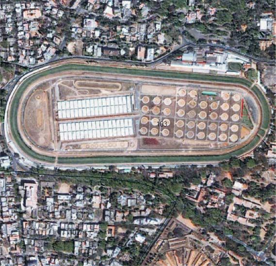
Modern tools like aerial photography Fig. 5 Sample Satellite Imagery
were used to map all the ground details
to prepare the scientific base map.
Quick Bird Satellite images were used
for incorporating the latest changes so
that planning was based on the latest
updated information. In order to
further fine tune the information base,
satellite images were used for feature
extraction which was also validated by
ground truth verification. A sample
satellite imagery used in planning can
be seen in the Fig. 5.
Bangalore city had a comprehensive
city indicator program called the BCIP
which was intended to provide people
with access to the city managers and
to involve them in all stages of policy
cycle, to promote transparency in
procedures and to provide people with
access to information. BCIP provided
an analytical framework and strategy to integrate the various indicators with city
planning, monitoring, development and management activities and helped to
prepare indicators-based planning models which were used in the preparation of
the master plan for Bangalore. The timeline for the preparation of the master plan
is included in the Table 2.
4.2 Stakeholders’ Analysis
The master plan preparation has to be done with active and meaningful participation
of all stakeholders and hence it is necessary to identify them. Citizens are the
most important stakeholders. The master plan exercise is primarily to increase
their welfare. But citizens are a very disparate group with limited interest, ability
and opportunities for participation and Civil societies, Community Based
Organizations (CBO’s), Non-Governmental Organizations (NGO’s) are the channels
through which the citizens voice can be channelized and hence they play an active
and important role in the participatory approach to planning. BDA is also a key
stakeholder as it is the agency which prepares the master plan and has a major role
in its implementation. Bangalore Metropolitan Regional Development Authority
(BMRDA) is the statutory body entrusted with the preparation of structure plan for
the Bangalore Metropolitan Region and the master plan for Bangalore has to be
prepared within the framework of the structure plan. Bruhut Bangalore Mahanagara
Palike (BBMP) is one of the biggest stakeholders as it is responsible for the
implementation of a major part of the MP and is also responsible for formulation of
Mahendra B., Harikrishnan K. and Gowda Krishne 10Institute of Town Planners, India Journal 7 - 2, 01 - 18, April - June 2010
CDP under JNNURM. Bangalore Electricity Supply Company (BESCOM), Bangalore
Metropolitan Land Transport Authority (BMLTA), Bangalore Metropolitan Transport
Corporation(BMTC), Bangalore Water Supply and Sewage Board (BWWSSB), Central
Public Health and Environmental Engineering Organization (CPHEEO), Karnataka
Power Transmission Corporation Limited (KTCPL),Karnataka State Road Transport
Corporation(KSRTC), Bangalore Metro, South Western Railway, Bharat Sanchar Nigam
Limited(BSNL) are also key stakeholders who provide the necessary infrastructure
and utilities in Bangalore. Karnataka Housing Board (KHB), Karnataka Slum Clearance
Board (KSCB) and Karnataka State Pollution Control Board (KSPCB) are the
government agencies involved in various aspects of urban management in the city
of Bangalore. A number of private bodies are involved in the various aspects of the
urban development of Bangalore city especially in the infrastructure and housing
sectors and they play a vital role in the economic growth of the city. The vibrant
private sector also forms an important stakeholder in the city’s development.
4.3 Stakeholder Participation
Ensuring stakeholder participation is an important aspect of urban governance.
The stakeholders mentioned above have all participated in the master plan
preparation at various stages. In the early stages of the master plan exercise itself
consultations were made with the stakeholders and it was agreed upon by all of
them that the long-term strategic vision for Bangalore city is to become a truly
international city and the master plan was meant to be a major tool for achieving
this vision. The draft master plan was prepared by the BDA in consultation with the
various stake holders including the infrastructure and utility providers for
incorporating their requirements and was sent for approval of the state government.
After getting the state government’s approval, the draft master plan was made
available to the public seeking their views and objections. When the draft master
plan was published in June 2005, wide publicity was given and copies of the plan
were made available on all important places in addition to being sold to the interested
parties. The BDA widely advertised: “We are eagerly looking forward to your reaction
with a view to ensure maximum participation of the stakeholders”. This was an
earnest attempt by the BDA to take into account the views of the citizens and
other stakeholders. The BDA conducted an exhibition “The Bangalore Master Plan
2015 exhibition” at an important Auditorium Hall, the “YAVANIKA,” in the heart of
the city from 27th June to 26th August 2005 between 10 AM to 5 PM on all working
days. Presentations were made on all days to facilitate understanding of the
proposals by the key stakeholders. This attracted widespread attention of the
citizens and other interest groups which resulted in about 6,600 suggestions from
the public. Civil Society organizations like Janagraha (NGO) helped in formulating
the voices of the citizens and submitted their responses to the draft master plan.
Though most of the suggestions were related to individual issues, there were also
many important policy suggestions of a general nature from the public. One of
them was regarding the all round development of the city because it was felt that
in the draft master plan the western and southern parts of the city were not given
sufficient attention. This observation was taken in the right spirit by the planning
Mahendra B., Harikrishnan K. and Gowda Krishne 11Institute of Town Planners, India Journal 7 - 2, 01 - 18, April - June 2010 authority and suitable measures were incorporated in the revised master plan. For example an area of about 1000 acres was set apart in the revised master plan as the hi tech zone in the western part of the city keeping in view the work home concept and thereby seeking to reduce movement from western parts of the city to the eastern parts for employment purposes. Another important policy suggestion was regarding allowing some ancillary uses in the basements of buildings in view of the need for efficient use of the scarce land resources and accordingly certain uses like gymnasium, home theatre etc have been permitted in the revised master plan. An advisory committee was constituted by the state government under the chairmanship of a civil servant to look into the suggestions received from the public in response to the publication of the draft master plan. The MP was finalized by BDA after taking into consideration the recommendations of the advisory committee. We can conclude that the BDA’s efforts to ensure participation of all the stakeholders in the preparation of the master plan were largely successful and this was keeping in line with the spirit of participatory urban governance. 4.4 Incorporation of the Principle of Sustainability Sustainability is an important part of urban governance paradigm. It means that cities must balance the social, economic and environmental needs of the present and the future generations. Keeping in view this ideal the master plan of Bangalore has made provisions for incentivizing environment friendly activities like rain water harvesting, solar heating and lighting and tree planting. The master plan attempts to conserve water, power and other resources also addresses the issue of global warming. Provision of rain water harvesting has been made mandatory for all plots which are more than 240 square meters in extent. To incentivize compliance with these provisions, a rebate of five percent on the property tax is offered for residential properties and a rebate of two percent for non residential buildings for the first 5 years, if rain water harvesting is made as an integral part of the building constructed. In the MP, solar lighting and solar water heating is recommended for all new development/constructions. If the solar lighting and solar water heating is adopted, then refundable security deposit on fulfilling the conditions will be returned along with two percent interest. This is also a sound measure to incentivize compliance with the provisions of the master plan. As per the MP, planting of minimum one tree is mandatory for a site measuring more than 2400 sq ft and minimum of two trees are required to be planted for a site measuring more than 4000 sq ft. The concerned authorities have been empowered to ensure that the trees are planted before the approval of building plan is granted and the property tax will be assessed by the authorities only after confirming the existence of trees. The trees are required to be planted only in the rear set back area. The master plan lays special emphasis on the protection and upgradation of the numerous lakes in Bangalore city and tries to promote recreational activities. The MP provides for Protected Land Zone which includes lakes, valleys, tanks and national parks and forests to preserve natural areas and also introduced a Heritage Zone to Mahendra B., Harikrishnan K. and Gowda Krishne 12
Institute of Town Planners, India Journal 7 - 2, 01 - 18, April - June 2010

             protect and conserve natural heritage. The plan gives special emphasis on increased
             green cover and preservation of historical and cultural heritage by earmarking
             areas for green ares, protected land, restricted development land and agricultural
             land zones.

             The slum population of Bangalore is about 10 percent, but the employment
             opportunities and incomes are growing because of the booming economy. The
             master plan gives special focus on poverty alleviation by planning for the networking
             of the five hundred odd slums, creating a database, ensuring tenure security,
             knowledge sharing and capacity building through livelihood development centres
             in collaboration with the KSCB. The MP also attempts to integrate urban poverty
             reduction strategies under the JNNURM into local development planning. The MP
             tries to ensure financial viability by promoting economic activity through the
             participation of all the citizens in the economic life of the city.

             5.     SUBSIDIARITY AND THE MASTER PLAN
             Subsidiarity too is an important aspect of the urban governance. Responsibility for
             service provision is proposed to be allocated on the basis of the principle of
             subsidiarity, that is, at the closest appropriate level consistent with efficient and
             cost-effective delivery of services. Subsidiarity is a device for geographical
             decentralization of urban services. This is expected to maximize the potential for
             inclusion of the citizenry in the process of urban governance. In this context the
             master plan has reduced the cases where approvals and no objection certificates
             are to be given and also promotes decentralized cooperation especially at the
             grass root levels. For ensuring compliance of the safety norms with regard to fires
             and earthquakes, the new master plan authorizes the supervising architects and
             engineers to certify compliance by way of filing an affidavit and this step is expected
             to reduce the bottlenecks and improve subsidiarity. The resident’s associations
             have also been empowered under the master plan for developing and maintaining
             parks and open spaces, which was hitherto done only by the municipal or other
             government agencies.

             5.1 Equity
             Equity of access to decision making processes and the basic necessities of urban
             life is one of the important criteria of urban governance. The principle of equity
             necessitates sharing of power which in turn leads to equity in the access to and use
             of resources. Though gender budgeting or gender disaggregated data have not
             been particularly collected in the preparation of the master plan, no bias against
             any group including women has been shown in the master plan preparation. The
             master plan proposes provision of night shelters for the homeless women and other
             disadvantaged sections of society. The plan also gives importance to the support of
             informal sector by allowing a higher degree of mixed land use. The master plan
             adopts equitable principles for prioritizing infrastructure development and pricing
             urban services to the weaker sections of citizens including provision of housing for

Mahendra B., Harikrishnan K. and Gowda Krishne                                               13
Institute of Town Planners, India Journal 7 - 2, 01 - 18, April - June 2010
the economically weaker sections of society. The MP also tries to create a fair,
credible and definite regulatory framework with regard to the zoning and land use
regulations and this step is bound to increase equity in the development of Bangalore
city. The master plan has also incorporated principles contained in the national
policy on urban street vendors and made provisions for their requirements with a
view to enhance equity in the development of Bangalore city.
5.2 Efficiency
Efficiency in the delivery of public services and promotion of local economic
development is one of the most important aims of urban governance. The master
plan seeks to facilitate financially sound and cost-effective management,
administration and delivery of services. In the provisioning of these services, based
on comparative advantage, the master plan envisions the government, the private
sector and the communities to contribute formally and informally.
The master plan particularly facilitates delivery and regulation of public services
through partnerships with the private and civil society groups. It adopts equitable
user-to-pay principles for various services and approvals. The master plan also has
innovative means of delivering public goods and services through management
contracts and public private partnerships to promote integrated, inter-sectoral
planning and management of the city’s development. The plan gives special emphasis
on a fair and definite legal and regulatory framework that encourages commerce
and investment, minimizes transaction costs, and legitimizes the contributions of
the informal sector and also adopts enabling provisions for the delivery of public
services with a view to maximize the contributions of all sectors of society to
urban economic development and also attempts to encourage voluntarism in the
development of Bangalore city.
Bangalore city is having severe shortage of parking space and parking problems are
acute and increasing especially in the developed areas of the city. The master plan
proposes to increase the parking facility through private sector participation by
permitting multilevel car parking as an independent use without any restriction on
the floor area ratio (FAR). In case, additional car parking is provided as part of a
parking complex or parking lot in excess of required car parking, such area is also
exempt from the calculation of FAR and this step is expected to augment the
commercial supply of parking facilities as there would arise attractive incentives
for parking service providers. A large number of high density developments like
kalyanamantapams (community hall), multiplexes, star hotels, etc; are coming up
in Bangalore city without any restrictions on the minimum plot area on which they
are located or the minimum road width they had access to because the earlier
master plan did not specify these requirements and this created inefficiencies and
traffic congestions near incorporated. In the revised master plan, specifications
have been prescribed in terms of the plot area and minimum road width for large
uses like kalayanmantapams, multiplexes, etc; keeping in view the traffic that
would be attracted and generated by them.
Mahendra B., Harikrishnan K. and Gowda Krishne 14Institute of Town Planners, India Journal 7 - 2, 01 - 18, April - June 2010
In the revised master plan, the provision of setbacks has been rationalized by
specifying it in many cases especially for smaller plots, as a proportion of the width
and depth of the plot respectively in place of the unscientific slab system used
earlier. The earlier system was susceptible to noncompliance as the specifications
were not rational because even a marginal increase in plot size could lead to
substantial increase in the requirement of set backs, if the plot size was near the
slabs prescribed. But the master plan has removed this anomaly by removing the
slab system and hence it incentivizes better compliance and more efficient use of
the resources. A comparison of the earlier slab system and the revised percentage
system can be seen in the Table 3.
Table 3 Setbacks for Building Height up to 11.5 m and
Plot Size of up to 4000 sq. m
Width of site Depth of site
Width / Depth of site (m) Right side Left side Front side Rear side
Up to 6.0 1.0 m 0 1.0 m 0
Above 6.0 up to 9.0 1.0 m on all sides
Above 9.0 m 8% 8% 12% 8%
Source: BDA (2007)
Table 4 Comparison of RCDP - 1995 and RMP -2015
Earlier Master Plan - 1995 RCDP Current Master Plan - RMP 2015
For a 30x40 plot - Front setback is – 4’11’’ 12% of depth- ie the set back is –4’9’’
For 30x42 plot - Front setback – 9’10’’ 12% of depth- ie the set back is –5’0’’
Note: For example for 30’0" x 42’0" plot the front set back as per the earlier slab system
was 9’10’’ whereas the front set back as per the new master plan is only 5’0” and
hence there is more economic and efficient use of land.
The core areas and other old areas of the city have become highly overcrowded
due to over concentration of activities, traffic congestion, inadequate parking
space, insufficient infrastructure, etc. The traditional approach was for the
government or the civic bodies to acquire land and invest huge funds in
redevelopment of these areas. But this approach was not successful because of the
legal and other complications in land acquisition, inadequate availability of funding,
etc. A need was felt to bring the redevelopment of these areas out of the exclusive
realm of the government and civic bodies and to encourage private participation.
The MP has adopted many innovative steps in this direction. In order to incentivize
private participation in redevelopment in old and core areas, more FAR is permissible
for redevelopment activities in such areas. As an additional method of incentivizing
redevelopment, additional FAR (0.25-0.5 depending on the size of the plot) is also
permissible in these areas if the plots are amalgamated and reconstituted especially
if the small sized plots are consolidated. The MP also introduced the new concept
of transfer of developmental rights. When an area within the local planning area is
required for a public purpose (road, widening of road, parks, etc.) the owner of
Mahendra B., Harikrishnan K. and Gowda Krishne 15Institute of Town Planners, India Journal 7 - 2, 01 - 18, April - June 2010 the land can surrender it free of cost to the public authority and the planning authority will permit development rights in the form of additional floor area equal to one and half times the area so surrendered. The development rights so permitted may be utilized either at the remaining portion of the plot after surrender or any where in the local planning area, either by himself or by transfer to any other person. The developmental rights can even be traded and this is an attempt to use the market efficiency for facilitating redevelopment. The trading or transfer of development rights is an innovative feature of this master plan and is proposed to be used as a tool not only in redevelopment but in other areas also. These innovative steps are expected to lead to more efficient use of the land resources. With a view to encourage redevelopment schemes taken up by KSCB/BDA/BBMP/KHB, such schemes are allowed in all the land uses except in the case of parks and open spaces and also public and semipublic uses. Incentives have been given for such schemes by way of increased plot coverage and by allowing more FAR also. Provision of utilities like bus bays, electrical substations, etc; are often done in an inefficient manner because of the lack of adequate provision of earmarked space for them. In order to alleviate such problems the master plan makes it mandatory for large scale developments to earmark specific areas for such utilities. With a view to give impetus to economic growth and to retain the vibrancy and dynamism of the urban form for a city like Bangalore, the master plan introduced the concept of ‘Integrated Township’ with minimum forty hectares of land having access from a road of minimum 18 meters width. For ensuring efficient development of the city it is necessary that the developments are undertaken as per the provisions of the master plan. Although there are penal provisions to ensure compliance, the present master plan adopted an innovative approach of incentivizing compliance by refunding the security deposit with interest if there are no deviations whereas earlier the security deposits did not earn any interest. For efficient urban development it is necessary that the full developmental potential of its resources is made use of. The master plan specifically authorizes the construction of upper floors in existing buildings subject to prescribed norms. Bangalore metro is seen as a major step for the efficient handling of the city’s transportation problems. It is necessary that the developments of the city are directed to take place along the metro line to make full and efficient use of its potential. The MP seeks to incentivize the developments along the metro line by giving a higher FAR of 4 for developments around the metro terminals. Similarly construction of bus terminals is an area where there is ample scope for private public partnerships. To incentivize the development of bus terminals and also areas around such terminals, a higher FAR as applicable for commercial development, has been provided in the MP with a view to optimally use the transportation network. The number of no objection certificates required for any development is reduced and the master plan proposed for introduction of single window clearance with a Mahendra B., Harikrishnan K. and Gowda Krishne 16
Institute of Town Planners, India Journal 7 - 2, 01 - 18, April - June 2010

             view to increase the efficiency in sanctioning the development.

             5.3     Transparency and Accountability
             Transparency and Accountability are fundamental requirements of good governance
             and are essential to facilitate understanding of the planning provisions and also to
             help those who are benefiting from decisions and actions of the government and
             other agencies by ensuring wide dissemination of the relevant information. Though
             the master plan is a technical document prepared by experts, efforts have been
             made to make the revised master plan easily intelligible for the citizens. For example
             in the revised master plan the land uses are denoted by easily understandable
             codes like C for commercial, R for residential. The mater plan seeks to apply the
             regulations in a transparent and well defined manner. The master plan emphasizes
             on the need for Information, Education and Communication (IEC) programs as a
             vehicle for building capacity of the community for active participation in the planning
             process. The mater plan aims to remove administrative and procedural opacities
             leading to corruption by simplifying regulations and also to reduce administrative
             discretion in the sanction processing by liberalizing many restrictive provisions
             especially in regard to land use. The GIS platform developed during the preparation
             of the master plan can be regularly updated to keep it current with regard to the
             developments which have been sanctioned. This database can be shared with all
             the stakeholders. In order to promote the publics’ right of access to city information
             the master plan and related documents are available on the internet and this step
             will not only provide information but also create a level playing field for potential
             investors.

             6.      CONCLUSIONS
             Bangalore Master Plan is being prepared under the provisions of the KTCP Act
             which was enacted in the 1960s and the act does not have the provisions for enabling
             comprehensive citizen participation during the preparation of the plan. Yet the
             recent master plan of Bangalore has attempted to incorporate the principles of
             urban governance within the existing legal provisions. Form and manner in which
             public and stakeholder participation can be made more meaningful requires further
             exploration. We feel that a Community Participation Law which will prescribe the
             manner of such participation is the needed. Similarly the Metropolitan Planning
             Committee as envisaged in the 74th Constitution Amendment also needs to be
             enforced for ensuring participation of the stakeholders. Bangalore being the IT
             capital of India can take the lead in facilitating urban governance and participation
             by harnessing the technological capabilities of the city.
             REFERENCES
             BDA (2005) Draft Master Plan – 2015. Last accessed on eighteenth April 2008 from http://
             www.bdabangalore.org/pdfs/brochure.pdf
             BDA (2007) Vision Document. Last accessed on eighteenth April 2008 from http://
             www.bdabangalore.org/Vision_Document_RMP2015_BDA.pdf

Mahendra B., Harikrishnan K. and Gowda Krishne                                                17
Institute of Town Planners, India Journal 7 - 2, 01 - 18, April - June 2010
BDA (2007) Zoning Regulations. Last accessed on eighteenth April 2008 from http://
www.bdabangalore.org/pdfs/Zoning_Regulations_RMP2015.pdf
Biau, D. (2004) Making city planning affordable to all countries. Habitat Debate: A Future
for Urban Planning? Vol. 10, No. 4, pp.7.
Bingham, L.B. (2006) The New Urban Governance: Processes for Engaging Citizens and
Stakeholders, Review of Policy Research, Volume 23, Number 4. pp. 815-825.
Fainstein, S. (2005) Planning Theory and the City, Journal of Planning Education and Research,
Vol.25, pp.121-130.
Farmer, P. et al (2006) Reinventing Planning: A new governance paradigm for managing
human settlements. Last accessed on eighteenth April 2008 from http://www.planning.org/
knowledge/pdf/reinventingplanning.pdf
Jennings, J. (2004) Urban planning, community participation and the Roxbury master plan in
Boston, The Annals of the American Academy of Political and Social Science, Vol. 594, No.1,
pp.12-33
Narang, S. and Reutersward, L. (2006) Improved governance and sustainable urban development
Strategic planning holds the key, European Journal of Spatial Development, pp. 1- 11.
Nechyaba, T.J. and Walsh, Randall P. (2004) Urban Sprawl, The Journal of Economic
Perspectives, Vol.18, No.4, pp.177-200.
Pennington, M. (2004) Citizen Participation, the ‘Knowledge Problem’ and urban land use
planning: An Austrian perspective on institutional choice, Review of Austrian Economics,
Vol.17, pp. 214-231.
Simpson, F and Chapman, M (1999) Comparison of Urban Governance and Planning Policy,
Cities, Vol.16. No.5.pp 353-364.
Stull, W.J. (1974) Land Use and Zoning in an Urban Economy, The American Economic Review,
Vol.64, No.3, pp.337-347.
Taylor, P. (2004) Planning for a Better Future, Habitat Debate: a Future for Urban Planning,
Vol.10, No.4, pp. 4-5.
United Nations (2002) Urban Development and Shelter strategies in favor of the urban poor.
Last accessed on eighteenth April 2008 from http://www.unhabitat.org/downloads/docs/
1756_96094_K0263108E.pdf
UN-HABITAT (2002) The Global Campaign on Urban Governance. Last accessed on eighteenth
April 2008 from http://www.unhabitat.org/pmss/getPage.asp?page=bookView&book=1537
UNDP (1997) Governance for sustainable human development- A UNDP policy document. Last
accessed on eighteenth April 2008 from http://www.pogar.org/publications/other/undp/
governance/undppolicydoc97-e.pdf
UNESCAP (2000) Issue Paper on: Urban Governance: Global vision and local needs – Assessment.
Analysis and action by city governments. Last accessed on eighteenth April 2008 from http:/
/www.unescap.org/huset/hangzhou/paper/governance_paper.htm
UNPFA (2007) Last accessed on eighteenth April 2008 from http://www.unfpa.org/swp/2007/
english/introduction.html
Mahendra B., Harikrishnan K. and Gowda Krishne 18You can also read