Southwest Washington Visitors Guide For 2022-2023 - Nisqually Valley News
←
→
Page content transcription
If your browser does not render page correctly, please read the page content below
Visitors Guide For
Southwest Washington
             2022-2023

                          CT Publishing

                                    COWLITZ
                                    INDIAN TRIBE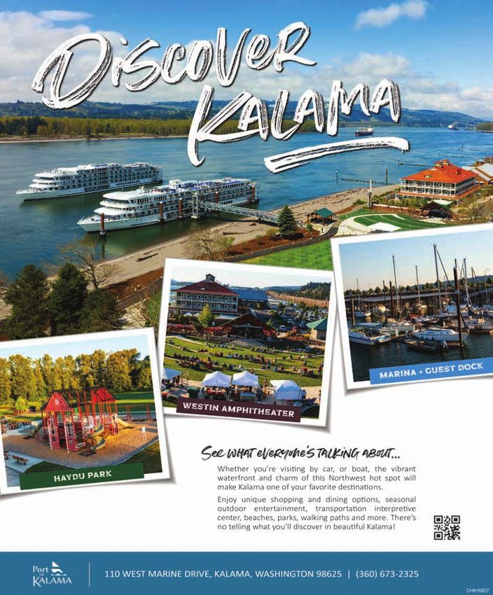
Your SW Washington Real Estate
                      & Mortgage Team
              You Dream It! We Make It a Reality!
CH615557 db

              Residential | 2nd Homes | Construction | Investment | Small Commercial

                                                                                                                      CH615557 db
              If you have a vision of your dream
                home, we specialize in mortgage
                                                                                                       NMLS# 113149

                   prequalifying you for a home,
                  Sarah helping you identify and
               reviewing homes and getting you
                   to an on time close! Call for a   Sarah Villanueva               Jeffrey Beard
                “World Class Experience” today!      Your Neighborhood WA Realtor   Mortgage Loan Officer

                        360.449.9496                 360.836.1103                   360.449.9496
                                                     sarahv@johnlscott.com          jeffreybeard.com
                                                     sarahv.johnlscott.com          Prestige Mortgage
                                                                                    Services, Inc.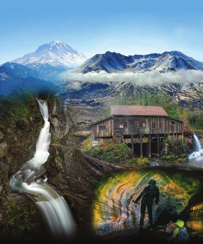
CT Publishing Credits
CEO                            Reporters
Coralee Taylor                 Emily Fitzgerald
                               Isabel Vander Stoep
Publisher
                               Daniel Warn
Chad Taylor
                               Matthew Zylstra
Vice President                 Rick Bannan
Franklin Taylor                Sebastian Rubino
                               Jacob Dimond
CMO
Kyle McKerricher               Sports Reporters
                               Alec Dietz
Editor-in-Chief
Eric Schwartz                  Aaron VanTuyl

Regional Editor                Photographer
Justyna Tomtas                 Jared Wenzelburger
                               Elizabeth Hill
Sales Manager
Brian Watson                   Sign Pro
                               Coralee Taylor
Sales Media Team               Mike Willis
Crystal Starr
Nik Casetta                    Customer Service
Billy Armstrong                Representatives
                               Ronda Barr
Elijah White
                               Sarah Burdick
                               Cheyenne Denman

    For any additional information, please call
       The Chronicle, The Reflector, or the
     Nisqually Valley News at 360-736-3311

  Visitor Guide Design by The Silver Agency. Cover and
  coloring page illustration by Shawn Murphy & content
  designed by Tara Watson.
  Visitor Guide Copyright © 2022, The Silver Agency. All
  Rights Reserved. The Silver Agency does not assume any
  responsibility for errors or omissions.
Table of Contents
Southwest Washington 1 25. Alpine Lakes 23
26. Lewis & Clark State Park 24
Mount St. Helens 2 27. Cowlitz Trout Hatchery 26
1. Johnston Ridge Observatory 3 28. Jackson House 26
2. Windy Ridge Interpretive Site 4 29. Carlisle Lake & Onalaska 26
3. The Ape Cave 4 30. Morton, Mossyrock & Mineral 27
4. Coldwater Lake Picnic & Boating Site 5
Thurston & Lewis Counties 29
5. Lava Canyon Trail 6
31. Yelm 29
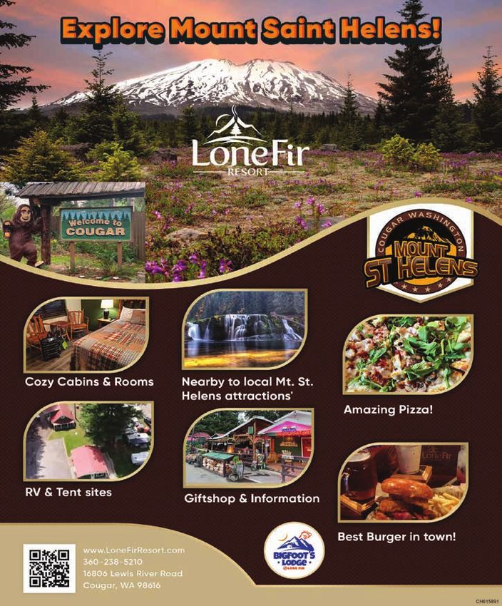
6. The Town of Cougar 7
32. Northwest Trek Wildlife Park 30
7. Climb to the Summit of Mount St. Helens 7
33. Washington Capitol Campus 30
8. Science & Learning Center at Coldwater 8
34. Wolf Haven 33
9. Randle 8
35. South Sound Speedway 33
10. White Pass Country Historical Museum 9
36. Nisqually Red Wind Casino 34
Mount Rainier 11 37. Great Wolf Lodge 34
11. Ashford 13 38. Lucky Eagle Casino and Hotel 35
12. Grove of the Patriarchs 13 39. Tenino 35
13. Wonderland Trail 14 40. Mima Mounds 36
14. Ohanapecosh 14 41. Offut Lake Resort 36
15. Paradise 15 42. Lattin’s Country Cider Mill & Farm 36
16. Sunrise 16 43. Scatter Creek Wildlife Area 37
17. Carbon River and Mowich Lake 16 44. Millersylvania State Park 37
18. Longmire 18 45. Joint Base Lewis-McChord 39
19. Goat Rocks Wilderness 19 46. Billy Frank Jr. Nisqually National Wildlife
Refuge 39
20. Packwood 19
47. Centralia 39
White Pass Scenic Byway 21 48. Seminary Hill Natural Area 41
49. Southwest Washington Fairgrounds 41
21. White Pass Ski Area 21
50. Rollerdrome 41
22. Riffe Lake 21
51. Chehalis 43
23. Mayfield Lake 22
52. Willapa Hills Trail 43
24. Ike Kinswa State Park 22
PHOTO ACKNOWLEDGMENTS: Pictured on the cover from top left and moving clockwise are Mount Rainier, Mount St. Helens, the Cedar Creek Grist Mill, Ape
Cave and Christine Falls at Mount Rainier National Park. Cover photographs were provided by Jared Wenzelburger, Sebastian Rubino and Pete Caster. Inside this
publication, photographs from Nisqually Valley News, The Chronicle and The Reflector are used, along with images from our partners and sites featured in the guide.

        53. Veterans Memorial Museum                             44                              81. Cedar Creek Grist Mill                               58

        54. Take a Ride on State Route 6                         44                              82. La Center                                            61

        55. Winlock                                              44                              83. Pearson Air Museum                                   61

        56. Toledo                                               45                              84. Camas Potholes                                       61

        57. McMurphy Park                                        45                              85. Esther Short Park                                    62

                                                                                                 86. Vancouver Barracks                                   63
Cowlitz & Clark Counties                                           47                            87. Clark County Event Center at the
        58. Castle Rock                                          47                              Fairgrounds                                              63

        59. Lake Sacajawea Park                                  48                              88. Woodland                                             63

        60. Cowlitz County Historical Museum                     48                              89. Paradise Point State Park                            64

        61. Daybreak Regional Park                               48                              90. Bells Mountain Trail                                 64

        62. Lake Merwin                                          49                              91. Lacamas Regional Park                                64

        63. Gifford Pinchot National Forest                      50                              92. Washougal                                            64

        64. Hulda Klager Lilac Gardens                           50                              93. Downtown Camas                                       66

        65. Mount St. Helens Visitors Center, Castle                                             94. Vancouver's Waterfront                               66
        Rock                                         51

        66. Holland America Flower Gardens                       51                      More to Explore                                                     67
        67. North Clark County Historical Museum 51                                              95. Columbia River Gorge National Scenic
                                                                                                 Area                                                     67
        68. Battle Ground                                        52
                                                                                                 96. Pendleton Woolen Mill                                67
        69. Pomeroy Farm                                         52
                                                                                                 97. Beacon Rock State Park                               67
        70. Clark County Historical Museum                       52
                                                                                                 98. Bonneville Lock and Dam                              68
        71. ilani                                                53
                                                                                                 99. Columbia Gorge Interpretive Center
        72. Ridgefield National Wildlife Refuge                  53                              Museum                                                   68
        73. Fort Vancouver                                       53                              100. Visit the Coastline                                 68
        74. Battle Ground Lake State Park                        54

        75. Chelatchie Prairie Railroad                          54                      Community Resources                                                70
        76. Moulton Falls Regional Park                          55

        77. Lewis River Recreation Area                          55
                                                                                         Kids Corner                                                        71
                                                                                                 50 State License Plate Game                              71
        78. Ridgefield                                           57
                                                                                                 Southwest Washington Crossword Puzzle 72
        79. Port of Kalama                                       57
                                                                                                 Southwest Washington Word Scramble                       72
        80. Downtown Vancouver                                   58
                                                                                                 Color Southwest Washington                               73
100 Places to See in
    Southwest Washington
Visitors to the Pacific Northwest often have          sandstone architecture and our state’s Capitol,
two destinations in mind — the coastline              then moving through Lewis County and into
                                                      Cowlitz and Clark counties, where communities
of the Pacific Ocean and the white-capped
                                                      offer much more than just a gateway to the
peaks of the Cascade Mountain Range.                  mountains and beaches of the region.
Between those two wonderful and mesmerizing           We hope you’ll use this guide as a jumping point to
locations, though, travelers will find a              discover all of the businesses, parks and attractions
swath of Southwest Washington teeming                 that help make Southwest Washington a unique
with opportunities for adventure.                     destination you’ll almost certainly want to visit again.
In this visitors guide, we identify just 100 of the   Along with this guide, seek out the online
thousands of options available for those visiting     homes of our partners: The Yelm Chamber of
our wonderful corner of the world. Starting in        Commerce (yelmchamber.com), the Centralia-
the mountains — with the crown jewel of the           Chehalis Chamber of Commerce (chamberway.
region Mount Rainier and its explosive neighbor       com), the Ridgefield Chamber of Commerce
Mount St. Helens — we identify some of the            (ridgefieldchamberofcommerce.com) and the
best places to hike, camp, fish and take in the       Cowlitz Tribe (cowlitz.org) for localized and
outdoors in ways few other places provide.            updated information throughout the year.
From there, we move north to south, starting          Thank you for visiting Southwest Washington.
in Thurston County where one can find wolves,         We know you’ll enjoy your stay.

1                                                         Southwest Washington Visitors Guide • 2022-2023
Mount St. Helens
                                                                                                Mt. St. Helen’s Summit

Unlike Mount Rainier, its unspoiled                      Several hikes offer the opportunity to view the
neighbor on the Cascade mountain range,                  mountain from a variety of angles, including the
                                                         Hummocks Trail, a two-mile loop around several
Mount St. Helens is still recovering from
                                                         hummocks that allow for views of the mountain.
a devastating eruption 42 years ago.
                                                         Delving into moderate difficulty, the Hummocks
The Mount St. Helens National Volcanic                   to Johnston Ridge hike is a nearly 9-mile round
Monument stands as a living testament to nature’s        trip that gains at least 2,000 feet in elevation
regenerative power. It’s easily accessible from          while twisting and turning to offer consistently
Cowlitz, Skamania and Lewis counties for those           changing views of the north flank of the volcano.
who want to get a close-up view of the mountain          To get even more majestic views of the mountain —
and the surrounding area by car or by foot.              and maybe more importantly for some, away from
Evidence of the destruction still marks the              the throngs at Johnston Ridge Observatory — park
landscape, with pieces of the mountain known as          at the far end of the observatory lot and take the
hummocks deposited throughout the blast zone.            Boundary Trail to Harry’s Ridge or Coldwater Peak.
The signs of regeneration are best explored closely.     But the north side of the volcano isn’t home to
Red paintbrush peeks through the ground along            the only adventure Mount St. Helens offers.
several hiking trails, and small trees insulated         On the south side, visitors can find ample
by snow at the time of the blast have begun              camping and recreation options.
to mature, especially in the Mount Margaret              The mountain town of Cougar offers a base
area. Wildlife has begun to call the area home           camp of sorts for adventures of all kinds — from
once again, and it’s not out of the realm of             climbing to the exploded summit of Mount St.
possibility to encounter a herd of deer or elk.          Helens to clamoring through the depths of the
To get the closest you can to the mountain — or          Ape Cave. Go high or go low, regardless you’re
even the crater itself — you’ll have to use your feet.   certain to find an unforgettable experience.
2022-2023 • Southwest Washington Visitors Guide                                                                          2
Mount St. Helens is truly an area to be                                              Johnston Ridge Observatory

explored in-depth, with much to offer an entire
family over the course of a few hours, a full
day trip or even a few days in the region.
The Washington Trails Association website
at wta.org offers detailed information on
several other hikes, complete with trip
reports from people who have been there
and can offer advice for the trail.
The Mount St. Helens Institute, a nonprofit
organization aiming to enhance people’s
experiences at the mountain, offers a wide variety
of activities from summit climbs with geologists to
its annual Volcano Outdoor School and Volcano
Camp. For more information on their offerings,
visit mshinstitute.org or follow them on Facebook.
While those resources will provide the full depth
of experiences available to visitors, we’ll use
Mount St. Helens as a jumping point to highlight
100 must-see stops and attractions that are
either near the volcano or on the road to it.

                                                                                     Johnston Ridge Observatory

1.                  Johnston Ridge Observatory

     The Johnston Ridge Observatory is
open seasonally and is located on Johnston
Ridge in the center of the 1980 blast zone
about 5 miles north of the Mount St. Helens
summit. The ridge was named in honor of
David Johnston, the United States Geological
Survey (USGS) volcanologist who was on
duty at the USGS Coldwater II observation
point during the May 18, 1980, eruption. He
was one of 57 people who lost their lives in
the eruption. The observatory building houses
seismic, deformation and other monitoring
equipment that relays data to the USGS
Cascades Volcano Observatory for analysis.
It’s also one of the best places to peer into
the volcano and contemplate the explosive
damage wrought by the 1980 eruption.
It’s located at the end of State Route 504, which
can be reached from Castle Rock or Toledo off of
Interstate 5. The observatory hosts interpretive
displays that tell the biological, geological and
human story of Mount St. Helens. Visitors to

3                                                     Southwest Washington Visitors Guide • 2022-2023
Windy Ridge Interpretive Site

Johnston Ridge Observatory can enjoy multiple         25 for 19 miles to Forest Road 99. Turn right
award-winning films, listen to ranger talks,          on Forest Road 99 and drive 16 miles until it
observe the landscape, purchase souvenirs, set off    terminates at Windy Ridge. The site can also
on a hike or get a light lunch from the food cart.    be reached traveling north from Cougar.
Learn more: visitmtsthelens.com                       Remember, this site is only open seasonally,
                                                      most often opening in May or June and closing as
                                                      snowfall arrives. Road conditions can vary greatly,
                                                      so be prepared for a potentially bumpy ride.

2.                Windy Ridge Interpretive Site

      Located just 5 miles from Mount St.
                                                      Learn more: fs.usda.gov/recarea/giffordpinchot

Helens, the Windy Ridge Interpretive Site
provides a close-up view of the volcano's crater
and a breathtaking panorama of a landscape
radically changed during the 1980 eruption and        3.                                 The Ape Cave

                                                           If you’re looking for some climbing, some
landslide. Below you lies Spirit Lake, with its       slime and some Bigfoot lore, the Ape Cave at
floating log mat of huge trees swept into it during   the south end of Mount St. Helens may be the
the eruption. Beyond, view a plain of pumice          sweet spot. The pitch-black cave provides a trek
and ash and denuded hills, still fairly barren        into where lava pulsated some 2,000 years ago.
but greening with vegetation. Climb a 368-step
sand ladder for a higher view. Read interpretive      When you descend into the darkness, take the
signs to learn about the events and people of the     “upper cave” path for a longer journey (about
eruption. During summer, join an interpretive         a mile and a half), which demands a bit of
program presented at the site's amphitheater.         scrambling. And while you should keep your
The site is accessible and memorable for all.         eyes on your footing, make sure to catch a
                                                      glimpse of the glittery — and oftentimes slimy
Windy Ridge Interpretive Site provides access to      — ceiling. Lava stalactites punctuate the rocky
Truman Trail #207 and Willow Springs                  walls, which transform from broad openings to
Trail #207A.                                          small, watch-your-head crevices as you walk.
From Randle on U.S. Highway 12, travel south          According to the U.S. Forest Service, the Ape
on State Route 131 until the road forks. Stay to      Cave is the third longest lava tube in North
the right on State Route 131, which becomes           America at 2.5 miles. It was discovered in 1947
Forest Road 25. Travel south on Forest Road
2022-2023 • Southwest Washington Visitors Guide                                                                         4
The Ape Cave                                     young forest situated on a mossy lava field.
                                                     Be sure to reserve your spot at recreation.gov,
                                                     and bring your coat and plenty of light sources.
                                                     To get to the Ape Cave from Interstate 5, take Exit
                                                     22 and turn left onto Dike Access Road. Continue
                                                     onto old Pacific Highway and then take a slight
                                                     left on East Scott Avenue. Take the second exit
                                                     at the traffic circle onto Lewis River Road where
                                                     you’ll travel for about 30 miles. Continue onto
                                                     Road 90 before eventually turning onto National
                                                     Forest Road 83. Take a left at National Forest
                                                     Road 8303 and follow the signs to the cave.
by Lawrence Johnson, a logger, but was only
                                                     Curious how the cave got its name? Find the story
explored a few years later by a troop of Scouts,
                                                     under “The Classics” at bigfootencounters.com.
who lowered themselves into the cave and named
it after their sponsor, the St. Helens Apes.
The genesis of the cave itself stems from a
kind of eruption that was unusual for the
Cascades: a basaltic eruption, which involves        4.       Coldwater Lake Picnic & Boating Site

                                                          Coldwater Lake Recreation Area is located
fluid lava. It’s the only known basaltic eruption
                                                     45 miles east of Castle Rock in the heart of
of the volcano, and it sent lava pouring
                                                     the blast zone near the Science and Learning
down the south side of the mountain.
                                                     Center at Coldwater and Johnston Ridge
On your way out, stop at the Trail of Two Forests,   Observatory. Experience the effect the May 18,
where a boardwalk trail meanders through a           1980, eruption had on the Coldwater Valley,

5                                                     Southwest Washington Visitors Guide • 2022-2023
CH615694cs.rg
Coldwater Lake
including creating a brand new lake. Kayaking
is popular here. Combustion engines are
prohibited on the lake, but anglers reach trophy
trout by electric motors, rowing, or kicking. See
the restrictions section for more information.
The 0.6 miles accessible Birth of a Lake
Interpretive Trail allows visitors to enjoy
close up views of Coldwater Lake.
Learn more: fs.usda.gov/recarea/giffordpinchot
5. Lava Canyon Trail
Views of a rushing ribbon of pools and
waterfalls await you on the Lava Canyon Trail on
the south side of Mount St. Helens, not far from
the welcoming town of Cougar. Three sections of
the trail, one section which is accessible, provide
opportunities for all. Due to the closure of the
Lava Canyon Suspension Bridge, the 1.4 mile
upper loop is not possible. But the first small
bridge remains open for crossing the river. You
may still walk down both sides of the river to the
Lava Canyon Trail
2022-2023 • Southwest Washington Visitors Guide 6suspension bridge, you just can't cross it. The broadens out as it approaches the Smith Creek
lower section past the suspension bridge is open. Valley. The trail ends at Smith Creek Trail #225.
The first 1/3 mile is paved and accessible. Stroll Learn more: fs.usda.gov/recarea/giffordpinchot
down some switchbacks and past lovely views
of the Muddy River. Stop to read interpretive
signs explaining the canyon’s geological past.
After the first 1/3 mile, the pavement ends.
To the right, cross a steel bridge, gaze down
6. The Town of Cougar
With all the potential adventures around
on the rushing Muddy River and explore the Mount St. Helens, you’ll need to fuel up at some
river’s east side or continue straight on the main point. This quiet-in-the-winter, bustling-in-the-
trail for another 0.4 miles to the suspension summer mountain town offers the perfect respite.
bridge. Normally, you can cross the suspension Cougar is an unincorporated community in
bridge to make a 1.4 mile loop, but due to the Cowlitz County. It’s located 28 miles northeast of
bridge’s closure, this is currently not possible. Woodland along State Route 503 and is situated
On the main trail, beyond the suspension bridge, along the northwest bank of Yale Lake, a reservoir
the terrain becomes more difficult, descending on the Lewis River. Surrounding the town you’ll
steeply into the canyon. This section is not find campgrounds, trails and many different
recommended for people uncomfortable with options for recreation on — or in — the water. The
heights. The trail crosses an exposed cliff face town also includes a bar and restaurant, a supply
followed by a water crossing with a cable grab- store and a fueling station, amid other amenities.
line. A 30-foot metal ladder descends a vertical Learn more: columbiariverimages.
cliff, providing access to the canyon's deepest com/Regions/Places/cougar.html
recesses and roaring waterfalls. The canyon
Lewis River Falls
7. Climb to the Summit of Mount St. Helens
Ever thought about climbing to the top of an
active volcano? If so, you’ll never find a greater
opportunity than Mount St. Helens, where you
don’t have to be an experienced mountaineer
to reach the top. The summit is climbed all
year, though the most popular times are in the
7 Southwest Washington Visitors Guide • 2022-2023Science & Learning Center at Coldwater
late spring through early fall. Most climbers outside in the heart of the blast zone.
use the Monitor Ridge Route from Climbers The Science and Learning Center is located at
Bivouac. A climbing permit is required and can milepost 43 on State Route 504, approximately
be obtained at recreation.gov/permits/4675309. 10 miles west of Johnston Ridge Observatory.
This route gains 4,500 feet in 5 miles to the Near the Science and Learning Center is:
crater rim at 8,365 feet elevation. Although • The Winds of Change Trail with a 1/4 mile
strenuous, this non-technical climb is paved loop offering views of the Toutle Valley.
suitable for people in good physical condition
who are comfortable scrambling on steep, • The Elk Bench Trail connects with the Lakes
rugged terrain. Most climbers complete Trail, providing stunning views of Coldwater
the round trip in seven to 12 hours. While Lake and frequent elk sightings along the way.
climbing to the crater rim is permitted, • A campground with stunning views of
entry into the crater is strictly prohibited. Mount St. Helens and Coldwater Lake
You’ll want to plan ahead. From April 1to May 14, that is available for group rentals.
there is a daily limit of 350 climbers. The limit is The center is an offering of the
110 climbers from May 15 to Oct. 31. From Nov. Mount St. Helens Institute.
1 to March 31, there is no limit on climbers. Learn more: mshinstitute.org
The closest town is Cougar.
Learn more: fs.usda.gov/recarea/
9.
giffordpinchot/recarea/?recid=81369 Randle
Randle, located along U.S. Highway 12,
is the northern gateway to Mount St. Helens
8. Science & Learning Center at Coldwater
The Science and Learning Center at
and Mount Adams backcountry. The rural area
around Randle is known locally as the “Big
Coldwater is a hands-on education center Bottom Valley,” describing the valley floor of
located 7 miles from the crater of Mount St. the Cowlitz River which is big, flat and fertile.
Helens off the road to Johnston Ridge. The Randle is a mainly residential community in
Science and Learning Center at Coldwater unincorporated Lewis County with a handful of
offers spectacular views and immersion restaurants, a grocery store and campgrounds
into the volcanic landscape and world just nearby. It has an active timber mill and is
2022-2023 • Southwest Washington Visitors Guide 8home to the ranger station for the Cowlitz
Valley Ranger District of the Gifford Pinchot
National Forest. Randle boasts access to the
Windy Ridge viewpoint of Mount St. Helens,
as well as the Mount Adams backcountry and
to a wide variety of outdoor recreation in the
forest. The Cowlitz River is a great fishing area
and the scenic beauty is beyond comparison.
The town is named for James L. Randle, the first
settler in 1886. The townsite was founded
in 1902.
One of the town’s largest celebrations comes
on the Fourth of July: the Big Bottom Blast.
Learn more: whitepassbyway.com/
attractions/byway-communities/randle
10. White Pass Country Historical Museum
Capturing and preserving the
history of the Upper Cowlitz Valley from
Kosmos to White Pass, the White Pass
Randle Country Historical Society offers educational
programs, interpretive discussions as
well as exhibits and displays featuring the
fascinating area history. Find the museum in
the former Packwood Elementary School.
Summer hours, starting Memorial Day
weekend and continuing through Labor
Day weekend, are Thursday, Friday and
Saturday from 11 a.m. to 4 p.m.
Winter hours start the Saturday following Labor
Day and are Saturdays from noon to 4 p.m.
It’s located at 12990 U.S.
Highway 12.
Learn more:
whitepasscountrymuseum.org
White Pass Country Historical Museum
CH615547 White Pass Country Historical Museum
9 Southwest Washington Visitors Guide • 2022-2023Mount Rainier Mt. St. Helen’s Summit
On a sunny day, you can catch a glimpse than just a destination in its own right, but an
of Mount Rainier from just about outdoors haven for anyone whose heart calls
the hills and peaks of the region home.
anywhere in Southwest Washington,
but if you get a little closer, Rainier Hiking and touring the Mount Rainier region
is best reserved for the day, but when it comes
becomes more than a beautiful view.
time to wind down, Mount Rainier National Park
It’s a perfect getaway for those wishing offers plenty of resources for campers, from
to escape for a prolonged day trip or full-service campsites to backcountry areas.
some extended time with nature. The Cougar Rock campground in the southwest
The mountain itself, reaching 14,410 feet, is section of the park is open from late May
probably the most recognized landmark in all of to late September, offering 173 campsites;
Washington state, and it’s the background picture Ohanapecosh in the southeast section offers 188
on most state license plates for good reason. sites; and White River offers 112 sites. All these
The active volcano is surrounded by lush forests,
alpine meadows and abundant wildlife.
The mountain itself presents quite the
challenge for climbers and can test even the
most hardened hikers, but most people will
be best served to simply visit areas such as
Paradise, Longmire and Ohanapecosh and
marvel at the enormity and beauty of the peak.
Mount Rainier is part of a scenic region of the
Cascades that separates the east and west
sides of the state, making the mountain more
11 Southwest Washington Visitors Guide • 2022-2023campgrounds offer water, restrooms and fire grates; RVs and trailers are welcome, but visit nps.gov/mora for maximum length allowances. Reservations are also required at Cougar Rock and Ohanapecosh. For those wishing to camp in the wilderness, a permit is required. Pick one up from any of the visitor centers throughout the park. The 93-mile Wonderland Trail provides opportunities for wilderness camping, offering the opportunity to cache food at several points along the way. For a list of maps and other resources with which to plan a camping trip, visit nps.gov/mora/planyourvisit/maps.htm. From Interstate 5, Mount Rainier is best accessed by taking U.S. Highway 12 to Morton then bearing north on State Route 7. Head north into Elbe, then take State Route 706 east all the way to the park entrance. A National Park Pass is required; for more information visit nps.gov/mora. Additional information can be found online at visitrainier.com. 2022-2023 • Southwest Washington Visitors Guide 12
High Rock Lookout Near Ashford                                          Grove of the Patriarchs

11.      Just 6 miles outside the Nisqually
                                             Ashford
                                                                         Visitors will find a collection of cabins, vacation
                                                                         rentals, inns and a few campgrounds.
Entrance to Mount Rainier National Park                                  Area restaurants include family-friendly grills,
sits the mountain community of Ashford.                                  convenient cafes and historic inns. Of course,
Tucked away in the forested foothills,                                   recreation abounds with summertime hiking
discover lodging establishments from cozy                                trails and winter snowshoe routes all in
cabins to friendly motels, all serving as a                              close proximity. Mt. Tahoma Trail System is
base camp for Mount Rainier adventures.                                  accessed just a few miles east. Several shops
Usually, the fastest route is to take Interstate 5                       and galleries in town offer exquisite, original
southbound to State Route 512, then to State                             artworks and outdoor shops provide gear for
Route 706.                                                               year-round adventure. The 80-acre Ashford
                                                                         County Park, located on Highway 706, offers
                                                                         a children’s play area, accessible trails and a
                                                                         restroom facility. Recent additions to the park
                                                                         include an amphitheater, great lawn, additional
                                                                         trails, additional parking, utility infrastructure
                                                                         and a set of new restrooms. This is a great
                                                                         venue for large groups or family gatherings.
                                                                         More information: visitrainier.com/ashford

                                                                         12.                       Grove of the Patriarchs

                                                                                   Tucked away in the northeastern tip of
                                                                         Lewis County in Mount Rainier National Park
                                                                         lies some of Washington’s mightiest evergreens.
                                                                         With some of the trees over 1,000 years old and
                                                                         many over 25 feet around, walkers and hikers
                                                                         of all abilities can enjoy this primitive grove
                                                                         on the zero elevation path. To get there, follow
                                                                         Highway 206 past Ashford to Stevens Canyon.
                                                                         National Park Pass required.
                                                                         Learn more:
                                                                         visitrainier.com/grove-of-the-patriarchs-2
13                                                                        Southwest Washington Visitors Guide • 2022-2023
14. Located in the southeast corner of the
Ohanapecosh
park, Ohanapecosh, named for a Taidnapam
(Upper Cowlitz) Indian habitation site along the
river, is thought to mean “standing at the edge.”
Situated among Douglas firs, western red cedars,
and western hemlocks, visitors to Ohanapecosh
can experience the beauty and complexity of an
Wonderland Trail
old-growth forest. The east side of the park is also
somewhat drier and sunnier than the west side,
making it a good destination when Paradise and
13. Wonderland Trail
Sixteen miles east of Ashford lies the
Longmire are wet and foggy. Ohanapecosh is not
accessible in winter. Ohanapecosh is located 3
miles north of the park boundary on State Route
Longmire visitor center, the first established
123 and 42 miles east of the Nisqually Entrance.
park entrance for Mount Rainier National
Park. Starting from here, the adventurous The Ohanapecosh Visitor Center, open from
hiker can go for 6 miles to Paradise or 93 June to early October, offers exhibits, guided
miles to circle Mount Rainier. Plan trips interpretive programs and book sales.
according to ability and equipment. The Ohanapecosh Campground and picnic
Wilderness Pass required for camping. area is located on the banks of the peaceful
Ohanapecosh River, within a majestic old-growth
Learn more: nps.gov/mora/planyourvisit/
forest. Like the visitor center, the campground
the-wonderland-trail.htm
My entire clientele is based off of referrals; you WANT to work with Diana Rutherford because she
goes above and beyond the scope of being a Realtor and genuinely has your best interest at heart.
I fully believe that we are better as a community when we put each other’s needs at the
forefront as a business owner! That is why I donate 10% of every commission check to a
charity of my client’ s choosing. Whether that is a major Charity, local non-profit or a family
that may need a little pick-me-up.
As a former D1 softball player, I truly understand the meaning of being a ‘teammate’. That
is how I run my business as a sole-prenuer, that is how I communicate with my clients, my
contractors, my family and friends.
CH615840 db
Diana Rutherford received ‘Top Agent’ award in 2021 for Realty One Group
Diana Rutherford athomewithdiana
Realty One Group Prestige Diana@RealtybyRutherford.com
1509 SE Solomon Loop 98683
360-904-0286 RealtybyRutherford
2022-2023 • Southwest Washington Visitors Guide 1415. Paradise
Paradise is famous for its glorious
views and wildflower meadows. When James
Longmire's daughter-in-law, Martha, first saw this
site, she exclaimed, "Oh, what a paradise!" The
park's main visitor center, the Henry M. Jackson
Memorial Visitor Center, is located in the upper
parking area. Paradise is also the primary winter-
use area in the park, receiving on average 643
inches of snow a year. Winter activities include
Ohanapecosh snowshoeing, cross-country skiing and sledding.
is open from late May to early October. The road between Longmire and Paradise is
plowed, but closes at night during the winter.
More sites nearby: Paradise is located 19 miles east of the Nisqually
• Box Canyon — Located on Stevens Canyon Entrance and 12 miles east of Longmire.
Road 12 miles west of Ohanapecosh. From The Henry M. Jackson Memorial Visitor Center
the bridge, gaze 180 feet below at water at Paradise offers general information, exhibits,
rushing through a narrow slot canyon carved the park film, guided ranger programs, a book
by the Muddy Fork of the Cowlitz River. and gift store and a cafeteria. The visitor
• Reflection Lakes — Drive west 19 miles center is usually open daily from May to early
from Ohanapecosh on Stevens Canyon Road October. From mid-October through April, it is
for a possible glimpse of Mount Rainier's usually open only on weekends and holidays.
reflection in these subalpine lakes. The historic Paradise Inn, a concessioner-
• Inspiration Point — This large pullout is operated hotel, offers lodging, a dining
20 miles west of Ohanapecosh on Stevens room and a gift shop. The Paradise Inn
Canyon Road. It offers spectacular views of is usually open from mid-May to early-
Mount Rainier and the Tatoosh Range. October and is closed in the winter.
Learn more: nps.gov/mora/ The Guide House houses the Paradise Climbing
planyourvisit/ohanapecosh.htm Information Center, where visitors can obtain
Paradise
15 Southwest Washington Visitors Guide • 2022-2023Sunrise
climbing permits and hiking and
backcountry camping information. Carbon River
The historic Paradise Ranger The Sunrise Day Lodge is open from early
Station is also located in Paradise. Information July to late September. It offers food service
services formerly available at the Paradise Ranger and a gift shop. There is no overnight
Station are now available at the Guide House. lodging at the Sunrise Day Lodge.
Learn more: The White River Campground and picnic area is
nps.gov/mora/planyourvisit/paradise.htm located 12 miles from the Sunrise Visitor Center.
Learn more:
nps.gov/mora/planyourvisit/sunrise.htm
16. Sunrise
At an elevation of 6,400 feet, Sunrise
is the highest point that can be reached by
vehicle in Mount Rainier National Park. In 17. Carbon River and Mowich Lake
Named for coal deposits found
summer, mountain meadows abound with
in the area, Carbon River is located in
wildflowers. On clear summer days, Sunrise
the park’s northwest corner. This part of
provides breathtaking views of Mount Rainier
Mount Rainier National Park receives
and Emmons Glacier. Sunrise Point offers
consistently high amounts of rainfall so the
nearly 360-degree views of the surrounding
climate and plant communities found here
valleys, Mount Rainier, and other volcanoes
resemble that of a temperate rainforest.
in the Cascade Range such as Mount Adams.
These views and an excellent trail system make The Carbon River Road was washed out by
Sunrise the second most visited location in the the 2006 flood and is closed to vehicles past
park. Sunrise is located 60 miles northeast of the the park boundary. Bicycle and pedestrian
Nisqually Entrance and 14 miles northwest of the traffic are permitted on the remainder of
Sunrise/White River turnoff on State Route 410. the road inside the park, which has been
converted into a trail. Carbon is reached via the
The Sunrise Road usually opens in late June
Carbon River Road, off of State Route 165.
or early July and closes in late September to
early October. Set in a glacial basin surrounded by fragile
wildflower meadows, Mowich Lake is the largest
The Sunrise Visitor Center is open from early
and deepest lake in Mount Rainier National
July to early September and is closed in winter.
Park. Mowich Lake is open for fishing and non-
Here visitors will find exhibits, guided interpretive
motorized boating. The area is generally open
programs, book sales and a picnic area.
mid-July to mid-October. Mowich is reached
2022-2023 • Southwest Washington Visitors Guide 16via State Route 165. The road is unpaved Building, completed in 1930, still holds offices
after the first 3 miles and may be rough. for park staff and is home to the Longmire
The Ipsut Creek Campground is located Wilderness Information Center (current park
5 miles from the Carbon River Entrance. administration offices are located at Tahoma
Due to the 2006 flood, the road is closed to Woods, outside of the park along State Route
vehicles; the campground is open to hikers 706). All of Longmire is now designated a
with a wilderness camping permit. National Historic District. Longmire is located
in the southwest corner of the park and is
The Mowich Lake Campground and Tolmie 6.5 miles east of the Nisqually Entrance.
Peak Trailhead/Mowich Lake picnic area are
located 6 miles from the Mowich Entrance. Longmire is open year-round.
Both the Mowich Lake campground and picnic The Longmire Museum, usually open daily all
area are open midsummer to early fall. year, offers exhibits, information and books sales.
The Carbon River area includes old- The Wilderness Information Center, usually open
growth forest and inland temperate rain daily from late May to early October and closed
forest. The Carbon Glacier is the lowest in winter, is where visitors can obtain wilderness
elevation glacier in the lower 48 states. permits and hiking and backcountry camping
The Mowich Lake area provides a information. In winter, visitors can obtain climbing
gateway to spectacular subalpine lakes and wilderness permits at the Longmire Museum.
and meadows. Subalpine meadows The National Park Inn, a concessioner-
are very sensitive to disturbance, so operated hotel, restaurant and gift shop is
please stay on the trails at all times. usually open daily all year. The article, The
Learn more about nearby hikes here: National Park Inn, provides an overview
nps.gov/mora/planyourvisit/carbon- of the history of this iconic inn.
river-and-mowich.htm Cougar Rock Campground and picnic
area, 2 miles east of Longmire, is usually
open from late May to early October.
18. Longmire Nearby attractions:
• Westside Road — Begins 1 mile east
With the establishment of Mount Rainier of Nisqually Entrance. Road is closed to
National Park in 1899, Longmire became park vehicles beyond the gate at Dry Creek,
headquarters. The site had previously served but accessible for biking and walking.
as James Longmire's homestead, lodging
and mineral springs resort. Although park • Christine Falls — Located 4 miles
headquarters are no longer at Longmire, the east of Longmire, a short walk from
original 1916 headquarters building houses the pullout offers a classic view of the
a museum that tells the story of the early falls below the rustic stone bridge.
days of the park. Across the street from the • Glacier Bridge — 5 miles from Longmire
museum, the "newer" Longmire Administration heading toward Paradise. The tall bridge
has excellent views of the Nisqually Valley,
though the Nisqually Glacier, which
once reached the location of the bridge,
has since retreated up the valley.
• Ricksecker Point Road — This one-way road
begins 6 miles east of Longmire and offers
fantastic views of Mount Rainier, Nisqually Valley
and the Tatoosh Range. It’s open in summer only.
Longmire at Kautz Creek
2022-2023 • Southwest Washington Visitors Guide 18Goat Rocks Wilderness Goat Rocks
19. Goat Rocks Wilderness
Named for the numerous mountain
goat families who call this area their home,
the Goat Rocks Wilderness covers 108,023
acres across Lewis and Yakima counties.
Backpackers from far and wide venture to
this wilderness area in the summertime for its
challenging technical hikes, pristine alpine lakes
and panoramic views of the Cascade Range.
The Goat Rocks features a 120-mile trail system,
much of which stays above the timberline. Hikers Packwood
will see marmots and pikas sunbathing on the
rocks during those few months without snow.
20.
Miles of huckleberry bushes dotted by hungry
Packwood
gray jays will guide hikers up twisted paths
until they reach sweeping fields of heathers. Set at the base of the Tatoosh Range
The Pacific Crest Trail wanders north- and on the banks of the Cowlitz River, Packwood
south through the middle of the is surrounded by dramatic natural landscapes,
wilderness for 31.1 miles and connects most of which are in public ownership. Packwood,
with 14 other trails along the way. located less than 10 miles from the Ohanapecosh
entrance to Mount Rainier National Park, also
In order to preserve this idyllic wilderness
has a fairly direct connection to the Nisqually
area, dogs and other pets are not allowed and
entrance via Skate Creek Road during the
fires are prohibited above 5,000 foot elevation.
summer months. The area offers a wide range of
Backpackers and hikers should always pack
lodging near Mount Rainier, Mount St. Helens,
trash out and be sure to leave no trace.
and the Gifford-Pinchot National Forest in
To reach the Goat Rocks Wilderness, travel the summer. Packwood provides lodging for
2.7 miles west of Packwood on U.S. Highway White Pass Ski Area skiers and snowshoers
12 until turning left on Forest Road 21. Stay during the winter. The Cowlitz River comes
on Forest Road 21 for 13 miles, then take a crashing off a glacier high on the flanks of
slight left toward Forest Road 2150. Follow Mount Rainier and winds through Packwood.
2150 and take the 045 spur to the trailhead. Steelhead in the river makes fishing wonderful.
Learn more: fs.usda.gov/recarea/ Mushrooms and huckleberries abound in the
giffordpinchot/recarea/?recid=79414 forests. Camping and lodging provide a perfect
respite for adventure and leisure travelers.
19 Southwest Washington Visitors Guide • 2022-2023Proximity to Mount Rainier National Park,
White Pass Ski Resort and the Cowlitz River BATTLE
CH615687 db
make this area a base camp for recreation.
The town of Packwood has historically GROUND
relied on the forest products industry as an CINEMA
economic engine, supplemented by government 1700 SW 9th Avenue
Showtimes (360) 666-7200
employment (via the National Forest and www.BattleGroundCinema.com
Park Services) and seasonal tourism.
In operation for more than 40 years, the
Packwood Flea Market is traditionally held
on Memorial and Labor Day weekends. • Safe and Clean: Strictly following all local,
CDC, and CinemaSafe COVID-19 guidelines
Vendors typically begin to set up their booths
on the Thursday of the holiday weekends. • $5 Super Tuesday every week, all movies!
The multi-day event attracts hundreds of vendors • Student and Military discounts
along with large crowds of shoppers. Visitors • Serving Beer, Wine, Cider and Hard Seltzers
can browse an assortment of food, antiques, for adults -- try our Date Night Combo!
novelties, handcrafted artisan gifts, upcycled
• New concessions items including Costco
items, art and more. The Packwood Flea Chicken Bakes, cotton candy, and hot pretzels!
Market is considered to be one of the largest
flea markets in the western United States. Follow us on our social accounts for contests,
movie trailers, announcements, and more:
Learn more: packwoodvisitorcenter.com
C!j @battlegroundclnema
2022-2023 • Southwest Washington Visitors Guide 20White Pass White Pass Ski Area
Scenic Byway
brown trout. Rainbow and cutthroat trout are
also available. Landlocked salmon rules apply.
21. White Pass Ski Area
Fifty-four miles east of Morton
Other warm water species present include
brown bullheads, along with a few bluegill and
and 54 miles west of Yakima lies one of crappie. There are no kokanee in Riffe Lake.
Washington’s finest ski areas. At White Pass, Mossyrock Park, near the west end on the
skiers of all abilities can go out for full or south side of the dam, has camping facilities
half days. Lessons, rentals and meals in that can be reserved by calling 360-983-3900.
the lodge are all available to purchase. Mossyrock Park boat launch remains usable
Learn more: skiwhitepass.com during most low-water conditions. Boat launches
22. Riffe Lake
Riffe Lake, historically known as
Mossyrock Lake then as Davisson Lake, is
a reservoir formed by Mossyrock Dam. It is
a popular waterway for smallmouth bass.
The lake stretches more than 13 miles along
U.S. Highway 12 east of Mossyrock and
has a year-round open fishing season.
Riffe provides good fishing for landlocked coho
and Chinook salmon, plus an occasional large Riffe Lake
21 Southwest Washington Visitors Guide • 2022-2023at the east end (Kosmos and Taidnapam Park) best tiger muskie fishing is during the warmer
are not usable during low-water periods. months. Consult the current Sport Fishing Rules
Bank access is available on both sides near pamphlet for specific regulations at this lake.
the dam and at the Taidnapam Park "fishing Surplus hatchery Coho and fall Chinook may
bridge" near the upper end of the lake. Call be placed in the lake for additional fishing
the Tacoma Power toll-free fishing hotline at opportunity. Yellow perch are also caught in fair
888-502-8690 to check reservoir levels. numbers and a few largemouth bass are present.
The towns of Mayfield, Riffe and Kosmos are Boating access is available at a Lewis County
located under Riffe Lake — a result of building the park just off of Highway U.S. 12, at Ike Kinswa
Mayfield and Mossyrock dams in the 1960s. You State Park, and at a private resort. There is
can see the towns if the water level is low enough. fair shore fishing access at the state park and
at the Mossyrock Trout Hatchery. Call Tacoma
Learn more: wdfw.wa.gov/fishing/ Power's toll free fishing line at 888-502-8690.
locations/lowland-lakes/riffe-lake
Learn more: wdfw.wa.gov/fishing/
locations/lowland-lakes/mayfield-lake
23. Mayfield Lake
This reservoir was formed by the
construction of Mayfield Dam. It is managed
for catchable rainbow trout and warmwater
24. Ike Kinswa State Park
Ike Kinswa State Park is a great
species. Tiger muskies were introduced place to make summer memories. This classic
in 1993 to help control nuisance northern state park sits on Mayfield Lake amidst a
pikeminnow (squawfish) populations. rolling patchwork of farmland 20 miles east of
Interstate 5 and off U.S. Highway 12. Ike Kinswa
The lake is located about 3 miles west of provides idyllic days of boating, swimming
Mossyrock. The big attraction is tiger muskie and water sports for the whole family.
fishing. The state record is currently over 31
pounds; but larger ones are out there. The Fish for tiger muskie, largemouth bass, kokanee
and rainbow trout; launch the family boat for
Ike Kinswa State
Park More Info:
Mayfield Lake Ike Kinswa State Park
2022-2023 • Southwest Washington Visitors Guide 22Alpine Lakes
There are about 1,600 lakes at elevations
water sports, or bring kayaks and paddleboards of 2,500 feet above sea level throughout
for a mellow float. Kids can splash in the swim the state, according to the Washington
area until the air turns cool, the daylight fades and Department of Fish and Wildlife.
the smell of barbecue draws them back to camp.
Although many of the lakes at that altitude are
Campers can choose between quiet, forested free of fish, some do maintain their own self-
tent and RV sites or lakeside cabins and snuggle sustaining fish populations. Some, however,
in for the night after a busy day on the water. are stocked with fish through state programs.
Ike Kinswa State Park is a 421-acre camping “Fish are purposely put in the lake with the
park with 46,000 feet of freshwater shoreline expectation ... they’ll be caught. There’s not a lot
on the north side of Mayfield Lake. In addition of natural reproduction in a lot of these lakes, but
to its excellent boating, fishing and swimming
options, the park offers short hiking trails,
birding, wildlife viewing and two horseshoe pits.
More here:
parks.wa.gov/519/Ike-Kinswa
25. Alpine Lakes
The mountainous landscape of the
Cascades has long scratched the adventurous itch
of many an outdoors lover — fishermen included.
Alpine or high-altitude lakes, some off the
beaten path and some readily accessible from
a vehicle, are scattered throughout the region
and, often, provide a pristine view along with
the challenge of pulling in a juicy trout.
“Just those high lakes up around the wilderness
area, the Mount Adams wilderness area, are
pretty spectacular,” said Kenneth Wieman,
fisheries biologist for the Gifford Pinchot
National Forest Cowlitz Valley Ranger District.
23 Southwest Washington Visitors Guide • 2022-2023Lewis & Clark State Park
it’s a recreational opportunity afforded to you by
26.
the state and the forest service,” said Wieman. Lewis & Clark State Park
Wieman said rainbow trout and cutthroat trout
This cool forested space east of
are often provided by the stocking program.
Interstate 5 and south of Chehalis offers
“Created by colliding tectonic plates, and hiking and horseback riding through a rare
carved by glaciers and ice, high mountain lakes stand of old-growth trees on the historic north
in Washington offer anglers a recreational spur of the Oregon Trail. The park provides
experience unmatched by any other waters an all-American camping experience with
in the state. The fishing is spectacular in fire circles, an amphitheater and horseshoe
these high elevation gems but the experience pits. Your horse can even camp with you at
is punctuated by fantastic camping, hiking, one of the park's equestrian campsites.
wildlife watching and travels to and from
Boundless enjoyment awaits children and families
these unique angling opportunities,” reads
on lawns that double as playing fields, on miles
online literature from the Washington
of trails amidst lush ferns, gnarled snags, nurse
State Department of Fish and Wildlife.
logs and in cathedral-like thickets of giant trees.
Learn more:
While buildings and kitchen shelters may
wdfw.wa.gov/fishing/locations/high-lakes
be purely functional to the kids, adults and
history buffs will appreciate these structures.
Lewis and Clark State Park was developed
by the Civilian Conservation Corps (CCC)
in the 1930s, during the Great Depression,
and examples of the characteristic CCC
architecture can be found throughout the park.
Don't forget to visit Jackson House State Park
Heritage Site, just 2 miles to the north.
Lewis and Clark State Park is a 616-acre
camping park in a stand of old-growth forest.
Learn more:
parks.wa.gov/538/Lewis-Clark
2022-2023 • Southwest Washington Visitors Guide 2425 Southwest Washington Visitors Guide • 2022-2023
27.                     Cowlitz Trout Hatchery

         The Cowlitz Trout Hatchery produces
and releases over 1.5 million fish each year.
This hatchery is the main contributor of winter-
run and summer-run steelhead trout to the
Cowlitz River ranked as one of the state’s top
steelhead rivers. Sea-run cutthroat are also
released for recreational fishing. The hatchery
is located 6 miles downriver from Mayfield Dam
on the Cowlitz River. The no-fee Blue Creek
boat launch is located near the trout hatchery
with a large parking lot, restrooms and ADA-
compliant riverside fishing platforms. Access to
the area is found at Ethel, just 6 miles east of
Interstate 5 off the White Pass Scenic Byway.
The address is 165 Osprey Road, Toledo.
                                                                                                       Carlisle Lake
Learn more: whitepassbyway.com

                                                            29.                   Carlisle Lake & Onalaska

28.                              Jackson House

           The 1845 Jackson House was the
                                                                      Located off of State Route 508 not far
                                                            from U.S. Highway 12, Onalaska is an off-the-
first pioneer home built north of the Columbia              beaten-path gem that offers food and services
River. It’s located near Lewis and Clark State              for wandering adventurers. While the area is
Park. Take U.S. Highway 12 to Mary’s Corner                 rich in history, one of its most well known spots
and turn south on Jackson Highway, where                    is Carlisle Lake. The lake is a historic mill pond
you’ll see it just off the side of the road.                from the Carlisle Mill, circa 1914-1928. Visitors
                                                            can enjoy fishing, trails, exercise stations and
Learn more: 360-864-2643
                                                            the developing playground. If you arrive at the
                                                                   right time, you can observe fish being
                                                                   raised in the net pens by the Onalaska
                                                                   High School aquaculture program.
                                                                   Learn more:
                                                                   onalaskaalliance.org

                                                   Jackson House                                       Cowlitz River

2022-2023 • Southwest Washington Visitors Guide                                                                 26
and provide a welcoming atmosphere to visitors
and residents alike who enjoy outdoors activities,”
30. Morton, Mossyrock & Mineral
A trip down U.S. Highway 12 wouldn’t
the city states on its website. “The immediate
Mossyrock area lies within the Klickitat Creek
be complete without stops at the small towns that drainage basin which is known for its highly
help give East Lewis County its character. Morton fertile soils. Agricultural traditions remain alive
is home to “the granddaddy of all logging shows,” today with both large-scale and small-scale
the Loggers Jubilee. The logging competition and farming. With several large berry grower and
associated festival typically occurs the second tree farmers the area preserves its rural charm.
weekend of August. The town is also home to The influence of the nearby dams of Riffe and
the Roxy Theater, which offers live performances Mayfield, both built in the 1960s, remains to
along with the latest Hollywood releases. To this day also since they transformed the wild
learn more about Morton, visit visitmorton.com. Cowlitz River into two recreational lakes, Riffe
Lake and Lake Mayfield.” Camping opportunities
Just to the north of Morton, visitors will find the
abound throughout the surrounding area.
unincorporated town of Mineral, a favorite for
locals when it comes to fishing and camping. Learn more: cityofmossyrock.com
It’s hidden away in a little known and seldom
explored corner of the Cascade Mountain
Range off of State Route 7. The wildlife is
bountiful and the landscape breathtaking.
Mineral offers fabulous views of Mount Rainier
and easy access to Mount Rainier National
Park and the Gifford Pinchot National Forest.
This “Gem of the Northwest” has something to
offer everyone from steam train enthusiasts, to
Visitor Info
hikers and bikers, birdwatchers, hunters and
fishermen, skiers, boaters, vacationers and
campers. Learn more at minerallake.com.
Mossyrock considers itself “the Heart of Lewis
County.” Located just to the west of Morton, the
town is home to the annual Blueberry Festival
the first week of August and, more recently, a
Freedom Fest that is held in the days leading up
to the Fourth of July. Both events are full of revelry
and callbacks to the town’s unique heritage. “The
area is well-known for recreational opportunities
27 Southwest Washington Visitors Guide • 2022-20232022-2023 • Southwest Washington Visitors Guide 28
Thurston &
  Lewis Counties
                                                                                           Washington State Capitol

                                                      check out the splash pad at Yelm City Park

31.                                          Yelm     or attend events like the Nisqually Valley
                                                      Barbecue Rally in July, or the Jazz in the
          Situated in south Thurston County, the      Park festival in August. The city also features
city of Yelm boasts picturesque views of Mount        Longmire Community Park, Cochrane
Rainier from almost every location in the city. The   Memorial Park and the Yelm Skate Park.
city, dubbed the “Pride of the Prairie,” features a   Learn more: yelmwa.gov
mix of small-town pride and history. It is located
near Joint Base Lewis-McChord, and offers a
plethora of parks, family-oriented community
celebrations and an array of local businesses.
During the warmer months, people can                             Visitor Info

                                               Yelm                                      Northwest Trek Wildlife Park

29                                                     Southwest Washington Visitors Guide • 2022-2023
32. Northwest Trek Wildlife Park
The Northwest Trek Wildlife Park
in Eatonville features 723-acres and hosts
native Northwest animals that can be seen on
walking paths or premium tours. The park has
a nature-inspired Kids Trek playground, as
well as wild drive tours. The park is home to
over 40 species of native Northwest animals
from moose to newts. There are also bears,
cats and birds. Northwest Trek Wildlife Park
is nationally accredited by the Association of
Zoos and Aquariums. The park is dedicated
to conservation, education and recreation by
displaying, interpreting and researching native
Northwest wildlife and natural habitats. It’s
located at 11610 Trek Drive E., Eatonville.
Learn more:
nwtrek.org
33. Washington Capitol Campus
The Washington State Capitol
Campus in Olympia has many sights and
attractions for visitors to enjoy. The 50-acre
West Capitol Campus is listed in the National
Register of Historic places. People can visit the
Legislative Building, the Governor’s Mansion
and the Temple of Justice. Washington state’s
Legislative Building was completed in 1928
after six years of construction. It serves as both
a working governmental center and a symbol of
Washington’s free and democratic government.
The Legislative Building is the centerpiece of
the five historic buildings designed by New York
architects Walter Wilder and Harry White. There's
also the Washington State Veterans and Law
Enforcement memorials. Tree lovers can take a
self guided walking tour that highlights 21 of the
over 100 species of trees on the Capitol campus.
The campus features a trail around Capitol Lake
and boasts a number of different parks as well.
Learn more:
des.wa.gov
2022-2023 • Southwest Washington Visitors Guide 3031 Southwest Washington Visitors Guide • 2022-2023
Wolf Haven                                                                               South Sound Speedway

                                                     The nonprofit Wolf Haven accomplishes this

34.                                  Wolf Haven      mission through providing sanctuary, education
                                                     and conservation. Wolf Haven rescues and
         Wolf Haven International is hidden          provides sanctuary for displaced, captive-born
away as a sanctuary should be, and it's              wolves, offers educational programs about
certainly worth the short drive north of             wolves and the value of all wildlife, promotes wolf
Tenino. To visit, contact the sanctuary far          restoration in historic ranges and works to protect
in advance and make a reservation.                   the remaining wild wolves and their habitat.
Its mission is to “conserve and protect wolves and   Enjoy a 50-minute guided visit through the public
their habitat.” The sanctuary has taken care of      portion of the wolf sanctuary. During your guided
180 displaced captive-born animals since 1982.       walk, learn about wolves, both in captivity and
                                                     in the wild. Potentially see up to 10 sanctuary
                                                     residents in a beautiful, natural and serene
                                                     atmosphere. A self-guided prairie walk and stop
                                                     at the memorial wolf cemetery are optional.
                                                     Wolf Haven is located at 3111 Offut Lake Road
                                                     SE, Tenino.
                                                     Learn more: wolfhaven.org

                                                     35.                     South Sound Speedway

                                                             For the gearheads, the South
                                                     Sound Speedway just off Interstate 5 at
                                                     Rochester offers a racing season full of roaring
                                                     engines and more than a crash or two.
                                                     The .375 mile oval race track includes
                                                     a figure-eight course with racing most
                                                     Saturdays through September.
                                                     The South Sound Speedway, located at
                                                     3730 183rd Avenue SW in Rochester, can
                                                     be accessed by taking Interstate 5 Exit 88
                                                     and going east on Old Highway 99.
33                                                    Southwest Washington Visitors Guide • 2022-2023
You can also read