State Emergency Response Plan Flood Sub-plan - Edition 2.0 - Victoria ...
←
→
Page content transcription
If your browser does not render page correctly, please read the page content below
State Emergency Response
Plan
Flood Sub-plan
Edition 2.0
This plan has been endorsed by the State Crisis and Resilience Council (SCRC) as a
Sub-plan to the State Emergency Response Plan.

Authorised and published by the Victorian Government
Melbourne September 2020

© Copyright State of Victoria 2020

You are free to re-use this work under a Creative Commons Attribution 4.0 licence,
provided you credit the State of Victoria (Emergency Management Victoria) as author,
indicate if changes were made and comply with the other licence terms. The licence
does not apply to any other images, photographs or branding, including government
logos.

This document is also available in Word and PDF format at www.emv.com.au
Contents
1   Introduction                                                  1
    1.1 Purpose                                                   1
    1.2 Objective                                                 1
    1.3 Scope                                                     1
    1.4 Authorising environment                                   1
    1.5 Activation of the plan                                    2
    1.6 Audience                                                  2
    1.7 Linkages                                                  2
    1.8 Exercising and evaluation                                 3
    1.9 Review                                                    3
2   The emergency context                                         4
    2.1 The flood hazard                                          4
3   Consequences                                                  6
    3.1 Possible flood consequences                               6
    3.2 Flood history                                             6
4   Community resilience                                          8
    4.1 Shared and individual responsibility for action           8
    4.2 Flood warnings services                                   8
       4.2.1 Severe Thunderstorm Warnings (BoM issued)            9
       4.2.2 Severe Weather Warnings (BoM issued)                 9
       4.2.3 Flood Watches (BoM issued)                           9
       4.2.4 Flood Warnings (BoM issued)                          9
       4.2.5 Emergency management agency issued flood warnings   10
       4.2.6 VicEmergency and warning channels                   10
       4.2.7 VicEmergency Hotline                                12
       4.2.8 Community meetings                                  13
       4.2.9 Community safety messages                           13
    4.3 Flood mitigation policy framework                        13
       4.3.1 Victorian Floodplain Management Strategy            13
       4.3.2 Regional Floodplain Management Strategy             14
    4.4 Levee management                                         14
    4.5 Flood intelligence                                       14
    4.6 Regional and municipal flood planning                    15
5   Collaboration, notification and coordination                 16
    5.1 Collaboration, notification and escalation               16
    5.2 Strategic coordination of a flood event                  17
       5.2.1 Emergency Management Commissioner                   17
       5.2.2 The role of VICSES                                  17
       5.2.3 Supporting agency roles and responsibilities        17
       5.2.4 Cross jurisdictional arrangements                   17
    5.3 Victorian government management arrangements             17
    5.4 Emergency Management Team                                17
    5.5 Consequence management                                   18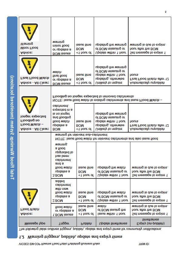
5.6   Reporting to government                                            18
    5.7   Transition to recovery                                             18
    5.8   Management of spontaneous volunteers                               18
6   Capability and complementary plans                                       19
    6.1 Regional and municipal flood emergency planning                      19
       6.1.1 Regional planning                                               19
       6.1.2 Municipal planning                                              20
7   Managing a flood event                                                   21
    7.1 Concept of operations                                                21
    7.2 Readiness activities                                                 21
    7.3 Community information                                                22
    7.4 Local knowledge                                                      22
    7.5 Access to flood intelligence                                         23
    7.6 Access to mapping products                                           23
    7.7 Flood rescue                                                         23
    7.8 Health response                                                      24
    7.9 Restricting access                                                   24
    7.10 Evacuation and relocation                                           24
       7.10.1 Properties located behind levees                               25
       7.10.2 Isolated properties and communities                            25
    7.11 Powers to entry land                                                26
    7.12 Levee management                                                    26
    7.13 Powers to construct, remove or alter levee and/or remove debris     27
    7.14 Property protection                                                 27
    7.15 Resupply                                                            28
    7.16 Management of flooding downstream of dams                           28
    7.17 Energy                                                              28
    7.18 Impact assessment                                                   28
    7.19 Clean-up                                                            28
    7.20 Relief and recovery                                                 28
8   Appendix A – COVID-19 principles and considerations                      29
Appendix B – EM-COP Riverine Flood EM-COP Public Publishing Business Rules   32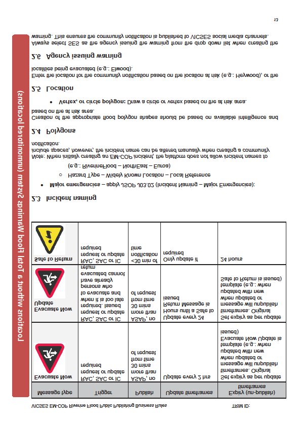
List of Figures and Tables

Figure 1 – Areas susceptible to 1% probability riverine flooding .................................... 5
Figure 2 – Areas impacted by 2010-11floods ................................................................ 7
Figure 3: Understanding flood advice, BoM 2020 ........................................................ 10
Figure 4: Riverine flood Public Information and Warnings infographic (2018) .............. 12
Figure 5: IMT Readiness Arrangements – JSOP 2.03 ................................................. 16
Foreword
Victoria State Emergency Service (VICSES) led an update to the State Emergency
Response Plan (SERP) Flood Sub-plan (the Flood Sub-plan) between August and
September 2020.

The update of the Flood Sub-plan has formed part of VICSES preparedness activities
in response to the Bureau of Meteorology (BoM) releasing Weather Outlook products
for Victoria, indicating significant flooding for large parts of the state during spring 2020.

The update of the Flood Sub-plan has been targeted to address critical components of
the plan to deliver current and accurate information for flood preparedness and
response activities. The update was undertaken solely by VICSES and precedes the
comprehensive and collaborative update scheduled to occur in 2021.

The objective of the update includes provision of current and accurate information
relating to:

   •   VICSES changes in organisation, agency roles and responsibilities, and
       utilisation of sector tools such as the use of EM-COP and VicEmergency.
   •   Evolution of the sector in relation to multi-agency and cross border
       arrangements, including access and deployment of the Australian Defence
       Force (ADF).
   •   Operational response in a complex and multi-hazard environment that has
       impacted Victoria since late 2019, including bushfires, storms and COVID-19.
       The COVID-19 pandemic is recognised and included as part of the update of
       the Flood Sub-plan, however, to ensure the continued application of the plan to
       be relevant and applicable at all times key considerations and related activities
       to COVID-19 and flood preparedness and response have been included in
       Attachment A.
   •   Any information duplicated from the SERP.
It is recognised that the Emergency Management Legislation Amendment Act 2018
(EMLA Act 2018) will take full effect on the 1 December 2020. As part of the phased
implementation of this legislative reform, the SERP and the Emergency Management
Manual Victoria (EMMV) will be superseded by the State Emergency Management
Plan (SEMP) on 1 October 2020. These changes were deemed to be out of scope of
the urgent update required. Additional components out of scope of the update include:

   •   Any non-urgent updates that do not negatively impact the audience’s ability to
       understand and apply the contents of the Flood Sub-plan.
   •   Any out of date information that is not deemed to cause confusion or risk
       interpretation and accurate application of the Flood Sub-plan.
The Flood Sub-plan will be exercised through any operational response activity that
occurs within a year of publishing, and will be reviewed and updated in 2021 to then
align to a three year planning cycle implemented by VICSES.
1        Introduction

1.1     Purpose
This State Emergency Response Plan (SERP) Flood Sub-plan outlines the Victorian
arrangements for managing floods in Victoria.

1.2     Objective
The objective of the SERP Flood Sub-plan is to provide sources of information and to
outline the arrangements for ensuring an integrated and coordinated approach to the
state’s management of flood events, in order to reduce the impact and consequences
of these events on the community, infrastructure and services.

1.3     Scope
This plan provides strategic information about the Victorian arrangements for managing
response to flood. It includes:
    •   Description of potential and observed consequences of floods to the social,
        built, economic and natural environments (section 2 and 3).
    •   The policy, practices and programs in place to mitigate flood risks and build
        community resilience before, during and after a flood event (section 4).
    •   Where relevant, the arrangements and practices for managing flood response
        and positions with accountability and the agencies responsible for managing
        specific strategies (section 5 and 6).
    •   The multi-agency management arrangements at the national, state, regional
        and local levels (section 7).
This plan provides strategic information about the Victorian arrangements for managing
the response to a flood event. It does not include detail about the operational activities
of individual agencies.

1.4     Authorising environment
The Emergency Management Act (1986 and 2013) is the empowering legislation for
the management of emergencies in Victoria. The Emergency Management Manual
Victoria (EMMV) contains policy and planning documents for emergency management
in Victoria, and provides details about the roles different organisations play in the
emergency management arrangements.

The SERP (part 3, EMMV) identifies Victoria’s organisational arrangements for
managing the response to emergencies. This sub-plan is a subordinate plan of the
                               STATE EMERGENCY RESPONSE PLAN (SERP) FLOOD SUB-PLAN 1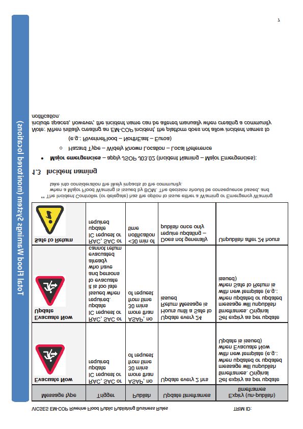
State Emergency Response Plan and has been approved by the State Crisis and
Resilience Council (SCRC).

Other relevant legislation includes:

   •   Emergency Management Act 1986 and 2013.
   •   Emergency Management Legislation Amendment Act 2018.
   •   Victoria State Emergency Service Act 2005.
   •   Essential Services Act 1958.
   •   Planning and Environment Act 1989.
   •   Local Government Act 1989.
   •   Meteorology Act 1955 (Commonwealth).
   •   Water Act 1989.
   •   Melbourne Water Corporation Act 1992.

1.5    Activation of the plan
The arrangements in this plan apply on a continuing basis and do not require
activation.

1.6    Audience
The audience for this plan comprises the Victorian Government and agencies within
the emergency management sector, including business and community groups with a
significant role in the response for floods.

1.7    Linkages
This plan is a sub-plan of the SERP. It reflects legislation, the arrangements in the
SERP, the strategic direction for emergency management in Victoria and the accepted
state practice for managing emergencies. The arrangements in the SERP have not
been repeated unless necessary to ensure context and readability. The SERP can be
accessed at www.emv.vic.gov.au/policies/emmv

Flood plans are also developed at regional and municipal levels. These documents can
be accessed at www.ses.vic.gov.au

It is likely that flood events will occur in conjunction with severe weather. For
arrangements for the management of severe weather refer to the SERP Storm Sub-
plan (Storm Sub-plan) at www.ses.vic.gov.au

Arrangements for the management of secondary consequences are contained in the
following:

   •   For health response: State Health Emergency Response Plan Health Sub-plan.
   •   For rescue response: Victorian Urban Search and Rescue Response
       Arrangements.
   •   For coastal flooding response: State Emergency Response Plan Tsunami Sub-
       plan.

                             STATE EMERGENCY RESPONSE PLAN (SERP) FLOOD SUB-PLAN    2
1.8    Exercising and evaluation
The plan was first operationalised in 2016 in response to a protract flood event that
impacted large parts of the state, and then exercised in 2018. This revised plan will be
exercised through any operational response activity that occurs within a year of
publishing, and will be reviewed and updated in 2021 to then align to a three year
planning cycle implemented by Victoria State Emergency Service (VICSES).

Exercises will be conducted in accordance with the Australian Institute for Disaster
Resilience (AIDR) Managing Exercises Handbook, available at:
knowledge.aidr.org.au/resources/handbook-3-managing-exercises

1.9    Review
This plan was current at the time of publication and remains in effect until modified,
superseded or withdrawn. This plan will be reviewed and updated every three years.
Consideration will be given to an earlier revision if the plan has been applied in a major
emergency or exercise, or following a substantial change to the relevant legislation or
arrangements.

                            STATE EMERGENCY RESPONSE PLAN (SERP) FLOOD SUB-PLAN          3
2        The emergency context

2.1     The flood hazard
Flooding may be defined, as an overflowing or influx of water from its normal confines onto
land not usually submerged. In the Victorian context there are four potential mechanisms
which may cause flooding:

    •   Heavy rainfalls, which cause runoff to enter watercourses, overtopping the banks of
        rivers and creeks, overflowing lakes, detention basins and stormwater drains, causing
        local overland flooding, or resulting in releases or spills from dams.
    •   Many factors contribute to the extent and nature of flooding caused by heavy rainfall
        such as the amount and duration of rainfall, the spatial distribution of rainfall, prior
        weather conditions and characteristics of a catchment including its size, shape, soil
        types, vegetation and land use.
    •   The characteristics of a river also influence the extent of flooding. These characteristics
        include the size and nature of the river, the presence of vegetation in and around the
        river, flood control structures and embankments that may restrict floodwater and
        downstream river levels.
    •   Storm surges, which involve the temporary raisings of sea levels above the
        astronomical tide. These are caused by deep low-pressure systems located off the
        coast and result in sea water invading low-lying areas along the coast.
    •   Tsunami resulting from undersea earthquakes, landslides, meteorite impacts or
        volcanic activity. The arrangements for the emergency management of tsunami are
        contained in the SERP (Tsunami Sub-plan).
    •   Dam failure, which is involves the failure of a dam structure. There are a number of
        significant dams throughout Victoria that both store and provide water to communities
        across the state which have the potential to cause flooding in the event of failure.
        However, there are dam safety risk management processes in place and the possibility
        of dam failure is considered low but consequences could be catastrophic in some
        circumstances.
Flooding in Victoria is influenced by our variable climate, typified by periods of wet and dry
conditions. For full description of climate influences and areas affected see
www.bom.gov.au/climate/about/

 A major factor in this variability is the El Niño – Southern Oscillation phenomena. La Niña,
 the positive phase, is associated with colder than average sea surface temperatures in the
 central and eastern tropical Pacific region. La Niña is normally associated with higher than
 average winter, spring and early summer rainfall over much of Australia, and this can result
 in more flooding.

                                       STATE EMERGENCY RESPONSE PLAN (SERP) FLOOD SUB-PLAN 4
Localised intense heavy rainfall over a short period of time can cause flash flooding to
occur within minutes to hours. As there is little warning time, flash flooding is difficult to
predict and manage. Flash flooding has occurred with significant consequences in regional
urban areas such as the Geelong, Ballarat, Bendigo and Traralgon, as well as across
Melbourne, including the Yarra River precinct. In larger catchments, floods can occur over
several days to weeks, and are easier to forecast and manage.
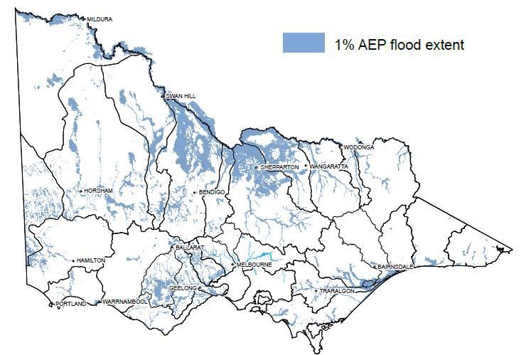
A map of areas susceptible to 1% probability riverine flooding in Victoria is provided below:
Figure 1 – Areas susceptible to 1% probability riverine flooding
STATE EMERGENCY RESPONSE PLAN (SERP) FLOOD SUB-PLAN 53 Consequences
3.1 Possible flood consequences
Victoria has many flood prone communities. The effects of flooding on the community
can include:
• Inundation of properties.
• Damage to essential infrastructure, public and private assets and property.
• Inundation of farmland, damage to crops and loss of livestock and fodder.
• Short or long term displacement of people.
• Isolation of properties or communities.
• Disruption to essential services.
• Death and injuries.
About 11.5% of Victoria’s land mass is prone to a 1% probability flood. Significant
community disruption can occur as a result of damage to essential infrastructure, which
may lead to cascading secondary consequences.
For example a loss of power may result in a loss of telecommunications, traffic signals
and disruption to supply chains amongst other impacts. Damage and flooding of road
infrastructure may result in isolation of properties and/or communities.
3.2 Flood history
From September 2010 to March 2011, Victoria experienced some of the worst floods in
the state’s history. The floods followed heavy rain across south eastern Australia,
which began in August 2010. Over a series of flood events, the worst of which occurred
in the months of September 2010, January and February 2011, approximately 70 local
government areas experienced flood and storm damage.
STATE EMERGENCY RESPONSE PLAN (SERP) FLOOD SUB-PLAN 6Along with the substantial impact to residential property and townships, significant loss,
damage and isolation to rural properties and farms was experienced. Damage occurred
to infrastructure including roads, public buildings and essential services. As at October
2011, the estimated gross total cost of these floods was approximately 1.3 billion
dollars. Figure 2 illustrates the areas affected by these floods.
Figure 2 – Areas impacted by 2010-11floods
Flooding occurred also again across North East Victoria in late February and early
March 2012, causing record flooding in some parts of the Goulburn- Broken River
System. Significant property damage occurred with 135 residences flooded in Moira
Shire (93 in Numurkah), and a further 31 residences damaged in Greater Shepparton
City. Significant damage occurred to local roads, irrigation infrastructure, farm
properties and the Numurkah Hospital.
STATE EMERGENCY RESPONSE PLAN (SERP) FLOOD SUB-PLAN 74 Community resilience
4.1 Shared and individual responsibility for action
Flood events can have significant impacts and effect large areas. As with all hazards,
flood can also not be fully mitigated from potential impacts on the community. As such,
it is imperative that there is a shared responsibility for communities to understand and
take action in an emergency, and for agencies to provide information to aid this
decision.
Refer to the SERP for further information about shared responsibility.
4.2 Flood warnings services
Flood warnings and notifications are provided by the Bureau of Meteorology (BoM),
Melbourne Water and VICSES.
BoM has a requirement under the Meteorology Act 1955 (Commonwealth Act) to warn
the community with regard to extreme weather, and provide the following services to
VICSES. The services provided by the BoM are documented in its Service Level
Specification for Flood Forecasting and Warning Services for Victoria and can be found
at: http://www.bom.gov.au/vic/flood/brochures/VIC_SLS_current.pdf
BoM act as the flood prediction agency for Victorian catchments with the exception of
Melbourne Metropolitan catchments where Melbourne Water is the prediction agency.
BoM formulate and issue official forecasts and warnings for:
• River basins (Flood Watches).
• Key locations on rivers and creeks (Flood Warnings).
• Land and coastal forecast districts (Severe Weather and Severe Thunderstorm
Warnings).
Melbourne Water acts as the flood prediction agency for larger Melbourne Metropolitan
catchments (Yarra, Maribyrnong, Westernport, Dandenong Creek, Werribee, Diamond
Creek, Merry Creek, Kororoit Creek and Plenty River).
It operates a flood-warning network on major rivers and creeks in the Port Philip and
Westernport region and provides flood forecasts to BoM who disseminates official
forecasts and warnings for key locations on rivers and creeks (Flood Warnings).
VICSES provides warnings and emergency information to the community through
releasing complementary public information and warnings published on VicEmergency.
STATE EMERGENCY RESPONSE PLAN (SERP) FLOOD SUB-PLAN 84.2.1 Severe Thunderstorm Warnings (BoM issued)
Severe Thunderstorm Warnings are issued by BoM when severe thunderstorms are
likely to develop, or extend into a specified area over the next few hours. The warnings
are issued for specific areas in the state but are available state wide.
In the Melbourne area more detailed warnings are issued. These warnings depict and
describe individual severe thunderstorms and their forecasted paths.
4.2.2 Severe Weather Warnings (BoM issued)
Severe Weather Warnings aim to provide advance notice of very heavy rainfall leading
to flash flooding or storm surge, which is sometimes exacerbated by abnormally high
tides. They are issued by BoM when severe weather is expected to affect land-based
communities within the next 24 hours which is not directly the result of severe
thunderstorms and are not covered by tropical cyclone or fire weather warnings.
4.2.3 Flood Watches (BoM issued)
Flood Watches are issued for specific regions (e.g. East Gippsland or North East
Victoria) and advise that a flood is possible in those regions. They are issued 24 to 36
hours in advance of any likely flooding and updated as required.
If at any time during this period there is an imminent threat of a flood occurring, Flood
Warnings are issued.
4.2.4 Flood Warnings (BoM issued)
Flood Warnings are firm predictions of flooding based on:
• Actual rainfall measurements.
• Stream level measurements in real time.
• Stream flow based models of catchment behaviour.
• Likely future rainfall.
They are issued for specific rivers when flooding is imminent or is already occurring.
Flood Warnings provide predictions of flood severity (minor, moderate and major) and
the estimations of rise, fall or peak at forecast locations (river gauges).
Flood Warnings and predictions are upgraded and downgraded as a flood rises, peaks
and falls. Any series of Flood Warnings are finalised when floods reach levels below
the minor flood classification.
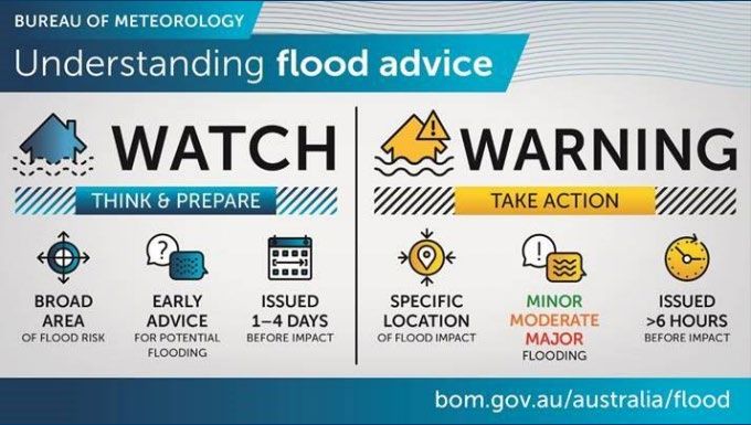
STATE EMERGENCY RESPONSE PLAN (SERP) FLOOD SUB-PLAN 9Figure 3: Understanding flood advice, BoM 2020
4.2.5 Emergency management agency issued flood warnings
VICSES will lead the coordination of public information and warnings that translate the
flood threat identified in BoM Warnings to the likely impact of a flood event to the
community.
VICSES has developed a one-page infographic that graphically depicts how VICSES
warnings align to the BoM Warnings before, during and after the event, along with the
associated communication channels (see Figure 4).
In locations that do not currently receive a flood warning service, otherwise known as
unmonitored locations, VICSES has also developed a process to support personnel
issue warnings. This applies only in instances where there is a verified risk to life or
property that is significant to warrant a flood warning. Further information is available in
the Riverine Flood EM-COP Public Publishing Business Rules.
VICSES will also issue public information and warnings for severe weather,
thunderstorms and flash flooding as the triggers within the EM-COP Public Publishing
Business Rules are met for each hazard.
4.2.6 VicEmergency and warning channels
VICSES use the state endorsed multi-hazard warning platform, EM-COP Public
Publishing, to disseminate public information and warnings to the community via
VicEmergency and its associated channels.
VicEmergency warning recipients include emergency broadcasters (i.e. commercial
and ABC radio) who are required to re-disseminate warning information and sound the
Standard Emergency Warning Signal (SEWS) if required, in accordance with the
Emergency Broadcasting Practice Note and the agreed Memorandum of
Understandings.
A range of approaches are used by VICSES to disseminate public information and
warnings that are selected based on the needs of the community and the nature of the
event. Examples include:
STATE EMERGENCY RESPONSE PLAN (SERP) FLOOD SUB-PLAN 10• Door knocking for evacuation of a small area, if time permits.
• Emergency Alert (EA) for urgent dissemination of warnings to telephones
(including mobile phones) within a specific geographic location (see section
5.2.4).
VICSES ensure public information and warnings align to current best practice, as
outlined in the National Public Information and Warnings Handbook, (see
knowledge.aidr.org.au/resources/public-information-and-warnings-handbook)
and the Victorian Warnings Protocol, available on the Public Information section of the
IMT Toolbox on EM-COP.
The VICSES Riverine Flood EM-COP Public Publishing Business Rules can also be
found on the Public Information section of the IMT Toolbox. A version is also contained
in Appendix B of this plan.
Adjoining states will be consulted over public information messages if impacts have
occurred in a border area.
STATE EMERGENCY RESPONSE PLAN (SERP) FLOOD SUB-PLAN 11Figure 4: Riverine flood Public Information and Warnings infographic (2018)
4.2.7 VicEmergency Hotline
Community members can call the VicEmergency Hotline (1800 226 226) to access
emergency information during and after major incidents in Victoria, including flood
events. It also offers information to help Victorians plan for and recover from
emergencies.
The VicEmergency Hotline is staffed by operators from Monday to Friday 8:00am –
6:00pm, with opening times extended during significant emergency events. The hotline
also features an automatic text to speech function, which ensures Victorians can
access important emergency information outside of operator hours, at any time of the
day or night, by entering their postcode.
The hotline is managed by the Department of Environment, Land, Water and Planning
(DELWP) Customer Contact Centre. The VICSES State Agency Commander may, in
consultation with the State Response Controller, request enhanced readiness and
staffing in anticipation of, or in response to, an emergency event. This may include
extending the operating hours of the centre beyond standard arrangements, including
weekends.
STATE EMERGENCY RESPONSE PLAN (SERP) FLOOD SUB-PLAN 124.2.8 Community meetings
Community meetings are a useful and effective method of disseminating up-to-date
information and engaging with communities. They can be used to provide face-to-face
information before, during or after an incident, to assist community members to make
decisions and educate about the roles of relevant agencies. A ‘virtual meeting’ can also
be held through online platforms where a face-to-face meeting is not possible or to
reach a wider audience (i.e. Facebook Live 1).
The decision to run a community meeting is made within the Incident Management
Team (IMT) through the Incident Controller and Public Information Officer, prior to
consultation with the Emergency Management Team (EMT).
4.2.9 Community safety messages
VICSES use key safety messages designed to promote protective action by the
community. The key safety messages provide action based advice for what to do
immediately before, during and after a flood event. The latest version of the VICSES
Hazard Key Messages can be found on the Public Information section of the IMT
Toolbox.
4.3 Flood mitigation policy framework
Floodplain risk management is a subset of the community emergency risk
management process focused on identifying and analysing flood risks and evaluating
and recommending appropriate flood risk mitigation options.
Prevention activities cover both structural and non-structural measures. Structural
measures have traditionally included flood mitigation works, such as levees, retarding
basins, channel modifications and the flood proofing of dwellings. Non-structural
measures include flood warning services, developing local and municipal flood plans,
land use zoning and building restrictions.
The DELWP is responsible for policy and oversight of floodplain risk management
arrangements. Implementation is carried out at the regional level though regional
floodplain management strategies developed in consultation with local stakeholders
and communities.
The floodplain management function is carried out by Catchment Management
Authorities (CMAs) in regional Victoria and Melbourne Water in the Port Phillip and
Westernport catchments. Local government has a significant role to play in the
administration of land use planning arrangements and accountability for flood mitigation
at the local level.
4.3.1 Victorian Floodplain Management Strategy
DELWP maintains the Victorian Floodplain Management Strategy (VFMS), released in
April 2016. This strategy sets the policy and accountability framework for flood related
mitigation activities in Victoria.
1
Online communication platforms such as Facebook Live are dependent on functioning
telecommunications, powered devices or availability of electricity, and internet connectivity. These
elements should be considered when determining the appropriateness of the channel.
STATE EMERGENCY RESPONSE PLAN (SERP) FLOOD SUB-PLAN 13The strategy is available at: https://www.water.vic.gov.au/managing-
floodplains/new-victorian-floodplain-management-strategy
4.3.2 Regional Floodplain Management Strategy
Regional floodplain management strategies (RFMS) were released in 2017and set out
the implementation of flood mitigation activities for a region. There are nine RFMS
aligning with CMA areas, and consist of Corangamite, Glenelg Hopkins, Wimmera,
Mallee, North Central, Goulburn Broken, North East, East Gippsland, West Gippsland,
and Port Phillip and Westernport.
These RFMS are available from the relevant CMAs, and from Melbourne Water for Port
Phillip and Westernport area. RFMS were developed by CMAs after a significant
consultation phase with community and key stakeholders including VICSES, and were
released in 2017.
4.4 Levee management
About 98% of Victoria’s 4,000 kms of levees protect rural land and are not formally
managed. The VFMS states that flood mitigation infrastructure outside Melbourne
Water’s region that is not currently subject to formal management arrangements will
remain that way unless the relevant Municipal Council (through a RFMS or local
assessment) determines that the infrastructure should be brought into formal
management arrangements through a Water Management Scheme or other
appropriate arrangements. Historically these levees have provided some protection
against minor and moderate floods.
There are a number of smaller levees which protect urban communities. Many have
been constructed by municipal councils to a high standard as Water Management
Schemes, and the municipal councils are expected to maintain them. There are
however, many urban levees for which management arrangements are uncertain. In
the long term, if they are expected to protect urban communities, the management
arrangements will need to be formalised.
Irrespective of whether a levee is maintained or not, all levees can fail unpredictably.
Therefore close monitoring is required during floods to ensure that people can be
safely evacuated. Information on levees has been collated and is available through
CMAs and DELWP. This information is being incorporated in FloodZoom, Victoria’s
flood intelligence platform (see section 4.5 for further information).
4.5 Flood intelligence
Flood intelligence supports decision making and planning for flooding by providing
reliable and accurate information relating to:
• The expected level, depth and velocity of floodwater and its consequences.
• Determination of actions to be undertaken in response to the identified
consequences.
VICSES works closely with CMAs, DELWP, other agencies and trusted local sources,
as appropriate, to ensure available sources of flood information are utilised.
DELWP maintains the FloodZoom flood intelligence platform. FloodZoom is a web
based system and is the central repository of all near real-time and historic flood data
for the State. FloodZoom assists VICSES and other emergency services agencies
STATE EMERGENCY RESPONSE PLAN (SERP) FLOOD SUB-PLAN 14identify the possible local consequences of flooding, and supports CMAs in land use
planning and flood risk assessments.
4.6 Regional and municipal flood planning
Flood emergency planning occurs at the state, regional and municipal level under the
auspices of key forums and committees, formed under the Victorian emergency
management arrangements. Plans recognise the responsibilities that emergency
management agencies, floodplain managers and water authorities have to their
customers and to the broader community. Preparedness activities should include the
regular conduct of exercises to test emergency plans.
Best practice guidance on flood emergency planning can be found in the Flood
Emergency Planning for Disaster Resilience Handbook available as part of the
Australian Institute for Disaster Resilience Handbook Series at:
https://knowledge.aidr.org.au/resources/handbook-flood-planning/
Flood plans are to complement existing emergency management plans at regional and
municipal levels (i.e. Regional Emergency Response Plan (REMP) and Municipal
Emergency Management Plans (MEMPs)). Flood plans should not duplicate existing
arrangements but add value to these in the context of flooding.
All Flood plans should be reviewed at least every three years or under the following
circumstances:
• New flood risk information derived from the Floodplain Risk Management
Process becomes available.
• Implementation of new structural flood mitigation works.
• Implementation of new or upgrade of the existing flood warning services.
• After major floods and exercises.
STATE EMERGENCY RESPONSE PLAN (SERP) FLOOD SUB-PLAN 155 Collaboration, notification
and coordination
5.1 Collaboration, notification and escalation
BoM publishes all Flood Watches, Flood Warnings, Severe Weather and Severe
Thunderstorm Warnings on the BoM website and provides them to pre identified
agencies, organisations, and media outlets.
BoM will email warning messages to VICSES at a state and regional Level. Upon the
receipt of a warning, VICSES as the control agency for response to floods in Victoria
has the responsibility to disseminate notifications and advice to emergency services,
affected communities and key support organisations at state, regional and local levels.
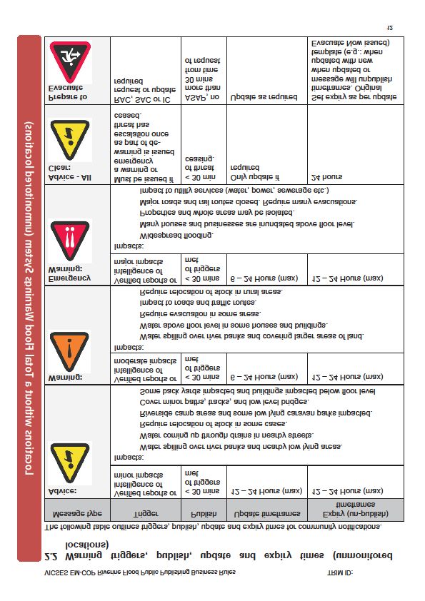
VICSES Flood Readiness and Activation Triggers Considerations employ the following
6 level readiness framework for notification and escalation arrangements in responding
to floods (see Figure 5). The flood readiness levels can be accessed within JSOP 2.03
Incident Management Team (IMT) Readiness Arrangements or the VICSES Flood
Readiness and Activation Trigger Considerations (v4.0).
Figure 5: IMT Readiness Arrangements – JSOP 2.03
If the warning specifically describes a serious and imminent threat based on the advice
from the BoM, the VICSES State Duty Officer (SDO) will notify all emergency service
organisations, including the Emergency Services Telecommunications Authority
(ESTA), via the State Emergency Management Team (SEMT) and relevant agency
SDOs. Regional Duty Officers (RDOs) will notify all regional emergency service
organisations via their EMT and relevant agency RDO.
VICSES Chief Officer Operations is responsible for notifying the Emergency
Management Commissioner (EMC) in accordance with JSOP 3.16 Significant Event
Notification. The EMC can assist through the State Control Centre (SCC) to notify the
State Coordination Team (SCT) and the SEMT. Following the issuing of any warning
product, VICSES will maintain regular contact with BoM and/or Melbourne Water until
the flood risk has passed. Where local information indicates the need for river height
predictions to be adjusted VICSES will advise BoM/Melbourne Water without delay, so
adjustments may be issued if appropriate.
STATE EMERGENCY RESPONSE PLAN (SERP) FLOOD SUB-PLAN 16VICSES has developed a detailed notification process for flood events which is
documented in VICSES Standard Operating Procedures (SOPs).
VICSES understands the need to be proactive in early warnings to the community
regarding the potential for severe weather and its associated impacts. VICSES and
BoM will work in close partnership to ensure the timely notification of flood events in
Victoria.
5.2 Strategic coordination of a flood event
5.2.1 Emergency Management Commissioner
Refer to the SERP for arrangements.
5.2.2 The role of VICSES
VICSES is the control agency for flood. Responsibilities for control agencies are
outlined in the SERP.
5.2.3 Supporting agency roles and responsibilities
A flood event requires a coordinated response from multiple supporting agencies.
Refer to the SERP for arrangements.
5.2.4 Cross jurisdictional arrangements
The cross jurisdictional arrangements to support operational response to flood events
are underpinned by national and inter-state agreements, including:
• Arrangement for Interstate Assistance (AIA) which provides the national
governing arrangements for deployments and support.
• Inter-state Memorandums of Understanding (MOU) between VICSES and South
Australia (SA) SES and New South Wales (NSW) SES respectively, which
detail arrangements for cross jurisdictional response within 40km of the state
boundaries.
Local arrangements are also detailed in VICSES regional plans.
Some of the key considerations when establishing cross jurisdictional arrangements
that are relevant to flood response include:
• Coordination and negotiation for resource requests when additional support is
required by the Australian Defence Force (ADF).
• Use of the national warning platform, Emergency Alert, to provide urgent
information to community members above and beyond state warning platforms
(i.e. VicEmergency).
• Establishment of offline communication (i.e. radio networks).
5.3 Victorian government management arrangements
Refer to the SERP for arrangements.
5.4 Emergency Management Team
Refer to the SERP for arrangements.
STATE EMERGENCY RESPONSE PLAN (SERP) FLOOD SUB-PLAN 175.5 Consequence management
Refer to the SERP for arrangements.
5.6 Reporting to government
Refer to the SERP for arrangements.
5.7 Transition to recovery
Refer to the SERP for arrangements.
5.8 Management of spontaneous volunteers
Refer to the SERP for arrangements.
STATE EMERGENCY RESPONSE PLAN (SERP) FLOOD SUB-PLAN 186 Capability and
complementary plans
The Victorian Preparedness Goal led by EMV sets out the core capabilities needed
before, during and after emergencies occur (see emv.vic.gov.au/our-work/victorian-
preparedness-goal).
The 21 core capabilities in the Victorian Preparedness Goal are highly interdependent
on each other. Many are relevant to preparedness in reducing the potential
consequences of a flood event (i.e. building community resilience) as well as managing
response to a flood event (i.e. search and rescue) as well as the relief and recovery
considerations after it occurs.
For VICSES, these capabilities are developed through its volunteer workforce
supported by paid staff within the responsibilities of being the control agency. VICSES
requires supporting capabilities from across whole of government including for example
access implementation of relief and recovery requirements.
6.1 Regional and municipal flood emergency planning
6.1.1 Regional planning
Regional flood plans have been developed for all six VICSES regions that are
determined to have a flood risk. This includes East (Gippsland), North East (Hume),
North West (Loddon-Mallee), Mid-West (Grampians), South West (Barwon South
West) and Central Regions.
Flood narratives for each of the six regional flood plans has also been created in 2020
as a complementary component to the plans, providing emergency management
personnel with key insights about the known high-risk flood prone locations within the
region that may be impacted with over floor flooding, or have a significant risk to
flooding.
The plans include the identification of suitable incident control and regional control
locations in consultation with other key emergency management agencies. The
selection and placement of these locations must take into account possible access and
damage limitations that could occur during major floods.
Regional flood plans focus on strategic resource coordination within catchment areas
and across the relevant regional boundary, covering the following:
• Regional risk assessment.
• Resource requirements.
STATE EMERGENCY RESPONSE PLAN (SERP) FLOOD SUB-PLAN 19• Locations of significant flood mitigation works of regional importance and their
management.
• Locations of significant essential infrastructure of regional importance.
• Locations of Division Command, and Incident and Regional Control Centres.
• Location of key strategic resources such as incident management personnel,
flood boats, aircraft and sandbags.
• Local knowledge.
• Consequence management.
• Traffic management plans for major arterial roads.
• Arrangements for regional resource coordination and support.
• Identification of significant evacuation scenarios.
• Operation and role of REMTs.
• Areas where other agencies may provide first response flood capability.
• Communication.
• Cross boundary arrangements (intra and inter-state).
• Warnings and community information.
6.1.2 Municipal planning
Where a flood hazard is identified through the Community Emergency Risk
Assessment (CERA) process as a high risk to a community, VICSES will provide
advice and support to Municipal Emergency Management Planning Committees
(MEMPCs) to ensure the MEMP contains arrangements concerning the preparedness
for, and response to, a flood event based on an all hazards and all agency response.
STATE EMERGENCY RESPONSE PLAN (SERP) FLOOD SUB-PLAN 207 Managing a flood event
7.1 Concept of operations
VICSES Flood Readiness and Activation Triggers Considerations employ the following
6 level readiness framework for control and command arrangements in responding to floods.
For readiness levels 1, 2 and 3(a), control is in the VICSES line of control.
For readiness levels 3(b), 4 and 5, control is in the State Response Controller (SRC) line of
control.
The SERP details the functions and roles of regional controllers, and incident controllers in a
multi-agency response (SRC line of control). JSOP 2.03 sets out the default regional and
incident footprints for a multi-agency response (SRC line of control). The SERP outlines
alternative control arrangements and the processes to enact these alternative control
arrangements (e.g. areas of operations).Support agencies functions are outlined in the
SERP and apply for both line of control arrangements.
There may be multiple consequential emergencies resulting from a flood (e.g. fire, building
collapse, hazmat). Refer to the SERP for arrangements in multiple consequential
emergencies.
7.2 Readiness activities
On receipt of advice from the BoM of flooding possibly exceeding the triggers for Readiness
Level 3 (B), the readiness activities may include:
• Establishing the control structure for managing the event.
• Providing consistent emergency warnings and information to the community.
• Implementation of evacuation and emergency relief plans.
• Confirming agencies at all tiers are activated and appropriate response arrangements
are in place.
• Identifying the likely consequences of the flood event and any interdependencies that
may affect planning.
STATE EMERGENCY RESPONSE PLAN (SERP) FLOOD SUB-PLAN 21• Confirming agencies have adequate resources in place to fulfil their responsibilities
and are planning for sustainment and surge capacity, including identification of need
for inter-state assistance.
• Ensuring that flood mitigation structures have been checked and any issues
identified.
• Identifying mass gatherings and large public events that maybe at-risk, and
arrangements to ensure the safety of individuals attending.
• Confirming agencies with call taking responsibilities have resources in place and
back up arrangements to cope with the expected call load.
• Positioning of Emergency Management Liaison Officers from key support agencies to
the State Control Centre and Regional Control Centres, where appropriate.
• Arranging for regular meetings of the State, Regional and Incident Emergency
Management Teams.
• Providing whole-of-government situation reports to relevant Government Ministers.
The SERP details role and agency responsibilities for the above readiness activities at state,
region, and incident level.
7.3 Community information
For agency managed flood, VICSES will lead the community information and media
management function to ensure the provision of timely and accurate emergency information
to the community. For SRC line of control flood, the Incident Controller, Regional Controller,
and/or SRC will lead the community information and media management function to ensure
the provision of timely and accurate emergency information to the community.
Where there are impacts to community, marine areas, roads, parklands and beaches, this
will be done in collaboration with respective agencies that have a responsibility to provide
information and advice to key stakeholder and the community, including Department of
Health and Human Services (DHHS), Victoria Police (Water Police), VicRoads, Parks
Victoria and Life Saving Victoria respectively.
See section 4.3 of this plan for full details relating to the provision of public information and
warnings.
7.4 Local knowledge
The community and other organisations can provide valuable local knowledge about
incidents and how they may evolve. This information is commonly referred to as local
knowledge.
It is essential that communications pathways are created and maintained to ensure
appropriate local knowledge can be captured before, during and after incidents.
As an incident escalates from local control to a larger incident management structure, it is
essential that local knowledge capability is retained within the overall structure.
VICSES has developed a pilot project to improve communication from Flood Observers to
IMTs using the Snap, Send, Solve app. To support the pilot of this project, networks of local
observers has been created in each of the six VICSES regions to provide pictures from the
field to the intelligence section in IMTs depicting flood behaviour and impacts.
Consideration will be given to incorporating people with relevant local knowledge into
relevant roles within an IMT.
STATE EMERGENCY RESPONSE PLAN (SERP) FLOOD SUB-PLAN 22VICSES has developed a Local Knowledge Policy which outlines key strategies for
incorporating local knowledge into the management of flooding, and can accessed at:
www.ses.vic.gov.au/em-sector/em-planning/local-knowledge
7.5 Access to flood intelligence
For a SRC line of control flood, an Intelligence Section will be established comprising
members of DELWP, CMAs, VICSES and private technical specialists. The Intelligence
Section shall use available sources of flood information, including flood studies, gauge data,
mapping outputs (available through FloodZoom) and local knowledge through established
networks such as municipal council, Flood Wardens and local observers to provide
information on possible predicted flood consequences to inform public information and
response actions.
VICSES in collaboration with DELWP has established the Flood Analyst role that comprises
of a number of engineering consulting firms under VICSES managed formal agreements,
along with CMA personnel to deliver technical specialists to support the Intelligence Section.
VICSES has developed and manages internal doctrine to support the deployment of the
Flood Analyst role, and leads the capability and capacity building of those undertaking the
role.
The BoM provides flood intelligence and information in a number of forms when a significant
flood event occurs. In addition to forecasts, Flood Watch and Flood Warnings, the Bureau of
Meteorology will provide regular briefings, and will activate the Victorian Flood Desk to
support 24/7 operational response. The Flood Desk may be contacted by emergency
management personnel to seek further intelligence over the phone. Further intelligence
products may also be created to inform planning activities, such as the Flood Scenario
Outlook.
For high impact weather events the BoM shall provide a meteorologist at the SCC to provide
weather briefings including ongoing liaison and state teleconferences as required. When
staffed, the SCC meteorologist shall be the primary contact for weather information from the
Bureau of Meteorology.
DELWP and CMAs in partnership with municipal councils shall coordinate the collection,
collation, analysis, interpretation and dissemination of post-flood extent and survey levels,
and ensure that relevant information is available through the initial impact assessment
process.
7.6 Access to mapping products
The central repository for the state’s flood mapping and spatial products are available in
FloodZoom and accessible by a link on Emergency Management – Common Operating
Picture (EM-COP).
Printed flood mapping products are also made available at each Incident Control Centre
(ICC), including flood inundation mapping and flood travel time schematics.
Operational response and planning maps may also be generated using e-Map Water by
personnel in the Intelligence Section.
7.7 Flood rescue
Under Victoria’s emergency management arrangements, rescue is considered separately to
the relocation of people who are stranded or isolated by flood water. Where the waters are
STATE EMERGENCY RESPONSE PLAN (SERP) FLOOD SUB-PLAN 23either fast or swift flowing and/or the people being assisted are facing actual or threatened
danger of physical harm the response escalates from relocation to rescue.
Victoria Police, as the designated control agency for water rescue, coordinates rescues
undertaken during flood events.
To activate water rescue services for a predicted flood event (Readiness Level 3B and
above) the EMC, on advice from the SRC, will identify areas at risk of requiring rescue and
notify the Victoria Police Senior Police Liaison Officer (SPLO) Officer in Charge of the Water
Police Search and Rescue Squad to request pre-deployment of Water Rescue resources to
these area via the Victoria Police Rescue Coordination Centre (Water Police and Search
and Rescue Squads).
In conducting rescues Victoria Police will often require assistance of appropriately trained
and equipped personnel from support agencies (including VICSES, Volunteer Marine
Search and Rescue Organisations, the Country Fire Authority, Fire Rescue Victoria and Life
Saving Victoria) to undertake flood rescue. Victoria Police coordinate with these agencies to
ensure operational readiness for activation.
In significant flood events, Victoria Police will appoint a Flood Rescue Manager, who may be
an officer from Victoria Police or one of the support agencies. The primary responsibilities of
the Flood Rescue Manager are to:
• Coordinate all Flood rescue activities.
• Identify and source required resources.
• Deploy required police and support agency resources.
• Contribute to the development of the rescue plan for the incident.
7.8 Health response
Refer to the SHERP for arrangements.
7.9 Restricting access
To ensure public safety, it may be necessary to restrict access to affected areas. Victoria
Police and relevant land managers will coordinate the restriction of access to these areas as
directed by the Incident Controller.
Traffic management will be conducted in accordance with the Joint Standard Operating
Procedure for Traffic Management (JSOP3.10).
Analysis of traffic management requirements and development of traffic management plans
will be undertaken in consultation with relevant road managers.
7.10 Evacuation and relocation
Evacuation is a risk management strategy, which may be used as a means of mitigating the
effects of an emergency on a community. It involves the movement of people to a safer
location. However, to be effective it must be correctly planned and executed.
In Victoria, evacuation is largely voluntary. The Incident Controller makes a recommendation
to evacuate and it is the choice of individuals as to how they respond to this
recommendation. However, in particular circumstances legislation provides some
STATE EMERGENCY RESPONSE PLAN (SERP) FLOOD SUB-PLAN 24emergency service personnel with authority to remove people from areas or prohibit their
entry e.g. Coroners Act 2008 (sections 37(2), 37(3) & 38(1)).
Evacuation operations should be consistent with Evacuation Guidelines available on EM-
COP (see files-em.em.vic.gov.au/IMT-Toolbox/Inc/EvacuationPlanlines-v2.0.pdf) and
Joint Standard Operating Procedure on Evacuation (JSOP3.12).Guidelines for best practice
for planning evacuations are provided in AIDR Handbook 4, available at:
www.knowledge.aidr.org.au/resources/handbook-4-evacuation-planning/
Some special evacuation considerations exist in specific environments which are detailed
below.
7.10.1 Properties located behind levees
Levees are flood mitigation structures which aim to reduce flood frequency by creating a
barrier between floodwaters and elements at-risk. Levees have been used across Victoria in
an attempt to reduce flood damages and enhance public safety.
Levee owners / operators are responsible for the maintenance and operation of
levees. Monitoring of a levee is the responsibility of levee owners / operators. Best practice
guidelines for levee management are available at www.delwp.vic.gov.au/water/floods-
and-floodplains/floodplain-management
All levees, however, unless designed for Probable Maximum Flood (PMF) events, will
ultimately be over-topped by events larger than their design events, or possibly fail through
lack of maintenance, inadequate construction or unforeseen circumstances for floods of
lesser magnitude than the design specifications
Since the performance of a levee that is formally maintained cannot be assured after its
design height or design specifications are exceeded, the design height or design
specifications should be used as the trigger for evacuation when a levee is in danger of
over-topping. For levees that are not formally maintained, there is no guarantee that a levee
will hold when tested by a flood.
Augmentation of levees through temporary means (e.g. sandbagging) cannot be considered
as alternatives to evacuation. Such works should be considered only as attempts to protect
property and consideration must still be given to evacuating at-risk residents. Such works
should also be undertaken only after technical advice is sought regarding their potential
consequences on flooding and authority to undertake the proposed works.
Levees may be in danger of failure due to breaching and therefore must be carefully
monitored to ensure any signs of piping or seepage are identified. Where such observations
are made or there are concerns about the structural integrity of a levee, evacuation of the
protected community should be considered. Specialist geo-technical advice may be sought
regarding the stabilisation of a deteriorating levee. However, evacuation should occur and
continue until a levees integrity can be assessed as safe.
Incident Controllers should always consider that no levee is flood-proof and that levees are
primarily a mechanism for the protection of property, not life. Where there is potential for
levee over-topping or a levee breach, evacuation must be considered.
7.10.2 Isolated properties and communities
The isolation of people is not without risk. Where it is viewed that people are unsuitable to
remain in a property that may become isolated based upon predicted flood heights, they
should be encouraged to evacuate. Such people may include:
STATE EMERGENCY RESPONSE PLAN (SERP) FLOOD SUB-PLAN 25• Unprepared property owners.
• People dependent upon medical care.
• Families with young children.
• People who are immobile.
• People who suffer from physical disabilities.
• People who suffer from health conditions that are likely to be exacerbated through
either direct exposure or stress caused as a consequence of flooding.
• People who are frail.
7.11 Powers to entry land
The VICSES Act 2005, Part 3, Section 32AB provides the power to enter land or premises
with or without the consent of the occupier of the land or premises if a service member
reasonably believes that entry is urgently required to protect life or property in the course of
responding to, or preparing for, a flood, earthquake, storm, landslide, or when undertaking a
rescue.
The risk to life or property must be deemed urgent for members to enter land or premises
without consent. To this end, and to support consistency and effective management of
incidents, the VICSES Chief Officer Operations (COO) has determined in SOP035 ‘Entering
land or premises during operations’ the steps to be followed by authorised personnel in
making a decision to enter land or property. Members are required to comply with this SOP.
Only Incident Controllers, VICSES Crew Leaders and VICSES Agency Commanders at
incident, regional and state tier are authorised to make a decision to enter property with oral
consent or without the consent of occupiers.
Section 32AB applies to VICSES members, or a person who voluntarily places themselves
at the disposal of the COO and is directed by a service member. Therefore, such directions
should be noted in logbooks where a support agency is operating under the control
structure.
Where a decision has been made to enter land or premises without consent, the authorised
person who made the decision to enter the property must ensure that the SOP035 is
followed in regards to notifying the occupier in writing that the service (or its representative)
has attended to deal with an emergency situation. Victoria Police are to be notified through
VICSES dispatch (or line of control) should there be threat to life.
7.12 Levee management
Levee owners / operators are responsible for the maintenance and operation of levees.
Monitoring of a levee is the responsibility of levee owners / operators.
Levee owners / operators must keep the Incident Controller informed of the levees status
and be prepared to provide expert advice to the Incident Controller about the design and
construction of their levee.
The Incident Controller may assist levee owners to coordinate resources, both technical and
physical, to provide advice and affect temporary repairs or augmentation to levees.
STATE EMERGENCY RESPONSE PLAN (SERP) FLOOD SUB-PLAN 26You can also read